


The City of Lib: Key to Book of Mormon Geography
The City of Lib
Key to Book of Mormon Geography
Transcript of the September 2005 BMAF Conference Presentation
by Garth Norman
My approach to the Book of Mormon, as a professional archaeologist, for over four decades, has been researching the Book Mormon and archaeology assuming the Book of Mormon as a history of ancient America. I consider that a fact simply based on what the Prophet Joseph Smith told us and what he presented.
There are a number of ways or approaches to the study of the Book of Mormon. I candidly don’t recommend archaeological study of the Book of Mormon until you have read it at least ten times, and you want to branch out and expand with various approaches. Joseph Fielding Smith and President Ezra Taft Benson, quoting Joseph Fielding Smith said, "We should not be content in our study of the Book of Mormon until we can bear witness that its history is true." For me, as an archaeologist, I have a conviction that it is true and that it encompasses history because it is a historical document. And there are plenty of references from the Lord in the Doctrine and Covenants that admonish us to study history and cultures. In this regard, I know of no ancient history with a more dynamic and challenging contribution to the world than the Book of Mormon. I’d like to think of it in terms of sacred history lessons the same as we regard the Bible, because we know where the Bible took place. Historically, archaeologists can very freely and openly research, and have done for many years, the archaeology of Palestine and neighboring areas and are able to tie many things to the Bible. We have not quite reached that point yet with regard to the Book of Mormon. I think, not because it’s not desirable, but because we haven’t as a people, as Book of Mormon students in general, studied ancient history sufficiently to be able to approach it seriously. Also, we LDS scholars are not quite united yet about a lot of things to be able to make that possible.
So, I’m going to tackle something here today, and propose to you that we identify a Book of Mormon city. Hugh Nibley made this comment on several occasions, "if we could find a sign on a road leading into the city of Zarahemla that said ‘Welcome to Zarahemla’ we’d have something concrete to go on, and we could be confident then that we were in the right place, and be able to research Book of Mormon lands from that point." Well, that’s modernistic isn’t it? We have discovered no such signs in ancient America right now, however, there may be some. We just haven’t learned how to read them yet. I’m going to propose to you that there are signs; and I’m going to offer one to you today.
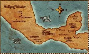
The Book of Mormon for me (holds up a reprint of the 1830 edition) is a history of ancient America, centered in Mesoamerica, middle America, and I take as my first authority in taking that position the prophet Joseph Smith. When the Prophet, in the early 1840’s, was reading about John Lloyd Stephens' explorations in Central America and the Yucatan. He became excited, along with others, about the prospects of the relationships to the Book of Mormon. We saw a big shift in the thinking in the Times and Seasons in 1842, when the Prophet printed extracts, as editor of the Times and Seasons, of Stephens' books, and then saying that this is where the land of Zarahemla was located, i.e., in Central America, in the area of Chiapas and that general area. So, that was the starting place of placing the Lehites in Mesoamerica.
The Popol Vuh is the sacred book of the Quiche Mayas of Guatemala. It contains history and it contains religion and tradition. It is a kind of history that compares to the Book of Mormon. For me (holding up the two books), the Book of Mormon and the Popul Vuh are the two major works that are available to us in reconstructing pre-Columbian history in Mesoamerica (Central America). And, there are many other sources, as well. As an archaeologist, however, I don’t find too many of my non-Mormon colleagues, and actually not a lot of my Mormon colleagues, who like to deal with the Book of Mormon as history. So, we’re out in a minority, on a limb, so to speak; but I submit to you that we can potentially learn more about the real history of Mesoamerica from the Book of Mormon than we can from the Popol Vuh or from professional anthropology or archaeology. The difference is that they don’t regard transoceanic migrations as being viable or significant. They believe there is an evolutionary process of development of civilizations in the Americas without transoceanic contacts. This rules their thinking and helps them determine what they are going to look at seriously.
I would like to start out with a few slides and show some overhead projections about specifics. As you know, there are various theories circulating as to where the ships (Lehite and Jaredite) landed. What we regard as evidence for the Mesoamerican setting has developed over many, many years. And, why Mesoamerica? We’re going to do a quick geographical tour and deal with this area of Mesoamerica (Central America) as the high civilization area. There isn’t much else to go on in terms of the requirements of the Book of Mormon geography that can seriously put one into any other area than Mesoamerica. The question for us, really, is how much evidence is there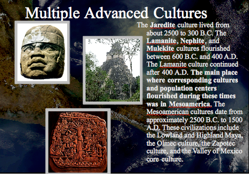 ? And that is an ongoing question, because it’s a research problem, with continuing excavation, analyzing remains, and getting proper cultural relationships of the time period.
The image to the left shows us the advanced cultures in the Book of Mormon and their approximate time periods.
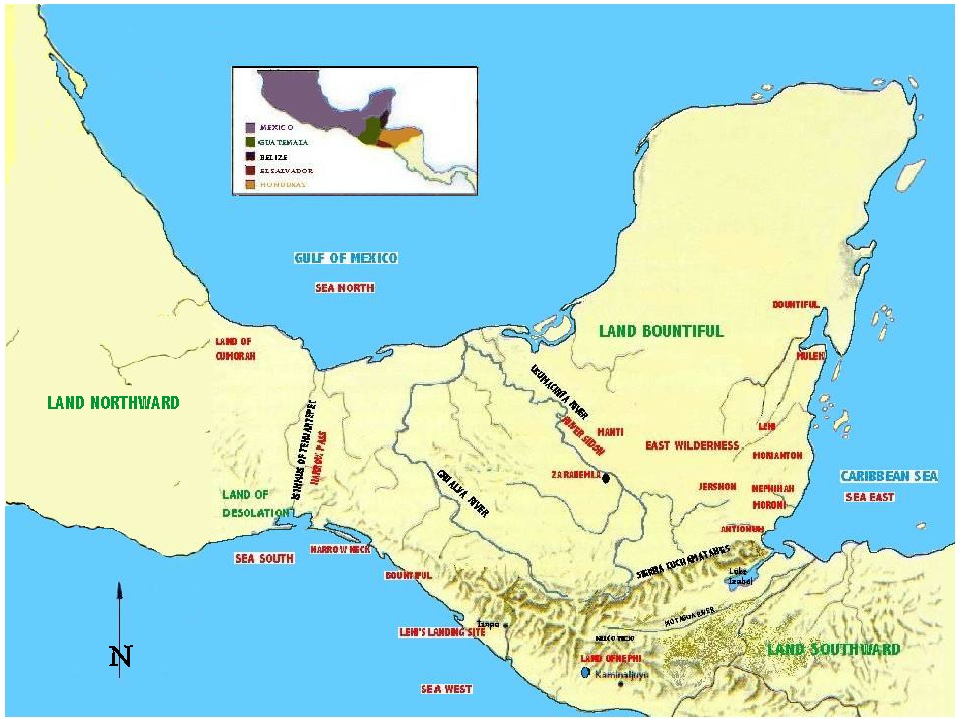
For many years we’ve been looking at this kind of map (right)of the correlation of the Book of Mormon and the chronicles in terms of the land northward and the land southward.
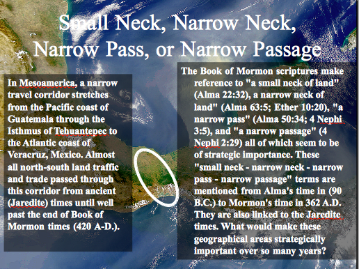
At left is the Isthmus of Tehuantepec as the Narrow Neck of Land. I just want to quickly give you the criteria of the Narrow Neck in terms of the Book of Mormon. Here is where the two lands meet – the land of Desolation, characterized by being desolate of timber, and the land of Bountiful, characterized as a heavily forested region. What we see in the bulk of this area of Oaxaca and on the Pacific coast is dryness, extending over to the tropical area on the Atlantic side.
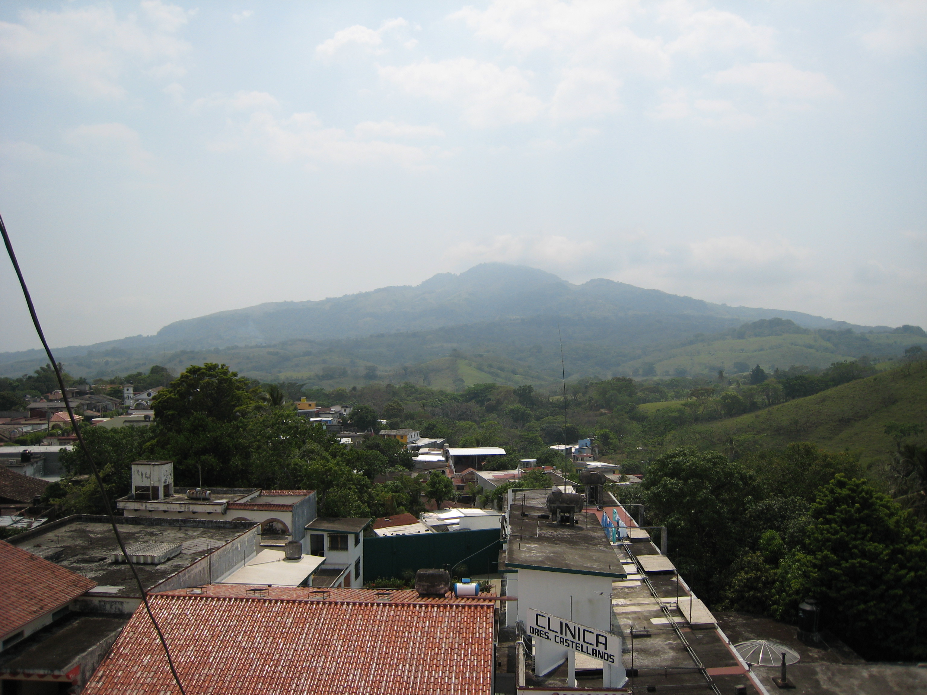
This is the coastal plain of Tehuantepec, which, I suppose, is the best candidate for the Narrow Pass. (left)
This is the Mormorato Lagoon, in the Pacific area, which qualifies as a port for Hagoth’s shipping. (Need photo)
On the Atlantic side, this is the Cerro Vigía in the Tuxtla Mountains (right) as the land of Cumorah. There is a lot to recommend it. On the Gulf of Mexico, we can see across the Gulf waters to the Tuxtla Mountains. They are very prominent landmarks.
Under the city of Coatzacoalcos on the Río Coatzacoalcos are ruins, and above the city are mounds and ruins that to me is the best location for the city of Bountiful. But it needs to be studied. (Need photo)
Now, I’m just going to run through quickly (need photographs) – the waterways, the drainages here on the Gulf coast are very descriptive of the Book of Mormon condition, showing mangrove swamps, lots of wild beasts: caiman alligator, jaguars, tapir. This appears to be a tapir hunter with a horn on his cap; lots of tropical birds, puma, deer, black jaguar, monkeys, and maybe even elephants.
(Need slide) This is a boat (carved canoe), and here we are going to jump back in time. Notice the style of this boat. We can go back 3000 years and see the same style of canoe in a jade carving from the Olmec period. And in Izapa, we see the same style or form. (need Photo of a stela with canoe incised on it.)
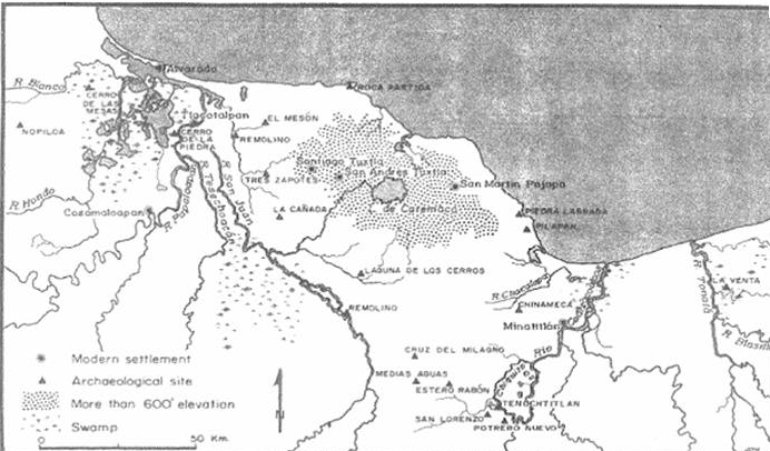
This is a map of mine that is in production. (need jpg) I’m just going to point out for orientation purposes (points to various places on the map shown on the screen from the overhead projector), here is where I place the Narrow Pass, and across the Narrow Neck of land, which is the Isthmus of Tehuantepec, and here on the Río Coatzacoalcos is San Lorenzo, which is a possible city of Lib that I proposed a few decades ago, and then here is La Venta.
(On the next map) The detail here, you can see the waterways and La Venta. What I want to point out here is with the ruins of San Lorenzo. M. Wells Jakeman actually proposed this back in the 1950’s, and after Michael Coe’s excavation, I examined the results and saw some striking correspondence in time as well as culture to qualify for the city of Lib.
What I want to point out here, as a result of our current knowledge of this territory, is that near Coatzacoalcos here on this map, there are ten different locations that date to the Jaredite period, we call this the Olmec period in archaeology. Along the drainage up here are extensive ruins dating to that Olmec period. Keep in mind that in the Book of Mormon, what do we learn from the text about the city of Lib? It was located or built in the days of king Lib.
As a result of the prior drought, poisonous serpents had hedged up the way so that they couldn’t move into the land southward for some time. So in the days of Lib, they killed the poisonous serpents, and from that point, Lib and his people moved into that forested territory and built a city. Lib built a great city.
On the Río Coatzacoalcos, currently it does not qualify really, because there are a lot of other ruins in that area.
The city of Lib was at the frontier going into the forest, where he became a great hunter. So they evidently had a game industry going on with hunting in the forest.
 La Venta, I propose to you, is the best candidate for the city of Lib, based upon that bit of evidence.
The other clue we have for locating Lib is where Moroni was translating he inserted a statement that the city of Lib was built near the place where the sea divides the land So Moroni evidently knew where this city of Lib was. And the geographical features show that is on or near the Narrow Neck of land where the sea divides the land. This leaves us with somewhat of a mystery because of the production of silt over the centuries, we don’t have a distinct place where the sea divides the land.
This past summer as I was doing research on this subject I picked up the book by Phillip Drucker of his excavations at La Venta back in 1952. And this is what I read, "The traveler in this region cannot help but feel impressed by the sudden change from the rolling red hills of Minatitlán, which are a gradually descending foothills of the Tuxtla Mountains, and the high sand dunes around Puerto Mexico, to the flat swampy plain just barely above sea level that extends for miles to the eastward along the coast." So we see this swampy territory and flooding during the rainy season. Then there is this key statement, "This whole swamp was formerly open sea, a great bay that gradually silted in." Now, we can agree with that geologically. Then he continues and says, "Oil field geologists working in the La Venta zone have told me that testing and drilling operations show a layer of almost 100 feet of swamp muck extending downward from the present surface, with here and there bits of marine or brackish water shells." Now listen to this, "Potsherds and fragments of figurines often come from considerable depths in this muck."
So, the petroleum drillers getting their core drills out were bringing up potsherds and figurines, and he concludes that these were not really ancient but were datable to the La Venta culture, and they were just lost from boats – maybe from getting swamped on occasion. "Potsherds and fragments of figurines often come from considerable depths in the muck. We can be certain that these objects do not present ancient horizons or were buried in modern times, but were undoubtedly lost from canoes at a time when there was more open water than at the present day."
Now when I read this it hit me like a bolt of lightning that I had known, of course, that La Venta was on an island in a swamp area, but I didn’t realize that this was an island in an inland sea back in Olmec times. So here is a city that dates to the time of King Lib on the Narrow Neck of Land that was built near a place where the sea, literally, divides the land. With that bit of insight, I decided it was time to take another hard look. If La Venta is the city of Lib, we should be able to find more concrete evidences to identify it with Lib.
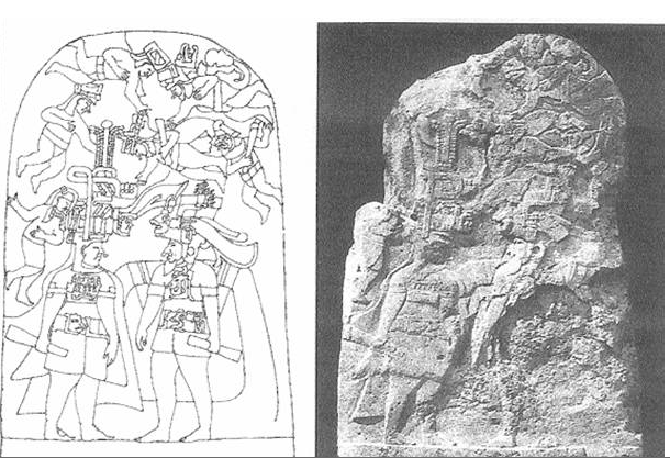
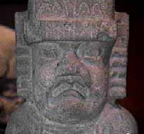
Stela 3 from La Venta is the most famous stela. The stela is huge and those figures are life-sized. When this was excavated, it appeared that, along with other monuments, it may have been intentionally buried. Possibly it had become obsolete, or after a conflict some people buried it for its protection; but you can see the spalling and damage in some areas. This drawing (left) is a reconstruction of the stela.
In 1946, the famous Uncle Sam figure on Stela 3 was described by Mexican archaeologist, Miguel Covarrubias, as a fully-bearded man with an enormous aquiline nose with surprisingly pronounced Semitic features. Two decades later, arch-historian Tatiana Proskouriakoff , of the Carnegie Institute of Washington, referred to the same bearded figure here on Stela 3 as "a visitor; and with low relief carvings in the same area as a racially distinctive group of strangers or foreigners.
These foreigners eventually gained ascendancy over another stocky racial type. And these La Venta carvings are also described as credibly realistic portraits and descriptions of historic scenes from a highly developed religious society."
So we have two unsolved mysteries about La Venta: The absence here and in the neighboring areas of developmental antecedents for this highly developed civilization. And, why the Olmecs did not spread east across the tropical lowlands into the later Mayan territory of Yucatan. (Garth: this is outdated, recent data shows major movement of Olmec into Yucatan) La Venta, here, was the eastern frontier, although there is evidence of some contact and isolated settlements, but the spread and development of this coastal civilization just stopped right there at La Venta. So, archaeologists are puzzled about that and they don’t have an answer. The Book of Mormon gives us the answer, assuming that we’re in the right place. As already stated, they were preserving this forested land southward as a game refuge. The population was spreading all over the land northward, but they were preserving this tropical forest in the land southward.
Archaeologists are still trying to learn how to read the symbols and signs; and I’ve spent much of my career at the related site of Izapa working for BYU and the New World Archaeological Foundation on those monuments, and they are closely related to these monuments here at Le Vena (Stela 3).
We have two time periods here at La Venta: the early Jaredite period (Olmec); and then it evolves into another kind of culture, which I’ll show you momentarily, tying into the land southward during the Izapa period that would be the Lehi era of the Book of Mormon.
What do we see on this figure (Points to a new overhead slide.need)? That’s a fish in his headdress. It also has other elements, of course. But the iconographer who has studied this in detail has confirmed that that is a fish. So, what is a fish doing on top of this king’s head? This is a kind of writing system, which we call ‘rebus’ writing. We don’t see glyphs or script, but you may be acquainted with Izapa Stela 5 and the rebus-type headdress glyphs over the Lehi figure and his companion, Sariah. Here is the same kind of thing – rebus writing. So, if this is a fish on top of this king’s head, let’s look at that and see what we can find in terms of possible name glyphs.
A linguistic analysis of the name ‘Lib,’ has led me to look at this fish on Stela 3. Names in pictographic writing on stelae are commonly represented by rebus, which is a symbolic picture of the name. The meaning of ‘lib’ is – white, as seen from related Semitic names, including Libnee, Libnah, Laban, Libanah, Libanas, which is ‘White Mountains of Lebanon,’ such as snow-capped mountains there suggested by some scholars as the origin of that.
Libu, Libya, and Labni in Syria have the same roots. This meaning from Jaredite times is indicated from Jacob’s father-in-law, Laban, which would mean ‘white,’ who was living in the Jaredite homeland of Haran. So scholars believe that Maya is a language of the ancient Olmecs (whom we believe were the Jaredites); so the Yucatec Maya place name Labna may also relate to lib, but we don’t have a means for that in the Maya. Now, Mesoamerican words and hieroglyphs for ‘white’ in different Maya dialects are translated as a possible frog or a fish. I believe that one of the images interpreted by Erik Thompson as having sharp teeth is really more characteristic of a fish.
So, that’s what I would propose here today in the identification of some Mayan words that have a relationship with some words in the Old Testament that mean fishing, including Sidon, which is derived from Zidon in the Phoenician, and Sidon, which is the Hebrew version.
Another fish glyph is tcaix, which is close to tzoc, which means ‘to count,’ which may have actually originated from fisherman counting their catch. A count completed in Yucatec Maya is tzoc or zac. These near identical words are a natural phonetic complement, and are related to ‘shark’ and ‘shark skin color,’ which ranges from gray to white; and, of course, the meat of fish commonly is white; so I would propose that that is the relationship to white and the fish in the Mesoamerica glyphs.
To test this identity, we can look for candidates for ‘white’ in the Book of Mormon. First, from the white Tree of Life on Stela 5, and from Lib’s name as proposed here in Stela 3. So, I’ll come back to, but merely mention that on Stela 5, on the upper left hand corner, we have two fish hanging down from the sky band. And they are penetrating the head of the clouds on the sky-serpent and also coming in contact with enlarged leaves and fruit on the end of the branch of the Tree of Life. I propose that the zac glyph is identifying the tree as being white. That is a correlation for the Tree of Life in the Book of Mormon.
So, king Lib on Stela 3, as proposed here, dates to around 900 B.C. The fish on this Semite bearded king’s head has been a puzzle. We have a reasonable interpretation from the Book of Mormon connection as identified with Lib. Now, this doesn’t stand in isolation, however.
Here is a La Venta stela that shows a bearded king grasping the body of what appears to be a sea-serpent; or maybe a composite of a fish and a serpent. Notice how as he grasps it, the serpent looms menacingly over him. Is this another rendering for Lib as perhaps, not only identifying him by name, but in this depiction, identifying him as the king destroying the serpents?
(Need photo) This is a drawing of a throne from San Lorenzo identical in style as one from La Venta. Some scholars think that some of the La Venta carvings may actually have been transported from San Lorenzo, but that, of course, is uncertain. But here, the king on the side has another name represented by a bird claw on his headdress. He is also wearing the cross-section of a conch. This may be the earliest representation of this in Mesoamerican art., which is an emblem of the god, Quetzalcoatl in later Mexico. But, here is a ruler with the bird’s talon representing his name. Also in the days of Lib, in that period of time, we have the king, Com. In Bruce Warren’s study of Maya, he recognizes this as a name for ‘feathers’ or ‘bird.’ So, maybe we have here a candidate for this king.
We’ll shift now, and go back to the slides. We’re going to buzz through some slides, and I want you to get a feeling for this territory of La Venta and the land Bountiful. Here (need slide) we’re on top of the pyramid at La Venta. And the view over the swamp land toward the Gulf coast, a distance of approximately 12 miles. So you can imagine along these drainages when this was a large island that there was a pretty good-sized inland sea back then.
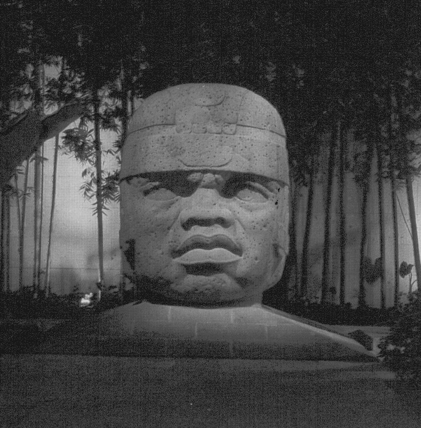 This next slide(right) is one of the Olmec heads that are believed to be actual portraits of Olmec kings in some cases. The carvings and stones here at La Venta are very impressive. Here’s one that is transitional into the late period. The actual end of La Venta, we know now, was around 200 A.D.
Here the king has a serpent headdress, (need) and he’s reclining on a serpent. His identity is related to the box-glyph above his head. I’m proposing in my research that this is a Mulekite-Nephite period carving, closely related to Izapa, by the way, and translating Lib’s name here at La Venta into Hebrew. The transliteration process in a nutshell, when you go from one language to another, if it was in Semitic then we have some vowel and consonant changes, which raises the possibility that the box over the king’s head represents the name Lib in Hebrew.
Here’s another photo (need) of the transitional period stela showing a king, a jaguar and water flowing from his niche filling these vessels. Now, in my view there is some to interpret this as a monument to Mulek. These panel styles are very closely related to Izapa. The carvings date to after 400 A.D. through about the time of Christ.
I want you to get a feeling for this culture that we’re dealing with. It’s not a primitive culture. It was a very highly developed civilization.
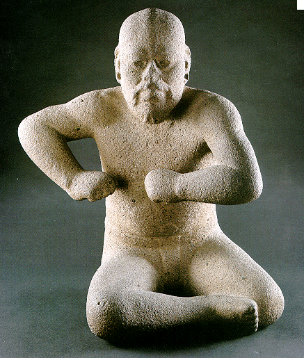
Here is a very artistic creation of a wrestler. You’ll notice that he has both a beard and a mustache. His face looks almost oriental to me, and it may be.
There are ceramic figures of highly skilled production. Here’s (need slide) a stone carving of a life-sized mask, very beautifully done, and highly polished. The use of jade was very prominent in their culture. These were the first jade-carvers. And one thing about jade is that it is a very hard stone, and they able to carve it meticulously and it is very highly polished, and there is no grinding marks on it at all.
Here (need photo) is a concave mirror with holes from which it was held by a string, so that it was placed over the neck as is illustrated on this figurine. (Shows a photo of a seated figurine.) We still don’t know how they did this – it’s been almost duplicated – but what we can admire is the skill and technology of this civilization that was able to produce this kind of reflective mirror.
 You will notice there is an emphasis on jaguar symbolism. (right) This stela is a Jaguar-child.
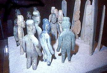
This (left) is a tomb and stone carvings (miniature figurines) that came from inside the tomb. Perhaps it represents a meeting of some kind.
This is a large mosaic piece.(right) The interesting thing about this is that it was buried in the La Venta ceremonial plaza, about 15 feet down in the ground. It was never used as a ceremonial platform, it was a dedicatory offering to the jaguar god. A tremendous amount of labor and huge volumes of precious stones were used in its construction.
Here is another carving of a stone with jaguar features. This slide is from Izapa, where a large boulder is carved as a jaguar’s head with a human figure inside the mouth. (need)
(Need slide) What we have here is simply that jaguar symbolism took different forms. Some were undoubtedly occult imagery. They could have been used similar to the Gadianton robbers in forcing their religious beliefs. It ws also adaptable, in a religious sense, to life death and underworld connections.
We’ll wind this up with some information on measurements. We have to have a Middle-eastern tie, and I presented this last year, but I just wanted to explain it again that these carvings at La Venta have the 49.5 centimeter cubit (Need photo). They used extensively this figure as a quarter scale of that. And we’ll end on that.
In conclusion, we have geography, we have culture, we have high civilization and Middle-eastern connections in the culture and with the evidences of Book of Mormon names now.
So, we have a long ways to go, but we’re on the track – and, keep tuned in. Thank you.