


Response to Jonathan Neville’s Two Books: Moroni’s America: The North American Setting for the Book of Mormon and Letter VII
Contents of all BMAF publications are the sole responsibility of the individual authors and do not necessarily represent the view of BMAF or The Church of Jesus Christ of Latter-day Saints
Response to Jonathan Neville’s Two Books: Moroni’s America: The North American Setting for the Book of Mormon and Letter VII
Copyright © 2016 by Joe V. Andersen
Jonathan Neville in his new book, Moroni’s America: The North American Setting for the Book of Mormon,[1] erroneously claims that Mesoamericanists look under the wrong light of the 1842 articles in the Times and Seasons for their light and knowledge of the geography of the Book of Mormon. He proposes, “When we read the Book of Mormon under the light Joseph [Smith] and Oliver [Cowdery] provided, we see it in a completely new way” (p. xi). Neville further states, among other things, that we need modern revelation to match real-world locations with Book of Mormon locations (p. 11). To support his thinking, he relies heavily upon his proposal that Oliver Cowdery received revelation to the effect that the location of the Hill Cumorah in New York is the location of the final battles of the Book of Mormon people. He cites Cowdery’s Letter No. VII: Oliver Cowdery’s Message to the World about the Hill Cumorah[2] in an attempt to show that Cowdery received revelation about the Hill Cumorah’s location in Palmyra, New York, which he claims is the same hill Ramah/Cumorah described in the Book of Mormon.
Neville makes the following foundational statements at the beginning of Moroni’s America:[3]
- “What we need is a reliable starting point—a reliable pin in the map. That’s why we need modern revelation” (p. 11).
- “Oliver Cowdery explicitly and unequivocally located the hill Cumorah in New York. . . I stick a . . . pin in the map in western New York” (p. 12; Letter VII, pp. 57–65).
- “D&C 125:3 says, in part, ‘Let them build up a city unto my name upon the land opposite the city of Nauvoo, and let the name of Zarahemla be named upon it.’ This verse is not conclusive about geography, but it doesn’t need to be. The Lord named the site Zarahemla. I want to see if it fits so I stick a pin in eastern Iowa, along the Mississippi River across from Nauvoo [Montrose, Iowa]” (p. 12).
- “There it is. Book of Mormon geography in a nutshell” (p. 12).
And that is his “modern revelation?” His book contains myriads of “new ways” of justifying the North American setting for the Book of Mormon, claiming that when readers look at this new way (new revelation, see p. 13 referencing the ninth article of faith about future revelation) through the lenses of Joseph and Oliver, the following examples of some of the geographical facts are “revealed”:
- That Joseph Smith was buried “in an ancient Nephite cemetery in Nauvoo across the river from Nauvoo” (see p. xi).
- That Montrose, Iowa, located on the west side of the Mississippi across from Nauvoo, is the Book of Mormon city of Zarahemla (p. 12).
- That “sea west in Alma 22:27 had to be the lower Mississippi River,” meaning south of the confluence of the Ohio and Mississippi rivers (pp. 34 and 36).
- That the west sea was also Lake Michigan (pp. 37, 189).
- That the west sea was also Lake Erie (pp. 312–315).
- “That head of the river is also where the river Sidon flows into the sea west” (p. 46).
- That “perhaps the entire section from the Missouri to the Ohio River, is the head of Sidon” (p. 279). But more likely “head of Sidon . . . refers to a confluence of rivers [in this case the Illinois and Missouri]” (p. 46).
- That Lake Ontario is the east sea (p. 265).
- That the east sea is also the Atlantic Ocean (p. 36).
- That the narrow strip of wilderness is the full length of the Ohio and Missouri rivers (p. 19), including the Mississippi between its confluence with the Ohio and Missouri rivers (p. 53).
- That the east sea is also the Mississippi River/Sidon (see pp. 164–65) and that “Moroni had fortified the land of Jershon, and presumably the sea, or mighty river, it bordered” (p. 169. Thus, according to Neville, Jershon is located on the east side of Sidon/Mississippi (p. 169) and not near the east sea as required by the Book of Mormon.
- That the terms “down” or “up” mean “simply moving with or against a river current” (p. 39).
- That Jershon is located on the east side of Sidon/Mississippi and not near the east sea (p. 169), unless, as Neville claims, the east sea is also the Mississippi River/Sidon (see pp. 164–5) and “Moroni had fortified the land of Jershon, and presumably the sea, or mighty river, it bordered” (p. 169.
- That Manti was located near Huntsville, Missouri, on the west side of Sidon/Mississippi (p. 143; 100 air miles from Zarahemla/Montrose and 250 miles from the Ohio and Mississippi confluence).
- That Joseph Smith “could have” used the term “sea” for a “mighty river” (p. 34).
- That “Mormon could have described it [the mighty river] as a sea” (p. 35).
- That the Hill Cumorah in upstate New York is the original hill Cumorah of the Book of Mormon (p. 12).
- That to “march” could have involved “riding horses” or using “canoes or boats” (pp. 196–97).
- That when Mormon carried his son Moroni to the land of Zarahemla, it was likely in “a boat, like a canoe” (p. 240).
- That when Christ appeared at city Bountiful, He “may have appeared in the vicinity of Lake Ontario. Perhaps it was in the same place as the Kirtland temple” (p. 235).
- That Chattanooga, Tennessee, was the location of the city of Nephi (p. 127).
- That the Ohio River is the east sea—near the Mississippi where Antionum was located (pp. 169–70). Therefore, somehow the narrow strip of wilderness was also the east sea?
- That when Zoram and his army crossed the Mississippi River going from Zarahemla to the head of Sidon to intercept the Lamanite army returning from capturing Nephites from the area of Ammonihah, “they could have waded, swam, or used boats. They could have even constructed a bridge” (p. 41).
There are many more “new things” that are “revealed” by this new way of looking through the lenses of Joseph Smith and Oliver Cowdery, provided, of course, that we look through the lenses the way that Neville does. His book is clearly not “clarification revelation” but semantic antics and elastic Chiastics. When the Mississippi River can at once be the river Sidon, the west sea, the east sea, and the narrow strip of wilderness—according to his “plausible interpretation” of the text of the Book of Mormon—then something is askew with this new “revelation” from Oliver Cowdery and Jonathan Neville. However, Neville did set up his own “cya” defense by implying that his book was not revelation. At page xi, he says, “I frame each element as a proposal or plausible interpretation. Feel free to agree or disagree. . . . Well-informed decisions tend to be better than uninformed decisions.”
Not only do I feel free to disagree but also I am compelled to disagree strongly with his new light of “plausible interpretive revelation.” I submit that Zarahemla being located west of the Mississippi, and hence west of the west sea and across from Nauvoo, and that the Mississippi River being the river Sidon and the west sea are totally wrong and impossible if we stick to the literal text of the Book of Mormon. The Book of Mormon describes nothing west of the west sea except more water, unless of course a sea is not a sea but is a river, the Mississippi. On page 164 (referring to Alma 27:22), Neville states, “The text changes the normal usage here; instead of a river, the people refer to the sea: ‘on the east by the sea.’” Incredible! But Neville has to twist meanings like this to justify the North American setting. I hope to make readers of this article and of the Book of Mormon better informed so they will be better able to see through the semantic and chiastic smokescreen created in Neville’s book, Moroni’s America.
In responding to Neville’s book, subtitled The North American Setting for the Book of Mormon, I will not be doing so under the “light of the 1842 Times and Seasons articles” as claimed by Neville. I have never maintained that these articles are the basis of the New World geography of the Book of Mormon being located in Central America. Rather, they are only indicators of what Joseph Smith probably believed prior to his death because he knew of them and because he never publicly or officially rejected of corrected those statements. The most important issue is, therefore, whether Joseph Smith—or any President of the Church thereafter—has received, by revelation, knowledge of the location of the geography of the Book of Mormon. If it is by revelation, then there should be no disagreement, at least for the main body of the Church, including its entire leadership. If the Prophet and the Quorum of the Twelve cannot declare that Joseph Smith or any other prophet has received a definitive revelation about the location of the Book of Mormon, then such revelation has not happened.
The very facts of the existence of Neville’s books, of the many Central American books and theories, and of over a hundred other models and theories of its geography are evidence that its geography has never been revealed, and it surely is not revealed by the Lord in Neville’s books. Let us not confuse revelation from the Lord through proper channels with personal insights, beliefs, and discoveries. It is the light of the Book of Mormon that first, last, and always must shine through. The Book of Mormon sheds its own light on its own geography. Let us stick to the plain meaning of the words of the text.
Rather than address every issue raised by Neville in his book, I will concentrate on the following issues:
1. Definitions of such words as “sea,” “wilderness,” and “river,” as used by Nephi and confirmed by known historical areas as described within the Book of Mormon, should be the basis for how these words are used throughout the Book of Mormon.
2. Was the location of the geography of the Book of Mormon received by revelation to the Prophet Joseph Smith, or were his statements based on his beliefs at the time?
3. Does the text of the Book of Mormon control and trump all other geographical statements?
4. How does a reader determine the location of the city of Zarahemla from the text of the Book of Mormon? Or is it possible for a reader to know for certain where the city of Zarahemla could not have been located?
5. Was the Mississippi River fordable on foot (a) between Nauvoo, Illinois and Montrose, Iowa? (b) near its head—the confluence of the Ohio with the Mississippi, according to Neville, as required by Alma 43 and 44? and (c) “away up beyond Manti” as discussed in Alma 16:6–7?
6. Was the narrow strip of wilderness that extended “from the east sea to the west sea” a series of rivers—the Ohio, Mississippi, and Missouri Rivers? Or was it a series of mountains and other terrestrial features?[1]
Joseph Smith stated (1) that the Book of Mormon “was the most correct of any book on earth”[4] and (2) “that it says what it means and means what it says.” [5] Surely it was not translated by revelation so that only “scholars” could understand it. It shouldn’t take intricate chiastic structures—although they are fascinating and helpful—to understand it. It was translated into the English language by Joseph Smith so that unsophisticated readers could understand it.
Thus, the Book of Mormon, including its geography, should be able to be understood by even the ordinary, reasonable reader by simply (1) understanding the words used in the Book of Mormon in their most common and ordinary way—e.g., a sea is a sea not a river, and (2) by not making unreliable and unsupportable assumptions—like the Mississippi River is the river Sidon, Lehi landed in South America, the intended interpretation of Alma 22:32 is “from the east sea to the west sea,” or the hill Cumorah in upstate new York is the same hill as the Jaredite hill Ramah—and then, come hell or high water, making all other geographic indicators in the Book of Mormon fit those predetermined assumptions.
The Book of Mormon contains no deceptions. Mormon intended to mislead no one. He particularly desired his future Lamanite brethren to understand it. Mormon, Moroni, and Joseph Smith used words and language we can all understand.
I. Defnitions within the Book of Mormon Itself
Because there are so many definitions and alternate definitions of words in the various dictionaries and because the difficult process of translating from one language to another is so fraught with issues in establishing a consistent meaning for words and phrases, I propose that the most reasonable method of identifying how Mormon, Nephi, Moroni, and other writers of the Book of Mormon used various words and phrases can best be obtained from seeing how these words and phrases were used within the context of a known historical background.
The most logical “known historical background” is associated with Lehi and his followers in the Old World. For example, Book of Mormon analysts have no disputations about Nephi’s meanings in 1 Nephi of such terms as “up,” “down,” “river,” “wilderness,” “sea,” “Bountiful,” “east,” “mountains,” etc. Readers can compare those meanings with the known geographical area from Jerusalem to the Red Sea and then down the east side of the Red Sea to Nahom and then east to the land Bountiful. The meanings of such terms in 1 Nephi will then give us indications of how those terms should be understood throughout the Book of Mormon. (All references in this section refer to 1 Nephi.)
Up/Down: Unless specifically identified otherwise, these words are always used in terms of elevation—for example, “up” to Jerusalem, elevation 2,200 feet, and “down” to the valley of Lemuel, near sea level (2:5, 3:9, 4:1). Thus, the Book of Mormon never indicates that “up” or “down” ever followed the flow of a river as proposed by Neville (pp. 39–40).
Wilderness: “Wilderness” is used to refer to areas that included deserts, forests, and mountains. Lehi departed from Jerusalem “into the wilderness” and “traveled in the wilderness in the borders which are nearer the Red Sea” (see 2:4–5). He even lived in the wilderness (7:5). Thus, “wilderness” is not defined as an uninhabited river as claimed by Neville (p. 52). The area between Jerusalem and Bountiful is an area that includes mostly mountains, even though the word “mountain” is used only one time until Bountiful. Historically, this entire area was sparsely inhabited with isolated settlements along the incense trail. “Wilderness” is never used to refer to a river as claimed by Neville (p. 19), although Lehi and his followers camped by the river Laman and crossed it on foot during their journey in the wilderness (16:12).
Journey: “Journey” principally is associated with traveling on foot on land, and that is how it is used in describing Lehi’s “journey” in the wilderness from Jerusalem to land Bountiful.
Travel: “Travel” means foot travel unless otherwise indicated. There is never an indication in the Book of Mormon that the Nephites or the Lamanites or any other –ites ever traveled by boat up or down a stream or river.
Sojourn: “Sojourn” means temporary residences between travels. Therefore, when the Book of Mormon says, “And thus . . . we did sojourn in the wilderness for the space of many years, yea even eight years in the wilderness” (17:3–4), it is talking about the time from Jerusalem when they first entered into the wilderness and sojourned to Bountiful (16:6, 13, 17, 33, and 17:1).
Sea: “Sea” is always used only in its primary definitional sense—a large body of sea water of ocean level and connected to an ocean. It is never confused with or identified as a river or a lake (18:8, 17:48, 17:5, 16:14, 2:5).
Seashore: “Seashore” always has reference to a sea and never a river or lake (17:6). For example, the followers of Lehi in the Old World did not dwell by the seashore of river Laman but “by the side of a river” (2:6).
Shore: “Shore” provides references to the Red Sea and not to a river or a lake (2:5).
River: “River” refers to running water in a defined streambed that empties into a sea, such as the river of Laman (2:8–9). It is never referred to as a wilderness. However, sometimes it refers to being located within a landed wilderness.
East/eastward: “East” and “eastward” are always used as correct cardinal directions (17:1, 16:13). Therefore, Lehi and his followers knew and followed cardinal directions.
Bountiful: “Bountiful” is described as a relatively small area bordering a sea with fertile lands between the sea and nearby mountains, which area contains fruit, honey, trees, and iron ore (17:5–16, 18:6).
Mountain: “Mountain” is used in its primary sense as in general, a mountain denotes an elevation higher and larger than a hill (16:30, 18:3, 17:7). The trail Lehi followed in the Old World is mostly within very large mountainous terrains.
Near: “Near” means very close by (4:7).
All: “All” means the sum total of the specified unit as in “all the house of Ishmael” (7:22).
Borders: “Borders” means the edge of a described area (1:2–5, 1:2–8) and not like the dividing line between countries.
The following is a synopsis of these terms as they are used by Nephi in 1 Nephi while they were in the Old World. Hopefully, it will help readers have a feeling for how these words are used throughout the Book of Mormon. Again, primary points of analysis here suggest plainly that the above words are clearly understood as they apply to the Old World. Clearly, they should have the same meanings when Lehi and his followers arrive in the New World:
Lehi took nothing with him save it were his family, and provisions, and tents, and departed into the wilderness. He came down by the borders near the shore of the Red Sea, and he traveled in the borders which are nearer the Red Sea. When he had traveled three days in the wilderness, he pitched his tent in a valley by the side of a river of water. He called the name of the river, Laman, and it emptied into the Red Sea; and the valley was in the borders near the mouth thereof. Father saw that the river emptied into the fountain of the Red Sea. Nephi and my brethren took our journey in the wilderness with our tents to go up to the land of Jerusalem. I went forth and as I came near unto the house of Laban I beheld; he was drunken with wine. We took the plates of brass and the servant of Laban and departed into the wilderness and journeyed unto the tent of our father. The Lord did soften the heart of Ishmael, and also his household, insomuch that they took their journey with us down into the wilderness to the tent of our father. And all the house of Ishmael had come down unto the tent of my father.
We did take our tents and depart into the wilderness, across the river Laman. We traveled for the space of four days, nearly a south-southeast direction. After we had traveled for the space of many days, we did pitch our tents for the space of a time that we might again rest ourselves and obtain food for our families. I did go forth up into the top of the mountain, according to the directions which were given upon the ball. We did again take our journey, traveling nearly the same course as in the beginning, and after we had traveled for the space of many days we did pitch our tents again, that we might tarry for the space of a time. Ishmael died, and was buried in the place called Nahom.
We did again take our journey in the wilderness; and we did travel nearly east-ward from that time forth, and we did travel and wade through much affliction in the wilderness; and our women did bear children in the wilderness.
And thus . . . we did sojourn for the space of many years, yea, even eight [total] years in the wilderness. And we did come to the land which we called Bountiful, because of its much fruit and also wild honey. And we beheld the sea, which we called Irreantum, which being interpreted, is many waters. And we did pitch our tents by the seashore. After I, Nephi, had been in the land Bountiful for the space of many days, the voice of the Lord came unto me saying: Arise and get thee into the mountain. I arose and went up into the mountain. And the Lord told me whither I should go to find ore that I might make tools. And they were angry with me and were desirous to throw me into the depths of the sea. (Synthesized from 1 Nephi.)
The entire area from Jerusalem to Bountiful was considered the wilderness in which they sojourned for the space of eight years. It consisted of pockets of dwelling places, mountains, rivers, and deserts, all of which can be confirmed when readers look at Google Earth of this area.
Neville claims that because no mention of mountains is made in the New World until in Helaman—and then mountainous references pertained only to the Gadianton robbers—there were no large mountains where the Nephites lived:
The absence of mountains suggests that when we’re searching for the setting of the Book of Mormon, we would look not for terrain dominated by tall, steep mountains, but instead for a place characterized by hills and rivers and valleys, with ample flat area suitable for growing crops. (p. 209)
It does not follow that because the word “mountain” was not mentioned that that meant there were no mountains or that they were only large hills. The word “mountain” is used only once in the sojourning of Lehi from Jerusalem to Bountiful, and then there is no indication of its size:
And it came to pass that I, Nephi, did go forth up into the top of the mountain, according to the directions which were given upon the ball. (1 Nephi 16:30)
And yet the entire area from Jerusalem to and including Bountiful was totally involved with mountains. These were no small mountains like at Adam-ondi-Ahmon (elevation 270 feet; see p. 210). These were steep, tall, and rugged mountains. It was such a treacherous mountainous terrain that it required the Liahona to guide them through it. Nahom was at an elevation of over 5,000 feet, and there were mountains in the area in excess of 7,000 feet. This mountainous terrain is never referred to by Nephi—with the one exception. Does that mean it was not mountainous or that they were only large hills along a river? Of course not!
The mountains and hills referred to in Helaman where the Gadianton robbers lived and from which they sallied forth were more likely similar to those along Lehi’s route to Bountiful. These were the mountains located between the land of Zarahemla and the land of Nephi within the narrow strip of wilderness from where the robbers inflicted harm to both the Lamanites and Nephites as they sallied forth to take over the cities and lands of Nephi and Zarahemla.
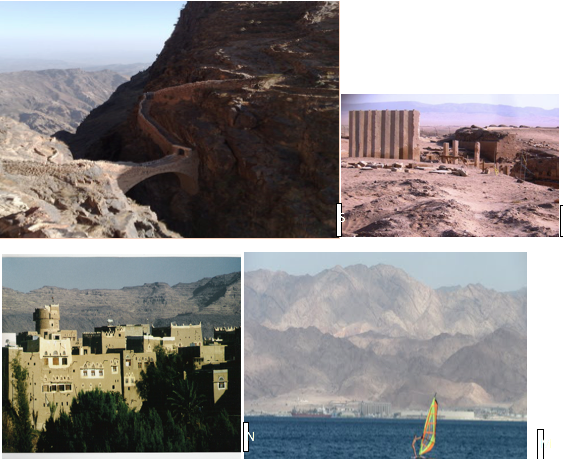
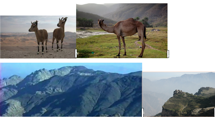
Here are some photos of the mountainous terrain along the route from Jerusalem to Bountiful, Oman:
Notice the descriptive language used in 3 Nephi 4:1 as Lehi and his followers coped with the mountainous terrain suggested by the preceding photos:
And it came to pass that in the latter end of the eighteenth year those armies of robbers had prepared for battle, and began to come down and to sally forth from the hills, and out of the mountains, and the wilderness, and their strongholds, and their secret places, and began to take possession of the lands, both which were in the land south [of the narrow strip of wilderness] and which were in the land north [of the narrow strip of wilderness], and began to take possession of all the lands which had been deserted by the Nephites, [as well as the Lamanites (see 3 Nephi 3:14 and 3 Nephi 6:2)] and the cities which had been left desolate. (Emphasis added.)
Now notice how Neville describes that scene:
These mountains are habitable; the robbers dwell “upon” them in hiding places. Yet they are in close proximity to the Nephite communities. The robbers can “sally forth” out of them, a term that means a sudden rushing out, as from a hiding place. . . These mountains would have to be in proximity to rivers, yet also in an area that supports extensive agriculture. . . The description in the text implies something more like “large hills” than “the largest eminences on the globe.” (See p. 210.)
These robbers were not “river pirates” hiding in caves (p. 210). These were not hills along the banks of a river but were large areas where armies had been training and living. And there were so many of the robber armies that they were able to occupy the lands and the cities of the Nephites and the Lamanites (3 Nephi 3:14) on both sides of the narrow strip of wilderness from whence the robbers had come (3 Nephi 3:17). These events were not happening from the Ohio/narrow-strip-of-water wilderness to Chattanooga, Tennessee—two hundred miles south and across the Tennessee River—to take over the city of Nephi! Nor were the robbers sallying forth from the Ohio—northwestward 250 miles—to take over the city of Zarahemla/Montrose! How much more illogical and invalid could Neville’s descriptions be worded?
These mountains, first mentioned in Helaman 11:25 in the year 13 BC, were the same mountains mentioned after the destruction at Christ’s crucifixion. That being the case, then they must have been the same mountains between the lands Zarahemla/Nephi that must have existed at the time when Mosiah I and those who followed him traveled through when they crossed the narrow strip of wilderness from Nephi and went down to the land of Zarahemla about 200 BC:
And it came to pass that he did according as the Lord had commanded him. And they departed out of the land into the [narrow strip of] wilderness, as many as would hearken unto the voice of the Lord; and they were led by many preachings and prophesyings. And they were admonished continually by the word of God; and they were led by the power of his arm, through the [narrow strip of] wilderness until they came down into the land which is called the land of Zarahemla. (Omni 1:13; emphasis added)
They were not sailing down the Ohio River as Neville would have us believe:
When Mosiah left the land of Nephi, he went “down” into the land of Zarahemla. (Omni 1:13) This means he went down river. Zeniff came “up” out of the land of Zarahemla; i.e., he went upstream. (Mosiah7:9) (p. 40)
That is not what the text says. Never are there any indications or questions in the New World about the use of these terms that are explained at the first of this section. For example, never is a sea confused with a river. A river is never deemed the major portion of a wilderness. The only means of travel or journeying mentioned was by foot. The New World Book of Mormon people generally never followed a river or used a river as the primary means of transportation—at least as far as described in the Book of Mormon itself. They knew and followed cardinal directions. When Mosiah went down out of the wilderness into Zarahemla, he came down out of the same mountains that were later occupied by the Gadianton robbers. In the interest of honesty and full disclosure to his brethren, Mormon and Moroni would have told their readers of any differences in meaning of these and other words than those that the ordinary reader would understand. There is no deception in the Book of Mormon.
II. Joseph Smith’s Understanding of the Geography of the Book of Mormon
The geography of the Book of Mormon began September 21, 1823, when the Angel Moroni appeared to seventeen-year-old Joseph Smith and told him that the gold plates contained a history of “former inhabitants of this continent.”
There is no question but that by 1830, Joseph Smith and most members considered the term “this continent” to mean North and South America. The belief was that the land southward described in the Book of Mormon was South America; the narrow neck of land was the Isthmus of Panama; and the Jaredite land northward was North America, with the hill “Ramah” located near Joseph’s home—which later became known as the Hill Cumorah. Joseph Smith never stated or maintained that this hemispheric understanding of the geography of the Book of Mormon was received by him by revelation. He never said that Moroni told him that Panama was the narrow neck of land or, for that matter, that the hill “Cumorah” was the same hill where the Jaredites were destroyed.
In his book, Letter VII,[6] Neville quotes the entire letter from Oliver Cowdery, which is the basis for the initial belief by Joseph Smith and others that the Hill Cumorah in upstate New York was the area of the last battles of the Nephites and Lamanites and also of the Jaredites. Oliver Cowdery did not claim that Moroni told him this fact. He did not claim that Moroni told Joseph Smith this fact either. Cowdery’s statements were clearly those that he personally believed in, and they were extrapolated from his understanding of his reading of the Book of Mormon—but not by revelation. In fact, Oliver Cowdery even declared that there was no current revelation about the Hill Cumorah being the place of those final battles:
Here may be seen, where once sunk to nought the pride and strength of two mighty nations, and here may be contemplated in solitude, while nothing but the faithful record of Mormon and Moroni is now extant to inform us of the fact, scenes of misery and distress. (See page 64 of Neville’s Letter VI: Oliver Cowdery’s Message to the World about the Hill Cumorah; emphasis added.)
There is no claim to revelation here. Cowdery is clearly relying on his reading of the record and not on statements from Moroni or revelation from the Lord. And until about 1842, Joseph assented to the theory that the hill in upstate New York was the hill Cumorah of the Book of Mormon, and Joseph even proposed various possible Book of Mormon locations in conformity with this belief, most of which are set out in Moroni’s America.
The foundational “pin” that I propose and adhere to is that if something is received by revelation from the Lord, then it was, and still is, true and will be supported by our current Prophet in The Church of Jesus Christ of Latter-day Saints. And because the Isthmus of Panama has been proven that it could not have been the narrow neck of land—and Neville and Meldrum agree with this proposition—then Joseph Smith’s initial beliefs about the geography of the Book of Mormon were clearly not by revelation, regardless of any statements to the contrary made by anyone. This conclusion, of course, must also include all geographical statements made by Oliver Cowdery, even if he was quoting the Prophet Joseph Smith himself.
The questions that must be answered are therefore the following: (1) Did Joseph Smith ever receive revelation that Panama was, or was not, the narrow neck of land? If so, when and where? (2) Did he ever receive revelation that Zarahemla was located in Guatemala? If so, when and where? (3) Did he ever receive revelation that the river Sidon was the Mississippi River? Or the river Grijalva? Or the river Usumacinta? If so, when and where? Did he ever receive revelation that the ancient city of Zarahemla was located near Montrose, Iowa? or Guatemala City (Kaminaljuyu)? or that the Hill Cumorah in New York was the same hill where the last battles of the Jaredites and Nephites/Lamanites were fought? If so, when and where?
Statements of belief are one thing. Revelation from the Lord through His authorized prophet is another.
Neville so much as admits on pages 321–323 that revelation as to the geography of the Book of Mormon has not been received. He cites statements from General Authorities as follows:
1. According to Anthony W. Ivins, “The Church says we are just waiting until we discover the truth” [about the geography of the Book of Mormon]. [7]
2. James E. Talmage said, “I encourage and recommend all possible investigation, comparison and research [about Book of Mormon geography] . . . But our brethren who devote themselves to that kind of research should remember that they must speak with caution and not declare as demonstrated truths points that are not really proved.”[8]
3. John A. Widtsoe added, “Out of the studies of faithful Latter-day Saints may yet come a unity of opinion concerning Book of Mormon geography.”[9]
4. Anthony W. Ivins further declared, “Where was the land of Zarahemla? Where was the City of Zarahemla? . . . There has never been anything yet set forth that definitely settles [those questions].”[10]
Until someone on behalf of the First Presidency of the Church can affirmatively state the answers to New World Book of Mormon geographic questions—with chapter and verse or by direct revelation through the current prophet—then it must be concluded that the answers must be in the negative and, therefore, the Prophet Joseph Smith never received revelation as to the geography of the Book of Mormon. Had he received such revelation, then there would be no conflict among believers as there is today.
The conclusion follows, therefore, that all of Joseph Smith’s geographic statements must have been based upon his personal beliefs at the time the statements were made. What necessarily follows from this conclusion is that all geographic statements made by anyone, even to the current date, are based on personal beliefs and not on revelation.
The Lord has not revealed the geographic location of the events of the Book of Mormon yet, undoubtedly for a wise purpose. The only exception to this is Moroni’s declaration that it took place “on this continent.” The prophecy about the new Jerusalem being located upon this land is not a geographical statement about where the Book of Mormon events took place but a prophecy about the future location of the New Jerusalem upon this continent.
III. Does the Text Control All Conflicting Geographic Statements?
One objective of the response to that question is to suggest that all writers and students of the Book of Mormon interested in this subject should study the Book of Mormon without reliance on any person’s statements or beliefs in its geography and then should rely exclusively on the text and any corroborating archaeological, geographical, and geological evidence. Even Rod Meldrum and Bruce Porter have stated the following:
- “Anything that Church authorities—including Joseph Smith—have said about ‘Book of Mormon geography’ is irrelevant if it conflicts with what is in the Book of Mormon itself.”[11]
- “Joseph Smith stated that the scriptures ‘say what they mean and mean what they say.’”[12]
In other words, if the Book of Mormon says “a sea,” it is a sea and not a river or a lake. If it talks about crossing a river, then it means on foot unless otherwise stated as when Lehi, the Jaredites, and the Mulekites crossed the sea in vessels. If it says “mountain,” it is more than just a large hill. If it says “wilderness,” it is not a river. If Mormon meant “a river,” he would have said “a river.”
Some Book of Mormon analysts claim that Joseph Smith stated that Zarahemla was located at Montrose, Iowa, as proposed by Neville as one of his “revealed” foundational “pins” (see p. 12). Other analysts claim that Joseph Smith wrote the articles in the Times and Seasons wherein he stated that Zarahemla was located in Guatemala. Whether Joseph Smith actually made such statements is irrelevant because they are geographic in nature and hence not made by revelation. As noted, Anthony W. Ivins even declared that the location of the city of Zarahemla had not been revealed (p. 321). And Oliver Cowdery said that “nothing but the faithful record of Mormon and Moroni is extant to inform us” of these geographic facts.[13] The conflict is irreconcilable. Therefore, the location of the city must be determined not from any such statements but from the text itself, and then it must be corroborated by valid physical evidence.
If one cannot affirmatively prove where Zarahemla was located, then does the Book of Mormon text give sufficient information to preclude specific areas from being Zarahemla? The answer is a resounding “Yes!”
IV. What Are the Parameters, from the Text, to Locate Where the City of Zarahemla Was Located or Where It Could Not Have Been Located?
According to the Book of Mormon itself, the city of Zarahemla must be located as follows:
1. West of the river Sidon (Alma 2:34; Alma 2:15).
2. Northerly of the city/land of Nephi (Alma 22:24, 27, Alma 50:7).
3. North of the land of Manti (Alma 17:1).
4. North of the narrow strip of wilderness (Alma 22:27).
5. Lower in elevation than the city of Nephi (Mosiah 28:1–7.
6. Northerly and lower in elevation than Gideon (Alma 62:7).
7. Northerly and lower than Minon (Alma 2:24).
8. Jershon and Antionum must be located east of Zarahemla and near the east sea (Alma 27:22, 31:3).
9. Jershon must be located down in elevation and east from the area near Manti, and east from Zarahemla (Alma 27:26).
10. The river Sidon must be fordable on foot near but south of the city of Zarahemla (Alma 2:27–34).
11. The river Sidon must be easily fordable on foot by large armies near the head of Sidon, which head must be located south of Manti, and Manti must be located south of Zarahemla (Alma 43, 44).
Any proposed location for the city of Zarahemla must conform to all of these conditions. Neville’s model possibly complies with 1, 2, 3, 4, 5, and perhaps 6 and 7, but it definitely does not satisfy the requirements of 8, 9, 10, and 11.
V. Was the Mississippi River Fordable on Foot?
One of the most significant features of Book of Mormon geography is the river Sidon. Thus, any model for Book of Mormon geography must reflect a major river.
As the proponents of the Heartland Model developed their Book of Mormon geography, they naturally realized the absolute necessity of identifying a river they could label as the river Sidon. In the setting for the Heartland Model, the territory from the Great Lakes on the north to the Gulf of Mexico on the south, the only possible candidate for the river Sidon was the Mississippi River, even though it flowed from north to south rather than south to north as had been stipulated for the river Sidon for the previous 170 years or so.
Readers of Neville’s Moroni’s America should be prepared to deal with issues associated with the Mississippi as the Book of Mormon’s primary river, the Sidon. Mesoamericanists agree that Book of Mormon warfare accounts associated with the Sidon “paint a clear picture” of the Sidon as a relatively shallow river at certain points so the warring parties could cross it on foot. If the Mississippi is the Sidon, analysts should naturally expect that it could be crossed on foot during Book of Mormon times. But was the Mississippi fordable on foot? A careful examination of the Sidon content of the Book of Mormon in relation to the geography and topography of the Mississippi answers that question.
A. (No. 10 above) The river Sidon Must Be Fordable on Foot near, but South of, the City of Zarahemla (Alma 2:27–34).[14] (See my article at endnote 14.)
If the city of Zarahemla was located near Montrose, Iowa, as proposed by Neville and supported by other proponents of the Heartland Model, then the Mississippi River—their river Sidon—must have been fordable on foot across the Des Moines Rapids as claimed by Rod Meldrum and Jonathan Neville. Meldrum stated the following in 2015:
We also know that the river between Nauvoo and Zarahemla was shallow enough to allow crossing on foot both anciently and in the Nauvoo period, making this one of the most strategic locations in North America.[15]
Neville agrees with Meldrum’s statement in an email sent to me on April 21, 2016: “Actually, the rapids here are the first place the River can be crossed on foot north of the Gulf of Mexico.”
There is no scientific or historical evidence to support this claim. No one has ever crossed the Mississippi on foot at the forty-five-hundred-feet-wide Des Moines rapids, including especially the thousands of soldiers who would have crossed it and fought in it on foot if the Mississippi were the Sidon. Those outcomes are an impossibility as explained in my short article entitled, “Crossing the Mississippi River on Foot,” a copy of which is located at endnote14. If the Mississippi River between Nauvoo and Montrose, Iowa, was crossable on foot, then why did Brigham Young not cross it on foot when the Saints left Nauvoo? Why did the Mormon pioneers always ferry people and wagons across the Mississippi? Or why did Brigham Young and the Saints wait until winter to cross the Mississippi on frozen ice when they first vacated Nauvoo?
The Army Corps of Engineers made the following statement regarding the Des Moines Rapids:
The difficulty of navigation . . . lies not so much in the shallowness of the channel or the thread of the current as in its unevenness of bottom, insufficient width [of the otherwise navigable chains of channels within the rapids], tortuous direction, and great velocity. The influence of those features is exaggerated by cross-surface and under currents, and by east and west winds.[16]
Alma 2 and 3 discuss the battle between the Nephites and the Amlicite/Lamanite armies and their crossing of the river Sidon several times on foot. Without a doubt, contrary to what Neville claims on page 151 of Moroni’s America, the Amlicite/Lamanite army did not “follow the Nephites into” the Mississippi (Sidon) river near Montrose, Iowa, or near Gideon—or anywhere in the Mississippi River for that matter (see Alma 2:24–27). At page 151, Neville states the following:
Because the Lamanites “came upon” the Nephites as the Nephites were crossing the river, the Lamanites had to be behind the Nephites, following them into the river (emphasis added).
This is his personal definition and is not what the scripture states or means. The synonyms for “come upon” as suggested in a thesaurus are “bump into,” “chance,” “encounter,” “meet,” and “come across,” none of which requires catching up from behind.[17]
Neville continues, “An interesting feature of the Mississippi River is the numerous islands that form in the channel. Here’s an example.” Neville then presents the following visual to his readers.
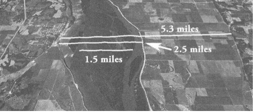
Following that visual, Neville says the following:
This section of the river, located just north of my proposed Gideon, is 2.5 miles wide at its widest point. What is now farmland to the east (right) of the current river is part of the historic channel, which is over five miles wide.
With this in mind, the description in Alma of a battle taking place while crossing the [Mississippi] river makes perfect sense. (See pages 151–53 of Moroni’s America.)
It makes perfect nonsense. Neville further stated in his email to me, “The Lamanite/Amlicite army was moving all night,” and “I think they were on the east side the entire time until the fight on the river.”
To Jonathan I say, “I am sorry but that analysis is, to use your word, ‘goofy.’” In this instance, that’s another way of reflecting the adjectives “unscholarly,” “illogical,” and “invalid” as I attempt to deal with his Mississippi River comments associated with pages 151–53 of Moroni’s America. Neville talks about the Mesoamericanists taking scriptures out of context and adding inferences that are not proper and so forth. However, his analysis in this instance is far more egregious than any he has cited of the Mesoamericanists. The Book of Mormon text absolutely does not say what he claims it means. And the events of Alma 2 absolutely could not have happened in the Mississippi River.
By his own admission in his email to me, he stated that the Des Moines “rapids here are the first place the River can be crossed on foot north of the Gulf of Mexico.” His proposed crossing of the Mississippi River, 2.5 miles north of his proposed Gideon, is located 23 miles south of the end of the rapids at Keokuk. Therefore, by his own admission, it is impossible to cross the Mississippi on foot, regardless of an island in the middle of it. Note also that there has never been an island or large sandbar in the middle of the Des Moines Rapids. Naturally, I recommend checking facts before making conclusions.
Neville further states the following on pages 152–53 (my comments are bracketed):
As I read this, Alma was crossing the river when the Lamanites attacked. The battle ensued on the river; i.e., on one of these islands in the middle of the river [the Book of Mormon does not say this]. Alma then cleared the west bank of the island [the Book of Mormon does not say this; it says “the bank which was [located] on the west of the river Sidon”—not west of an island] so his people could “have room to cross and contend with the [enemy] on the west side of the river” (Alma 2:34) This fits the text, which distinuishes beween “ground, or rather the bank, which was on the west of the river”—the ground Alma cleared—and the “west side of the river,” where Alma wanted to fight the battle. [This is Neville’s conjecture but not what the scripture says. How did the Lamanites/Amlicites ever get to the west bank of the Sidon ahead of Alma in the first place?]
The scripture says “when they had all crossed the river Sidon,” which I take to mean all the combatants, not just all the Nephites. [Neville might believe this, but the scripture does not say it.] Alma wisely saw that he had to lure the Lamanites to the west side; [does not say this] the last thing he would want is the Lamanites and Amlicites to return where they came from. [Why? Alma would have wanted them to go home rather than fight them.] Once he got them on the west bank, he could prevent them from returning home. Instead, he scattered them on the west and north. [All this is so much conjecture and guessing. Why not stick to what Joseph’s translation says?]
Just imagine that! About forty thousand Nephites, Lamanites—being so numerous they could not be counted (Alma 2:35)—and Amlicites all converging on foot that morning on an island in the middle of the Mississippi River and Alma “luring” Amlici and the Lamanites to the west side of the island—which did not exist in the rapids—so he could kill him and toss his body into the Mississippi River so that he could then climb upon the west bank of the river. Of course, he then had to help all the other combatant Lamanites out of the Mississippi River upon the west bank so he could then scatter them to the west and north to Hermounts! Neville should have written the Book of Mormon. His version is far more entertaining, and he apparently thinks he knows a lot more about the “facts” than Mormon did. Neville even knows where Alma wanted to fight the battle all along, not at Gideon, not on the island, but upon the west bank of the Mississippi—after they crossed the Mississippi and the island! The outcomes of Neville’s analysis are reflective of what he told me in his email about my explanations: “This is just goofy.”
And if Minon were located on the east side of the Mississippi 24 miles south of Gideon as claimed by Neville (153), what about all those fleeing farmers and their wives, children, and flocks. Did they also cross the 4,500 ft. wide Mississippi? On foot? And maybe even ahead of the Amlicites? Maybe the scouts did not have to tell Alma about the fleeing people from Minon because the people were fleeing ahead of the Lamanites and already had passed by Alma’s camp at Gideon. Why did Alma, instead of racing to beat the Amlicites to the city of Zarahemla, not stay in Gideon and, while his army was fresh, lay ambush against the Lamanites? The Amlicites would have been exhausted, having traveled and fought all the first day, fled twenty-four more miles to Minon by midnight, and then turned around and, during the night, marched back twenty-four miles to Gideon, according to Neville. Alma would have had a great tactical and strategic advantage. Why flee from them? Why not protect the fleeing farmers, wives, children, and flocks right there? Or another possibility, if the Lamanites/Amlicites were behind Alma by twenty-four miles, why did Alma not simply beat them to the river, cross the river, climb the west bank of the river, and then kill them as they attempted to climb out of the Mississippi?
What a bunch of “goofy” nonsense. Minon was located on the west side of river Sidon opposite Gideon. Let’s stick to the text of the Book of Mormon. And let’s stick to reality and the factual and historical impossibility of crossing the Mississippi on foot.
Therefore, the fact that the warring armies of Alma 2 were not able to have crossed the Mississippi on foot at the Des Moines Rapids results in the following outcomes: (1) the Mississippi River is not the river Sidon and (2) Montrose, Iowa, is not the city of Zarahemla.
B. (No. 11 above) The River Sidon Must Be Easily Fordable on Foot near Its Head as Required by Alma 43–44
According to the text of the Book of Mormon, the river Sidon must be readily fordable by a large army or group of people on foot near its head (see Alma 43–44). If we are to understand the nature of the battle in the valley of Manti and whether the river Sidon was fordable on foot in the area near the head of Sidon, a recitation of the applicable scriptures seems necessary—following which is a generic internal map of the area. The events are described in the Book of Mormon, with specificity and definiteness, as follows. Notice that Mormon distinguishes between a sea and a river and that the narrow strip of wilderness is different than a river (facts that will be discussed in the next section):
- All of the land of Nephi bordered from the sea on the east to the sea on the west and ran in a “straight course:”
[The king of the land of Nephi sent a proclamation to all his people throughout] “all his land who were in all the regions round about, which [all his land] was bordering even to the sea on the east and on the west, and which [all his land] was divided from the land of Zarahemla by a narrow strip of wilderness. [All of the king’s land of Nephi extended to the sea on the east and to the sea on the west.] (Alma 22:27)
And the land of Nephi did run in a straight course from the east sea to the west [sea]. [This is corroborated by Alma 22:27, 28, Alma 50:1).] (Alma 50:8, Alma 22:27–28).
The more idle part of the Lamanites lived in the [narrow strip of] wilderness, and . . . [they lived] on the west in the land of Nephi [must be south of the narrow strip of wilderness to be in the land of Nephi], in the place of their father’s first inheritance, and thus bordering along by the [west] seashore.” (Alma 22:28) [These scriptures corroborate that the land of Nephi extended all the way to both seas, contrary to what Neville claims (p. 50).]
- All of the narrow strip of wilderness ran from the sea east even to the sea west:
[The land of Nephi] was divided from the land of Zarahemla by a narrow strip of wilderness which [narrow strip of wilderness] ran from the sea east even to the sea west. . . . through the borders of Manti, by the head of river Sidon, [the narrow strip of wilderness did the dividing—not the land of Nephi—and it also ran from sea to sea, contrary to what Neville claims (p. 50)][18] running from the east towards the west—and thus were the Lamanites and the Nephites divided (Alma 22:27; emphasis added). [The narrow strip of wilderness ran from the sea east even to the sea west, and the valley of Manti and the head of Sidon were located within it. Therefore, the narrow strip of wilderness could not have been the Ohio River.]
Moroni created a defensive line within the narrow strip of wilderness between all of the land and people of Nephi and all of the land and people of Zarahemla:
[Captain Moroni] cut off all the strongholds of the Lamanites in the east wilderness, yea, and also on the west, fortifying the line between the Nephites and the Lamanites, between the land of Zarahemla and the land of Nephi, from the west sea, [the line] running by the head of the river Sidon—the Nephites possessing all the land northward [from the line] (Alma 50:11; emphasis added). [Therefore, Manti—located within the land of Zarahemla—must have been located north from the head of river Sidon because everything south of the line that went through near the head of Sidon was part of the land of Nephi. Everything north of that line within the narrow strip of wilderness from the sea east to the sea west was possessed, occupied, or controlled by the Nephites.]
- All of the greater land of Zarahemla extended from the same sea east to the same sea west:
This conclusion is corroborated by the following:
1. The narrow strip of wilderness divided all of the greater land of Nephi from all of the greater land of Zarahemla, and the wilderness extended from sea to sea.
2. Moroni chased all the Lamanites out of the east sea area to the south of the “line of possessions of the Lamanites”, which was either on the south side of or south of the narrow strip of wilderness (Alma 50:7, 9), and then the Nephites controlled and possessed all the land northward from Moroni’s line of defense from Zarahemla to the east sea.
3. Moroni, in the year 72 BC, then established control and possession on the west sea area (Alma 50:11) and “west sea south (Alma 53: 8)” and “in the borders of the land by the west sea (Alma 52:11, 12, 15, 18),” with Antipus and Helaman defending the area from Manti and the head of Sidon to the west sea (Alma 53:22, 52:11).
And thus he cut off all the strongholds of the Lamanites in the east wilderness, yea, and also on the west, fortifying the line between the Nephites and the Lamanites, between the land of Zarahemla and the land of Nephi, from the west sea running by the head of Sidon— the Nephites possessing all the land northward [from the line]. (Alma 50:11)
- The land of Antionum initially was part of the land of Zarahemla and bordered the east seashore—not a river “seashore” as proposed by Neville (p. 167):
Now the Zoramites had gathered themselves together in a land which they called Antionum, which was east of the land of Zarahemla, which [Antionum] lay nearly bordering upon the [east] seashore, which [Antionum] was south of the land of Jershon, [which Jershon was also located by the east sea] (Alma 31:3; emphasis added).
Jershon . . . is on the east [of the city Zarahemla from where the decision came to relocate the Ammonites] by the sea, which [Jershon] joins the land Bountiful, which [Jershon] is on the south of the land Bountiful (Alma 27:22). [This identifies the east sea and not a river as claimed by Neville (pp. 165, 169).]
Therefore, all travel between the land of Nephi and the land of Zarahemla and from the east sea to the west sea had to have passed through or crossed over the narrow strip of wilderness. That is what the Book of Mormon says, that is what it describes, and that is what it means, regardless of Neville’s machinations as he uses questionable chiastic combinations and semantic antics to justify the Ohio River being the narrow strip of wilderness and the Mississippi River being the west sea.A generic internal map of this area is helpful as we attempt to determine the two areas where the river Sidon was crossed on foot by armies—shown in dotted red circles: (1) at least five times near Zarahemla and (2) at least four times near the head of Sidon—between Manti and the head of Sidon—two by Alma and his army, one by Zerahemnah, and at least one crossing by the Lamanite army returning from destroying Ammonihah. There was another crossing, probably at the crossing near Zarahemla, by Zoram to intercept this army (see Alma:16: 6–7).
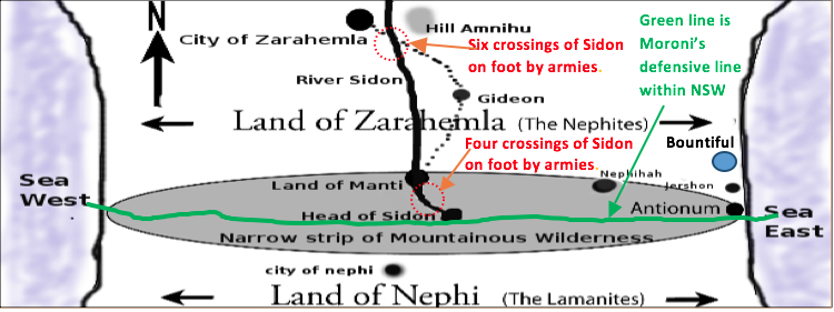
The preceding map shows the location of the battle near the head of river Sidon in the valley of Manti (Alma 43:25, 27, 31, 32, 35).[19] Hereafter, verses in parentheses in this section are from Alma 43 unless otherwise noted:
In 74 BC, Moroni was appointed chief captain of all the Nephite armies. He was stationed near the east sea coast in Jershon preparing for war with the Nephite dissenters and the Lamanites—including the Zoramites who had become Lamanites—who were “gathered together in the land of Antionum,” (15)—which also nearly bordered by the east seashore (Alma 31:3). Because the mostly naked Lamanites feared the armaments, breastplates, etc. of the Nephites, the Lamanites feared to go against them in the borders of Jershon. Their leader, Zerahemnah, decided to go into the narrow strip of wilderness (22) and “up” (34, Alma 56:25) to the area of the head of river Sidon (22)—which was located south of the city of Manti (Alma 50:1, 11)—and then “down” (32) into the land of Manti to “take possession” of it:
Behold, now it came to pass that they durst not come against the Nephites in the borders of Jershon; therefore they departed out of the land of Antionum into the [narrow strip of] wilderness, and took their journey round about in the wilderness, away by the head of the river Sidon, that they might come into the land of Manti and take possession of the land; for they did not suppose that the armies of Moroni would know whither they had gone (22; emphasis added). [They entered the land of Manti from the south by way of the head of Sidon, which was located “away up beyond Manti” (Alma 16:6).]
And it came to pass that the word of the Lord came unto Alma, and Alma informed the messengers of Moroni, that the armies of the Lamanites were marching round about in the wilderness, that they might come over [the area of the head of river Sidon from east to west because the land of Manti was located on the west side of river Sidon (see Alma 56:25)] into the land of Manti, that they might commence an attack upon the weaker part of the people (24).
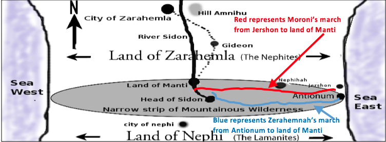
Moroni, with the help of spies (22) and prophetic advice from Alma (24), arrived in the valley where the land of Manti was located—which valley was also where the river Sidon was located (32)—ahead of Zerahemnah. Moroni then gathered the people in that area to help him fight the army of the Lamanites/Zoramites (25). He then divided this army into three groups. The main group was located west of Sidon but secreted within the wilderness and close to the west bank of the Sidon (27) and across from hill Riplah. The second group was headed by Lehi and was located on the east side of Sidon—across from where the main camp was hidden—and on the south side of a hill called Riplah (31), which hill was located on the northern part of the valley (34 and 22). The “remainder he concealed in the west valley, on the west of the river Sidon, and so down into the borders of the land Manti” (32; emphasis added). (This was not a different valley as claimed by Neville (171.)
Therefore, Lehi, Moroni’s main camp, the hill Riplah, and the place where Zerahemnah came into the valley near the head of Sidon were all located south of and up in elevation from the city/land of Manti near where the rest of the army was concealed.
The following generic map shows these approximate relationships and the locations where each battle occurred and where the river Sidon was crossed on foot at least three times by the various armies—all within the valley of Manti which was located north of and lower in elevation than the head of river Sidon. Both the head of river Sidon and the valley of Manti were located within the narrow strip of wilderness (Alma 22:27).
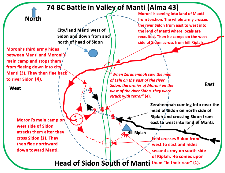
The additional scriptures in Alma 43 supporting the above are as follows:
27. And it came to pass that Moroni caused that his army should be secreted in the valley which was near the bank of the river Sidon, which [part of the valley] was on the west of the river Sidon in the wilderness.
28 And Moroni placed spies round about, that he might know when the camp of the Lamanites should come.
31. Therefore, he divided his army and brought a part over [river Sidon] into [the east part of] the valley, and concealed them on the east [of Sidon], and on the south of the hill Riplah; [the valley of Manti was located within the narrow strip of wilderness and the river Sidon split the valley. Hill Riplah was located on the east side of river Sidon. It was also located on the southern end of the valley because Zerahemnah came into the valley near the head of Sidon, which was located south of Manti. Lehi was hiding on the south side of the hill, and Moroni knew that the Lamanites were coming into the valley from the south from within the narrow strip of wilderness. When they entered the valley to take possession of Manti, they came in on the north side of Riplah because that was the path they took to cross Sidon and then go down into Manti, which was located north of the head of Sidon.]
32. And the remainder he concealed in the west valley, on the west of the river Sidon, and so down into the borders of the [city/] land Manti [therefore, not only was Manti located on the west of Sidon but also it was lower in elevation than the head of Sidon].
34. And it came to pass that the Lamanites came [from their march from Antionum] up on the north of the hill, where a part of the army of Moroni was concealed.
35. And as the Lamanites had passed the hill Riplah, and came [down; see verse 32] into the valley, and began to cross the river Sidon, the army which was concealed on the south of the hill, which was led by a man whose name was Lehi, and he led his army forth and encircled the Lamanites about on the east [of Sidon] in their rear.
36. And it came to pass that the Lamanites, when they saw the Nephites coming upon them in their rear, turned them about and began to contend with the army of Lehi.
37. And the work of death commenced on both sides, but it was more dreadful on the part of the Lamanites, for their nakedness was exposed to the heavy blows of the Nephites with their swords and their cimeters, which brought death almost at every stroke.
39. And it came to pass that the Lamanites became frightened, because of the great destruction among them, even until they began to flee [west] towards the river Sidon.
40. And they were pursued by Lehi and his men; and they were driven by Lehi into the waters of Sidon, and they crossed the waters of Sidon. And Lehi retained his armies upon the [east] bank of the river Sidon that they should not cross.
41 And it came to pass that Moroni and his army met the Lamanites in the valley, on the other side [west] of the river Sidon, and began to fall upon them and to slay them.
42. And the Lamanites did flee again before them, [down; see verse 32] towards the [city/] land of Manti; and they were met again by [the rest of the army that was protecting the city of Moroni] the armies of Moroni. [Manti was clearly lower than the head of Sidon.]
50. And they began to stand against the Lamanites with power; and in that selfsame hour that they cried unto the Lord for their freedom, the Lamanites began to flee before them; and they fled [east] even to [but not in] the waters of Sidon.
51. Now, the Lamanites were more numerous, yea, by more than double the number of the Nephites; nevertheless, they were driven insomuch that they were gathered together in one body in the valley, upon the [west] bank by the river Sidon.
52. Therefore the armies of Moroni encircled them about, yea, even on both sides of the river, for behold, on the east were the men of Lehi.
53. Therefore when Zerahemnah saw the men of Lehi on the east of the river Sidon, and the armies of Moroni on the west of the river Sidon, that they were encircled about by the Nephites, they were struck with terror.
54. Now Moroni, when he saw their terror, commanded his men that they should stop shedding their blood. (Alma 43:20–54; emphasis added)
The truth as contained in text of the Book of Mormon is that the river Sidon in the area of this battle in the year 74 BC was a small river that the armies could cross easily on foot. Moroni’s whole army crossed it from east to west before Zerahemnah arrived in the valley from the south. Lehi and the second army crossed the Sidon from west to east to hide on the south side of Riplah. Zerahemnah and his army crossed it from east to west and would have crossed back from west to east but for Lehi and his army on the east bank of Sidon. Zerahemnah could see them from the west bank.
To repeat, in one day, Zerahemnah came down with his army from the head of Sidon into the valley and fought Lehi on the east bank of Sidon. He crossed the river and fought Moroni on the west bank of Sidon and then fled down northerly toward city Manti—still in the valley of Manti where they were engaged the third time—where he was “met again by the armies of Moroni.” The fighting stopped for a while because they were trapped on the west bank of the Sidon and were surrounded on both sides of the river Sidon. Moroni tried to negotiate a peace with Zerahemnah. This failed, and the battle continued until Zerahemnah finally gave up.
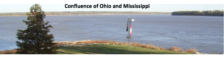
How could all of these events have happened anywhere on the Mississippi—especially at or near the confluence of the Ohio and/or Missouri and Mississippi rivers? Neville claims these crossings occurred near Afton, Il. near modern St. Louis (172). How could the events have happened in one day anywhere unless the river Sidon was not a huge river near its head and was shallow enough for easy crossing as it must have been near its beginning? How could Zerahemnah have seen Lehi and his men standing on the east bank of the Mississippi? For emphasis, look at a photo of the confluence of the Ohio and Mississippi Rivers and see how impossible it would have been for the battle in the valley of Manti to have happened here.
Rod Meldrum disagrees, without citing a single scripture in support, saying:
To recap: The Sidon River in the Book of Mormon flowed past Zarahemla southward and “down” toward Manti which was at the head or confluence. . . The “headwaters” could refer to the confluence of present-day Missouri and Mississippi rivers.[20]
Meldrum has it exactly backwards. According to the Book of Mormon, Manti must have been located at a higher elevation than Zarahemla. Otherwise, why did the Lamanites “durst not march down against the city of Zarahemla” from near Manti? (Alma 56:14, 25) By Neville’s and Meldrum’s own admissions, Manti/Huntsville was located a hundred miles west and north of the confluence of the Missouri and Mississippi rivers instead of at the head. The text says that the river Sidon flowed from its head “down,” and therefore “northward,” toward Manti—not southward—and then it flowed northward past Zarahemla. It also says that the head of Sidon was located “away up beyond the borders of Manti” (Alma 16:6).
Actually, Neville agrees that there was a north-flowing river, but it went “through the land of Nephi to the land of Zarahemla”:
So the notion that there is a north-flowing river is correct but it’s not the Sidon River. Translated into the modern world, the Sidon is the Mississippi, and the river flowing up and south to the land of Nephi is the Tennessee River.” (See page 284.)
Nowhere does the text say or mean that the river Sidon flowed “past Zarahemla southward and ‘down’ toward Manti.” This thinking is pure fabrication.
It is his “revelation translation.” It is not what the Book of Mormon says. Look at the confluence of the Mississippi with the Missouri and also near Afton, Illinois where Neville claims they crossed:
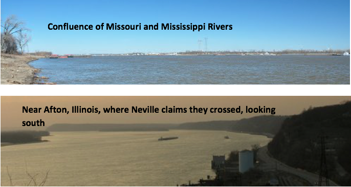
Think for a minute or so about the possibility of crossing this on foot. Impossible! And yet, incredibly, Neville claims that this was the place where this battle took place, saying:
All of this was taking place near the “head of Sidon,” because that is where the Lamanites planned to attack. The passage describes a river that is a significant barrier, with a hill and bank on the east side and a large valley on the west side. Armies can cross it (at least at some times of the year) but it is a significant barrier. This cannot be “headwaters” as some commentators have proposed. Another requirement; there must be a way out of the valley toward the land Manti. One place that fits this description nicely is where the Missouri River meets the Mississippi. (See pp. 171–72.)
Really! Where does any scripture say that the head cannot be the source of the river Sidon? And again really! Zerahemnah and his army came from the east sea and crossed this humongous Mississippi/head-of-Sidon area to go “down” over a hundred miles northerly to the land of Manti/Huntsville? Neville’s word “goofy” aptly describes such thinking, which, as noted previously, could also be described by such expressions as “unscholarly,” “illogical,” and “invalid.”
Neville can’t quite determine where the head of Sidon/Mississippi really began, saying at page 279:
The phrase “head of Sidon” cannot mean the source, but instead means the confluence of rivers. Figure 78 illustrates where the Mississippi joins the Missouri and Ohio Rivers. The Illinois River joins just north of the Missouri River. Somewhere in that area, or perhaps the entire section from the Missouri to the Ohio River, is the head of Sidon.
The truth from the text of the Book of Mormon is that the river Sidon began at its head located “away up beyond Manti” (Alma 16:6) in the southern part of the narrow strip of wilderness and flowed north down past Manti and then continued northerly down past Zarahemla.
This truth is confirmed by the fact that the river Sidon was easily fordable near its head, whereas the Mississippi River was not.
If the Mississippi river was so fordable on foot, then why did the 150-man Zion’s March have to be ferried across, not only the much smaller Illinois River—2,500 feet wide—but also the huge Mississippi River into Missouri:
Our enemies had threatened that we should not cross the Illinois River, but on Monday the 2nd [June 1834] we were ferried over without difficulty. . . Our true number was about one hundred and fifty [June 4 and 5] …On the 4th, we encamped on the banks of the Mississippi river. . . The river being a mile and a half wide, and having but one ferry boat, it took two days for us to pass over.[21]
Maybe the Nephites and Lamanites had thousands of ferry canoes at the ready to ferry their innumerable armies across the Mississippi River. Or, as Neville suggested, maybe they just “waded or swam across” (p. 41). Neither Meldrum nor Neville cite any scientific or historical evidence that the Mississippi River was fordable on foot at these locations. Therefore, the most logical conclusion that should be stated at this point is that the Heartland Model is fatally flawed.
C. In 81 BC, There Were Two More Crossings of the River Sidon on Foot by Marching Armies.
After the Lamanites had destroyed Ammonihah and taken prisoners from Noah, they were returning to the land of Nephi. Alma inquired of the Lord as to where the Nephites could intercept the Lamanites and save their brethren. The scriptures tell the story:
And it came to pass that Alma inquired of the Lord concerning the matter. And Alma returned and said unto them: Behold, the Lamanites will cross the river Sidon in the south wilderness, away up beyond the borders of the land of Manti. And behold there shall ye meet them, on the east of the river Sidon, and there the Lord will deliver unto thee thy brethren who have been taken captive by the Lamanites.
And it came to pass that Zoram and his sons crossed over the river Sidon, with their armies, and marched away beyond the borders of Manti into the south wilderness, which was on the east side of the river Sidon. (Alma 16:6–7; emphasis added)
The Lamanite army with their captives all crossed the river Sidon—about the same place as Zerahemnah had crossed it— “away up beyond the borders of the land of Manti.” This was the description of the area of the head of Sidon, and it was clearly up in elevation above the land of Manti. And because the head of Sidon was south of Manti, then the river Sidon must have flowed northward from its head. However, the direction of the flow of the river Sidon is not the main point of this article. The main point is the fact that the river Sidon was easily crossable on foot by an army or large group of people between the head of Sidon and Manti.
Zoram and his armies crossed it from west to east, probably just south of Zarahemla—where a crossing seemed to exist to go into the land of Gideon—from where they were sent to recover their captured Nephites. The Lamanite army and captives crossed it from west to east, “away up beyond Manti”—again demonstrating how the Nephites and Lamanites could easily cross the river Sidon on foot near its head.
Neville admits that the Mississippi River was easily crossable, saying:
When Zoram and his sons crossed over the river Sidon with their armies in Alma 16:7, they could have waded, swam, or used boats. They could have even constructed a bridge. (See page 41.)
And they could have even used helicopters! Neville talks about the Mesoamericanists “distorting the text to fit their theory” (272). Moroni’s America is full of distortions. Why did Brigham Young not just build a bridge or have the Saints wade across the Mississippi?
If Zarahemla was Montrose, Iowa, and if the head of Sidon was the confluence of the Ohio and Mississippi rivers, then these two crossings would have to have been between these two locations, and that is and was an impossibility.
Because Neville and Meldrum both admit that the Mississippi River was never fordable on foot south of the Des Moines Rapids and because at least four of the above crossings had to have occurred south of these rapids between Huntsville/Manti and Cairo/head of Sidon, then the river Sidon cannot be the Mississippi River and the corollary to that is that Montrose, Iowa, cannot be the city of Zarahemla of the Book of Mormon.
The truth and the proof are that the Mississippi is not, was not, and could not have been the river Sidon. Therefore, Neville’s reliable “pin”—city of Zarahemla being located on the west side of the Mississippi across from Nauvoo—is, once again to use Neville’s term, “goofy.”
VI. Was the narrow strip of wilderness that extended “from the sea east even to the sea west” a series of rivers—the Ohio, Mississippi, and Missouri Rivers? Or was it a terrestrial area including a series of mountains?
Most students of the Book of Mormon have agreed that the narrow strip of wilderness involved some sort of terrain. Neville has created a very novel and creative claim that, in fact, it was a series of rivers including all of the Ohio and all of the Missouri and the Mississippi between those confluences (see page 279). I have studied his theory and have not stopped wondering in amazement at his semantic ingenuity and his willingness to throw out the words “sea,” and “wilderness” as used by Mormon, Moroni, and Joseph Smith, replacing them with “rivers.” The common meaning of sea is defined as follows in the 1828 Webster’s Dictionary:
A large body of water, nearly inclosed by land, as the Baltic or the Mediterranean; as the sea of Azof. Seas are properly branches of the ocean, and upon the same level. Large bodies of water inland, and situated above the level of the ocean, are lakes. The appellation of sea, given to the Caspian lake, is an exception, and not very correct. So the lake of Galilee is called a sea, from the Greek.
And the word wilderness was used by Nephi, Mormon, and Moroni as follows:
“Wilderness” is used to refer to areas that included deserts, forests, and mountains. Lehi departed from Jerusalem “into the wilderness” and “traveled in the wilderness in the borders which are nearer the Red Sea” (see 1 Nephi 2:4–5). He even lived in the wilderness (7:5). Thus, “wilderness” is not defined as an uninhabited river as claimed by Neville (p. 52).
There is no evidence of any of these prophets ever applying the term “sea” to a river in the Book of Mormon. Neville makes the claim that Joseph Smith “could have” referred to the sea as a “mighty River” (p. 34) and that Mormon “could have described it [the mighty river] as a sea” (p. 35). Is this the new way of describing a revelation with the subjunctive “could have?”
There is also no evidence that these prophets ever applied the term “wilderness” to a river.
Neville also changes the usage of the words “up” and “down” to mean following the current of the river:
When I read the text, I usually think of upstream when I read up, and downstream when I read down. When Mosiah left the land of Nephi, he went “down” into the land of Zarahemla. (Omni 1:13) This means he went downriver. Zeniff came “up” out of the land of Zarahemla; i.e., he went upstream. (Mosiah 7:9; see p. 40)
Next, Neville erroneously redefines Alma 22: 27 by saying that the term “from the sea east even to the sea west” need not mean all the way to the sea for the narrow strip of wilderness:
It is the territory of the Lamanites, not the narrow strip of wilderness, that extends from the sea east to the sea west [wrong]. This suggests that the border—the narrow strip of wilderness—may not be extend[ed] all the way to either sea. (see p. 50; emphasis and insert added)
Those are all interesting conjectures. However, an oft-repeated statement represents a valid conclusion here: “That is not what the text says.” Neville has to change to these new ways of looking at the use of “sea,” “wilderness,” “up” and “down,” and “which” to support his proposal that the narrow strip of wilderness was a “major river—or system of rivers—that serves as an effective border”:
The “narrow strip” element suggests a feature that is visible and obvious to people on the ground; i.e., narrow enough that observers can see how wide it is, and long and thin enough that it is not mistakable. It is a definite border not a vague region. Narrow suggests a vale, valley, or river bed. Strip suggests something that is long and thin—like a river. . . Wilderness indicates the feature is uninhabited. A river cannot be inhabited. (p. 52)
By combining all of these “new way revealed” definitions, Neville somehow establishes that the narrow strip of wilderness of the Book of Mormon was not a land area but a combination of the Ohio, Missouri, and Mississippi Rivers (see pp. 19–20) with the head of the river Sidon being the confluence all three of these rivers—plus maybe the Illinois river. He further divines that the lower Mississippi—from its head at Cairo—was, in fact, the west sea. Such reasoning is astonishing at the very least.
Or, if we were to use Neville’s expression for invalid thinking, “This is sheer ‘goofiness.’” It is certainly not what the Book of Mormon says. The first part of verse 27 clearly defines the land of Nephi as extending to both seas. Then, it specifically says that the land of Nephi “was divided from the land of Zarahemla by a narrow strip of wilderness which [narrow strip of wilderness] ran from the sea east even to the sea west.” How much more clear can it be? Moroni’s military dividing line—border or wilderness—went from the sea east even to sea west; the land of Nephi went from same sea east to the same sea west; and the land of Zarahemla went from the same sea to sea. That is what it says, and that is what it means.
It further says that the “idle Lamanites” “lived in and were spread through” that narrow strip of wilderness, not in a river. The land of Moroni was also located within the narrow strip of wilderness and not in a river. The head of Sidon was located within the same narrow strip of wilderness just above and south of where the valley of Manti was located.
The end result seems to be an incredibly tortuous twisting of unreasonable definitions to suit Neville’s purposes. Neville’s own oft-repeated words have direct applications here: (1) “This is purely an inference designed to fit a theory of” North American geography (see p. 49); (2) “That is not what it says,” and (3) “Let’s stick to the text.”
If the Ohio River was the narrow strip of wilderness, as suggested by Neville, and if it dried up occasionally but was still a border dividing the land of Nephi from the land of Zarahemla, then why did the Nephites and the Mulekites not discover each other for 350 years—from about 588 BC to 200 BC, as required by the Book of Mormon? All they had to do was walk across the “thin,” “narrow,” and “sometimes dry” riverbed—and there they were!
The Ohio River might have been a border, but it certainly was not a barrier for 350 years, as required by the Book of Mormon. The historical evidence shows that the Woodland people were a federation of riverine trading partners starting in Ohio and spreading throughout the eastern half of the United States starting about 200 BC and continuing to well past AD 500. The areas of Zarahemla/Montrose, Iowa, and Nephi/Chattanooga, Tennessee, were certainly not unknown to the Hopewell people for about 350 years, as required by the Book of Mormon. And if the Ohio River was that narrow strip of wilderness, why did it not extend to the Atlantic/east sea as required by the text? The Atlantic Ocean is one of Neville’s three east seas (36, 265, 164–65).
At this point, we should remember the defining scripture in Alma 22:27 that says that the land of Nephi was “divided from the land of Zarahemla by a narrow strip of wilderness which ran from the sea east even to the sea west.” It ended at the sea west. It did not go beyond the west sea. Nothing in the Book of Mormon went beyond the west sea.
Then why did the narrow strip of wilderness not stop at the Mississippi river, which is Neville’s west sea, as required by the text? Why did the narrow strip of wilderness keep going first north—instead of east to west—up the Mississippi river for 150 miles to the Missouri River where it turned and then continued northwest for 2,200 miles to the Rocky Mountains? Were the Rocky Mountains also the sea west? If the Missouri was also the narrow strip of wilderness, why did it not end at the west sea, as required by the Book of Mormon? But then on page 170, Neville does show the Mississippi as also the “east sea” where Jershon was located on the east by the sea. Wow! The Mississippi River was the west sea, the east sea, the narrow strip of wilderness, and the river Sidon! And the confluence of the Ohio was also the head of the river Sidon and was easily crossable on foot!
That is “revelation,” but it does not come from the Book of Mormon! And it does not come from the Lord because if it did, our current Prophet would tell us.
Conclusion
A further example of Neville’s confusing smoke screen of plausible interpretive revelation is his construction of the simple phrase in Alma 22:28: “and thus the land of Nephi and the land of Zarahemla were nearly surrounded by water.” Without explaining why, he merely concludes, “Here is my proposal for how the two lands were each nearly surrounded by water” (emphasis added). He then proceeds to show how each was separately surrounded by rivers, lakes, and ocean with the Ohio River being the narrow strip of water wilderness that was supposed to go from the sea east to sea west—but did not— being the water border between these two lands (see p. 58). And these two areas that were separately surrounded by water encompass an area that included more than the entire eastern half of the United States extending from the northern Rockies to Canada, down the Missouri, the Mississippi, the Gulf of Mexico, the Atlantic, and over to Lake Ontario. And Mormon could see all of that because he was looking at it from a satellite! For me personally, no thank you. The Mississippi River was not the river Sidon; Montrose, Iowa, was not the Book of Mormon site of Zarahemla; The hill Cumorah in New York was not the place of the final battles described in the Book of Mormon.
The locations of the events of the Book of Mormon have not been revealed. I hope every student of the Book of Mormon will not rely on statements of belief from Neville or Meldrum or the Allens or Magleby or anyone’s statements of belief, including my own. If anyone is really interested in the nonessential understanding of the geography of the Book of Mormon, then each person should independently determine its location from the light the Book of Mormon sheds on its own geography for their personal benefit and not try to impose it on others and profit from it through selling books, tours, artifacts, conferences, etc.
I love the Book of Mormon and know it is a true and faithful account of what it purports to be. I know this by personal revelation to me, and I pray each person will strive for his or her own personal revelation in a like manner. I share my personal understanding of the geography of the Book of Mormon for the purpose of exposing where some theories directly violate what the Book of Mormon plainly states. I do it without financial reward of any kind, and I will never financially benefit from anything dealing with the Book of Mormon. It is true regardless of the disharmony and dissension that exist within the Mormon community regarding its geography.
Notes
[1]. Jonathan Neville, Moroni’s America: The North American Setting for the Book of Mormon (n.p.: Digital Legend, 2015), xi.
[2]. Jonathan Neville, Letter VII: Oliver Cowdery’s Message to the World about the Hill Cumorah (n.p.: Digital Legend, 2015).
[3]. Emphasis added. All page numbers in parentheses in this article refer to Moroni’s America unless otherwise noted, and all Book of Mormon quotations are shown in italics.
[4]. “Introduction,” The Book of Mormon: An Account Written by the Hand of Mormon upon Plates Taken from the Plates of Nephi (Salt Lake City: The Church of Jesus Christ of Latter-day Saints, 1981).
[5]. Larry E. Dahl and Donald Q. Cannon, eds., Encyclopedia of Joseph Smith’s Teachings (Salt Lake City: Bookcraft, 1997), under “Scriptures.”
[6]. Jonathan Neville, Letter VII (Salt Lake City: Digital Legend, 2016).
[7]. Anthony W. Ivins, Conference Report, April 1929, 16; Neville, Moroni’s America, 321.
[8]. James E. Talmage, Conference Report, April 1929, 44; Neville, Moroni’s America, 321; emphasis added.
[9]. John A. Widtsoe, “Evidences and Reconciliations: Is Book of Mormon Geography Known?” Improvement Era 53, July 1950, 547; John L. Sorenson, Mormon’s Map (Provo, UT: The Foundation for Ancient Research and Mormon Studies, 2000), 7; Neville, Moroni’s America, 322.
[10]. Ivins, Conference Report, April 1929, 16; Neville, Moroni’s America, 321; emphasis added.
[11]. Quotation attributed originally to John L. Sorenson but endorsed by Bruce Porter and Rod Meldrum, Prophecies and Promises: The Book of Mormon and the United States of America (Mendon, NY: Digital Legend, 2009), 2.
[12]. Porter and Meldrum, Prophecies and Promises, 126.
[13]. Neville, Letter VII, 64.
[14]. Here is the text of a short article I wrote entitled “Crossing the Mississippi River on Foot”:
Just swimming across the Mississippi river is a dangerous and foolish matter. Many try; few succeed in their foolish attempts to swim the Mississippi. (See Patrick B. Anderson, “Many Try, Few Succeed in Foolish Attempts to Swim River,” August 25, 2012, http://lacrossetribune.com/news/local/many-try-few-succeed-in-foolish-at... [accessed May 26, 2016].)
In spite of the evidence that few swimmers, even strong ones, can successfully swim the Mississippi, Rod Meldrum claims that the Mississippi river could easily have been crossed on foot at the Des Moines Rapids.
Could the Mississippi River be crossed on foot, and are its banks sufficient to allow battles to be held on them?
Remember that the Mississippi today is much wider and deeper than it was in the days before dams, locks and levies, making it still a large river, but much more shallow. In fact, the river at Nauvoo was actually shallow enough to cross on foot! This area was called the Des Moines rapids and riverboats had to off-load their cargo to pass these rapids prior to the building of locks/dams across the river. The Des Moines Rapids are known historically to have been less than 2.4 feet deep, making this the first location upstream from the Gulf of Mexico where the mighty Mississippi could be crossed on foot! Certainly this would make this area a strategic location for any ancient civilization, as access to both sides of the river was easily attainable. (See Rod Meldrum, “The Mississippi; Could It Have Been River Sidon?” The Firm Foundation, June 4, 2010, http://www.firmlds.org/feature.php?id=14 [accessed May 26, 2016].)
But not on foot! With the exception of crossing the river when frozen over, there is no evidence that I can find of anyone, even native Americans, who crossed the Mississippi River on foot. Certainly access to both sides of the Mississippi river in this area was never “easily attainable” and then only by boat. The above claim by Meldrum is baseless and without any corroboration.
For thousands of years, the mighty Mississippi—because of its phenomenal volume of water and annual flooding—has changed course many times:
Timeline of outflow course changes:
c. 5000 BC: The last Ice Age ended; world sea level became what it is now.
c. 2500 BC: Bayou Teche became the main course of the Mississippi.
c. 800 BC: The Mississippi diverted farther east.
c. AD 200: Bayou Lafourche became the main course of the Mississippi.
c. AD 1000: The Mississippi’s present course took over.
It is common knowledge that almost every year for the past thousands of years there has been some kind of a flood on the Mississippi, and each flood has left boulders, trees, sandbars, and debris scattered in the river, making navigation of the river ever more dangerous.
Rod Meldrum fails to recognize this and further fails to apprise his readers of the following statement on page 278 of his above-referenced report by the Army Corps of Engineers regarding crossing the Des Moines Rapids:
The difficulty of navigation lies not so much in the shallowness of the channel or the thread of the current as in its unevenness of bottom, insufficient width [of the otherwise navigable chains of channels within the rapids], tortuous directions and great velocity. The influence of those features is exaggerated by cross surface and under currents and by the east and west winds. (See Report of the Chief of Engineers, U.S. Army, by United States Army Corps of Engineers, https://books.google.com/books.)
Neville agrees with Meldrum’s statement in an email sent to me on April 21, 2016:
Actually, the rapids here are the first place the River can be crossed on foot north of the Gulf of Mexico. The photo below is a modern scene, the result of the dam and lock system. The average depth of the Mississippi before the dam was 2.4 feet, meaning it was even more shallow in the summer. I recommend checking facts before reaching conclusions.
He is correct about the photo of the Mississippi near Keokuk that I had attached to my article, “Book of Mormon Objective Geographic Standard No. 1.” I thank him for bringing that to my attention and have deleted it from my article as it is anachronistic. However, he is not correct in the following conclusions: (1) that travelers could have crossed the Des Moines Rapids on foot, (2) that the Amlicites fought the Nephites in the Mississippi River, or (3) that the Amlicite/Lamanite armies followed the Nephites into the river. No one has ever fought a battle on foot in the Mississippi River. That the Amlicites and Lamanite armies were located on the west bank of the river Sidon that second day is sure. That they tried to keep Alma and the Nephites in the river Sidon is also sure because that is what the scripture says. But that this could have happened in the Mississippi River is totally, to use Neville’s word about parts of my article, “goofy” (a less-than-scholarly synonym for “unscholarly,” “illogical,” or “invalid”).
The following is a description in 1870 of the difficulty of crossing the Mississippi River at the Des Moines Rapids in a boat, let along on foot. These rapids started at Montrose, Iowa, and ended eleven miles downriver near Keokuk, Illinois.
The fall in eleven miles is twenty-two feet; average width of Mississippi river, four thousand five hundred feet; its mean depth, two and four-tenths feet; and its mean surface velocity is two and eighty-eight hundredths feet per second. The tortuous, uncertain channel over these rapids precludes the possibility of any craft navigating them in low water. Even if the channel itself was wide and deep, no pilot would dare to undertake to pass them at night. (See J. E. Griffith, “The Des Moines Rapids of the Mississippi River, and Its Improvements,” The Annals of Iowa, 1870, No. 2 [1870], 149–54.)
The forced removal of Native Americans from the eastern part of the United States during the infamous Trail of Tears march shows the treacherousness of crossing of the Mississippi near the area of Nauvoo. They did not cross on foot but were ferried across the Mississippi:
Two thirds of the ill-equipped Cherokee that were trapped beside the frozen Mississippi River still remembered a half-century later the hundreds of sick and dying in wagons or lying on the frozen ground with only a single blanket provided by the government to each Indian for shelter from the cold wind. Falling temperatures caused the surface of the river to freeze before all the detachments could be ferried across. The ice prevented both boat and horses from moving. Besides the cold, there was starvation and malnutrition. Weakened by the hunger, the Cherokee became easy victims of disease, particularly cholera, smallpox and dysentery. Many died on both sides of the river waiting for [the] journey to resume. (See “Trail of Tears Across the Mississippi Valley,” http://www.univie.ac.at/Anglistik/webprojects/LiveMiss/TrailofTears/trai... [accessed May 26, 2016].)
Crossing the Mississippi River on foot anywhere, at any time—except perhaps near its headwaters in Minnesota and except when the Mormons crossed it on foot when it was frozen over—was impossible. Without a doubt, contrary to what Neville claims on page 151 of his book, Moroni’s America, the Amlicite/Lamanite army did not “follow the Nephites into” the Mississippi/Sidon river near Montrose, Iowa, or near Gideon—or anywhere in the Mississippi River for that matter. At pages 151–53, Neville says, “Because the Lamanites ‘came upon’ the Nephites as the Nephites were crossing the river, the Lamanites had to be behind the Nephites, following them into the river” (emphasis added).
There is no such definition of the term “came upon.” This is his personal definition and is not what the scripture states or means. The synonyms suggested in a thesaurus are “bump into,” “chance,” “encounter,” “meet,” “come across,” all of which do not require catching up from behind.
Neville continues:
An interesting feature of the Mississippi River is the numerous islands that form in the channel. Here’s an example.
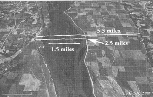
This section of the river, located just north of my proposed Gideon, is 2.5 miles wide, from bank to bank. The island in the channel is about 1.5 miles wide at its widest point. With this in mind, the desription in Alma of a battle taking place while crossing the [Mississippi] river makes perfect sense. (See Jonathan Neville, Moroni’s America: The North American Setting for the Book of Mormon (n.p.: Digital Legend, 2016), 151–53.)
Neville further stated the following in an email to me “The Lamanite/Amlicite army was moving all night,” and “I think they were on the east side the entire time until the fight on the river.” He later said of my statements, “Why don’t we stick to the text.”
I am sorry, Jonathon, but that statement is, to use your word, “goofy.” It makes about as much sense as the Heartland geographic model claiming that all events described in the Book of Mormon ocurred exclusively in the Eastern United States. (I am not talking about the completion of prophesies and promises to the covenant English Gentiles upon the most favored nation—the United States—among other nations the Lord promised He would establish on “this continent, North and South America”).
Neville talks about the Mesoamericanists taking scriptures out of context and adding inferences that are not proper and so forth. This one of his is far more egregious than any he has cited of the Mesoamericanists. The text absolutely does not say what he claims it means. And the events absolutely could not have happened in the Mississippi River.
By his own admission in his email to me, he stated that the Des Moines “rapids here are the first place the River can be crossed on foot north of the Gulf of Mexico.” His proposed crossing of the Mississippi River, 2.5 miles north of his proposed Gideon, is located 23 miles south of the end of the rapids at Keokuk and therefore, by his own admission, impossible to cross the Mississippi on foot, regardless of an island in the middle of it. Note also that there has never been an island or large sandbar in the middle of the Des Moines Rapids. “I recommend checking facts before making conclusions.”
Neville further states the on page 152:
As I read this, Alma was crossing the river when the Lamanites attacked. The battle ensued on the river; i.e., on one of these islands in the middle of the river [does not say this]. Alma then cleared the west bank of the island [does not say this. It says “the bank which was (located) on the west of the river Sidon” not west of an island] so his people could “have room to cross and contend with the [enemy] on the west side of the river” (Alma 2:34). This fits the text, which distinguishes beween “ground, or rather the bank, which was on the west of the river”—the ground Alma cleared—and the “west side of the river,” where Alma wanted to fight the battle. [This is his conjecture but not what the scripture says. How did the Lamanites/Amlicites ever get to the west bank of the Sidon ahead of Alma in the first place?]
The scripture says “when they had all crossed the river Sidon,” which I take to mean all the combatants, not just all the Nephites, [Neville might believe this, but the scripture does not say it] Alma wisely saw that he had to lure the Lamanites to the west side; [does not say this] the last thing he would want is the Lamanites and Amlicites to return where they came from. Once he got them on the west bank he could prevent them from returning home. Instead, he scattered them on the west and north. [All this is so much conjecture and guessing. Why not stick to what Joseph’s translation says?]
Just imagine that! About forty thousand Nephites, Lamanites—so numerous they could not be counted (Alma 2:35), and Amlicites all converging on foot that morning on an island in the middle of the Mississippi River and Alma “luring” Amlici to the west side of the island—which did not exist in the rapids—so he could kill him and toss his body into the Mississippi River so that he could then climb upon the west bank of the river. Of course, he then had to help all the other combatant Lamanites out of the Mississippi River upon the west bank so he could then scatter them to the west and north to Hermounts! Neville should have written the Book of Mormon. His version is far more entertaining, and he knows a lot more about the “facts” than Mormon did. He even knows where Alma wanted to fight the battle all along—not on the island but upon the west bank of the Mississippi—after they crossed the Mississippi and the island! Like Neville told me in the email “This is just goofy.”
And what about all those fleeing farmers and their wives, children, and flocks. Did they also cross the Mississippi—maybe even ahead of the Amlicites? Maybe the scouts did not have to tell Alma about the fleeing people from Minon because the people were fleeing ahead of the Lamanites and already had passed by Alma’s camp at Gideon. Why did Alma, instead of racing to beat the Amlicites to the city of Zarahemla, not stay in Gideon and, while his army was fresh, lay ambush against the Lamanites? The Amlicites would have been exhausted, having traveled and fought all the first day, fled twenty-fur more miles to Minon by midnight, and then turned around and, during the night, marched back twenty-four miles to Gideon, according to Neville. Alma would have had a great tactical and stratigic advantage. Why flee from them? Why not protect the fleeing farmers and their wives right there? Or another possibility, if the Lamanites/Amlicites were behind Alma by twenty-four miles, why did Alma not simply beat them to the river, cross the river, climb the west bank of the river, and then kill them as they attempted to climb out of the Mississippi? What a bunch of “goofy” nonsense. Let’s stick to the text of the Book of Mormon. And let’s stick to reality and the factual and historical impossibility of crossing the Mississippi on foot.
I agree with what Gregory L. Smith says as he summarizes his analysis of Neville’s interpretation of Alma 22:27:
There is no common interpretive rule or principle that guides Neville’s exegesis—instead, he seems to pick and choose depending on the needs of the North American model. . . .
In conclusion, I am reluctant to accept Neville’s chiastic argument based upon Alma 22:27 on at least three grounds: (1) the existence of the chiasmus is dubious; (2) its presence in Neville’s reading leads to conclusions at variance with the Book of Mormon text, many of which make the actors’ military choices nonsensical; and (3) Neville’s reading requires him to make ad hoc assumptions and leaps at least as large [or larger] as those he roundly condemns in others.
Neville’s production of a map and detailed explanation for how it was produced represent a major step forward for Heartland advocates. Unfortunately, an examination of even a few verses reveals this model’s errors, ad hoc assumptions, and ignored details. These flaws suggest the need to begin again, and this would be best done via an internal model justified on its own terms without reference to any real-world location. (See Gregory L. Smith, “‘From the Sea East Even to the Sea West’: Thoughts on a Proposed Book of Mormon Chiasm Describing Geography in Alma 22:27,” Interpreter: A Journal of Mormon Scripture, vol. 19 [2016], 378.)
Bottom line: Because the Mississippi River could not have been crossed on foot at or near Montrose, Iowa, then the Mississippi River could not have been the river Sidon of the Book of Mormon.
[15]. See article entitled “Zarahemla, Iowa Archaeological Excavation,” http://www.bookofmormonevidence.org/feature.php?id=29 (accessed May 23, 2016).
[16]. See Report of the Chief of Engineers Accompanying Report of the Secretary of War (Washington: Government Printing Office, 1867), 278, https://books.google.com/books?id=1qRTAAAAYAAJ&printsec=frontcover&sourc... emphasis added (accessed May 23, 2016).
[17]. See http://www.thesaurus.com/browse/came%20upon (accessed May 23, 2016).
[18]. Neville states the following at page 50: “As explained by the chiastic structure of Alma 22:27, the narrow strip of wilderness divides the Lamanite king’s land from the land of Zarahemla. However, it is the territory of the Lamanites, not the narrow strip of wilderness, that extends from the sea east to the sea west. This suggests that the border—the narrow strip of wilderness—may not be extend[ed] all the way to either sea” (emphasis in original).
But that is not what the scripture states. Mormon repeats “from the sea on the east” because he is explaining that not only did the land of Nephi run from the east sea but also the narrow strip of wilderness ran from the sea east. The “which” in this case definitely refers to the previously stated narrow strip of wilderness and not to the land of Nephi. This is what I call “elastic chiastic” because Neville is using his construction of a chiasmus to fit his predetermined notion that the Ohio River was the narrow strip of wilderness and therefore did not need to extend to the east sea. This is so much “goofiness” as he calls it when I try to explain a scripture.
Neville further uses a different definition of “wilderness” as “wild and uninhabited by humans” to further justify the Ohio River being the narrow strip of wilderness. But remember that Nephi uses the term “wilderness” to include dwellings, mountains, the river Laman, and the valley of Laman.
The wilderness as used by Mormon had Lamanites living in it. The head of river Sidon was located in it. The land of Manti was located in it. It ran from the east sea to the sea west, and the Gadianton robbers lived in it. Clearly, the definition used by Mormon was that the narrowness of the wilderness was much less distance across than the length of it.
An example of this definition is the definition of “narrow” as a description of the fifty-mile wide Isthmus of Panama: “A narrow strip of land connecting two larger masses of land” (www.thefreedictionary.com/isthmus).
Another example that Joseph Smith would also have understood is an explanation of the Finger Lakes: “The Finger Lakes is a group of 11 long, narrow, roughly north-south lakes in a region called the Finger Lakes region in Central New York, in the United States. . . .Lakes Cayuga (435 feet, 133 m) and Seneca (618 feet, 188 m) are among the deepest in the United States, with bottoms well below sea level. They are also the longest Finger Lakes, though neither’s width exceeds 3.5 miles (5.6 km); Lake Cayuga is 38.1 miles long, and Seneca 66.9 square miles (173 km2), and the largest in total area” (https://en.wikipedia.org/wiki/Finger_Lakes).
Mormon clearly intended his readers to understand that everything between the land of Nephi and the land of Zarahemla was considered as part of the narrow strip of wilderness. Therefore, when anyone is traveling between those two areas and the word “wilderness” is used, it has reference to the narrow strip of wilderness.
[19]. Neville will undoubtedly complain that the text does not say “valley of Manti.” But that is what it describes: the valley on the west side of Sidon near its banks where Moroni’ main army camped and the valley on the east side of Sidon near the banks and on the south side of Riplah where Lehi was hidden. Then Zerahemnah standing on the west bank saw Lehi standing on the east bank of Sidon. This was the valley where Manti was located just to the north and down from this spot. Here is what the text says:
Moroni took the remaining part of his army and marched over into the land of Manti. Moroni caused that his army should be secreted in the valley which was near the bank of the river Sidon which was on the west of the river Sidon in the wilderness. He divided his army and brought a part over into the valley and concealed them on the east and on the south of the hill Riplah. The remainder he concealed in the west valley on the west of river Sidon and so down into the borders of the land Manti. The Lamanites came up on the north of the hill and passed the hill Riplah and came into the valley and began to cross the river Sidon. (Alma 43:25–35) [Only one valley described here]
Here is how Neville describes it on pages 169–171:
Moroni had fortified the land of Jershon, and presumably the sea, or mighty river [does not say this], it bordered. The Lamanites could do an end run around Jershon, [does not say this] past the productive (bountiful) farmland [does not say this] into the wilderness north [does not say north, but the wilderness he fled into must have been the narrow strip of wilderness that separated Nephi from Zarahemla; and they had to have marched westerly to reach the head of Sidon] and then cross the Sidon to reach Manti. . . .
All of this was taking place near the “head of Sidon,” because that is where the Lamanites planned to attack.
The passage describes a river that is a significant barrier, with a hill and bank on the east side [it says valley on the east side also] and a large valley on the west side. Armies can cross it (at least at some times of the year), but it is a significant barrier. This cannot be “headwaters” as some commentators have proposed [why not?].
Another requirement: there must be a way out of the valley toward the land of Manti. [not what it says].
Neville is wrong again. They were in the valley where Manti was located. Moroni’s entire army was located within the valley protecting where Manti was located within the same valley].
[20]. See www.bookofmormonevidence.org (accessed August 11, 2015); emphasis added.
[21]. See Joseph Smith, History of the Church, 7 vols. (Salt Lake City: Deseret Book, 1948), 2:79–82.