


Nephites among the Epi-Olmec in the Isthmus of Tehuantepec, ca. 100 BC to AD 400
Contents of all BMAF publications are the sole responsibility of the individual authors and therefore do not necessarily represent the views of BMAF or The Church of Jesus Christ of Latter-day Saints.
This article will discuss an interesting theory that correlates those Nephites who migrated into the Jaredite land northward—the Isthmus of Tehuantepec—via the west sea (Pacific) corridor with a recently discovered language/culture that inhabited the isthmus from about 100 BC to AD 500 known as the Epi-Olmec, meaning “after Olmec.” The article will also show a brief overview of the Mesoamerican language system and how it probably had a common beginning prior to ca. 2000 BC. This identification of a distinct language/culture within the Isthmus of Tehuantepec that coincides with the Nephite culture within the Jaredite land northward is significant additional evidence confirming that most of the events described in the Book of Mormon did, in fact, take place within Mesoamerica, as stated and believed—or at least approved and never rejected—by Joseph Smith just prior to his death.
After the Olmec sudden collapse, ca. 300 BC to 250 BC,[1] the area vacated began to be reoccupied, beginning about 100 BC, with the remnant Olmec, and perhaps others, from the surrounding areas. A distinct language/culture developed within an area that extended from about Tapachula on the south to about the Papaloapan Basin on the north. It included all of the Isthmus of Tehuantepec.
A proposal of this article is that included in this reoccupation of the Olmec heartland was a constant migration of the Nephites, including Ammonites (Alma 63:4 and Helaman 3:12) and perhaps other converted Lamanites (Helaman 6:6), from the land southward. These Nephites merged with other people moving into the Isthmus of Tehuantepec area and formed a distinct language/culture now being called the Epi-Olmec or Isthmian culture.
When the invading Lamanite/Gadianton armies from the land southward finally conquered and destroyed all the Nephite Christian people living in the Jaredite land northward in AD 400, the fighting continued for many years. Why? Does it make sense that this invading force from the land southward turned on itself? Why did they not just return to their homeland in the land southward?
It makes more sense that this invading force from the land southward, after “searching” and killing every Christian-believing Nephite from among the “Epi-Olmec culture,” turned its destructive force against the rest of the Epi-Olmec people. For whatever reason, by about AD 500, a distinct prevalent language/culture was no longer found in the area.
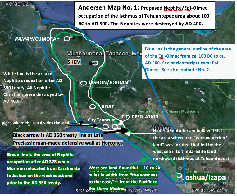
In Map No. 1 that follows, the blue line represents the area where evidence of the “Epi-Olmec,” or “Isthmian script,” has been found.[2] The area within the green line represents the area where it is proposed that the Book of Mormon locates the Nephites about AD 349, after Mormon had chased the Lamanites from Shem, located within the isthmus, back to Joshua, located on the west sea coast (Mormon 2:6), probably near Izapa. The area within the white line represents the area occupied by the Nephites after the AD 350 treaty wherein the Nephites gave up all of the land southward starting at the treaty line located at Horcones, in southern Mexico. This was the same defensive line located between the land Desolation and the land Bountiful described in Alma 22:32, Helaman 4:5–7, and 3 Nephi 3:23.[3]
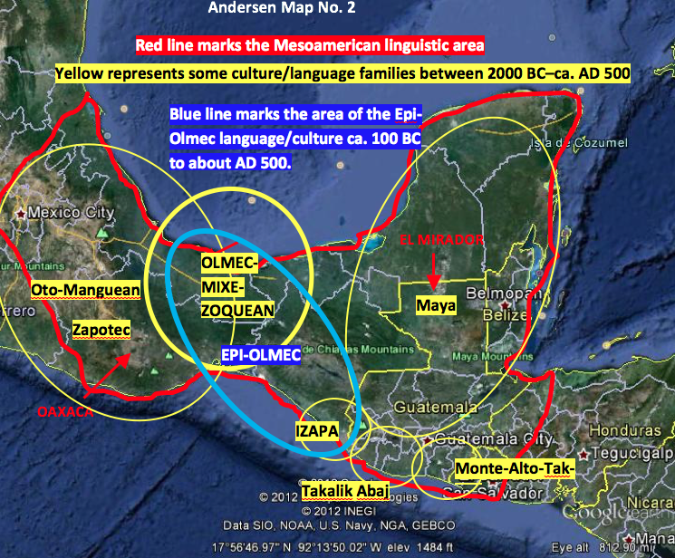
The body of knowledge about the Epi-Olmec has been growing steadily for the past twenty years, and the area of study that is responsible for this new information comes mostly from the study of ancient language scripts. It is helpful, as well as very interesting, to show, albeit with a very broad brush, some of the Mesoamerican languages/cultures from about 2000 BC to the time of the Epi-Olmec. Map No. 2 that follows shows the Mesoamerican linguistic area (in red) where the languages seem to have had a common beginning sometime prior to 2000 BC. The yellow circles and ovals represent some of the major language families and/or cultures between ca. 2000 BC and about AD 500 within the Mesoamerican language system. The blue oval represents the approximate area where the Epi-Olmec script—or other evidence—has been found.[4]
The following quotations from several of the most recent studies about Mesoamerican languages/cultures provide most of the information that was used to create the above maps. All quotations are italicized. All bolding reflects my emphasis, and my comments within or following the quotations are shown in brackets.
-
The Oto-Manguean language family is the most diverse and most geographically widespread language family represented in Mesoamerica. The internal diversity is comparable with that of Indo-European, and the Proto-Oto-Manguean language is estimated to have been spoken some time before 2000 BC. This means that at least for the past four thousand years, Oto-Manguean languages have coexisted with the other languages of Mesoamerica and have developed many traits in common with them, to such an extent that they are seen as part of a “sprachbund” called the Mesoamerican Linguistic Area.[5] [This is the area within the red line on Map No. 2.]
-
Extending from the deserts of northern Mexico to the tropical forests of northwestern Costa Rica, Mesoamerica is a geographically and ethnically diverse area that included thousands of cultures united by similarities in religion, art, language, and sociopolitical organization. Some of the familiar Mesoamerican cultures include the Aztec, the Maya, and the Olmec, with lesser publicized groups such as Zapotec, Teotihuacano, Mixtecs and Tarascan thrown in the mix.[6] [The oldest ones include the Monte Alto, Tak’alik Abaj, and Izapan cultures on the Pacific coast that began about 1800 BC.]
-
Among one of the common cultural traits found in many Mesoamerican groups is writing. In fact, Mesoamerica is the only place in the Americas where indigenous writing systems were invented and used before European colonization.[7] While the types of writing systems in Mesoamerica range from minimalist “picture-writing” to complex logophonetic systems capable [of] recording speech and literature, they all share some core features that make them visually and functionally distinct from other writing systems of the world.[8]
-
The undeciphered Zapotec script is one of the earliest forms of Mesoamerican writing.[9]
-
In addition, there was a highly elaborate and conventionalized system of symbols that appeared in the Pre-Classic throughout much of Mesoamerica. This means that symbols carved in, say, Oaxaca, could be interpreted by a knowledgeable person (maybe a chief or a shaman) in the Gulf Coast or in Morelos. While archaeologists once agreed this uniformity of symbols and icons as a product of Olmec influence (cultural, political, military, or any combination of these), now there is more of an opinion that the Olmecs were only one of the many advanced people during the Pre-Classic and thus many different cultures might have led to the development of this system of symbols.[10]
These “advanced people during the Pre-Classic” included the Pre-Zapotec in Oaxaca beginning about 1800 BC; the Olmec, suddenly beginning about 1500 BC and suddenly ending about 250 BC; the Maya beginning about 1500 BC or earlier and diminishing substantially about AD 150; and the Izapa, Tak’alik Abaj, and Monte Alto cultures beginning about 1800 BC or earlier. Could the eleven families arriving with Jared and his brother have contributed to the development of these “many advanced people” during the Early Preclassic? I believe the answer is yes. Could the sudden rise of the Olmec monumentality about 1500 BC in San Lorenzo have been the result of the Hyksos (Phoenicians) merging with the native people (Jaredites) in the Isthmus of Tehuantepec?[11] Again, I believe the answer is yes.
-
Until a few years ago, the Pre Classic, was thought to be a formative period, with small villages of farmers, that lived in huts, and few permanent buildings, but this concept has been proved to be a big mistake, due to recent findings all over Guatemala, such as a 25 mt. high Pyramid and a quatrefoil altar in La Blanca, San Marcos, some 3 mt. in diameter from 1000 BC; Ceremonial sites at Miraflores, and El Naranjo from 800 BC, near Kaminaljuyú, in Guatemala City, El Portón in Baja Verapaz, The Mural paintings in San Bartolo, Petén, the Stucco Masks and monuments in Cival and of course The Mirador Basin’s major cities of Nakbé, Xulnal, Tintal, Wakná and El Mirador, the Cradle of the Maya Civilization, where, the cities were not only numerous, but very sophisticated, and developed, with architectonic structures from 1400 BC, indeed the two biggest cities of the Maya Civilization (Mirador and Tintal) are there, with the same religious [beliefs], astronomical, mathematics and writing knowledge [of] those in the Classic period.[12]
-
The Mayan Culture developed between 3000 and 2000 BC. Pollen samples [have] shown the establishments of agriculture in Guatemala by 4000 BC, and around 2500 BC initiated the building of small cities with some permanent architecture all over the country (Pre-Classic). According to Houston the Cho’lan language, the precursor to the Maya, originated in the Guatemalan Highlands, ca 3000 BC. In the tropical lowlands of El Mirador Basin, in the Petén Lowlands, Northern Guatemala, that lead to huge cities like Mirador, Nakbé, San Bartolo, Tintal and others, although there were some early cities in the Guatemala Highlands (Naranjo, Kaminal Juyú, Nebaj, Guaytán, El Portón), and in the Pacific Low Lands (Tak’alik Abaj, Chocolá), that does not reach the size of those in Petén where they build at least 27 big cities and countless smaller ones at its peak around 250 BC, then, suffered a first collapse around 150 AD, and resurging on 250 AD (Early Classic) with large cities such as Tikal, Naranjo, Yaxhá, Cancuén, Machaquilá, Ceibal, Piedras Negras, Quiriguá, Uaxactún, and many more until their final collapse around 900 AD (Terminal-Classic).[13]
-
The origin of the Maya script has been [the] focus of attention by many scholars, and they think that all the Mayan languages as well as the Olmec had the same roots. . . . The Stela 10, in Kaminal Juyú (late Verbena phase, 400–200 BC, late Preclassic), has the earliest glyphs in Cho´lan Maya, the language used in the Classic Lowlands sites, suggesting that the origin of this language was in the Highlands, and that the relationships between the Petén and the Highlands, was closer than previously thought.[14]
-
The renowned archaeologist Dr. Richard Hansen is sure that the Maya at Mirador Basin developed the first true political state in America, (Tha Kan Kingdom), around 1500 BC, (although Maize (corn) pollen samples have been documented in lakes in the area dated in 2400 BC), not as thought before that the Olmec was the mother culture in Mesoamerica, he thinks, due to recent finding at Mirador Basin, Northern Petén, Guatemala, that the Olmec and Mayas developed its [their] cultures, separately, and merged in some places like Tak’alik Abaj on the Pacific Low Lands; there is no evidence yet to link the Pre Classic Maya from Petén and those from the Pacific coast, but undoubtedly, they had cultural and economical links. North Central Petén has particularly high densities of Late Preclassic sites,[15] including Naachtún, Xulnal, El Mirador, Porvenir, La Florida, Pacaya, La Muralla, Nakbé, Tintal, Wakná (formerly Güiro), Uaxactún,, Cival, San Bartolo, Holmul, Polol and Tikal. Of these, El Mirador, Tikal, Nakbé, Tintal, Xulnal and Wakná are the largest in the Maya world, Such size was manifested not only in the extent of the site, but also in the volume or monumentality, especially in the construction of immense platforms to support large temples.[16]
-
The city of El Mirador was the largest city in ancient America, and also, has the largest pyramid in the world, with a mass of 2,800,000 Mt2, some 200,000 more that the Giza pyramid in Egypt, and was by far the most populated city in the Pre Columbian America, in fact, Mirador was the first politically organized state in America, named the Kan Kingdom in ancient texts. The first aerial surveys of this area in the 1930s by North American archeologists do not give any results, because they interpreted the huge pyramids as volcanoes. There are 26 cities, some bigger than Tikal, the jewel of the Classic period, all connected by huge sacbeob (plural for highways), or sacbé (singular), meaning “white road,” up to 40 Km. long (Tintal-El Mirador, the largest in Mesoamerica) and up to 44 m. wide and 2 to 6 m. above the ground, paved with stucco, that are clearly distinguishable from the air in the most extensive virgin tropical rain forest left in Mesoamerica, thus, these were kingdoms equal in power and culture to those in Egypt, Mesopotamia, China, etc.[17]
-
In Monte Alto near La Democracia, Escuintla some giant stone heads and Potbellies or “Fat Boys” (Barrigones) have been found, dated at 2000 BC (Ian Graham 1979). The so-named Monte Alto Culture, that is classified as Pre-Olmec, (why not Pre-Maya?), letting the door open to the opinion of some experts that the Olmec Culture was born in that area of the Pacific Lowlands, although the size is the only similarity with the posterior dated Olmec heads, it is more accurate to say that the Monte Alto Culture was the first complex culture of Mesoamerica and the predecessors of all the other cultures. In Guatemala, there are some sites with unmistaken Olmec style, such as Chocolá in Suchitepéquez, La Corona, in Cotzumalguapa, and Tak’alik’ Ab’aj, in Retalhuleu, that is the only ancient city in Mesoamerica with Olmec and Mayan features.[18]
-
Remains of other early cultures interacting with the Olmec have been found at Takalik Abaj, Izapa, and Teopantecuanitlan, and as far south as in Honduras. Research in the Pacific Lowlands of Chiapas and Guatemala suggest that Izapa and the Monte Alto Culture may have preceded the Olmec. Radiocarbon samples associated with various sculptures found at the Late Preclassic site of Izapa suggest a date of between 1800 and 1500 BC.[19]
-
It is widely recognized that the Mixtecos and Zapotecos are actually kindred peoples, looking back to a common origin several thousand years ago. . . . The Zapotecs appeared to have shared some cultural affinities with the ancient Olmec and the Mayan Indians.[20]
As I have indicated in other articles I have written, the above information gives rise to the proposition that some of the eleven other couples arriving with Jared and his brother probably began separating themselves from the unrighteous and onerous Jaredite leadership and found other areas to raise their families. Such migrations would have occurred perhaps about 2000 BC, give or take a hundred years or so. Some of these families and their descendants probably assisted in the formation of the Pacific coastal cultures, the heartland Olmec, and perhaps the Maya, among others. This possibility would have been accomplished principally by the mixing of the migrants with existing pockets of hunter/gatherers in the various areas, which would account for many of the differences, as well as similarities, in the languages and cultural traits in the Mesoamerican linguistic area shown on the maps above.
The Epi-Olmec
After the demise of the Olmec about 250 BC, a new language and culture seemed to emerge in the isthmus area, including from about Veracruz on the north to about Tapachula (Izapa) on the south, as shown on the maps above.
- Scholars have not determined the cause of the eventual extinction of the Olmec culture. Between 400 and 350 BCE, the population in the eastern half of the Olmec heartland dropped precipitously, and the area was sparsely inhabited until the 19th century. According to archaeologists, this depopulation was probably the result of “very serious environmental changes that rendered the region unsuited for large groups of farmers,” in particular changes to the riverine environment that the Olmec depended upon for agriculture, hunting and gathering, and transportation. These changes may have been triggered by tectonic upheavals or subsidence, or the silting up of rivers due to agricultural practices.
One theory for the considerable population drop during the Terminal Formative period [involves] relocation of settlements due to volcanism, instead of extinction. Volcanic eruptions during the Early, Late and Terminal Formative periods would have blanketed the lands and forced the Olmec to move their settlements.
Whatever the cause, within a few hundred years of the abandonment of the last Olmec cities, successor cultures had become firmly established. The Tres Zapotes site, on the western edge of the Olmec heartland, continued to be occupied well past 400 BCE, but without the hallmarks of the Olmec culture. This post-Olmec culture, often labeled Epi-Olmec, has features similar to those found at Izapa,[21] some 330 miles (550 km) to the southeast.[22]
A distinct writing form developed and was used in the Isthmus of Tehuantepec from about 100 BC to about AD 500,[23] as shown in blue on Map No. 2.
- In the Gulf Coast and highland Chiapas of Mexico, where the Olmecs had lived, another script of the Southeastern group also emerged during the late Preclassic. Called Epi-Olmec (meaning “after Olmec”) on geographic and iconographic grounds, this writing system has been known for a long time but only has been studied within the last twenty years or so. The best example is the La Mojarra Stone 1.[24]
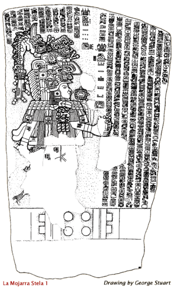
- One of the most amazing things about Mesoamerican archaeology is that new discoveries are constantly being made. Among one of the most important was the discovery of an inscribed slab found under the waters of the Acula River near the village of La Mojarra in 1986 in the Mexican state of Veracruz. Dubbed Stela 1 of La Mojarra, this monument was inscribed with 465 glyphs arranged in 21 columns, and the image of a ruler. The writing on it is nothing like any other writing system in Mesoamerica, such as Maya, Zapotec, Mixtec, or Aztec, although like the Maya it also used the Long Count.
However, Stela 1 of La Mojarra is not the only example of its writing system. Most of the monuments that bear glyphs in the same (or similar) writing system are also found near the Isthmus of Tehuantepec. . . .
Scholars have given this script many names. Epi-Olmec since it is more common in scientific literature. Some have called this script the “La Mojarra script” after the location where the Stela was found. Another name, also based on a geographical name, is the “Isthmian Script,” named after the Isthmus of Tehuantepec. You would find all three names used in publications, and websites. Yet another name is the “Tuxtla Script,” named after the Tuxtla Statuette as well as the Tuxtla Mountains near which many of the texts have been found. . . . [This is the proposed hill Ramah/Cumorah area shown in Map No. 1.]
Justeson and Kaufman proposed that the language this script recorded was pre-proto-Zoquean, which belongs to a small language family called Mixe-Zoquean. This family is still spoken today around the Isthmus of Tehuantepec.
Why Mixe-Zoquean? Why not Mayan, or any other family for that matter? Well, it has been theorized that speakers of Mixe-Zoquean languages have stayed near the Isthmus of Tehuantepec since the Pre-Classic, and many modern Mixe-Zoquean languages are still spoken in this area. . . . It is likely that the Olmecs spoke a Mixe-Zoquean language, because the environmental requirements of these plants match that of Gulf Coast Mexico. Kaufman argued that as the Olmecs transmitted their rituals, words related to these rituals also diffused. And it is also likely the people who subsequently inhabited the same geographical area as the Olmecs were descendants of the Olmecs and spoke a Mixe-Zoquean tongue. And therefore their writing system would therefore record a Mixe-Zoquean language.
Well, this isn’t truly an impeccable model. There is still not enough information to argue that there wasn’t an influx of people into the Isthmus and thus replacing earlier inhabitants. . . . There is still much to be done to either prove or disprove the Justeson and Kaufman decipherment. However, in the meantime, I will assume that their work is valid and present an overview based on their work.[25]
In other words, evidence might exist that there was “an influx of people into the isthmus”. There is evidence that some of this influx of people into the isthmus, replacing the earlier inhabitants, actually came from the Pacific coastal area, including Izapa. This evidence is consistent with the area where the majority of the Nephites had either lived or traveled through as they migrated from Zarahemla westward to Joshua on the west sea (Izapa area) and then northward up the coast across the “line” between Bountiful and Desolation. This is the “line” that Dr. Hauck and I believe is located within the narrow neck of land that led by the west sea into the Jaredite land northward (the Isthmus of Tehuantepec), as shown in the map above.
From an overview perspective of the Epi-Olmec script, “the Epi-Olmec script turned out to be structurally similar to the Maya.[26] It is logophonetic.[27] Some archaeologists think that the Olmec also spoke a Proto-Maya language.[28]
The Jaredites occupied the Jaredite land northward from ca. 2100 BC to ca. 250 BC, mostly coterminous with the Olmec heartland whose occupation is shown to have quite suddenly come into existence about 1500 BC. It appears that the Jaredite land northward included all of the Isthmus of Tehuantepec from the “line” between Desolation and Bountiful located at Horcones, which is near Tonala, Mexico, northward to about the Papaloapan Basin.[29] (See also endnote No. 30.) The people living in this Jaredite/Olmec heartland were virtually destroyed about 250 BC.[30]
By the year 72 BC, the Nephite migrations from the land southward into the then sparsely populated Jaredite land northward had begun. By 46 BC, the migrations were accelerating:
And it came to pass that they did multiply and spread, and did go forth from the land southward to the land northward, and did spread insomuch that they began to cover the face of the whole earth [of the Jaredite land northward], from the sea south to the sea north. (Helaman 3:8)
The supposition that the Nephites eventually inhabited—but not exclusively—most of the Jaredite land northward (the “whole earth”) seems to be confirmed by the additional following facts:
1. Mormon was born there (Mormon 1:6).
2. Ammaron, keeper of the records, also lived in the land northward (Mormon 1:2).
3. Nephi and Lehi both performed unsuccessful missionary work there for six years (Helaman 6:6, 7:1).
4. The hill Shim was located there, and all the Nephite records were deposited there (Mormon 1:3).
5. The Nephite city Jashon/Jordan was located near hill Shim (Mormon 2:17).
6. The Nephite city Shem was located north from Jashon/Jordan (Mormon 2:17, 20).
7. Many Nephite cities were located within the isthmus from the “line,” beginning with the city of Desolation and thence northward to Ramah/Cumorah (Mormon 4:22, 5:4–5). These cities included Teancum, Boaz, Jashon/Jordan, Shem, and Cumorah, among many others.
8. There were over 230,000 of the rest of the Nephite people killed at Cumorah about AD 385 (Mormon 6:11–15).
9. Cumorah had to have been located just southward from Ripliancum (Papaloapan Basin) because Ramah was located just southward of Ripliancum (Ether 15:8).
10. The Nephites occupied the former land of the Jaredites from their south sea (the Pacific or Gulf of Tehuantepec) to their north sea (the Gulf of Mexico) (Helaman 3:8).
11. The Nephites occupied the Jaredite land northward for more than 450 years beginning ca. 72 BC to about AD 400. (There is no indication that this was an exclusive occupation.)
12. In AD 329, Mormon fled Zarahemla and was able to stop the Lamanite advance at Joshua, near the west sea, where he accumulated all his people in one body (Mormon 2:7). With his army of 42,000, he repelled the Lamanite army of 44,000. Afterwards, there followed many wars and battles from Joshua to Desolation, then to Jashon/Jordan, and then to Cumorah wherein innumerable thousands of Nephites were killed. Yet in four years at Cumorah, Mormon was able to accumulate an army of at least 230,000 people. Where did they come from if not from within the northern part of the isthmus, the same area where the principal part of the Epi-Olmec had lived?
13. It is not just a coincidence that the Nephite occupation of the entire isthmus occurred at the same time and place as the archaeologically proven reoccupation of most of the isthmus by the “remnant Olmec,” among others. This reoccupation of the entire Isthmus of Tehuantepec from about 100 BC to AD 500, of course, included the 150 years of peace following Christ’s resurrection and appearance to the Nephites and others. This helps to account for the huge numbers of people who were occupying the area about AD 385.
14. Therefore, it seems probable that the Epi-Olmec or Isthmian Culture included the Nephite culture. When the Lamanites/Gadianton robbers destroyed most of the Nephites in that last major battle at Cumorah, they were not satisfied but continued hunting for every person who would not deny the Christ and killed them all. This included finally killing Mormon in battle. By AD 401, there was not a Christ-believing person alive except Moroni (Mormon 8:6–9).Yet the fierce battles continued on the face of the land between the Lamanites/Gadianton robbers and who else?
Question: Why was this invading force from the land southward still fighting when they had won their objective and destroyed all the Christians?
Answer: They were fighting the non-Christian, non-Nephite Epi-Olmec (considered Lamanite by the Book of Mormon writers) in the area as they tried to appropriate the isthmus for themselves. Something must have happened in the isthmus after AD 400 because by AD 500, the Epi-Olmec culture apparently ceased to exist as a distinct language/culture.
Certainly not all of the Epi-Olmec/Nephites believed in Christ. Anyone who would not deny Christ was killed. We can reasonably assume that, after that final battle, the correct belief in Jesus Christ was destroyed. Thereafter, the “Lamanites” (anyone not believing in Christ) attempted to destroy all references and signs of Christ and of the Nephites. The term “Lamanite,” from AD 400 forward, including in the United States, encompassed all cultures that existed in the Americas because, by definition, a Lamanite was anyone not adhering to Christian beliefs and principles as practiced by the Nephites. Therefore, Joseph Smith appropriately referred to the American Indian as “Lamanite.”
This hatred for, and destruction of, anything Christian is certainly one reason why it is so difficult to archaeologically find any definitive vestige of the Nephite culture, language, writing, or artifacts in Mesoamerica. There is one possible exception, however, and that is the monumental architecture and the arts at Izapa, Mexico, including, but not limited to, the famous Stela 5, known by many as the Tree of Life Stone, the details of which have been wonderfully preserved by Garth Norman. This does seem to relate to Lehi’s dream mentioned in chapter eight of first Nephi, as beautifully explained by many Latter-day Saint authors, including Joseph and Blake Allen in Exploring the Lands of the Book of Mormon.[31] There are many wonderful books and articles located at www.BMAF.org that further corroborate that the events of the Book of Mormon literally and historically occurred in Mesoamerica.
The many convergences of Book of Mormon locations and statements with geographical, archaeological, and anthropological evidence, as shown in this article and others, confirm the “divine authenticity” of the Book of Mormon and its location in Mesoamerica.
From my perspective and based on my analyses, Joseph Smith also believed that the events of the Book of Mormon occurred in Central America. In 1842, the Prophet Joseph Smith gave his latest non-revelatory statements of his personal beliefs regarding the geography of the Book of Mormon. They are found in the Church’s newspaper in 1842, the Times and Seasons, for which Joseph was editor and manager and for which he had personally assumed complete responsibility. These statements confirm, regardless of any prior inconsistent statements that he may have made, that he believed, in September 1842 (and never denied prior to his death) that Central America was the location of most of the New World events recorded in the Book of Mormon.
I believe that Joseph authored, coauthored, commissioned someone else to write, or, at the very least, fully approved and never disapproved the following statement from the September 15, 1842, issue of the Times and Seasons:
[The] great developments of antiquities are made bare to the eyes of all the people by reading the history of the Nephites in the Book of Mormon. They lived about the narrow neck of land, which now embraces Central America, with all the cities that can be found. . . . Who could have dreamed that twelve years [since the publication of the Book of Mormon] would have developed such incontrovertible testimony to the Book of Mormon? Surely the Lord worketh and none can hinder.[32]
Other similar statements, either written by or approved by Joseph Smith, are found in the Times and Seasons while Joseph was editor in 1842.[33] It is also of great importance that the only other people who could have been the author of those articles were Wilford Woodruff and John Taylor, both of whom became Presidents of the Church and both of whom never denied or corrected those articles. Recently, Jonathan Neville—in defense of the Heartland Theory for New World Book of Mormon geography—has claimed the possibility that Benjamin Winchester could have initially authored or promulgated these articles.[34] However, I firmly disagree with his conclusions and agree with Mathew Roper’s analyses.[35]
Some of the conclusions and speculations in this article, although interesting and probative, may, nonetheless, be susceptible to debate, which is certainly encouraged because all serious students of the archaeology and geography of the Book of Mormon are searching for the actual locations where the New World events of this marvelous book took place. To accomplish this objective, we must maintain an open, honest, and intelligent dialogue based on the Book of Mormon. Nevertheless, we must also take into account the known archaeological, anthropological, and geographical evidence in the area. However, there is one final conclusion that is absolute:
The “veracity and divine authenticity of the Book of Mormon” absolutely prove the reality and divinity of Jesus Christ, to which I attest.
Notes
[1]. According to Joseph Allen and Blake Allen, “[The discoveries by the Limhi expedition] suggest that the time period from the destruction of the Jaredites to Limhi was not almost five hundred years (600 BC to 121 BC) but was a more believable scenario such as Ixtlilxochitl’s destruction date of 236 BC [for the Olmecs]—or a little over a hundred years for the decaying of the bones and swords. Both archaeological and historical data support 300 BC, plus or minus fifty years, for the destruction of the first civilization” (Joseph Lovell Allen and Blake Joseph Allen, Exploring the Lands of the Book of Mormon, 2nd ed. rev. [American Fork, UT: Covenant Communications, 2011], 130.
[2]. The area in blue on the map was copied in 2012 from a map in the Epi-Olmec section of www.ancientscripts.com. The ancientscripts.com map and some of the information have changed somewhat from 2012 when this article was first published. The ancientscripts.com map included Tapachula as the southern area of the Epi-Olmec language culture area. Some scholars apparently now believe the Epi-Olmec were concentrated in the Tuxtla area of the Isthmus of Tehuantepec. However, this script has been found in the Chiapas area, and there are other indications that this culture extended into Izapa, Chiapas:
-
Chiapa de Corzo is also notable for a pottery sherd containing what is likely Epi-Olmec script. Dated to as early as 300 BCE, this sherd would be the oldest instance of that writing system yet discovered. (“Chiapa de Corzo (Mesoamerican site),” https://en.wikipedia.org/wiki/Chiapa_de_Corzo_(Mesoamerican_site), (accessed June 27, 2015).
-
In the pre-Hispanic period, the Zoque lived throughout Chiapas, and Isthmus of Tehuantepec and parts of the state of Tabasco. They are predecessors of the Olmec. They had a good social and commercial relationship with the later Mexica, which contributed to the economic prosperity of their culture in Chiapas. (“Zoque People,” https://en.wikipedia.org/wiki/Zoque_people [accessed June 27, 2015]) (The language family in blue on the map shows the boundaries of this people, called the Mixe-Zoquean.)
-
The Olmec flourished during Mesoamerica’s formative period, dating roughly from as early as 1500 BCE to about 400 BCE. Pre-Olmec cultures [Zoque, Izapan, had flourished in the area since about 2500 BCE, but by 1600–1500 BCE, Early Olmec culture had emerged, centered on the San Lorenzo Tenochtitlán site near the coast in southeast Veracruz. (“Olmec,” https://en.wikipedia.org/wiki/Olmec [accessed June 27, 2015])
-
Summarized here is the current state of the phonetic decipherment, the methods used for the decipherment, and results concerning the epi-Olmec language and script. The language identified in the inscriptions is pre–proto-Zoquean, the ancestor of four languages now spoken in the states of Veracruz, Tabasco, Chiapas, and Oaxaca. The decipherment contributes to knowledge of early Mixe-Zoquean language history. The script is more closely related to Mayan hieroglyphic writing than to other early Mesoamerican scripts, and this relation is closer than previously recognized. (From abstract of John S. Justeson and Terrence Kaufman, “A Decipherment of Epi-Olmec Hieroglyphic Writing,” Science 259, no. 5102, 1703–1711, http://www.sciencepubs.org/content/259/5102/1703.full.pdf [accessed June 27, 2015]).
-
This post–Olmec culture, often labeled Epi-Olmec, has features similar to those found at Izapa, some 330 miles (550 km) to the southeast.
[3]. There was a narrow neck and a narrow pass that led by the west sea into the Jaredite land northward. These two locations must be the same place because: each leads into the Jaredite land northward; each is located by the west sea; and each is located within the land Desolation. The land Desolation is part of the Jaredite land northward and begins at the line between Desolation and Bountiful. And the “Line” and Desolation and Bountiful all start at the same point on the west sea.
And it came to pass that they did not head them until they had come to [not in] the borders of the land Desolation; and there they did head them, by [not in] the narrow pass which led by the [west sea] into the land northward, yea, by the sea, on the west and on the east. (Alma 50:34, about 67 BC)
And it came to pass that Hagoth, he being an exceedingly curious man, therefore he went forth and built him an exceedingly large ship, on [within] the borders of the land Bountiful, by [near but not in] the land Desolation, and launched it forth into the west sea, by [near but not in] the narrow neck which led [by the west sea] into the land northward. (Alma 63:5, about 55 BC)
There was also a narrow pass and a narrow passage that led by the west sea into the land southward. These two locations must be the same because each started at the beginning of the land southward and the beginning of the land southward was at the same line between bountiful and Desolation. The "line", Desolation, and Bountiful all began at the precise same location on the west sea and at exactly the same location as where the narrow neck and narrow pass began that led by the west sea into the Jaredite land northward.
And in the three hundred and fiftieth year we made a treaty with the Lamanites and the robbers of Gadianton, in which we did get the lands of our inheritance divided. And the Lamanites did give unto us the land northward [of the “line”], yea, even to [not in] the narrow passage which led into the land southward. And we did give unto the Lamanites all the land southward [of the line including the narrow passage]. (Mormon 2:28–29, about AD 350)
Notice that the narrow passage (by the west sea) leading into the land southward was a part of the land southward. The Lamanites did not give this narrow passage to the Nephites because this passage began at the treaty “line” and went southward (see Mormon 3:5). The Nephites received everything north of the line (beginning at Desolation), which included the narrow neck of land leading into the land northward.
And it came to pass that I did cause my people that they should gather themselves together at the land Desolation, to a city which was in [within] the borders [of the land Desolation], by [near but not in] the narrow pass which led into the land southward [because this pass was given to the Lamanites and Robbers by treaty]. (Mormon 3:5, about AD 360)
There was only one location called by the Nephites “Desolation,” and it always bordered the west sea. The narrow pass that led into the land southward started at the line between Desolation and Bountiful, and that line started on the west sea. Therefore, the city Desolation was located near the west sea and near but north of the “line” that divided the narrow neck leading into the country of the land northward from the narrow pass/passage that led into the (country of the) land southward.
[4]. See “Mesoamerican Writing Systems,” http://www.ancientscripts.com.
[5]. “Oto-Manguean Languages,” https://en.wikipedia.org/wiki/Oto-Manguean_languages (accessed June 29, 2015).
[6]. “Mesoamerican Writing Systems,” http://www.ancientscripts.com/ma_ws.html (accessed June 21, 2015).
[7]. One possible exception to this statement is the ancient Pre-Inca “quipu” (script?) which began about 2600 BC (AncientScripts.com: Timeline).
[8]. “Mesoamerican Writing Systems,” http://www.ancientscripts.com/ma_ws.html (accessed June 21, 2015); emphasis added.
[9]. “Oto-Manguean Languages,” https://en.wikipedia.org/wiki/Oto-Manguean_languages (accessed June 29, 2015).
[10]. “Mesoamerican Writing Systems,” http://www.ancientscripts.com/ma_ws.html (accessed June 21, 2015); emphasis added.
[11]. See S. C. Compton, Exodus Lost: An Inquiry into the Genesis of Civilization (n.p.: S. C. Compton, 2010).
[12]. “Ancient Guatemala, http://www.authenticmaya.com/ (accessed June 29, 2015).
[13]. “Maya Culture,” http://www.authenticmaya.com/maya_culture.htm (accessed June 29, 2015).
[14]. “Maya Writing,” http://www.authenticmaya.com/maya_writing.htm (accessed June 29, 2015).
[15]. Notice that many of these sites are historically called “Late Preclassic,” such as El Mirador as cited above. However, in reality, El Mirador had its beginning before 1500 BC. Its apogee was about 300 BC, and its initial demise occurred about AD 150. Analysts should not rely on current terminology but should look to the actual radiocarbon dating of the various sites and also recognize that many ruins are built upon earlier ruins.
[16]. “Ancient Guatemala,” http://www.authenticmaya.com/ancient_guatemala.htm (accessed June 29, 2015).
[17]. “Ancient Guatemala,” http://www.authenticmaya.com/ancient_guatemala.htm (accessed July 7, 2015); some usage errors in original corrected.
[18]. “Ancient Guatemala,” http://www.authenticmaya.com/ancient_guatemala.htm (accessed July 7, 2015); some usage errors in original have been corrected.
[19]. “Mesomerica,” https://en.wikipedia.org/wiki/Mesoamerica (accessed July 7, 2015).
[20]. John P. Schmal, “The Mixtecs and the Zapotecs: Two Enduring Cultures of Oaxaca,” http://www.houstonculture.org/mexico/oaxaca_cultures.html (accessed July 7, 2015).
[21]. The Nephite/Lamanite people (about 580 BC) settled in the area where the highland Mayan cultures were beginning to develop (the Salama Valley area). From before about 90 BC, the Nephites had control of all the lands northward from the narrow strip of mountainous wilderness and along the west sea (the Pacific coast). This is the area of west-sea land Bountiful to the “line” between Bountiful and Desolation (Alma 22:30–34). Therefore, when the Nephites began migrating into the Jaredite land northward (the Isthmus of Tehuantepec) about the year 72 BC, they brought with them their culture, which would have reflected the culture of the area around Izapa. Undoubtedly, they would have mixed with some of the remnant Olmec in the area. It appears that this was part of the foundation of what some archaeologists have described as the “Epi-Olmec or Isthmian culture.”
[22]. “Olmec,” https://en.wikipedia.org/wiki/Olmec (accessed September 29, 2015).
[23]. See “Epi-Olmec,” http://www.ancientscripts.com/epiolmec.html (accessed September 28, 2015).
[24]. “Mesoamerican Writing Systems,” http://www.ancientscripts.com/ma_ws.html (accessed September 28, 2015).
[25]. “Epi-Olmec,” http://www.ancientscripts.com/epiolmec.html (accessed September 29, 2015).
[26]. On July 12, 2011, Rolando Amado, president of the Archeological Research Institute of Mesoamerica, made an additional unedited comment that I thought worth adding to this article: “Joe, If you carefully look at the glyphs of all those ‘different sculptures’ (especially at drawings of them), you will notice that they are, indeed, very similar to a Maya-style that can also be classified as very early, early, early Preclassic, medium Preclassic, etc., and this fact points also to the conclusion that maybe a common point of origin for written language existed in the Mesoamerican area.”
[27]. “Epi-Olmec,” http://www.ancientscripts.com/epiolmec.html (accessed September 29, 2015).
[28]. “Maya Culture,” http://www.authenticmaya.com/maya_culture.htm (accessed September 29, 2015).
[29]. I believe that the Jaredite land northward included the Oaxaca valley area and that the principal Jaredite land northward extended to about the Papaloapan basin.
[30]. See my article, “Geography of the Jaredites,” http://www.bmaf.org/articles/geography_jaredites–andersen.
[31]. See Allen and Allen, Exploring the Lands of the Book of Mormon, 333–51.
[32]. “Extract from Stephen’s ‘Incidents of Travel in Central America,’” Times and Seasons 3, no. 22, September 15, 1842, 915; emphasis added; capitalization modernized.
[33]. Here are some of the other statements regarding the geography of the Book of Mormon found in the Times and Seasons while Joseph Smith was editor in 1842. Again, Joseph either authored these statements, coauthored them, commissioned them to be written, or, at the very least, approved them:
If men, in their researches into the history of this country, in noticing the mounds, fortifications, statues, architecture, implements of war, of husbandry, and ornaments of silver, brass, &c.—were to examine the Book of Mormon, their conjectures would be removed, and their opinions altered; uncertainty and doubt would be changed into certainty and facts; and they would find that those things that they are anxiously prying into were matters of history, unfolded in [the Book of Mormon]. They would find their conjectures were more than realized—that a great and a mighty people had inhabited this continent—that the arts sciences and religion, had prevailed to a very great extent, and that there was as great and mighty cities on this continent as on the continent of Asia. Babylon, Ninevah, nor any of the ruins of the Levant could boast of more perfect sculpture, better architectural designs, and more imperishable ruins, than what are found on this continent. Stephens and Catherwood’s researches in Central America abundantly testify of this thing. The stupendous ruins, the elegant sculpture, and the magnificence of the ruins of Guatemala, and other cities, corroborate this statement, and show that a great and mighty people—men of great minds, clear intellect, bright genius, and comprehensive designs inhabited this continent. Their ruins speak of their greatness; the Book of Mormon unfolds their history.-ED. (Joseph Smith, “American Antiquities,” Times and Seasons 3, no. 18, July 15, 1842, 860; emphasis added; spelling modernized.)
The foregoing extract [from John Lloyd Stephens, Incidents of Travel in Central America, Chiapas, and Yucatan] has been made to assist the Latter-Day Saints, in establishing the Book of Mormon as a revelation from God. It affords great joy to have the world assist us to so much proof, that even the most credulous cannot doubt. We are sorry that we could not afford the expense to give the necessary cuts referred to in the original. Let us turn our subject, however, to the Book of Mormon, where these wonderful ruins of Palenque are among the mighty works of the Nephites:—and the mystery is solved. (“Extract from Stephen’s ‘Incidents of Travel in Central America,’” Times and Seasons 3, no. 22, September 15, 1842, 914; emphasis added)
From an extract from “Stephens’ Incidents of Travel in Central America,” it will be seen that the proof of the Nephites and Lamanites dwelling on this continent, according to the account in the Book of Mormon, is developing itself in a more satisfactory way than the most sanguine believer in that revelation, could have anticipated. It certainly affords us a gratification that the world of mankind does not enjoy, to give publicity to such important developments of the remains and ruins of those might people. (“Facts Are Stubborn Things,” Times and Seasons 3, no. 22, September 15, 1842, 921–22; emphasis added)Since our “Extract” was published from Mr. Stephens’ “Incidents of Travel,” &c., we have found another important fact relating to the truth of the Book of Mormon. Central America, or Guatemala, is situated north of the Isthmus of Darien and once embraced several hundred miles of territory from north to south. The city of Zarahemla, burnt at the crucifixion of the Savior, and rebuilt afterwards, stood upon this land. . . . It is certainly a good thing for the excellency and veracity, of the divine authenticity of the Book of Mormon, that the ruins of Zarahemla have been found. . . . We are not going to declare positively that the ruins of Quirigua are those of Zarahemla, but when the land and the stones, and the books tell the story so plain, we are of opinion, that it would require more proof than the Jews could bring to prove the disciples stole the body of Jesus from the tomb, to prove that the ruins of the city in question, are not one of those referred to in the Book of Mormon. (“Zarahemla,” Times and Seasons 3, no. 23, October 1, 1842, 927; emphasis added; spelling modernized. Note here that the demonstrative “this” in this case refers not to where Joseph was standing or where the Times and Seasons was printed but to the subject of the sentence, “Central America, or Guatemala.”)
There can be no reason for doubt here. The above statements are clear and give definiteness, direction and distance. Joseph Smith never refuted, contradicted, or modified any of these statements up to the time of his martyrdom twenty months later; nor did John Taylor or Wilford Woodruff.
[34]. See my article, “Response to Neville’s The Lost City of Zarahemla,” http://www.bmaf.org/articles/response_neville’s_lost_zarahemla–andersen.
Jonathan Neville proposes that the once-faithful, dynamic missionary and friend of Joseph Smith, Benjamin Winchester, was the author of the nine hundred editorial words contained in three articles in the September15 and October 1, 1842, issues of Times and Seasons. These nine hundred editorial words identify Central America and Guatemala as the geographic area where the Book of Mormon took place. Even though Neville admits that this conclusion is based almost exclusively on circumstantial evidence, I found that the evidence was very informative, nicely presented, and plausibly accurate. Neville’s presentation met the prima facia threshold by a preponderance of the evidence. Perhaps there is another side of the story; however, for purposes of this article, I am willing to admit to the possibility that Benjamin Winchester possibly wrote, or at least possibly initiated and promulgated, the said nine hundred editorial words.
Having said that, I point out that clearly, all three prophets and Presidents of the Church who had knowledge of and participated in the publishing of the Times and Seasons never recanted, rejected, modified, or disputed those nine hundred editorial words.
Neville’s book reaffirms the conclusion—and all scholars and authors of Book of Mormon geography should now be in agreement with the fact—that neither Joseph Smith, nor any other prophet, has ever claimed to have received definitive revelation as to where the geography of the Book of Mormon took place. Had Joseph done so, there would be no discussion today by those faithful in the Church. There would be no book by Jonathan Neville, The Lost City of Zarahemla: From Iowa to Guatemala—and Back Again. In fact, there would be no need to “decipher the geography of the Book of Mormon.” Joseph Smith did not know by revelatory means where the Book of Mormon took place, although he apparently personally believed, at the time he was martyred, that the New World events of the Book of Mormon occurred in Mesoamerica—as evidenced by the Times and Seasons articles.
[35]. See Matthew Roper, “The Treason of the Geographers: Mythical ‘Mesoamericn’ Conspiracy and the Book of Mormon,” Interpreter: A Journal of Mormon Scripture 16, (2015): 161–205, www.mormoninterpreter.com/ (accessed August 21, 2015); Matthew Roper, “John Bernhisel’s Gift to a Prophet: Incidents of Travel in Central America and the Book of Mormon,” Interpreter: A Journal of Mormon Scripture 16 (2015): 207–53, www.mormoninterpreter.com/john-bernhisels-gift-to-a-prophet-incidents-of... (accessed August 28, 2015); Matthew Roper, Paul Fields, and Larry Bassist, “Zarahemla Revisited: Neville’s Newest Novel,” Interpreter: A Journal of Mormon Scripture 17 (2016): 13–61, www.mormoninterpreter.com/zarahemla-revisted-nevilles-newest-novel/ (accessed September 25, 2015).