


Isthmus of Tehuantepec: Not the “Narrow Neck of Land”
Isthmus of Tehuantepec: Not the “Narrow Neck of Land”
In 1988, Dr. F. Richard Hauck broke with this traditional assumption and proposed that the narrow neck of land was not an isthmus:
One of the traditional assumptions of Book of Mormon scholars and casual readers alike has been to equate the “narrow neck of land” with an isthmus. Because this assumption has been widely accepted without careful examination, it has complicated and confused the numerous attempts made to identify the setting of the book.
He then proposed, instead, that the narrow neck of land was an area within the narrow Pacific coastal shelf of southeastern Mexico and, therefore, could not have been the Isthmus of Tehuantepec. He reasoned as follows:
Since two bodies of water flanking a narrow strip of land create an isthmus,1 the “narrow neck of land” as described in the Book of Mormon does not qualify as an isthmus. . . . Careful analyses of all the references in the text to this topographic feature fail to identify the presence of two seas flanking the transportation corridor. The description of a transportation corridor narrowly constricted on the west flank by the sea and on the east flank by a possible mountain barrier does, however, qualify as a land bridge.2
The purpose of this article is to show, from the Book of Mormon, that Hauck’s hypothesis is correct. For emphasis, convenience, and accessibility, all Book of Mormon scriptures will be in italics. All emphasis by bolding is the author’s.
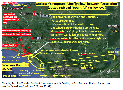
The Book of Mormon clearly describes a “line,” not a neck of land, running from the west sea easterly about fifteen miles or so to some non-sea landmark. This line divided the land Desolation, a part of the Jaredite land northward, from the land Bountiful, a part of the Nephite land southward (Alma 22:32). (See also 3 Nephi 3:23, which states “yea, to the line which was between the land Bountiful and the land Desolation.”
Mormon describes a “narrow pass” and/or a “narrow neck” that led from that “line” running by the west sea into the land northward:
The Narrow Pass ca. 67 BC: [Talking about Teancum stopping Morianton before Morianton could get into the Jaredite land northward]: And it came to pass that they did not head them until they had come to [but not in and therefore close to the “line”] the borders of the land Desolation; and there they did head them, by [not in] the narrow pass which led by the [west] sea into the land northward, yea, by the sea, on the west. (Alma 50:34) [They were stopped near the west sea just before crossing the “line”—borders—and going into Desolation.]
The Narrow Neck ca. 55 BC: Hagoth . . . built him an exceedingly large ship, on [within] the borders of the land Bountiful by [near but not in (and therefore close to the “line”)] the land Desolation, and launched it forth into the west sea, by [near but not in] the narrow neck which led into the land northward. (Alma 63:5)
Both scriptures describe a transportation corridor leading into the Jaredite land northward. Both scriptures state that this pass/neck that led into the land northward was located adjacent to the same west sea. There is only one area in the Book of Mormon called “Desolation” by the Nephites. Never in the Book of Mormon is the land Desolation mentioned or associated with any sea other than the west sea. The purpose of the “pass” and the “narrow neck” in the above referenced scriptures was merely to get to the Jaredite land northward, not to pass through it to the other side. Never in the Book of Mormon does it state that this pass/narrow neck led to Cumorah, or to the north sea, or to the place of the first landing of the Mulekites.
Alma 22:30 says only that Desolation came into—not through to the other side—“the land that had been peopled and destroyed.” It was the sea north of this Jaredite land northward where the Mulekites made their first landing, not at the land Desolation, which only bordered the west sea.
The “narrow neck” in this scripture did not divide anything. The land Desolation and the west-sea land Bountiful did not divide anything, nor did the narrow pass leading by the west sea into the land northward. As will be shown hereafter, it was the “line” located within and crossing the “small neck of land” from the west sea to the east that divided the lands northward/southward.
Mormon also describes a “narrow pass” and a “ narrow passage” that led from the same “line” into the land southward. (Readers should notice that this “pass” and/or “passage” also did not divide anything.)
The other narrow pass ca. AD 350: And it came to pass that I did cause my people that they should gather themselves together at [within] the land Desolation [therefore near the west sea], to a city which was in the borders [of land Desolation], by [but not in and therefore close to the “line”] the narrow pass which led into the land southward (Mormon 3:5). [This narrow pass had to have begun at the same line—the treaty line—and therefore it was the same location where the narrow passage described in Mormon 2:29 began. City Desolation was located close enough to cast the dead Lamanites into the west sea. This confirms that the narrow passage was also located close to the west sea.]
The narrow passage ca. AD 350: And the Lamanites did give unto us the land northward, yea, even to [not in and therefore close to the “line”] the narrow passage which led into the land southward. And we did give unto the Lamanites all the land southward (Mormon 2:29). [This was the AD 350 treaty line. If “all the land southward” was given to the Lamanites, then that narrow passage that led into the land southward must have begun at the treaty “line” and was included as part of the land southward.]
Because (1) there was a narrow pass/narrow neck that led by the west sea into the land northward and a different narrow pass/narrow passage that led into the land southward, (2) there was a “small neck of land between” the lands northward/southward (Alma 22:32), (3) Desolation was a part of the land northward and Bountiful was a part of the land southward, and (4) there was a “line”— a day and a half in length from the east to the west sea—between Desolation/Bountiful, then that “line” must have been located within the “small neck of land.”
It then stands to reason that the “line” must also have been where the “narrow passes” or “passage” or “narrow neck which led into the land northward” met (Alma 63:5)—one going northward through Desolation into the land northward and the other going southward through Bountiful into the land southward.
This being the case, then the conclusion seems inescapable that “the narrow neck of land,” referred to in Ether 10:20, must have been either (1) the same thing as the “small neck of land” referred to in Alma 22:32 or (2) the same thing as the narrow neck or pass or passage that led by the west sea into the lands northward/southward.
In either case, the narrow neck of land and/or the small neck of land could not have been the Isthmus of Tehuantepec because (1) the width of the small or narrow neck of land was only about fifteen miles or so from “east to the west sea” (2) the “line” dividing the lands northward from the lands southward must have begun on the west sea and run in an east-to-west direction, not north to south, and (3) if the “small neck of land between” them was the isthmus, then the land northward would be the Gulf of Mexico and the land southward would be the Gulf of Tehuantepec!
The definitions of “between” and “small” are helpful in understanding this scripture:3
Between: In the intermediate space, without regard to distance; as, New York is between Boston and Philadelphia; the Delaware river runs between Pennsylvania and New Jersey.
Small: Slender; thin; fine; of little diameter; hence in general, little in size or quantity; not great; as a small house; a small horse; a small farm; a small body; small particles.
An analogy that seems to help us understand how Mormon probably used these terms—and to understand the nature of the “small neck of land,”—is the human neck. It does not divide the head from the body but connects it. It is not the head or the body, but the neck is different. And it is small and is located “between” them—the head to the “northward” and the body to the “southward.” Thus, as stated in No. 3 above, “land northward” would have been the Gulf of Mexico and the land southward the Gulf of Tehuantepec? An impossibility!
If we skewed the isthmus around and made the “small neck of land” between the land on the west—the land northward? and the land on the east—the land southward? then not only would the directions be wrong but the isthmus would not be part of either and therefore the heartland of the Olmec territory would not be part of the land northward or southward. This is another reason why the isthmus cannot be the “small neck of land.”
This conclusion is confirmed by Ether 10:19–21, which states the following (remember that the start of the land southward was always at the “line” that began on the west sea):
And it came to pass that Lib also did that which was good in the sight of the Lord. And in the days of Lib the poisonous serpents were destroyed [at the “line” where the serpents had hedged up the way (Ether 9:33), so no Jaredite could get into the land southward]. Wherefore they did [cross the “line” and] go into the land southward, to hunt food for the people of the land, for the land [Bountiful; see Alma 22:31] was covered with animals of the forest. And Lib also himself became a great hunter. And they built a great city by [near but not in that part of] the narrow neck of land [that led by the west sea into the land southward], by [near but not in] the place where the sea [singular] divides the land. And they did preserve the land southward [always defined as being from the “line” separating or dividing Desolation from Bountiful] for a wilderness, to get game. And the whole face of the land northward [from the same “line” including Desolation] was covered with inhabitants. [Therefore, the entire isthmus from that “line” and northward to the waters of Ripliancum (possibly the Papaloapan Basin) was covered with inhabitants, but that part of the “narrow neck of land/small neck of land” from the “line” and southward was covered only with game at that time, ca. 900 BC.] (Ether 10:19–21)
What follows from this conclusion is that the city Desolation and the “place where the sea [only one sea] divides the land” must also have been located within the land Desolation by the west sea just northward from the “line” because there is only one area called Desolation in the Book of Mormon and it borders only the west sea.
Only one transportation passage into the lands northward/southward is described in the Book of Mormon—the west sea corridor.4 These conclusions are reinforced by the fact that the west sea is the only place where the Nephites could have cast the bodies of the dead Lamanites ca. AD 362 (Mormon 3:2).
Understanding the nature of the “line” between Desolation and Bountiful is central and controlling for Book of Mormon readers who are trying to comprehend the geography of the Book of Mormon—especially as they attempt to locate the “small neck of land.” Following are all the Book of Mormon references and associated events that geographically relate to that “line” and hence within or very near the small neck of land.
-
It began on the west sea and ran eastward a distance of "only the distance of a day and a half's journey" —about fifteen miles or so (Alma 22:31–33, Helaman 4:6–7).
-
It never bordered any other sea.
-
It was located northward from Joshua, which was also located near the west sea (Mormon 2:6).
-
It divided Desolation from Bountiful, both of which also began on the west sea (Alma 22:31–33).
-
The “line” was not the same thing as the “narrow neck of land” or “small neck of land.” or the pass, passage, or narrow neck as discussed above because the "line" led only eastward from the west sea 15 miles or so to an undisclosed identifiable geographical feature.
-
It was not the same as the two passes, the passage, or the narrow neck, all of which did not divide anything but each of which led only into the lands northward/southward:
o “the narrow pass which led by the [west] sea into the land northward” (Alma 50:34).o “the narrow pass which led into the land southward” (Mormon 3:5).o “the narrow passage which led into the land southward” (Mormon 2:29.o “the narrow neck which led into [did not divide] the land northward” (Alma 63:5).
-
It did not lead into Desolation or Bountiful because the “line” went from the west sea eastward "only the distance of a day and a half's journey" to some identifiable landmark —not a sea but probably the Sierra Madre Mountains (Helaman:4:6–7). Desolation was located, not north or east, but northward from that line. Bountiful was located, not south or west, but southward from that line. Desolation was part of the Jaredite land northward beginning at the “line” (Alma 22:32).
-
Bountiful was a part of the Nephite land southward, and it began at the same “line” (Alma 22:32).
-
It was the Jaredite entrance or gate into the land southward. “And they did preserve the land southward for a wilderness, to get game. And the whole face of the land northward [from the line] was covered with inhabitants.” Lib built his city by the entrance ['line'] into the land southward to preserve the land Bountiful (Alma 22:31) “to hunt food for the people of the land” (see Ether 10:19–22). The dividing “line”—as opposed to a pass or passage leading into something— between the land northward/southward was always the same “line” that separated Desolation from Bountiful because the line was located within the "small neck of land" that was located between the lands northward/southward.
-
It was the area where Morianton was "headed" and killed by Teancum ca. 67 BC "by the borders of the land Desolation...by the sea on the west..." (Alma 50:33–36).
-
It was the area where Moronihah, son of Captain Moroni, took refuge with his armies for two years, ca. 35 BC, while the Lamanites controlled all the land southward, including Zarahemla and all the east-sea locations. "The armies of Moronihah were driven even into the land of Bountiful;" to the "line" (Helaman 4:5–10).
-
It was the defensive line or a strategic feature that Moronihah “did fortify against the Lamanites from the west sea even unto the east: it being a day’s journey for a Nephite, on the line which they had fortified and stationed their armies to defend their north countries (Helaman 4:7; emphasis added). [This 'line' clearly ran almost perpendicular to the west sea and surely not parallel to the west sea because Moronihah used the 'line' to block the transportation corridor]
-
It was near where Lachoneus and his people (together with the Lamanite and Nephite armies (3 Nephi 3:14) took refuge for eight years (3 Nephi 6:1) while the Gadianton robbers controlled all of the land southward, ca. AD 17–26 "yea, to the line which was between the land Bountiful and the land Desolation" (3 Nephi 3:22–26, 4:1–5).
-
It was near where Hagoth built and sailed his ships in the years ca. 55–54 "on [within] the borders of the land Bountiful by [but not in] the land Desolation, and launched it forth into the west sea..." BC (Alma 63:4–10).
-
It was the treaty “line” of AD 350, which treaty gave the Lamanites/robbers all the land southward, including the passage that led into the land southward (Mormon 2:29).
-
It was the same “line” in which the treaty gave the Nephites all the land northward, from the “line” where “the narrow passage which led into the land southward” began (Mormon 2:28–29).
-
It was near and to the south of the place where the “sea divides the land” (Ether 10:19–21), because it was located near the entryway into the land southward which entryway was always located at the 'line'.
-
The length of the line—“from the east to the west sea” in Alma 22:32—was "only" about fifteen miles or so. This was also the approximate width of the small or perhaps the narrow neck of land. This was also the approximate distance as the width of the west-sea land Bountiful, which was “inhabited,” according to Alma 22:33, “even from the east to the west sea.” Notice that it does not say that the land Bountiful was inhabited from the east sea to the west sea—a distance of about 250 air miles. And notice also that this inhabitation was exclusively by the Nephites because after 72 BC, to which this event is referencing, “all” of the Lamanites had been chased to the south of the narrow strip of wilderness (Alma 22:34).
-
It was the defensive area near, and to the south of, where the city Desolation was located, where the Lamanites, between AD 360 to AD 375, took fifteen years and five major assaults to permanently force Mormon and the Nephites out of Desolation northward to Jashon/Jordan (the Chivela Pass area) in the year AD 375 (Mormon chapters 3 and 4).
-
It was also near the place where the Nephites beat the Lamanites in AD 362 and dumped their dead bodies into the west sea (Mormon 3:8)
It seems obvious, and by definition in the Book of Mormon, that that “line” could not have been located anywhere near the Gulf of Mexico. Nor could all of the events and locations mentioned above have occurred anywhere near the Gulf of Mexico or for that matter, anywhere in the United States.
The following map attempts to show how the above geographic conclusions generally fit onto a Google map of the Mesoamerica area. Yellow represents the Nephite areas prior to the AD 350 treaty—exclusive of those Nephites then living in the Jaredite land northward—and the red represents the former Jaredite areas. The Nephite-named land Desolation, which was a small part of the land northward, is represented by the dotted red line.
To emphasize, if the Isthmus of Tehuantepec (which runs north to south) was that small neck of land that was “between” the land northward and the land southward, then the land northward would have to have been located in the Gulf of Mexico and land southward would have to have been located in the Gulf of Tehuantepec!
If the isthmus was the “line,” then where is the identifiable “line”—from the west sea easterly—separating the land Desolation from the land Bountiful? And where is the “line” that began on the west sea and ran eastward, not northward, only about fifteen miles inland?5
What the Isthmus of Tehuantepec does separate is the Pacific to the south and the Atlantic to the north. This Isthmus does not divide or separate the lands northward/southward because the Isthmus of Tehuantepec, all of it, is the very heartland of the Jaredite land northward.
All of the above corroborates Hauck’s premise that “The Book of Mormon topography described as the ‘narrow neck of land’ that connected the Nephites’ land southward with the Jaredites’ land northward was this narrow coastal shelf paralleling the Pacific Ocean.”6
I believe (1) that the Book of Mormon requires that the “line” between Desolation and Bountiful defined the width of the narrow or small neck of land, (2) that the small neck of land ran in a northward/southward direction—as opposed to north/south—on both sides of the “line,” (3) that the narrow pass/passage led by the west sea from that “line” into the land southward, and (4) that the narrow pass/narrow neck led from that same line, beginning at the same place, running by the same west sea into the land northward. These conclusions are described in more detail in the following proposed map:
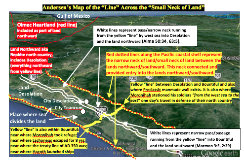
The Isthmus of Tehuantepec was not that narrow neck of land. It was not the small neck of land. And the “line” was not located within the isthmus. It is comforting to note that Kirk Magleby is now of the same basic opinion.7 Because the land Desolation, and therefore the Jaredite land northward, began at that “line,” then all the Isthmus of Tehuantepec was, in fact, the very heartland of the Jaredites, which encompassed and included all of the heartland of the Olmec.
The above analysis is in compliance with the wording, intent, and directions contained in the Book of Mormon and does not violate the archaeological and anthropological evidence of the area; rather the evidence is corroborated by it.8
Notes
1. Noah Webster, An American Dictionary of the English Language (New York: S. Converse, 1828), s.v. “isthmus.”
ISTHMUS, noun: A neck or narrow slip of land by which two continents are connected, or by which a peninsula is united to the mainland. Such is the Neck, so called, which connects Boston with the mainland at Roxbury. But the word is applied to land of considerable extent, between seas; as the isthmus of Darien, which connects North and South America, and the isthmus between the Euxine and Caspian seas (emphasis added).
2. See F. Richard Hauck, Deciphering the Geography of the Book of Mormon (Salt Lake City: Deseret Book, 1988), 12.
3. Webster, An American Dictionary of the English Language, s.v. “bountiful” and “small.”
4. My colleague Ted Stoddard explained this so very well in an email he sent to me August 2, 2010: “For centuries, the only reasonable way to get from Chiapas or Guatemala to Veracruz, Oaxaca, or the Mexico valley was to end up on the Pacific coast and go north through the Isthmus of Tehuantepec. About fifty miles into the isthmus, the topography opens up, permitting travelers to continue to Veracruz or to follow trails into the mountains and thence to the Oaxaca or Mexico areas. In a similar vein, travelers from the east wilderness (lowland jungle area of the Peten and Belize) or from the east sea (Caribbean off the coast of Belize) could not travel due west to go through the top of the isthmus because of (1) the mountainous terrain, especially in the Hermounts region at the top of and east of the isthmus, or (2) the marshy lagoons and rivers of Tabasco that made east-west travel almost impossible until the arrival of modern highways.”
5. If the “line” was an extension of the continental divide where the Sierra Madre crosses the Chivela Pass, then that “line” did not commence or end on the west sea, and there is no definition of the “line.” If the narrow pass was the Chivela Pass, then it did not run by the west sea. If the narrow pass was the Chivela Pass, then everything south of that pass would be the west-sea Bountiful and, therefore, only the northern half of the isthmus would be the small neck of land dividing the land northward from the land southward. Such logic, locations, and directions just do not conform to the Book of Mormon.
6. Hauck, Deciphering the Geography of the Book of Mormon, 12.
7. Kirk Magleby, “Book of Mormon Recourses,” http://bookoformonresoures, (accessed May 8, 2015). Finally, someone of the stature of Kirk Magleby has also broken from the traditional narrow neck/small neck of land/isthmus theory and now also agrees with Hauck and Andersen that the “sea that divides the land” is actually on the Pacific coast and that the “line” that separates Desolation from Bountiful is located near the areas of Tonala and Horcones, Mexico. The following map shows Magleby’s 2015 position on this issue, which theory he also presented at the October 2014 BMAF conference. The difference between his map and the above is so minute as to be insignificant. I propose that Magleby’s fortified line is the same as the line between Bountiful and Desolation. The distance between these two lines is only about four miles, and therefore his proposal is certainly within the parameters required by the Book of Mormon with the result that I can accept what he is proposing on his map.
8. See my article, “Nephites Among the Epi-Olmec,” http://www.bmaf.org/Nephites_Epi-Olmec__andersen.