


Response to Jerry L. Ainsworth’s Article, “Identifying the Book of Mormon’s Narrow Pass”
necessarily represent the views of BMAF or The Church of Jesus Christ of Latter-day Saints.
Response to Jerry L. Ainsworth’s Article, “Identifying
the Book of Mormon’s Narrow Pass”
Copyright © 2015 by Joe V. Andersen
Editor’s note: BMAF encourages responses to articles posted on its website. This article is such a response. Its content does not necessarily reflect the thinking of BMAF, but its board of directors hopes that the response will foster additional analysis of the issues raised by both Jerry Ainsworth and Joe Andersen.
Initially, I had not intended to respond publicly to Jerry L. Ainsworth’s article about the Book of Mormon’s narrow pass.1 However, I frankly found so many misstated scriptures, inaccurate conclusions, and absurd conjectures in the article that I decided they should be identified and explained—obviously from my perspective.
Personally, I can’t underestimate the importance of insisting that all authors who write about the Book of Mormon accurately state what the book actually says. I respect Dr. Ainsworth and certainly agree with what he says in the preface of his book: “The Book of Mormon is more precise and more accurate than I had ever dared to believe.”2 Therefore, in discussing the subject of the archaeology of the Book of Mormon, I feel that all authors must be just as precise as Mormon and Moroni were and should use the same terminology in the same places as they did.
Although I disagree with much of what Jerry writes, this response article on my part is not so much about differing opinions as it is about the accuracy of what he claims the Book of Mormon says or does not say as presented in his article and book.
Jerry’s article from the BMAF website is given below in its entirety. At appropriate places, I have inserted my responses in the form of comments, suggestions, and corrections. For simplicity, clarity, and accessibility purposes, my responses always begin at the left margin, are formatted in a different font than that used for Jerry’s article, are highlighted via a shaded background, and are always preceded by my initials, “JVA.”
Identifying the Book of Mormon’s Narrow Pass
By Jerry L. Ainsworth
This article is the outgrowth of an evolving process that began March 24, 2003, while I was driving to Palenque, Mexico, with Esteban Mejia. I knew this trip would require us to drive through the Isthmus of Tehuantepec, which many people (myself included) accept as the narrow neck of land of the Book of Mormon.
In my book, The Lives and Travels of Mormon and Moroni, I indicated that the narrow pass began in the eastern section of the narrow neck, ending at the Pacific Ocean. A few other writers have taken the position that the narrow pass ran into the Gulf of Mexico and that people accessed the land northward via the northern part of the Isthmus of Tehuantepec. In my earlier studies of this geographical issue, I had considered the same possibility. However, once I visited this land adjacent to the gulf, I realized that the land was much too swampy to allow for passage into the land northward via the gulf side of the isthmus.
To garner information to support such a view about the narrow pass, while driving to Palenque, I decided to count the rivers and streams that ran north to the gulf through the Isthmus of Tehuantepec. The outcome would represent the number of rivers and streams anyone would have to cross to access the land northward through the northern end of the isthmus. I counted twenty-four rivers or streams in the land as described. Specifically, these rivers and streams are located between the cities of Coatzacoalcos and Villahermosa, Mexico.
After counting these rivers in the northern part of the isthmus, I then wondered out loud how many rivers there were on the Pacific (southern) side of the isthmus. While I contemplated this question, it dawned on me that if dozens of rivers ran north to the gulf and a similar number ran south to the Pacific Ocean, there must be a space close to the center of the isthmus where there were no rivers—a continental divide.
I concluded that if this were the case, then possibly that narrow section of land where there were no rivers might possibly be the narrow pass—a section of land where people could walk from the land southward to the land northward without having to cross a river—or at least fewer rivers.
I took this theory home with me and studied my many maps of Mexico to determine if such a theory was supported by my relief maps of that area. I found nothing on these maps that clearly supported such a view, although I did identify a few locations that could possibly meet the criteria of this narrow-pass theory.
I even located a number of cities in this area with the term “pass” in their names, but I did not find an obvious pass. I then knew that to resolve this issue, I would have to travel to the narrow neck and personally look at these possible locations. The rest of this article is a discussion of what Esteban Mejia and I discovered during that visit to the isthmus in September of 2003.
Relevant Definitions and Scriptures
Before presenting that experience, I wish to define a number of terms and present the scriptures that refer to the narrow pass and other boundaries related to this investigation.
Here are definitions, according to Noah Webster’s 1828 dictionary,3 which of course gives definitions of words as they were understood in 1829 and 1830 when the Book of Mormon was translated and published:
Pass, n. A narrow passage, entrance or avenue; a narrow or difficult place of entrance and exit; as a pass between mountains.
JVA: Noah Webster also adds the following as a second definition of “pass”: “A passage; a road.” Notice that this definition does not require the road to be between mountains.
Passage, n. Road; way; avenue; a place where men or things may pass or be conveyed.
Desolate, adj. Destitute or deprived of inhabitants; desert; uninhabited; denoting either stripped of inhabitants, or never having been inhabited; as a desolate isle; a desolate wilderness.
Desolation, n. A place deprived of inhabitants, or otherwise wasted, ravaged and ruined.
Following are three Book of Mormon references to the narrow pass:
And it came to pass that they [Moroni’s army] did not head them [the followers of Morianton] until they had come to the borders of the land Desolation; and there they did head them, by the narrow pass which led by the sea into the land northward, yea by the sea, on the west and on the east. (Alma 50:34)
JVA: Notice that the narrow pass was not between mountains and that one side of the pass was the west sea.
And he [Moroni] also sent orders unto him [Teancum] that he should fortify the land Bountiful, and secure the narrow pass which led into the land northward, lest the Lamanites should obtain that point and should have power to harass them on every side. (Alma 52:9)
And it came to pass that I [Mormon] did cause my people that they should gather themselves together at the land Desolation, to a city which was in the borders, by the narrow pass which led into the land southward. (Mormon 3:5)
The Book of Mormon contains only one reference to the narrow passage:
And the Lamanites did give unto us the land northward, yea, even to the narrow passage which led into the land southward. And we did give the Lamanites all the land southward. (Mormon 2:29)
Relevant references to the land of Desolation are the following, including those that explain why the territory was “desolate” and therefore received the designation of land of Desolation:
And it [Bountiful] bordered upon the land they called Desolation, it being so far northward that it came into the land which had been peopled and been destroyed, of whose bones we have spoken, which was discovered by the people of Zarahemla, it being the place of their first landing. (Alma 22:30)
And it came to pass that they [Moroni’s army] did not head them [Morianton’s followers] until they had come to the borders of the land Desolation; and there they did head them, by the narrow pass which led by the sea into the land northward, yea, by the sea, on the west and on the east. (Alma 50:34)
JVA: I prefer to add two more clarification comments in that scripture: “until they had come to [not in] the borders of the land Desolation; and there they did head them, by [but not in] the narrow pass . . .”
And it came to pass that Hagoth, he being an exceedingly curious man, therefore he went forth and built him an exceedingly large ship, on the borders of the land Bountiful, by the land Desolation, and launched it forth into the west sea, by the narrow neck which led into the land northward. (Alma 63:5)
And it came to pass in the forty and sixth, yea, there was much contention and many dissensions; in the which there were an exceedingly great many who departed out of the land of Zarahemla, and went forth unto the land northward to inherit the land. And they did travel to an exceedingly great distance, insomuch that they came to large bodies of water and many rivers. Yea, and even they did spread forth into all parts of the land, into whatever parts it had not been rendered desolate and without timber, because of the many inhabitants who had before inherited the land. And now no part of the land was desolate, save it were for timber; but because of the greatness of the destruction of the people who had before inhabited the land it was called desolate. (Helaman 3:3–6)
And the land which was appointed was the land of Zarahemla, and the land which was between the land Zarahemla and the land Bountiful, yea, to the line which was between the land Bountiful and the land Desolation. (3 Nephi 3:23)
And it came to pass that I [Mormon] did cause my people that they should gather themselves together at the land Desolation, to a city which was in the borders, by the narrow pass which led into the land southward. (Mormon 3:5)
And now it came to pass that in the three hundred and sixty and third year the Nephites did go up with their armies to battle against the Lamanites, out of the land Desolation. (Mormon 4:1)
And it came to pass that the armies of the Nephites were driven back again to the land of Desolation. And while they were yet weary, a fresh army of the Lamanites did come upon them; and they had a sore battle, insomuch that the Lamanites did take possession of the city Desolation, and did slay many of the Nephites, and did take many prisoners. (Mormon 4:2)
And it came to pass that the Lamanites did come down against the city Desolation; and there was an exceedingly sore battle fought in the land Desolation, in the which they did beat the Nephites. (Mormon 4:19)
Here are the references to a day’s journey, a day and a half’s journey, and the line between the land Bountiful and the land Desolation:
And there [the land of Bountiful] they did fortify against the Lamanites, from the west sea, even unto the east; it being a day’s journey for a Nephite, on the line which they had fortified and stationed their armies to defend their north country. (Helaman 4:7)
And now, it was only the distance of a day and a half’s journey for a Nephite, on the line Bountiful and the land Desolation, from the east to the west sea. (Alma 22:32)
And the land which was appointed was the land of Zarahemla, and the land which was between the land Zarahemla and the land Bountiful, yea, to the line which was between the land Bountiful and the land Desolation. (3 Nephi 3:23)
Conclusions about Territory near the Narrow Pass
Following are conclusions that can be drawn from the preceding definitions and scriptures:
- There is both a pass as well as a passage through which people had to travel, indeed something like a gateway, from the land northward to the land southward, or vice versa.
JVA: In fact, the Book of Mormon contains at least four references to this “gateway.”4
1. “The narrow pass which led by the [west] sea into the land northward, yea, by the sea on the west” (Alma 50:34).
2. “Hagoth . . . built him an exceedingly large ship, on [within] the borders of the land Bountiful by [near but not in] the land Desolation, and launched it forth into the west sea, by [near but not in] the narrow neck which led into [did not divide] the land northward” (Alma 63:5).
3. “And the Lamanites did give unto us the land northward, yea, even to [not in] the narrow passage which led into the land southward. And we did give unto the Lamanites all the land southward” (Mormon 2:29). [This “treaty” included the narrow passage that led into the land southward because the narrow passage was part of the land southward.]
4. “And it came to pass that I did cause my people that they should gather themselves together at the land Desolation [therefore near the west sea], to a city [Desolation] which was in the borders [of land Desolation], by [but not in] the narrow pass which led into the land southward” (Mormon 3:5).
- This pass and passage separated the land southward and land northward as divided by Mormon in AD 350.
JVA: This is an incorrect statement. Mormon did not use the term “pass” in Mormon 2:29. He never used these two terms together and never said that they separated the land southward from the land northward. He never said that the “narrow neck” in Alma 63:5 separated anything. And Moroni never said that the “narrow neck of land” in Ether 10:20 separated anything.
The only times that Mormon said that something “divided” or “separated” anything near the west sea were (1) in Alma 22:32, “a small neck of land between the land northward and the land southward,” (2) in 3 Nephi 3:23, “to the line which was between the land Bountiful and the land Desolation,” and (3) in Alma 22:32, “it was only the distance of a day and a half’s journey for a Nephite, on the line Bountiful and the land Desolation, from the east to the west sea.”
- Apparently, the pass and the passage were two separate places.
JVA: You should show from the Book of Mormon where it is apparent that the two were located in separate places.
- In that respect, Mormon was very precise in what he wrote.
JVA: Certainly he was precise in not using the word “pass” when he referenced the treaty line. He used only the word “passage.” That passage began at the “line” between Desolation and Bountiful, which “line” was also the dividing line between the land northward and the land southward. This “line” was located within the “small neck of land” and ran a distance of about fifteen miles east from the west sea. That passage (aka pass) that began at the “line” and led into the land southward was also a part of the land southward that Mormon gave to the Lamanites/robbers in the treaty of AD 350.
- The land Desolation was a segment of land that was unfit for and devoid of habitation—a wasteland.
JVA: The Book of Mormon does not confirm this statement. In fact, it says the very opposite. That is, Desolation was a part of the land northward. Ether10:21 says, “And they did preserve the land southward for a wilderness, to get game. And the whole face of the land northward was covered with inhabitants.” The land Desolation bordered the land Bountiful at the “line,” and all three locations started at the same location on the west sea. Northward of that “line” was located the Jaredite land northward within which was located the land Desolation. Within Desolation was located the city Desolation and the city Teancum. How was that “unfit for and devoid of habitation and a wasteland?” It was called Desolation by the Nephites, but that certainly does not mean it was “unfit for and devoid of habitation—a wasteland.” It means only that (1) at one time there was a decimation of a civilization at that location or (2) it was a drier land than the land Bountiful and perhaps at one time had no timber.
- The land Desolation bordered the land Bountiful on the east,
JVA: This is not factual. According to the Book of Mormon, the “line” between Desolation and Bountiful went in an east-to-west direction, the land Desolation was northward from that line, and the land Bountiful was southward from that line. How is that east? If Mormon was “very precise” in what he wrote, then we must be at least as precise as he was and should use the terms he used:
“Thus the land on the northward [of the line; see verse 32] was called Desolation, and the land on the southward [of the line] was called Bountiful, it [land Bountiful] being the wilderness which is filled with all manner of wild animals of every kind, a part of which had come from the land northward [including land Desolation] for food” (Alma 22:31).
whereas Desolation’s west border extended from the western side of the isthmus
JVA: The only western border of Desolation mentioned in the Book of Mormon is the west sea. The Book of Mormon says nothing about an isthmus.
into the land northward so far that it came to the location of the final battle of the Jaredites.
JVA: This is another misstatement of the facts. It does not say the location of the final battle of the Jaredites. It says only that the land Desolation “came into the land which had been peopled and been destroyed” (Alma 22:30). This could have been anywhere within the isthmus (or within the Jaredite land northward) because the fighting had been going on for fourteen years among the Jaredites, and it traversed the major population centers of the entire land northward.
That is the same location where the forty-three soldiers of King Limhi discovered the remaining bones of that battle as well as the twenty-four plates of Ether. (Depending on where an analyst considers the land of Cumorah to be, the land of Desolation extends that far northward.
JVA: This again is not factual. It does not say that Desolation extended into the land of Cumorah. The Book of Mormon does not tell us what part of the land northward the forty-three scouts found. The Jaredite land northward was a very large area. Mormon does not tell us that these scouts traversed the entire Jaredite land northward. It does not tell us that the forty-three scouts found the plates at the location of the final battle but only that Ether “hid them in a manner that the people of Limhi did find them”(Ether 15:30).
- The border
JVA: It does not say “border”; it says “line.” We should be as precise as Mormon.
that separated the land Desolation from the land Bountiful began at the west sea (Pacific Ocean), went north, and then turned east,
JVA: Where in the Book of Mormon can it be shown that the border (line) went north before turning east? It says from the “east to the west sea.” That direction is westerly, not north.
but the border
JVA: “Line,” not “border.”
did not reach the east sea.
JVA: Alma 22:30.
- A Nephite required a day and a half to walk the complete border that separated the two lands of Bountiful and Desolation.
JVA: Another misstatement. It does not say “complete border that separated the two lands of Bountiful and Desolation.” It says, “only the distance of a day and a half's journey for a Nephite, on the line bountiful and the land Desolation, from the east to the west sea” (Alma 22:32). And then in Helaman, it says, “And there they did fortify against the Lamanites, from the west sea, even unto the east; it being a day’s journey for a Nephite, on the line which they had fortified and stationed their armies to defend their north countries” (Helaman 4:7).
- This boundary that separated Desolation and Bountiful is referred to as “a line.”
JVA: True. Therefore, let’s use Mormon’s terminology and refer to it as the “line” and not “border” or “boundary.”
- The portion of this border/line separating Bountiful and Desolation, which required fortification to keep Lamanites from entering the land Desolation, took a day for a Nephite to walk. Presumably one-third of the border, a half day’s walk, did not require fortification.
JVA: True. And perhaps by this time (ca. 35 BC) the “line” had become more passable with use. Mormon emphasized “precisely” that the “line” went from the west sea eastward, not north.
Scriptures about Cities Associated with the Land Desolation
Following are scriptures indicating cities in, or close to, the land of Desolation:
And it came to pass that I [Mormon] did cause my people that they should gather themselves together at the land Desolation, to a city which was in the borders, by the narrow pass which led into the land southward.
And there we did place our armies, that we might stop the armies of the Lamanites, that they might not get possession of any of our lands; therefore we did fortify against them with all our force.
And it came to pass that in the three hundred and sixty and first year the Lamanites did come down to the city of Desolation to battle against us; and it came to pass that in that year we did beat them, insomuch that they did return to their own lands again.
And in the three hundred and sixty and second year they did come down again to battle. And we did beat them again, and did slay a great number of them, and their dead were cast into the sea. (Mormon 3:5–8)
And it came to pass that the armies of the Nephites were driven back again to the land of Desolation. And while they were yet weary, a fresh army of the Lamanites did come upon them; and they had a sore battle, insomuch that the Lamanites did take possession of the city Desolation, and did take many prisoners. And the remainder did flee and join the inhabitants of the city Teancum. Now the city Teancum lay in the borders by the seashore; and it was also near the city Desolation. (Mormon 4:2–3)
And it came to pass that the Lamanites did make preparations to come against the city Teancum. And it came to pass in the three hundred and sixty and fourth year the Lamanites did come against the city of Teancum, that they might take possession of the city Teancum also. And . . . [the Nephites] took possession again of the city Desolation. (Mormon 4:6–8)
And it came to pass that the Lamanites did take possession of the city Desolation, and this because their number did exceed the number of the Nephites. And they did also march forward against the city Teancum, and did drive the inhabitants forth out of her, and did take many prisoners both women and children, and did offer them up as sacrifices unto their idol gods. (Mormon 4:13–14)
And it came to pass that the Lamanites did come down against the city Desolation; and there was an exceedingly sore battle fought in the land Desolation, in the which they did beat the Nephites. (Mormon 4:19)
Conclusions about Cities near the Narrow Pass
Conclusions that can be derived from the above scriptures, related to cities, are as follows:
- Mormon mentions two cities in, or close to, the land of Desolation—the city Desolation and the city Teancum.
JVA: They were both actually within the land Desolation and very near the “line” and adjacent to the west sea and not in the Monte Alban area in the mountains (see the map at the end of this article).
- Neither of these city names appears until after AD 350 when the lands were divided between the Nephites and Lamanites at the narrow pass.
JVA: This is another incorrect statement. Mormon 2:29 does not use the term “pass.” It says “even to [not in; this wording describes the beginning of the narrow passage at the treaty line] the narrow passage which led into the land southward. And we did give unto the Lamanites all the land southward” [from where that passage began at the treaty line and southward, including the passage]. (Mormon 2:29; emphasis added) Had you said that the lands were divided “at the beginning of the narrow passage that led into the land southward” (in other words, at the "line"), then I would agree.
- The cities are mentioned by name only after the Nephites possessed that land.
- The city Desolation was in the western border of the land Desolation
JVA: Where does this information come from? It does not say “western border.” Mormon 3:5 says, “I did cause my people that they should gather themselves together at the land Desolation, to a city which was in the borders [of Desolation], by [not in but near the beginning of line of] the narrow pass which led into the land southward.” This could have been only in the southeastern boundary of the land Desolation at the “line” between Desolation and Bountiful that divided them and very near the west sea.
in the land northward. The city Desolation was in the land given to the Nephites after the division of land in AD 350.
- The city Desolation was very well fortified.
- The city Desolation was located in the lowlands, as the Lamanites always went down to it.
JVA: And the bodies of the dead Lamanites were tossed into the west sea in the battle of AD 362. Then why does it show on your map at page 75 of your book that the city Desolation is located near Monte Alban in the mountains?
- The city Teancum was close to the city Desolation, while being in the land Desolation proper.
JVA: Both were in the land Desolation proper because the definition of the land Desolation was from the Nephite west sea (aka Jaredite south sea) northerly and “northward” from the fifteen-mile-long “line” running east to west. Both city Teancum and city Desolation were located close to the “line,” close to the west sea, and close to each other; therefore, both were located in the land Desolation proper.
- The city Teancum was close to, or on, the seashore (Pacific Ocean). Later in this article, I will develop the idea that this location may be the meaning of the name Teancum.
- Numerous and significant battles took place in and around the two cities of Teancum and Desolation. Lamanites killed in these battles were cast into the sea,
JVA: Another misstatement. It does not say “these battles.” There were five battles defending city Desolation, but only one battle, AD 362, is identified as the one where the bodies were cast into the sea.
so these cities were close to the ocean.
- Apparently, of the two cities the Lamanites were trying to control (the cities of Desolation and Teancum), the city Desolation was the more important. I assume the reason for this strategy was that the city Desolation was more strategically located than Teancum.
Journey to the Isthmus
Given our conclusions as set forth above, Esteban Mejia and I drove to the Isthmus of Tehuantepec where we explored locations during the first week of September 2003. Specifically, we intended to determine the location of the narrow pass, the narrow passage, the cities Desolation and Teancum, and the boundaries of the lands Desolation and Bountiful.
It may be helpful to mention how we proceeded to locate the specific sites we were searching for—the narrow pass, the borders of Desolation, and the cities of Desolation and Teancum.
We used four sources of information for this investigation—the Book of Mormon itself, relief maps of Mexico along with historical and archaeological maps and descriptions of the territory, interviews with people of the isthmus, and personal, on-the-ground investigations. We specifically spoke with archaeologists who were working at sites in this area as well as with many “old-timers”—those who could tell us why they built a road or train track in a certain location (that is, did the builders follow an ancient route or pass?).
It should also be of interest to mention that Esteban and I have discovered that current borders of states, countries, and so forth frequently conform to, or approximate, ancient political borders. For example, the northern border of the state of Chiapas, Mexico, probably conforms to or approximates the northern border of the land Bountiful in the Book of Mormon. This rationale may also be true for the western border of the state of Chiapas.
Our first day of driving took us from Puebla, Mexico, to the small town of Matias Romero, Oaxaca, where we spent the night. Before going to bed, we spoke with the owner of the hotel (Hotel Real Istmo) and asked him if he knew anything about the areas we were interested in. He mentioned that Mexico was building a new road in the southern part of the isthmus, and while doing so, the construction workers had run into some ancient ruins that required a diversion of the road. He suggested that we visit the Casa de Cultura in Ixtepec for that information.
The following day we drove to Ixtepec (forty meters above sea level), and while searching for the Casa de Cultura, we discovered a place where workers were putting together broken pottery from the ancient site the new road had encountered. While speaking with the people working on this pottery, we were introduced to the archaeologist in charge, Gloria Bifano. She provided us with additional information about other ancient sites in this area
She indicated that in the early 1930s, a number of sites in the isthmus had been discovered and explored—but never excavated. When sites are excavated and left unattended, they degrade rather rapidly—much more so than if they are left covered by growth. Because the isthmus is not a tourist area, there was little incentive to excavate these sites. However, we were told that the record of these early excavations was housed in the Casa de Cultura if we wished to read them.
Gloria mentioned two sites in particular. One was a site close to the city of Juchitan (eighteen meters above sea level), which was named El Basurero because it was discovered close to the city garbage dump. Archaeologists have since provided the name of Lagua Zope for this site.
The Hike to Guingola
The second site was at the foothills of the Sierra de Mixes, which is about eight miles west of the city of Tehuantepec. The name of this site is Guingola, which means “split rock.” The site, which has the traditional pre–Columbian public buildings and pyramids, is located halfway up a very steep hill. Treacherous cliffs and ravines flank it, and the rest of the city boundaries has a large stone fortification that protects it.
Guingola is located at the entrance of the highway into the highlands of Mexico (the land northward). It is strategically located to protect/control access to this major thoroughfare. Very little of this site has been excavated, although the large public buildings are visible.
In Book of Mormon language, this city is located in the borders of the land Desolation and is a perfect candidate for the city of Desolation.
When we drove to this site, we had breakfast with a family that lives at the base of the hill upon which the site is located. The father of this family acts as an unofficial guide to the few who visit the site. Because Esteban is a licensed guide in Mexico, they developed an immediate friendship, and he shared many things with Esteban and me.
We then ran into the National Institute of Anthropology and History archaeologist who is working at the site, and he shared with us what he knew about the area. He indicated it was a Preclassic site (around 300 BC) that was inhabited throughout Classic and Preclassic times.
This site was still inhabited when the Aztecs were conquering the pre–Columbian cultures of southern Mexico. The Aztecs laid siege to the site of Guingola for sixty days but were unable to conquer it. They therefore abandoned their assault of Guingola. This battle marked the southernmost part of their conquest, which kept the Aztecs from conquering the Maya of the Peten area and the highlands of Guatemala.
When visiting the Casa de Cultura, we were told of the two typed papers that contained the history of the early exploration of these sites. We therefore had them make photocopies of these papers for us.5
Guingola is located about eight miles northwest of the city of Tehuantepec. We were also told of a Preclassic ruin site close to the city of Juchitan, which is about twenty-five miles northeast of Guingola. Whereas Tehuantepec is about fifty meters above sea level, Juchitan is only eighteen meters above sea level. During the short time we were in this area, we were led to believe that the ruin site close to Juchitan would have been on the coast during Book of Mormon times.
These two ruin sites appear to meet the criteria to be considered the cities of Desolation and Teancum. Guingola (our candidate for Desolation) is located at the location that would be considered the borders of Desolation and the land northward. The ruin site close to Juchitan meets most of the criteria for the city of Teancum. Of these two sites, Guingola is much more strategically located than the other and is very well fortified.
As indicated in my book, The Lives and Travels of Mormon and Moroni, I believe the term ancum is Jaredite for “ocean.”6 In the Zapoteca Mayan language, Te or Ta indicate the end of something. Teancum could, therefore, mean the city that was located at the end of the ocean (on the coast of the Pacific Ocean).7
While driving back to Ixtepec, we were surprised to find that the major highway had been blocked and therefore closed down by demonstrators. Trucks were backed up for miles, and when we asked how long such a protest could last, we were told “possibly days.” It was just our luck to run into a small revolution during our search. We were, however, successful in finding an old dirt road that bypassed the closed highway.
Riding a Locomotive through the Chivela Pass
The following day, we visited the train station in Ixtepec, as we were told that the train tracks had been laid through a small pass that ran through the small mountain range bisecting the Isthmus of Tehuantepec, making passage of the area difficult.
This small mountain range is called Sierra Atravesata.
JVA: The correct spelling is Atravesada.
The term Atravesata comes from the Spanish word Atravesar, which means to be in the way or to block a way or a path.
JVA: More correctly, it means “to cross over or to go from one side to the other.”
This range of mountains runs east to west and traverses the narrow neck. To travel from the Book of Mormon land southward to the land northward, Book of Mormon travelers had to pass through, or go over, this mountain range. Therefore, the obvious thing to look for was a pass through this mountain range, which was the purpose of our questions to many people we spoke with. The Sierra Atravesata averages 250 meters in height, and the highest point is 650 meters.
It became obvious to us that there are currently only two passes through this mountain range. One was the route the highway followed, which had some steep climbs and descents to it. The other was the pass the train track followed. This track was laid via a very narrow and meandering pass through the Sierra Atravesata.
We then tried very hard to rent a plane to fly us over this area. To do so, however, required our having to fly to the area from many miles away. The plane would have had to land at a militarily controlled airport and would have cost thousands of dollars. We gave up on that idea and decided to see if we could persuade those who ran the train to take us instead.
We therefore spoke to the man in charge of the train station in the city of Ixtepec. The trains are not passenger trains but are cargo units only. Ixtepec was one of the switching stations. Esteban, in his magical way, convinced the jefe of the trains to allow me to ride on the front of the locomotive, taking pictures of the narrow pass as the train went through it, a distance of about twelve miles (twenty-one kilometers).
I therefore took my two cameras, climbed on the front of the locomotive, and was able to have a clear view of the narrow pass as the train snaked through it. It had many twists and turns but did indeed pass through the lowest areas of the Sierra Atravesata. The train track itself was halfway up the sides of the small pass, as there was a small stream at the very bottom of the pass. There was so much growth in the bottom of the pass that it was difficult to actually see if there was an ancient path there.
At some point, I wish to return and walk those twelve miles to see if there are remnants of an ancient path. As things stand right now, this is the best candidate I know of for the narrow pass mentioned in the Book of Mormon.
The pass actually begins at a small town named Mena and ends twenty-one kilometers later at a place called Chivela. At this small town, the engineer stopped the train and dropped me off—in someone’s back yard, I might add. I stayed there until Esteban picked me up, as he had driven the distance on the highway and then cut over to the little town where I was dropped off.
The pass was very different from what I had always envisioned, but it did meet the criterion of being a narrow pass that leads from the land southward into the land northward. The pass is rather shaped like an “S”; and, as odd as it may sound, to go through this pass into the land southward, travelers must travel north for some distance. To take the pass into the land northward, travelers must travel south.
The Wider Corridor beyond the Pass
Once travelers are through this narrow pass, there is a wider corridor—a narrow passage—that continues to run north for another fifteen to twenty miles. It is not necessary to stay in that corridor, as travelers can turn east as soon as they come out of the narrow pass and then travel into the land Bountiful. However, Mormon mentions that the narrow passage served as the boundary for Mormon’s division of the land with the Lamanites in AD 350.
JVA: This conclusion is totally illogical because the Book of Mormon clearly describes only one “passage” that went from the “line” southward into the land southward. And it does not say that a Nephite must travel northward through a pass and then farther northward through a wider corridor called a “narrow passage” to get into the land Bountiful. Clearly, Desolation, Bountiful, and the line between them all began at precisely the same point on the west sea, not at the Chivela pass. Further, Mormon does not mention that the narrow passage served as a boundary for the division of the land with the Lamanites. The narrow passage did not divide anything; it only led into the land Bountiful. It was the “line” that divided the lands; therefore, the narrow passage that led into the land southward must have started at the “line.”
At the time Mormon wrote this, I assume that the narrow pass went from the Pacific Ocean to the other side of the Sierra Atravesata mountain range. At the end of that pass, a narrow passage (bounded by low hills) then continued through the marshland toward, possibly to, the Gulf of Mexico. These two passages, going from ocean to ocean, provided a clear boundary between the lands of the Nephites and Lamanites, as agreed to in AD 350.
JVA: This is conjecture with no support in the Book of Mormon. Apparently, the claim here is that, after the AD 350 treaty, the entire eastern half of the Isthmus of Tehuantepec (from the line that went north to south from the north sea to the south sea) belonged to the Lamanites, and the western half belonged to the Nephites? And that boundary is “clear”? “definable”? and “defensible”? And that “line” boundary goes due north to south instead of east to west, as required by the Book of Mormon? Also, the ruins in and around the city of Tehuantepec and Salina Cruz were under water during Book of Mormon times? The line being described is 150 miles long, not 35.
Assuming we have located the narrow pass and narrow passage, the distance for this demarcation of the lands southward and northward was about thirty to thirty-five miles. This was more than likely also the width of the narrow neck (at its most narrow place) during Book of Mormon days—especially because travelers could walk the line
JVA: The line that goes east to west or north to south?
that divides Bountiful and Desolation in a day and a half, a distance of about thirty-five to forty miles (see Alma 22:32).
JVA: I am totally confused. Is this narrow pass and narrow passage going north to south, from sea to sea, the line of demarcation between the land northward/southward or the line of demarcation between the Lamanites and the Nephites following the AD 350 treaty? If it is the former, then the land northward would have been directly west of that line instead of northward, and the land southward would have been directly east? If it was the latter, then the Lamanites would have controlled the area of La Venta on the Gulf of Mexico to the west sea, controlling Tonala, Arriaga, and Hildago areas, and the Nephites would have controlled the Juchitan, Tehuantepec, and Salinas Cruz areas on the west sea to Coatzacoalcos on the Gulf of Mexico? The distance of this boundary line is 150 air miles. Most of these areas were in existence during the Late Preclassic. The postulations here must be that the entire area of the Tehuantepec plain was inundated and that most of the Gulf of Mexico side of the Isthmus (the entire heartland of the Olmec) was inundated, including most of San Lorenzo, La Venta, Tres Zapotes, Minatitlan, etc. Is that what is being proposed? That is what your maps show: No. 13 on page 96; No. 16 on page 10; and No. 21 on page 130 of your book. The archaeology of these areas shows that they were in existence during the Book of Mormon time frame and therefore were not inundated. How is this any different than living in an area like New Orleans that gets flooded all the time and yet people live there?
Two Possibilities for the Narrow Pass
Assuming I am correct about the Isthmus of Tehuantepec being the narrow neck,
JVA: Is it your position that the Isthmus of Tehuantepec is the narrow neck of land, the narrow neck leading by the west sea into the land northward, and the “small neck of land” between the land southward-land northward? Are they all the same thing? Is the narrow pass, therefore, the same thing as the small neck of land? Did Mormon use all four names for the same location?
two possibilities have been put forth related to the narrow pass in this narrow neck.
Some argue that the whole area of the Sierra Atravesata, a small mountain range that bisects the narrow neck, is the narrow pass mentioned in the Book of Mormon. This designation would mean that the narrow pass would actually be the total area between the mountain range east of the isthmus and the mountain range west of the Isthmus. Given this interpretation, the pass would be around sixth miles wide, and a person could pass through it at almost any location along that sixty–mile width. Such a view would mean that the term “narrow pass” would be a relative term, meaning narrow in relation to the other parts of the Nephite/Lamanite territories. This argument essentially says that the narrow neck is the narrow pass.
I do not believe this is the case because . . .
- The narrow pass, combined with the narrow passage, constituted the boundary that separated the Nephite and Lamanite territories in the treaty of AD 350 (see Mormon 2:29).
JVA: How is that possible? This scripture does not even mention a narrow pass. The “passage” in verse 29 leads only from the “line” into the land southward. Where can you support the proposition from the Book of Mormon that the narrow pass that led into the land southward was different from the narrow passage, that they sequentially combined to form the boundary that separated the lands northward/southward, and that both the passage and the pass went in a north-to-south direction?
Given that, it is difficult to believe that the dividing boundary was sixty miles wide.
- The ocean,
JVA: Which ocean?
during Book of Mormon times, came inland so as to reach the foothills of the Sierra Atravesata.
JVA: You should show some scientific evidence about how far inland the ocean went and when and which ocean. Such a statement without corroborating information is pure conjecture and is unbelievable.
In such a case, crossing the mountain range at the wrong location placed travelers at the foothills of the mountains, descending directly into the ocean. This scenario made it next to impossible for travelers to then travel westward along the ocean/mountain interface
JVA: How can you possibly know what the terrain was at that time period? The statements reflect sheer guesswork with no Book of Mormon corroboration.
to the route that leads into the highlands of Mexico, the land northward.
JVA: I presume you are talking about the Jaredite land northward? How can the highlands of Mexico have been the Jaredite land northward when the archaeological and anthropological evidences point more directly to the area of the Olmec heartland as a major part of the heartland of the Jaredites? No other area has this kind of archaeological and anthropological support. And clearly the Jaredite people were destroyed in the same area where they “had been peopled and been destroyed” (Alma 22:30).
I am, therefore, left with only one option—an actual narrow pass that runs through the Sierra Atravesata, emptying close to the route that leads to the route to the highlands of Mexico. Such a narrow pass appears to be the most likely option to me. I believe the narrow pass is indeed the narrow area through which the train track runs, from Mena to Chivela, Oaxaca, Mexico. I also believe the narrow passage is a corridor that begins at Chivela (north end of the narrow pass) and runs due north for about twenty miles. This passage then runs directly into the swamplands that were known as Tlapalco in pre–Columbian days, possibly extending all the way to the Gulf of Mexico.
JVA: The information in the preceding paragraph is absolutely contrary to what the Book of Mormon requires.
The Line That Separates Desolation and Bountiful
Mormon refers to the boundary that separates the lands Desolation and Bountiful as a “line.” As hard as I have tried, I cannot locate any geographical demarcation of this area (river, mountain range, etc.) that constitutes a “line.” There may be one, but I cannot locate any candidates on a map of Mexico.
JVA: A logical option for the “line” is the defensive wall that was located near Horcones, Mexico. This manmade wall was constructed in the Late Preclassic Period, and it provided a defensive line connecting hills from the west sea, from the Pacific, eastward to the Sierra Madre Mountains, as required by the Book of Mormon.
However, the boundary that currently separates the states of Oaxaca and Chiapas does run in a rather straight line, from south to north, and then turns east, just as the Bountiful/Desolation line mentioned in the Book of Mormon does.
JVA: The Book of Mormon does not say that the “line” ran north to south and then turned east.
I do not know why the boundary that separates these two states takes this linear route, but given no acceptable alternative, I am prepared to accept this line as the ancient line that separated Bountiful and Desolation.
JVA: That analysis absolutely violates what the Book of Mormon requires.
Assuming the ocean extended from the current coast inland, so as to reach the mountain ranges as I believe, the distance of this line, from the ocean to the east swamp,
JVA: Shouldn’t that be the “north swamp”?
is about the distance a Nephite could walk in a day and a half (around thirty-five to forty miles).
JVA: I recommend that you show this on a Google map and then discuss archaeological evidence to support it. I do not understand what you are suggesting.
Therefore, again, I believe the “line” that separated the lands Bountiful and Desolation is essentially the same line that separates the states of Chiapas and Oaxaca today.
After writing the above observations, I studied the matter for weeks, finally referring to archaeological maps that mark the easternmost boundary of the Maya nation. Every map I consulted drew the same boundary as mentioned above, an artificial line that traverses mountains, being the same location as the boundary that separates the states of Oaxaca and Chiapas. And finally I figured out that this line, the boundary between these two states, appears to make no sense at all at first glance.
JVA: With those aspects of the analysis in mind, analysts will realize that the boundary makes even less sense after second and third analyses because the Maya did not go into the isthmus. For corroboration of that fact, I suggest a review of the map that Michael Coe and Stephen Houston use to detail the limits of the Maya area.8 As that map and related discussion point out, the western limits of the Maya neither extended into the central depression of the state of Chiapas in Mexico nor into the territory of the Isthmus of Tehuantepec.
As shown in my book, The Lives and Travels of Mormon and Moroni,9 the Lamanites (highland Maya) were ceded the tops of the mountains for their nation,
JVA: When? If the discussion involves the time of the treaty of AD 350, then the statement is incorrect because the Book of Mormon contains no evidence of any city building by the Lamanites, let along in the “tops of the mountains.” The Lamanites were fighting a war of extermination rather than building cities on the tops of mountains. If the discussion here involves that same timeframe, then the Lamanites, according to the logic of the above sentence, were inhabiting the eastern half of the isthmus, which was mostly in the lowland, except for the Chimalapas where no group of people has ever lived.
where they built their major cities. The Nephites (lowland Maya) were ceded the lowlands.
JVA: No historical evidence exists to show that the lowland Maya ever conquered or populated the Isthmus of Tehuantepec.
The lands between these geographical opposites were, by agreement,
JVA: What agreement? Such a statement should be supported with a reference from the Book of Mormon.
not developed, either by the Nephites or the Lamanites. These mountain slopes were viewed as wilderness and were occupied by the Gadianton robbers (see 3 Nephi 1:27).
JVA: Where in the world, or rather in the Book of Mormon, can such an unsupportable conjecture be derived? And while you are using such unsupportable conjecture, where in the Book of Mormon can support be found for the following statement on page 166 of The Lives and Travels of Mormon and Moroni: “Moroni would have been a small child at this time [AD 362] and was probably enrolled in the school of scribes in Moron”?
This “treaty” is implicit in the Book of Mormon but never stated as such.
JVA: An “explicit” treaty is found in Mormon 2:28. However, the terms as suggested in your article, “Identifying the Narrow Pass of the Book of Mormon,” are not even “implicit.”
However, the same distinction appears to have existed between the highland Maya (Lamanites) and the lowland Maya (Nephites). In both cases, the westernmost boundary of these two nations appears to have been at the same location. The question is why at that location?
JVA: Can we say that this westernmost boundary of the two Maya nations was the western side of the isthmus? Even if that westernmost boundary was the proposed north-south “line” dividing the Isthmus, it is an incorrect statement because the Maya were not located farther west than about Palenque. Even many of the settlements on the west coast were not considered Maya. The lowland Maya area is considered to be located in the Peten, Belize, and Yucatan Peninsula areas, and the highland Maya are those located in the mountainous areas of Guatemala and southern Mexico—but not near the Isthmus of Tehuantepec. Can we claim that all the lowland Maya, including those at El Mirador and Tikal, were Nephites? If so, we should provide support that these Maya were conquered by or converted by the Nephites.
The answer to this question lies in the conundrum these two enemies faced. The narrow neck, the land Desolation, had a modest amount of both of the characteristics dividing the nations. The narrow neck was composed of a mountain range as well as a significant portion of lowlands. The mountain range, Sierra Atravesata, already mentioned, was a very low mountain range that ran transverse to the mountain ranges that surrounded the central basin of Mexico.
If the Lamanites were to be granted the tops of all the mountains
JVA: Again, where can you possibly support this conjecture in the Book of Mormon?
and if the narrow neck were part of this treaty, then they would have controlled the mountainous part of the narrow neck, which would grant them control of the exit/entrance of the land southward. Under these circumstances, the Lamanites would occupy and control three of the Nephite boundaries, the fourth boundary being the ocean.
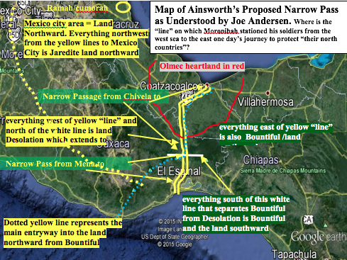
JVA: I suggest a map so readers can understand precisely the features of your proposed Book of Mormon geography in your article. Does the following map reflect correctly the geography of this article? Some aspects of this article and map seem to be substantially different than the Book of Mormon geography of your book, The Lives and Travels of Mormon and Moroni.
Given those choices, the Nephites must have arranged to have the Lamanite/Nephite territories end where these lands buttressed the Sierra Atravesata.
JVA: The correct name is Atravesada.
Under these conditions, the line that separates Bountiful from Desolation would be an artificial line that separates one mountain range, Atravesata, from the mountain ranges where the Lamanites were deeded the top portion.
JVA: Incredible! How could anyone “deed” the top portion of a mountain range, especially in AD 350?
Apparently, this Book of Mormon line/boundary continued after the demise of the Nephite nation in AD 385 and was still in use during the Classic Period of the Maya nation.
JVA: What support do you have for this statement?
This same boundary appears to have been adopted as the separation of the states of Oaxaca and Chiapas of Mexico.
JVA: This line is 150 air miles long—not 35!
Boundary of the West Side of the Land Desolation
The western side of the land Desolation is never mentioned in the Book or Mormon, as it does not relate to lands occupied by the Nephites and so forth. The only references in the Book of Mormon indicate that fortified cities were close to, or at, this western boundary and that the land Desolation extended into the land northward far enough to reach the boundaries of the land where the final Jaredite battle took place, the land called Cumorah by Mormon (see Alma 22:30).
JVA: The Book of Mormon in Alma 22:30 does not say that Desolation extended far enough into the land northward to reach the boundaries of the land where the final Jaredite battle took place at Cumorah. It says only until it “came into the land which had been peopled and been destroyed.” The Jaredite land northward was a huge area that took fourteen years of civil war to destroy all those Jaredites participating in that devastating war. The Book of Mormon does not say which part of that land the forty-three scouts found.
Realizing how far this land/hill Cumorah was from the land Desolation itself, I was always confused by this particular facet of Desolation. I simply could not appreciate how Desolation could extend that far into the land northward, even given the concept of “desolate” implying the absence of trees (see Helaman 3:5).
JVA: Where is the implication? Helaman 3:5–6 explicitly states, “They did spread forth into all parts of the land [land northward] into whatever parts it had not been rendered desolate and without timber, because of the many inhabitants who had before inherited the land. And now no part of the land was desolate, save it were for timber; but because of the greatness of the destruction of the people who had before inhabited the land it was called desolate.” Desolation was a part of the Jaredite land northward, and it had been inhabited. Therefore, it was not a “land that was unfit for and devoid of habitation—a wasteland.”
As mentioned in The Lives and Travels of Mormon and Moroni,10 the northern part of the isthmus, as well as its extension eastward and westward, was known as Tlapalco—an ancient Nahuatl term meaning flooded, wet, or wasteland—an area that was uninhabitable.
The northern part of the isthmus, anciently known as Tlapalco, is now primarily the state of Veracruz and some of Tabasco. That area extends all the way to the mountain range that hosts the city of Jalapa. Some of this area is still so marshy that it is to some degree uninhabitable. With each passing year, more of this land is rescued from its marshy state and is turned into productive farmland by Mexico. However, it is still marginally marshland.
On one occasion, Esteban’s daughter Ixchel was traveling by bus from Puebla to Cancun and, as such, had to pass through this very swampy area, traveling on well-paved and built-up highways. It had rained for three days prior to her bus trip, and when the bus reached the city of Palenque, the bus had to stop and wait for two days, allowing the rainwater to recede from these wetlands.
People who lived in this northern part of the isthmus had moved their belongings to the dry parts of the highway, where they lived until the waters withdrew. Although this land is becoming increasingly dried out and habitable, it is still marginal for human habitation. This state of Veracruz was the northwestern part of the land Desolation, and it extended as far north as Jalapa. As with the state, the land Desolation extended to the borders of the land of Cumorah.
The last boundary of the land Desolation is the southwest border. I believe the only way that border can be determined is by discovering the city of Desolation, which was in the boundaries of the land Desolation. If the ruin site of Guingola is indeed the city of Desolation, then the southwestern border must have extended very close to this ancient ruin site.
JVA: City Desolation was located within Desolation, near but not in “the narrow pass which led into the land southward.” Therefore, it was near the “line” that divided the land northward from the land southward, which line started on the west sea and ran easterly a day and a half to some geographical barrier. It was so close to the west sea that “their dead bodies were cast into the [west] sea (AD 362).” It was near Teancum, which was also located by the west sea. How could any of these events or features have been possible at or near Guingola, which is located in the mountainous area between Tehuantepec and Monte Alban? (See Ainsworth’s map below).
Having the southwestern boundary at this location is defensible,
JVA: Guingola could not have been the southwestern boundary because Desolation joined the land southward at Desolation’s southwestern boundary, at Bountiful. The point on the west sea where these two lands joined is the location of the beginning of the “treaty line,” which is also the “line between” Desolation and Bountiful Therefore, the southwestern border of Desolation must be the west sea/Jaredite south sea starting at the northwestern boundary of the land Bountiful.
as the steep mountain range that is part of the Mexico highlands begins at this location. Also, this is where the ancient “highway” began that followed the river Tehuantepec into the land northward. The southwestern segment of the land Desolation would have extended to the major mountain range in this area of the isthmus, the real entrance into the land northward.
JVA: Are you saying that the real entrance into the Jaredite land northward is through Monte Alban? Therefore, are you saying that the Olmec heartland is not part of the Jaredite land northward as portrayed in your map? See your map below. The red insertions are additions.
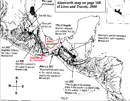
Ainsworth map on page 160 of Lives and Travels, 2000
Map of Ainsworth’s proposed narrow pass as understood by Joe Andersen
Notes
1. Jerry L. Ainsworth, “Identifying the Book of Mormon’s Narrow Pass,” http://www.bmaf.org/node/550.
2. Jerry L. Ainsworth, The Lives and Travels of Mormon and Moroni (n.p.: Peacemakers Publishing, 2000), xx.
3. See Noah Webster, American Dictionary of the English Language (New York: S. Converse, 1828).
4. JVA: Readers should remember also that Mormon describes a “narrow pass” and a “narrow neck,” both of which led from the one and only “line” by the west sea into the land northward:
[Talking about Teancum stopping Morianton before Morianton could get into the Jaredite land northward]: And it came to pass that they did not head them until they had come to [not in] the borders of the land Desolation; and there they did head them, by [not in] . . . (Alma 50:34)
Hagoth . . . built him an exceedingly large ship, on [within] the borders of the land Bountiful by [near but not in] the land Desolation, and launched it forth into the west sea, by [near but not in] the narrow neck which led into the land northward. (Alma 63:5)
Mormon also describes a “narrow passage” and a “narrow pass” that led from the same place on the same “line” into the land southward:
And the Lamanites did give unto us the land northward, yea, even to [not in] the narrow passage which led into the land southward. And we did give unto the Lamanites all the land southward. (Mormon 2:29)
And it came to pass that I did cause my people that they should gather themselves together at the land Desolation [therefore near the west sea], to a city which was in the borders [of land Desolation] , by [but not in] the narrow pass which led into the land southward. (Mormon 3:5)
Because (1) there was a narrow neck and/or narrow pass that led by the west sea into the land northward, (2) there was a narrow passage and/or pass that led into the land southward, (3) the Jaredite land northward was divided from the Nephite land southward by a “small neck of land” (Alma 22:32), (4) Desolation was a part of the land northward and Bountiful was a part of the land southward, and (5) there was a “line” (about a day and a half in length from the east to the west sea) between Desolation and Bountiful, then that “line” must have been located within the “small neck of land.” It then stands to reason that it must also have been where the two narrow passes or passage or neck met, one going northward through Desolation into the land northward and the other going southward through Bountiful into the land southward. How long these passes, passage, and narrow necks were is not discernible from the Book of Mormon. They could have ended shortly after entering or leading into Desolation and Bountiful because each was a part of their respective land northward/southward.
5. The authors and titles of these papers are as follows: Ursulino Rueda Saynez, “De Juchitan Oaxaca—Leyenda, Tradicion y Poesia” and Judith Francis Zeitlin and Robert N. Zeitlin, “Arqueologia y la Epoca Prehspanica en el Sur del Istmo de Tehuantepec,” Department of Anthropology, Brandeis University, Waltham, MA.
6. See Ainsworth, The Lives and Travels of Mormon and Moroni, 262.
7. Over twenty different Maya dialects exist today. Zapoteca is one of those dialects. Those natives who occupy the cities in the Isthmus of Tehuantepec speak Zapoteca.
8. JVA: See Michael D. Coe and Stephen Houston, The Maya, 9th ed. (New York: Thames & Hudson, 2015), 12.
9. See Ainsworth, The Lives and Travels of Mormon and Moroni, 98.
10. See Ainsworth, The Lives and Travels of Mormon and Moroni, 67.