


8. Are Ruin Sites on the Yucatan Peninsula Related to the Book of Mormon?
necessarily represent the views of BMAF or The Church of Jesus Christ of Latter-day Saints.
8. Are Ruin Sites on the Yucatan Peninsula Related to the Book of Mormon?
Copyright © 2015 by Jerry L. Ainsworth
One of the most popular vacation spots on this continent is Cancun, Mexico. Although this vacation paradise began at the northern tip of the Yucatan, a long chain of resorts referred to as the Mexican Riviera now extends down the entire length of the eastern side of this peninsula.
People who vacation in these many hotels and timeshares frequently visit some of the ancient sites that are nearby—such places as Tulum, Chichen Itza, Coba, and the newest site, Ek Balam.
To the intrepid explorer, other interesting sites are available, such as Uxmal, Izamal, Sayil, Oxkintok, and many others on the western side of the Yucatan. And of course numerous small ruin sites consisting of one or two small buildings are available. So many of such small remains are extant that they are frequently incorporated into a golf course or hotel grounds.
Most current Latter-day Saint authors writing about Book of Mormon geography, myself included, consider southern Mexico, northern Guatemala, and Belize the primary lands of the Book of Mormon. Such a view obviously raises questions about the sites located on the Yucatan, especially those on the eastern coast.
Looking at the Map
To have a clear view about geographical references in this response, we need to have a map of Mexico so we can look at the base of the Yucatan Peninsula. As shown in the map below, Highway 186 is found at the base of the peninsula. This highway runs from the west beginning around Laguna de Terminos, proceeds through the city of Escarcega, continues eastward to the eastern side of the peninsula, and ends at the city of Chetumal.
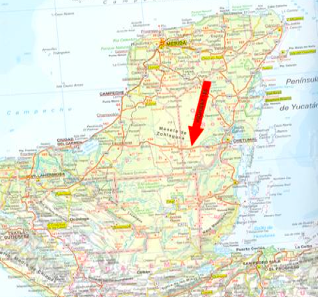
Numerous large, ancient Maya sites appear on either side of this highway. However, when we view the dates of these sites, an interesting phenomenon emerges. With rare exception, most large sites south of this highway date back to the Preclassic time of the Maya (300 BC and earlier). Correspondingly, sites north of this highway date to Classic or Postclassic times (AD 400–AD 1200).
Highway 186 Is the Dividing Line
Three sites in the very northern tip of the Yucatan date back to earlier times, such as the cave of Loltun, a place named Dzibilchaltun, and, most recently, a new site named Ek Balam, but they are the exceptions. A few sites, such as Becan at the bottom of the Yucatan, date back to Preclassic times, but they are located north of Highway 186. However, they are located within walking distance of this highway. In other words, had the highway been built one mile farther north, these older sites would also be south of Highway 186.
The point I am making is that ancient ruin sites that date back hundreds, indeed thousands of years BC, appear all over southern Mexico until travelers reach the base of the Yucatan, close to Highway 186. Once travelers reach the very southern base of the Yucatan Peninsula, an apparent demarcation occurs. Below that southern border (approximately Highway 186), ruin sites date back to the earliest times of habitation and every time period in between.
However, once travelers go north of that southern border (approximately Highway 186), almost every site dates to much later time periods, AD 300 and later, until the time of the arrival of the Spaniards.
Explanation of the Age Difference
This analysis prompts obvious questions: Why? What was it about this line, this southern border of the Yucatan, that caused such disparity in the time frames of the building of these ancient cities?
South of that line are found ancient cities that date back to 1200 BC and even earlier, as well as in every time period after that. Travelers then cross this southern border of the Yucatan (close to Highway 186), and ancient sites do not appear until around AD 300, with those three exceptions at the very northern tip of the Yucatan.
I have read the numerous books on Book of Mormon geography and perused the related maps, but not even one of the authors gives an explanation for this phenomenon. Indeed, they do not even raise the issue.
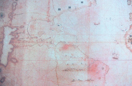
On pages 66–67 of my book, The Lives and Travels of Mormon and Moroni, I offer a possible solution to this conundrum. That is, during most of the Book of Mormon times, the Yucatan Peninsula was an island. In my book, I present two ancient maps that show the Yucatan as an island (see example below).
Since the publishing of that book, I have located an additional ten old maps that also show the ancient Yucatan as an island that is separated from the mainland by seawater or marshland. And that separation takes place very close to Highway 186.
In fact, when it rains hard in this area of Mexico (the base of the Yucatan), the peninsula becomes separated, by water, from the mainland again. The base of the peninsula is so low that six days of rain will simply flood the base of the Yucatan, essentially cutting off the Yucatan from the mainland.
I have driven to the Yucatan many times; and on two occasions, after hard rains, I had to wait three days at Palenque for the water at the base of the Yucatan to subside enough to allow driving across the southern base of the Yucatan.
Book of Mormon Cities in Belize
The Book of Mormon mentions a number of cities that either existed or were built on (or near) the eastern coast of Nephite lands, a coast that most Book of Mormon analysts consider to be in the country of Belize.
Alma 51 names some of these cities, such as Moroni, Morianton, Lehi, Nephihah, Omner, Gid, Mulek, and many others. All of these Book of Mormon cities date back to time periods before the birth of Christ.
When travelers visit the coastal areas of Belize, they can find dozens of ancient ruin sites that date to these early time periods and that are candidates for the cities mentioned by Alma—such ancient sites as Cerros, Santa Rita, Lamanai, Caracol, Altun-Ha, Colha, etc.
Some of these sites, such as Santa Rita, date back to very early habitation, such as 1200 BC. Once travelers leave the area of northern Belize (the location of Santa Rita), an interesting transposition occurs. Travelers then enter the eastern coastal area of the Yucatan Peninsula, which has no ruin sites that date back to time periods before the birth of Christ.
Some sites, such as Tulum, date to AD 400, and then many others date even later, such as AD 600; but none date to the time period Alma talks about.
Separated from the Mainland
I conclude that the Nephites did not occupy the Yucatan Peninsula and did not build cities in the Yucatan proper or on its eastern coast. They built cities, contiguous to each other, all along the eastern coastal area of Belize. However, they stopped at the base of the Yucatan because the Yucatan Peninsula was an island or was separated from the mainland by marshland and therefore was not part of the Nephite lands proper.
This key geographic knowledge makes figuring out Book of Mormon lands exponentially easier. Locating the northern quarter of the land of Zarahemla is now possible, as is locating the border referred to as the “sea north” (Helaman 3:8).
The Nephites had all they could handle in defending their major lands—Zarahemla, Bountiful, etc. Had they also been required to defend cities on the Yucatan, an island during their time, their armies would have been stretched very thin indeed
Contact me with a question or comment: eljefejla@aol.com