


THE TWO CUMORAHS
THE TWO CUMORAHS
(if you wish to print an article, click on printer friendly version at the end of each article)
Materials, concepts, maps or conclusions presented at our forums or appearing on this website or
emailed to BMAF members and guests is the sole responsibility of the contribiuting author(s) and does
not necessarily imply that members of the Board of Directors or members of BMAF agree with all or
any part of the subject matter and is not sponsored in any way by the Church of Jesus Christ of Latter-day Saints
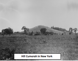 This small hill in Manchester County, New York; where Joseph Smith found metal plates buried and translated them with the gift and power of God, has been the topic of controversy for many years. Though Oliver Cowdery and others began referring to the hill as Cumorah1, Joseph himself referred to the hill as: “a hill of considerable size."2 The name stuck and over the years the tradition developed that the hill was the site of the last Nephite battles.
This paper will examine what the Book of Mormon tells us about the Hill Cumorah. In order to make a reasonable conclusion about its location it will be important to consider distances outlined in the text.
In the past, some theories proposed that Book of Mormon lands included a vast territory covering thousands of miles, from New York in the United States to Chile, in South America. Other theories have confined Book of Mormon lands to the US heartland or extended them to Peru. This paper will illustrate that, upon careful examination, the Book of Mormon itself has much to say about both the location and the size of Book of Mormon Lands.
Mormon informs us that he was raised in the Land Northward which was covered with buildings and people.3 He moved Southward to the capital city of Zarahemla with his father when eleven years old. Prior to leaving the Land Northward, we learn that the prophet Ammaron instructed him to return when he reached the age of twenty four years old to a nearby hill named Shim located in the Land Antum where Ammaron had deposited all the sacred engravings of the Nephites.
With a civilization covering the Land Northward and a vast population as “numerous as the sand of the sea”, there should be sufficient archaeological evidence in the area to show the existence of large numbers of people. The Book of Mormon describes cities with buildings, temples, towers, highways leading from city to city, gardens, market places, silks, gold, silver, kingdoms, armies and governments.4 Any civilization with millions of people, is readily identified by archaeologists as they explore and examine the evidence left behind.
The Land of Desolation and the Land Southward were close enough for commerce and interaction
The Nephites, who occupied the Land of Desolation (part of the Land Northward) during Mormon’s life time, were building with cement due to the forests having been depleted by a previous culture identified in the Book of Mormon as Jaredites.5
The distance between Desolation and the Land Southward cannot be very great because the people, whose main transportation was by foot, knew that there was a Sea North, South, East, and West.
In Southern Mexico and Guatemala, ruins are found made from cement, evidence of an ancient culture with millions of people. And we are able to locate a Narrow Neck of Land; a Sea North, a Sea South, a Sea East and a Sea West. Because of this ample evidence, Mesoamerica has attracted the interest of many LDS scholars who consider it a prime candidate for the Book of Mormon Lands.
Distances defined
How far from the Hill Shim is Zarahemla if Mormon is expected to go back and get the plates when he is twenty-four years of age? Instructions such as these to a young boy ten years of age would suggest that the distance probably was not more than several hundred miles. We gain significant information about the distance from Nephi to Zarahemla in the journeys of Alma 1. Alma’s story begins as a priest in King Noah’s court in the land of Nephi. He was converted by the teachings of the prophet Abinadi.6 Alma fled from King Noah, repented of his sins, and began to teach the words of Abinadi privately among the people. As many as believed went forth to a place called Mormon.7
We can learn the approximate distance between the City of Nephi and the Waters of Mormon from the text. The exact distance is not given but it has to be close enough for contact between Alma and his converts, yet it has to be far enough away so Alma could stay out of the reach of the king. Threatened by the King, Alma’s people left the Waters of Mormon and departed into the wilderness.8 They had time to gather their flocks, grain and possessions before they left. The text measures their movement in terms of days as it follows them on their way back to Zarahemla.9
The first leg of their journey was eight days, and brought them to the Narrow Strip of Wilderness where they hid from Noah’s army. Alma’s group lived several years here and built a city named Helam. They were finally discovered by a lost army of Lamanites who had joined with the wicked priests of Noah. Alma and his church were put in bondage, persecuted, prevented from praying publicly and forced to carry heavy burdens on their backs.
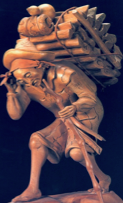 Note: Natives of Guatemala to this day carry extremely heavy burdens on their backs with the help of a strap about 2 inches wide which is placed on the forehead and attached to the load and helps distribute the weight evenly. This cultural practice is reminiscent of Alma’s group wherein their burdens were made light.10
Alma’s prayers were finally answered and a deep sleep came upon the guards allowing Alma’s group to depart into the wilderness. They traveled one day and pitched their tents in a valley they called the Valley of Alma.11
After a short time, the Lord warned Alma that the Lamanites were in hot pursuit so Alma and his group continued their escape. After twelve days they arrived in the land of Zarahemla.12
Approximate distance from the Land of Nephi to the Land of Zarahemla
The Book of Mormon is truly amazing; it gives the distance from the Land of Nephi to the Land of Zarahemla right in the text. Traveling on foot with flocks and possessions, like the Mormon pioneers did, Alma’s group would realistically average about 10 miles per day. The distance from the Waters of Mormon to the Land of Helam was eight days, which would be estimated to be about 65-80 miles. From Helam to the Valley of Alma was one day or 8-10 miles and from the Valley of Alma to Zarahemla was twelve days or 96-120 miles. Adding these together they traveled a total of about 210 miles (8+1+12=21 days x 10 miles = 210 miles). These verses help us understand the relative size of Book of Mormon lands from the City of Nephi through the Narrow Strip of Wilderness to the City of Zarahemla where a large majority of the Book of Mormon story takes place.
Conclusion concerning size of Book of Mormon Lands
The saga of the Book of Mormon mostly takes place in and around the Narrow Strip of Wilderness from 600 B.C. to A.D. 400. It is clear from analyzing the text closely that the overall size of the Book of Mormon Lands is in the hundreds of miles rather than the thousands. Having gained an understanding of the approximate overall size of Book of Mormon lands we now tackle the more difficult question: where are these places located on a modern map?
The geographical importance of the war chapters
Military leaders generally have a command of the lay of the land, which is not only beneficial, but essential in order to be successful, especially in hand to hand combat. The war chapters are packed with valuable information about geography and relationships between Nephite and Lamanite cities. Unfortunately these chapters are often skimmed or skipped by the average reader, a big mistake if one is looking for distances and locations. Mormon, the leader of the Nephite army, provides helpful details as we try to locate the Nephite homeland. He tells us that his armies have retreated and are now fighting near where the Nephite records were first deposited by Ammaron in the Land Northward. Mormon further explains that they are fighting for their homes, wives, and children, so they must be fighting near their homeland.13
The Nephites lose ground
Finally, in A.D. 350, a treaty was signed between the Nephites and the Lamanites14 which gave all of the land Southward to the Lamanites. This would have included the Land of Zarahemla which was in the Land Southward. How far would they likely travel away from their home land while fighting for it? The Nephite homelands, according to the text, are located around or near the Narrow Neck of Land. It is not realistic to think that they would travel hundreds or even thousands of miles to unfamiliar territory so they could wage war over land located back where they came from. The fighting remained localized because in A.D. 350 since they were still fighting near the Narrow Neck of Land which separated the Land Northward from the Land Southward.
Hill Shim
Where is Hill Shim in relationship to the Narrow Neck of Land and the Narrow Passage? In the process of retreating Northward, Mormon retrieved the records from the Hill Shim while still fighting the Lamanites near the Narrow Neck of Land. The names Land Northward and Land of Desolation are interchangeable, so they are now in the Land of Desolation. Desolation is North of the Narrow Strip of Wilderness which divides the Land Southward from the Land Northward. Hill Shim is North of the Land of Zarahemla and it is also North of the Narrow Neck.
Ten years without war
Mormon says that ten years had passed away since the treaty when he received a letter from the king of the Lamanites telling him that they were again coming to battle. Therefore, in A.D. 360, they were still fighting near the Narrow Neck of Land and in the Land of Desolation, where their homes and families were.
By A.D. 363 the Nephites had become so wicked that Mormon refused to lead them. In the fourth chapter of Mormon things look bleak for the Nephites as they had to fight without Mormon’s assistance. The Nephites took refuge in Teancum, a Nephite city, located by the seashore (gulf of Mexico near Veracruz) in the Land of Desolation.15
Hill Shim is close to Teancum
Considering the archaeological evidence and the physical description found in the text, we must consider the seashore in Southern Mexico as a serious possibility for the location of these final battles. Since they are still in the Land of Desolation, but are now in the City of Teancum, how far are they from Hill Shim? It must be close because Mormon is worried about the records falling into the hands of the Lamanites. Mormon tells us that the Nephites and Lamanites traded possession of the City Desolation and the City Teancum, and that the battles were very sore. The Nephites fled to Boaz and other villages in A.D. 375 and Mormon, concerned for the safety of the records, went to Hill Shim and removed them.16
Considering the distance between Hill Shim and the Narrow Neck
Since Mormon is concerned about the records when the Nephites retreated into the Land Northward, and since they were hidden close enough for him to go back to get them after he moved to Zarahemla, it would appear Hill Shim is not too far from the Narrow Neck of Land. The Lamanites were relentless and continued to fight for possession of the Land of Desolation occupied by the Nephites. By A.D. 375 the Nephites had lost all of the Land Southward and the Land Northward is in danger of being lost as well.
Moving the records from Hill Shim
Mormon mentions that his record is small in comparison to the many records Ammaron hid in the hill.17 This begs the question, how many records are “all of the records” and how far is Mormon able to move a room full of records with the pressures of warfare ever present?
In chapter five, Mormon expressed sorrow over the wickedness of his people and decided to write a letter to the king of the Lamanites. In the letter he asks for some time to gather his people to Cumorah in preparation for what becomes the final show down.
The final battle
The gathering to Cumorah took approximately four years. It was there, in this Land of Cumorah, at the hill called Cumorah, that Mormon buried all the records except his own writings which he gave to his son Moroni.18 It is those plates that were given to Moroni by Mormon that Joseph Smith translated into The Book of Mormon.
Determining approximate distances for Book of Mormon locations
The Book of Mormon narrative indicates a rather short distance between Cumorah and the Narrow Neck of Land. Mormon’s epistle to the Lamanite king requesting permission to gather and fight at Cumorah, suggests that they are in close proximity to the lands of the Lamanites because both are aware of the hill and Mormon can still correspond with the Lamanite king. The text does not allow for hundreds of miles between them.
Some survivors of the final battle
After the horrific final battle, some Nephite warriors survived and tried to escape into the Land Southward, where they were hunted down and killed.19 It hardly sounds feasible that they would travel all the way from where New York is today to hide in the Land Southward. Those who try to place Book of Mormon geography in the United States to avoid these extreme distances then have to ask, “Where is the archaeological evidence to support that conclusion”? There is no evidence to suggest a culture of millions of people, during the Book of Mormon times, lived anywhere in the US heartland.
The Book of Ether
We can obtain some additional Book of Mormon geographical information when we go to the Book of Ether. Moroni informs us that King Omer was living in the Land Northward and in fleeing the opposing army of Akish, traveled many days, passing the Hill Shim and the place where the Nephites were destroyed (the Hill Cumorah) and settled by the seashore. This suggests, as do many other parts of the text, that the Hill Shim and the Hill Cumorah are not too far apart.20
Where was Omer living?
Omer did not travel far from the land of his inheritance when he fled for his life because others knew where he was and went over to join him. To travel several thousand miles each direction does not seem reasonable and is not consistent with the text. Eventually Akish was overthrown and Omer was again restored to his kingdom.21
Many generations pass away but the Jaredites stay in their land of inheritance
From Omer to Lib, many years had passed away, but we find no mention of a migration of the people from the area. In fact, the text says that the kingdom was passed from one to another, and that they remained in the same area, building a city near the Narrow Neck of Land.22 The Land Southward was not far away; as they preserved the area to hunt animals for food to feed their families. Moroni tells us of the massive population in the North with inhabitants covering the land.23
The Final battles among the Jaredites
The final battles were primarily civil wars. Each side spent four years recruiting people on their side hoping to gain sufficient strength to become successful. The final battles of the Jaredites were fought around the Hill Ramah/Cumorah, the same hill where centuries later the Nephites would have their final battle. Massive populations of both Nephite and Jaredite people inhabited this same land covering hundreds of years. There is only one place in the Americas where evidence of civilizations of this size existed during Book of Mormon times and that is Mesoamerica.
The Prophet Ether
The last Jaredite prophet, named Ether, hid his records in a manner that the people of Limhi found them many years later. presenting impressive evidence that the entire Jaredite story took place in a localized area. The Jaredites always go through the Narrow Neck of Land to get to the Land Southward. This means that the Hill Cumorah would not be thousands of miles from the Narrow Neck of Land.24 As with the Nephite narrative there is no mention of cold weather as they gather in the area of Ramah/Cumorah. This shows an impressive correlation and consistency in the text of the Book of Mormon between the stories of the Nephites and the Jaredites.
The Gulf Coast
The Gulf Coast of Mexico has been called Mexico’s golden lane. A rich agricultural land that produces bananas, pineapple, sugar cane, tobacco, rice, and all types of fruits and vegetables; the Gulf Coast is the same area where the great oil reserves of Mexico are located today. The area was also home to Mexico’s first civilization that archaeologists have come to call the Olmecs. Traditional historical accounts suggest that the first settlers to Mexico came from the tower of Babel when all other languages were confounded except their own. Students who have studied both the ancient civilizations of the Americas and the Book of Mormon notice a striking relationship between the Olmecs of the Gulf Coast of Mexico and the Jaredites in the Book of Mormon.
Investigation of the Olmec Culture
In 1941, Matthew Stirling and two Mexican archaeologists presented a monumental report at an archaeological convention in Mexico City. They proposed in their report that the Mayas were not the oldest civilization of Mesoamerica but rather that the ancient people referred to as the Olmecs held that honor. Several years elapsed before science confirmed their report. Stirling conducted field work at the Olmec site of Tres Zapotes from 1938 to 1943. With the advent of Carbon 14 dating and the dating of certain glyphs, archaeologists have confirmed that the Olmecs are indeed the mother civilization of Mesoamerica. The Olmec sites of San Lorenzo and LaVenta were excavated and investigated in the 1960s, the former by a Yale archaeologist, Michael Coe. He labeled the downfall of the Olmecs at both San Lorenzo and La Venta as a violent downfall because many of the stone monuments were intentionally mutilated. The Olmecs are immediately recognizable by the giant stone heads.
Interpretative Analysis
The traditional history of Mexico, the archaeological data, and the Book of Mormon all present parallel records of a group of settlers who left the Tower of Babel and settled in a northern portion of Mesoamerica. All three witnesses, the Book of Mormon, traditional history, and archaeological evidence record a high culture from about 1200 to 400 BC. In addition, all three witnesses depict an internal destruction of the people between 400 BC and 100 BC. These three witnesses, along with other historical and geographical information,suggest a parallel between the Jaredites in the Book of Mormon and the Olmecs along the Gulf of Mexico.
*Note: The Olmec people, who lived in the Gulf of Mexico area, align quite closely both historically and archaeologically with the approximate dating of the Jaredite nation (For details see appendix #1).
Limhi’s forty-three men find the Jaredite ruins
These observations are further solidified by reading the account of the people of Limhi, who lived in the Land of Nephi and were in bondage to the Lamanites. We are told in Alma 22:28 that the land of their first inheritance is west of the land of Nephi. (The land of their first inheritance was the place where Lehi and family landed upon their arrival in their promised land). Limhi and his people grew tired of being in bondage to the Lamanites, so Limhi sent a group of forty-three men to find the Land of Zarahemla where his grandfather had left years earlier.25 These forty-three men went from the Land of Nephi looking for Zarahemla and instead found the Land of Desolation where the Jaredites had been destroyed. From the account of this Limhi expedition we previously examined in Mosiah, we learn that those traveling from Nephi to Zarahemla knew approximate distances, though they did not always know exact directions.
Understanding the Geography in the Book of Mormon
One of the most complete descriptions of Book of Mormon geography is found in Alma 22:27-32 where we learn the following details:
| The Land of the Nephites' First Inheritance is west of the Land of Nephi, and in later times is occupied by the Lamanites (Alma 22:28) | |
| The Land of Nephi borders on the Land of Zarahemla | |
| The Land of Zarahemla borders on the Land of Bountiful | |
| The Land of Bountiful borders on the Narrow Neck of Land, which borders on the Land of Desolation | |
| The land described has an East Sea, North Sea, South Sea, and West Sea | |
| There are Lamanites on the Eastern and Western seashores | |
| The people of Limhi thought they had found Zarahemla when they were in the Land of Desolation and found the twenty-four gold plates. They therefore felt they had not traveled much further than the expected distance from Nephi to Zarahemla |
Conclusion derived from Alma 22
If the Land of Nephi borders on Zarahemla, and Zarahemla borders on Bountiful and Bountiful borders on Desolation, but is divided from Desolation by the Narrow Neck of Land, how big is the area described? With Lamanites on the Eastern and Western shores and the Nephites nearly surrounded except on the North, we have to assume a small enough area to have the Nephites aware of that type of topography. The above description would not describe North and South America but would have to be much more localized. If the area described was in New York State, we would expect to find archaeological evidence to support this conclusion, such as is found in Mexico and Guatemala.
They traveled in terms of days not years
We have determined from the text in Mosiah 23 and 24 that the distance from Nephi to Zarahemla is approximately twenty one days’ journey, eight days to Helam, one day to the valley of Alma, and twelve days to Zarahemla. This distance is supported by the account of Limhi’s group who,with the help of Ammon, escaped from their Lamanite captors. In Mosiah 22 we are told that the Nephites in the land of Nephi left the Lamanites drunk and departed into the wilderness with Ammon and Gideon leading the way. They traveled in the wilderness many days with wives, children, flocks, herds, gold and provisions. Mosiah 22 is consistent, these accounts never mention years although years are mentioned in other places in the Book of Mormon. So we learn that the distance from Nephi to Zarahemla is twenty-one days if you are fleeing, but not more than forty days if you are lost in the wilderness. it is reasonable to assume that if the forty-three men of Limhi knew approximately how far it was from Nephi to Zarahemla, and the text would indicate that they did, how far would they have walked before realizing that they were lost? Would Limhi’s group have travelled thousands of miles knowing that Zarahemla would be only 250 to 400 miles away? The account says they traveled many days, not years. We conclude that when the forty-three men of Limhi walked to Cumorah in the Land of Desolation it had to be a reasonable distance from the Land of Nephi and reasonable is not thousands of miles.
Coriantumr lives nine moons with the people of Zarahemla
One more account supporting a smaller geography deals with the Jaredite survivor Coriantumr. It is obvious that Zarahemla cannot be very far from Ramah/Cumorah since the Jaredites fought their final battles at Ramah and afterwards the people of Zarahemla discovered a wounded Coriantumr who stayed with them for nine moons. It isn’t likely or reasonable and may not even be possible for a wounded Coriantumr to travel thousands of miles to meet up with the people of Zarahemla and it is not reasonable for them to travel Northward thousands of miles to find him either.26
Strong parallels between the Jaredites and the Olmecs
The writings of the fifteenth century historian Don Fernando De Alva Ixtlilxochitl regarding the Olmecs indicates some very strong parallels with the Jaredite record in the Book of Mormon. The archaeological evidence reveals that the Olmec nation was destroyed near the Gulf of Mexico, which establishes a strong connection between the Olmecs and the Jaredites. Since the Nephites were destroyed at the same hill as the Jaredites, then the Nephites would also have been destroyed near the Gulf of Mexico.
Most credible LDS scholars of the Book of Mormon propose that the Jaredites, the Nephites, and the Mulekites arrived and settled in Central America. Archaeological and historical evidence in Central America parallels the text and events that are described in the Book of Mormon. Evidence of a population to match that described in the Book of Mormon is found only in Mesoamerica. If these three groups of people all landed in their “Promised Land,” it is not reasonable that they would then migrate great distances to the North or South far away from their Promised Land. Without question, there were some curious or dissatisfied people who migrated to other parts of North and South America, but the text is firm in its assertion that the main body of people remained localized around the Narrow Neck of Land. If Mesoamerica is where they landed, and that is where the evidence is found, then the Book of Mormon text certainly appears to support the limited view of Book of Mormon geography.
The accounts given in the text of the Book of Mormon, as mentioned above, suggest that there is a Cumorah where Mormon buried “all of the records” save the few which he gave to his son Moroni. This Cumorah was in the Land of Desolation and near the Narrow Neck of Land. The Book of Mormon allows for the possibility of a different Cumorah, “Moroni Cumorah,” where Moroni buried records given him by his father. Moroni was obviously shown or told where the records needed to be buried so that the Prophet Joseph Smith could find them when the time was right.
Hill Vigia the number one candidate for Mormon’s hill Cumorah
The proposed site for the Nephite Hill Cumorah is Hill Vigia. The following are reasons why Vigia is considered by many LDS scholars as the prime candidate for the Nephite and Jaredite hill where their final battles took place. The Book of Mormon text and modern research teach us the following:
| Cumorah is near an eastern seacoast. (The Gulf of Mexico constitutes an eastern seacoast 30-40 miles from the Hill Vigia) | |
| Cumorah is near a Narrow Neck of Land. (Hill Vigia is about 60 miles from the top of the pass and runs through the Isthmus of Tehuantepec) | |
| Cumorah is situated so as to overlook a coastal plane. (Hill Vigia meets this requirement) | |
| Cumorah is one day’s journey by foot from a large body of water called Ripliancum in the Book of Mormon. (The Papaloapan Water Basin that empties into the Gulf of Mexico is about 18 miles from the base of the Hill Vigia) | |
| Cumorah is near a land with many waters and fountains. (Hill Vigia is located in a land of beautiful lakes and picturesque rivers and underground water springs.) | |
| Cumorah is located in an area where an abundance of water is available to provide food for men, women, and children and a military advantage. (The Tuxtla Mountains, where Hill Vigia is located, meets that requirement. The land around Hill Vigia is very fertile, suitable for growing food for large numbers of people.) | |
| Cumorah is on a secluded route between coast and mountains. (Where the Nephites, fleeing to the south countries, could escape without being captured by the Lamanites. A secluded route between the coast and the Tuxtla Mountains meets this requirement.) | |
| Cumorah must be a significant landmark. (Because two nations perished on this hill and because sacred records were hidden there. Today, a radio relay is stationed on the top of Hill Vigia and it is called Lookout Mountain.) | |
| Cumorah must be a significant landmark. (Because two nations perished on this hill and because sacred records were hidden there. Today, a radio relay is stationed on the top of Hill Vigia and it is called Lookout Mountain.) |
| Cumorah was situated in a warm climate. (There is no reference to snow or cold in the Book of Mormon. The Tuxtla Mountains area is known as the Hawaii of Mexico.) | |
| Cumorah must be free standing. (This is so people could camp around it.) It must also be situated in such a manner that it could serve as a protection for the women and children. (Hill Vigia meets that requirement) | |
| Cumorah was in an area subject to volcanoes and earthquakes. (Mesoamerica is a land of volcanic activity and earthquake eruptions.) | |
| Cumorah was occupied by Jaredites as well as Nephites. Evidence from pre-classic as well as classic time periods (2200 BC to AD 400) is found in this area. |
Hill Shim
An interesting fact sometimes overlooked by the traditional view is that the plates were originally buried in the hill Shim which was also in the Land Northward . Some impressive supportive linguistic evidence is found with the name Shim. Shim in the Maya language means corn. There is a hill in the Tuxtla Mountains not far from Hill Vigia named Cintepec. The last part of the word Cintepec, “tepec,” means hill or mountain in the Nahuatl (Aztec) language. The front part of the word, “Cin,” means corn. Hence, the word Cintepec means corn hill. The hill, Cintepec, is located east of Lake Catemaco in the Tuxtla Mountain Range in the State of Veracruz, Mexico. This makes Cintepec the leading candidate for the location of the Hill Shim where Ammaron hid the plates. As an interesting sideline, Cintepec is the hill where the stone was quarried to construct the large Olmec stone heads discovered along the Gulf of Mexico.
Moroni hides the plates where they can be found by Joseph Smith
The final battle took place in A.D. 385 but Moroni didn’t complete his book until A.D. 421. So Moroni had thirty-six years to wander and write the book of Moroni and abridge the book of Ether. During thirty-six years of wandering, he could easily travel the many miles to New York State, where he buried the records in a manner that Joseph Smith could find them. What is certain is that Moroni did at some time, either in mortality or as a resurrected being, hide his record in that hill near the Smith farm in New York.
The New York Cumorah is sacred to all Latter-day Saints
The problem for those who propose that Nephite heartlands are in the Central and Eastern United States is virtually no evidence exists of true civilizations as described in the Book of Mormon living in the area during the time period of the Book of Mormon. Nor was a written language in use around the US heartland area from 600 BC to AD 400. The importance or the sacredness of the New York Hill Cumorah is not lessened in any way by such information. In the wisdom of the Lord, the only place in the world where the gospel could be restored and where the gold plates could have been translated and published in the early 1800’s was the free land of the United States of America.
The primary issue at stake for Latter-day Saints is how to correlate the traditional concept that the last battles were fought in New York with the newer concept that they were fought in Mexico and if so, how did the plates get from Veracruz, Mexico to New York. This matter is easily explained by a close look at Mormon 1:1-4; 8:2-6. Certainly it is more logical for Moroni to wander for a number of years with a handful of plates than for the entire Nephite nation to travel with their women and children, and “all” the records, to an unknown land, a land mixed with heat, cold, snow and ice. The trip from Mexico (Narrow Neck of Land area) to New York is nearly 4,000 miles.
The question concerning the traditional views of Book of Mormon geography has been difficult to deal with only because we become comfortable with our traditions and are not as likely to investigate the facts thoroughly. Of course, not all traditional views are incorrect but the facts will eventually come to be known and accepted as the incorrect traditional ideas give way to more logical and truthful ones. As Joseph Smith once put it, “facts are stubborn things”.27
Similarities Between Olmec and Jaredite Civilizations
According to the written history of the 16th century historian, Fernando de Alva Ixtlilxochitl the Tultecas (now known as Olmecs) were the mother culture of the Americas. The following is an impressive comparison between what Ixtlilxochitl tells us about his ancestors and what is said in the Book of Mormon about the Jaredites. Ixtlilxochitl writes that they (his ancestors, the Tultecas) built a Zaucalli very high and strong, which means “The Very High Tower,” to protect themselves against a second destruction of the world. As time elapsed, their language became confounded, such that they did not understand one another; and they were scattered to all parts of the earth. The Tultecas, consisting of seven men and their wives were able to understand each other; and they came to this land, having first crossed many lands and waters, living in caves and passing through great trials and tribulations. Upon their arrival here, they discovered that it was a very good and fertile land.28
| 1. Mother Culture | 1. Mother Culture | ||
| 2. Preclassic – 2500 BC – 1500 BC Classic – 600 BC Late Olmec/Maya | 2. Pre-classic2500 BC – 300 BC Classic 600 BC – 300 BC | ||
| 3. Died out due to Civil War | 3. Died out due to Civil War | ||
| 4. Great internal destruction 400 BC | 4. Great internal destruction at 400 BC due to wickedness and sins and lack of repentance. (Ether 13:21) | ||
| 5. They came from a Great Tower | 5. They came from the Tower of Babel when languages were confounded | ||
| 6. Reached their high classical period at 1500 BC – 600 BC (massive civilization) |
6. They reached their high or classical period at 1500 BC – 600 BC |
||
| 7. Spanish writers called them (Quinametzin), giants |
7. Jaredites were large people. Breast plates were found by Limhi’s men that were too large for the Nephites |
||
| 8. Historians recorded a great destruction | 8. Ether records a great destruction before the final war. (Ether 11:7) | ||
_References:_____________________________________________________________________________
1. (Joseph Smith and the Restoration, by Ivan J. Barrett, p. 98-99)
2. (History of the Church, vol. 1, p. 15)
3. (Mormon 1:2-8)
4. (2 Nephi 5:15-17)
5. (Helaman 3: 3-11)
6. (Mosiah 17:2-3)
7. (Mosiah 18:4)
8. (Mosiah 18:34-35)
9. (Mosiah 23:1-4)
10. (Mosiah 24:14)
11. (Mosiah 24:16-20)
12. (Mosiah 24:21-25)
13. (Mormon 2:17-23)
14. (Mormon 2:28, 29)
15. (Mormon 4:1-3)
16. (Mormon 4:23)
17. (Mormon 6:6)
18. (Mormon 6:6)
19. (Mormon 8:2)
20. (Ether 9:2-3)
21. (Ether 9:8-13)
22. (Ether 9; 10:19-21)
23. (Ether 9:31 & 10:19-21)
24. (Ether 15:11-33)
25. (Mosiah 21:25-27)
26. (Ether 15:21)
27. (Times & Seasons, vol. 3, p. 921-22)
28. (Ixtlilxochitl: 6-8)