


RIVER SIDON PROBABLY WAS NOT THE GRIJALVA RIVER
River Sidon Was Probably Not The Grijalva
by Joe V. Andersen
January 2011 joeandersen38@gmail.com
I say that the Grijalva River was probably not the river Sidon of the Book of Mormon because I am not quite as sure on this topic as I am of other locations that I have written about, eg. Desolation, “Lib”, Bountiful, Kaminaljuyu etc. (all of the articles about these locations can be found at BMAF.org). I have studied the article by Joseph L. Allen, et al, 2009 located at BMAF.org, entitled The Waters of Sidon": The Grijalva or the Usumacinta?, hereafter referred to as Allens’ Article. I agree that they have identified some important qualifiers for the placement of Zarahemla on the Grijalva River near the site of Santa Rosa. These qualifiers include; the Grijalva flowing northerly past Santa Rosa; Santa Rosa being located on the west side of the river Grijalva; Manti being located about 50 miles from Santa Rosa; and Manti (La Libertad) being located on the northern edge of the narrow strip of wilderness. However, there are also important qualifiers missing and some very important erroneous assumptions and conclusions made in the article and in Allens’ Book, Exploring the Lands of the Book of Mormon, 2010 2nd edition, hereafter designated as Exploring.
I have also studied Jerry Ainsworth’s interesting response, also cited at BMAF.org, entitled RESPONSE TO ALLENS’ ARTICLE ON RIVER SIDON January 2010, hereafter cited as Ainsworth’s Response. All notations, comments, and emphasis in red are mine.
In the introductory paragraph of Allens’ Article it states:
We are three of the proponents whose analyses lead to the conclusion that the Grijalva River, which runs through the central depression of Chiapas, Mexico, is the river Sidon of the Book of Mormon. We invite all Book of Mormon readers to evaluate this article’s evidence and either accept it at face value or prepare valid rebuttals (emphasis is mine).
As interesting and informative as their article is I cannot accept it at face value because:
2. Some of the archeological and historical data from Mesoamerica are not current and are inaccurate.
3. The proposed placement of the cities of Melek and Ammonihah outside the borders of Zarahemla (Santa Rosa) does not conform to the Book of Mormon.
4. The distance between Santa Rosa (Zarahemla) and Kaminaljuyu (Nephi) is too great.
5. If city Bountiful was located at Dzibanche, Yucatan, then Zarahemla could not have been on the Grijalva because Santa Rosa on the Grijalva would not have been located in the “center of our land” as required by the Book of Mormon.
The Allens further state in their article:
…our observations are that many scholars use subjective analyses, illogical reasoning, or a lack of adequate criteria in choosing between the Grijalva or the Usumacinta as the river Sidon. From our perspective, the task of deciding whether the Grijalva or the Usumacinta is Sidon should be a relatively simple one if we examine carefully what the Book of Mormon itself says and use that information in conjunction with archaeological and historical data from Mesoamerica. In the process, we must be totally objective in examining the data and drawing valid conclusions. We conclude unequivocally that the Grijalva River is the river Sidon…
I submit that the Allens have not been “totally objective“ and they have drawn many “invalid conclusions” from the historical and archaeological evidence from Mesoamerica. I further submit that all the archeological evidence is not in yet and it is much too soon to state unequivocally that the Usumacinta is not the river Sidon or that the Grijalva is the river Sidon.
EIGHT OF THE MOST QUESTIONABLE ASSUMPTIONS AND CONCLUSIONS ARE THE FOLLOWING:
1. At pages 595-96 of Exploring it assumes “…this area [the vast Maya heartland including Peten and Belize] was heavily populated beginning at 150 BC and continuing to the conquest of Mexico in the sixteenth century. This area is literally dotted with ruins of ancient buildings, including Tikal, El Mirador [in Peten], Bonampak [west of Usumacinta River], Uaxactun [Peten], Rio Negro, [on Usumacinta River] Lamanai, and Altun Ha (both on the Belize coast).”
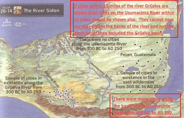
2. On the map at page 653 of Exploring it mistakenly states; “there were no cities on the Usumacinta River from 300 BC to AD 250.”
3. On the map at page 568 of Exploring it shows that the “east wilderness of Zarahemla” included an area from west of the river Usumacinta (Bonampac) to all of Belize and then it also included Dzibanche in the Yucatan and all of the Peten from north of the narrow strip of wilderness.
4. The Jaredites’ “land southward for a wilderness to get game” and the Nephites’ “wilderness which was called Hermounts” are the same location.
5. The Uxpanapa-Chimalapa wilderness (100 miles from Santa Rosa, (Zarahemla) was Hermounts.
6. Melek was located 90 miles from Zarahemla, across a mountainous wilderness, and near the west sea (near Tonala).
7. Santa Rosa on the Grijalva was located in the center of the Nephite Lands.
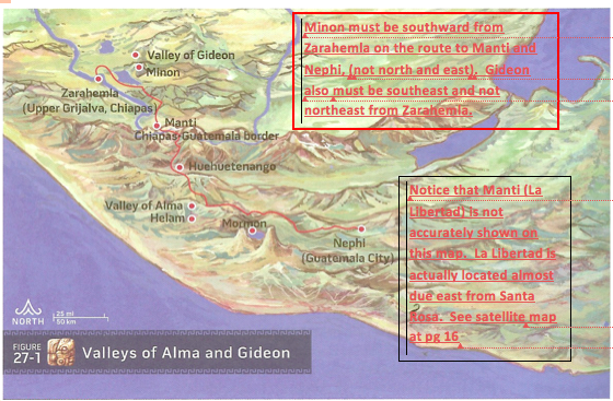
8. Minon was located north and east of Zarahemla instead of mostly south.
The huge Maya population in Peten did not begin at 150 BC. It did not continue in cities like Tikal, El Mirador, Uaxactun etc. until the conquest of Mexico in the sixteenth century. There were many Pre-classic cities along the Usumacinta River.
At pages 595-596 of Exploring, the Allens misstate the beginning population date of the Maya in the Peten and Belize areas stating that … ”beginning at 150 BC and continuing to the conquest of Mexico in the sixteenth century…” In fact, the Maya began significantly populating those areas about 1500 BC and the occupation reached its Zenith about 250 BC. Then there was a hiatus about AD 150 or so before their final collapse about AD 800 to 900. Lamanai, in Belize, is an exception to this statement because it was continuously occupied from 1500 BC to about AD 1500, (see Wikipedia).
On the following map (also located at page 653 of Exploring) is the critical, outdated and erroneous statement that “there were no cities along the Usumacinta River from 300 BC to AD 250”. The wording is in bold type and the map clearly shows a complete absence of any sites along the entire Usumacinta river. I submit that this is a false statement and completely lacking in “adequate criteria” and fails to consider current archeological information.
The Nephite/Lamanite/Mulekite people did not predate or include all of the Maya. The enormous Maya culture pre-existed the Nephites by many hundreds of years, contrary to what the Allens state.
In order to help understand the extent of the Maya culture in the Peten area (including along the Usumacinta River) I quote from /Authenticmaya.com at mayaculture.htm. Nov.2010:
Most archaeologists agree that ancient Guatemala was the cultural and commerce center of the Americas, and that the Mayan civilization, is the jewel of all ancient American cultures, and one of the greatest civilizations the world has ever known.
The Mayan Culture developed between 3000 and 2000 BC. Pollen samples [have] shown the establishments of agriculture in Guatemala by 4000 BC, and around 2500 BC initiated the building of small cities with some permanent architecture all over the country (Pre-Classic). According to Houston the Cho'lan language, the precursor to the Maya, originated in the Guatemalan Highlands, ca 3000 BC. In the tropical lowlands of El Mirador Basin, in the Petén Lowlands,of Northern Guatemala,…[there are] huge cities like Mirador, Nakbé, San Bartolo, Tintal and others, although there were some early cities in the Guatemala Highlands (Naranjo, Kaminal Juyú, Nebaj, Guaytán, El Portón), and in the Pacific Low Lands (Tak’alik Abaj, Chocolá), [they did] not reach the size of those in Petén where they built at least 27 big cities and countless smaller ones at its peak around 250 BC.
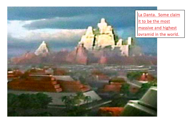
El Mirador, the Cradle of the Maya Civilization, where the cities were not only numerous, but very sophisticated, and developed, with architectonic structures from 1400 BC. Indeed the two biggest cities of the Maya Civilization (Mirador and Tintal) are there, with the same religious beliefs, astronomical knowledge, mathematics and writing knowledge [of] those in the Classic period.
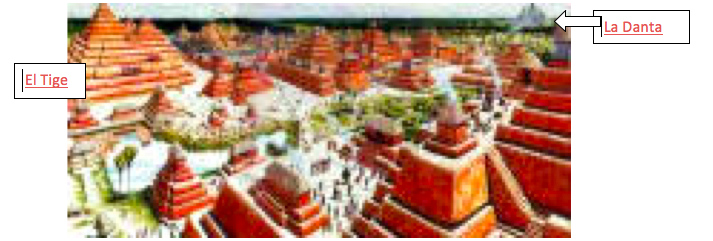
EL Mirador in 300 BC, El Tigre [pyramid] in first plane, La Danta [pyramid] in the horizon. View from Los Monos [pyramid].
There [were] 26 cities, [surrounding El Mirador] some bigger than Tikal, the Jewel of the Classic period, all connected by huge Sacbeob (Plural for highways ), or Sacbé (Singular), meaning "White road", up to 40 Km. long (Tintal-El Mirador, the largest in Mesoamerica) and up to 44 m. wide and 2 to 6 m. above the ground, paved with stucco.
El Mirador provides the richest undisturbed laboratory on the origins of the Maya civilization and its earliest kingdoms, culture, history and environment, and the reasons of the collapse [about AD 150] of a civilization of nearly one million people [in the Mirador basin].
We don't know if the early Maya went to war mainly to acquire territory, take booty, control conquered groups for labor, take captives for sacrifice in sanctification rituals, or a combination of these.
A Late Classic occupation in the seventh and eighth century AD. occurred in the Mirador Basin, although never approaching the levels seen during the Late Pre-classic heyday of the site [250 BC..
Clearly, the massive Pre-classic Mayan culture extended from the Yucatan on the north to the highlands of Guatemala and perhaps the Pacific Ocean on the south and from Belize on the east to the interior of Mexico on the west to at least Palenque. As pointed out in Ainsworth’s Response there were many Pre-classic cities along the Usumacinta River:
Since that time [about 1978] however, many sites have been discovered in the Petén area and the Usumacinta basin – and many are yet to be discovered. The Allen article mentions but a few of these ancient sites, says they were sparsely occupied, or did not exist during the days of Alma. When I first began attending Maya conferences, this was the view expressed. However, more recently, reports by archaeologists state just the opposite. We now know there were thousands of sites in this geographical area, and many of them date back to 1000 BC, 600 BC, and many time periods in between. In the conferences I report on at the end of this response, I give the comments of thirteen leading archaeologists, from the 2007 Maya conferences. Literally all of them support what I just wrote. I invite you to read their comments at the end of this response. There were clearly many large and sophisticated sites in the Usumacinta basin during the time period mentioned by the Allens’ article…
Richard Hansen (Idaho State University)
When researchers dug down to bedrock at Tikal, Uaxactún, Palenque, and many other Maya sites along the Usumacinta Basin, they discovered much earlier occupation, (before 1200 BC), and those older sites were occupied by very sophisticated people, not hunter/gatherer types. These earlier sites were very complex and sophisticated, and extended from LaVenta to the Pacific, to the highlands of Guatemala, as well as the Mirador basin.
In 350 AD, there were significant changes in many of the sites in the Usumacinta basin
Not only were there many Pre-classic locations along the lower Usumacinta but there were many more locations in the middle Usumacinta area such as Chama and Nueve Cerros. Along major tributaries like the Passion River, there were areas of Pre-classic occupation. Quoting from Ancient Maya:
…archaeologist Arthur Demarest stumbled onto a 2.5 square kilometer plaza in the ancient city of Cancuen. Demarest suspects that the city had substantial control of raw resources, which allowed it to be one of the most powerful forces in the region from 400 BC to AD 800. Cancuen's wealth is apparent from one of its three story, 270,000 sq. ft, 170 room palaces that rivals the largest temple of Tikal.
Seibal, also located on the Passion River,(near its confluence with the Usumacinta River) is another example of a Pre-classic site, once thought of as only Classic (notice that this site almost precisely parallels the occupation at Santa Rosa). Quoting from Wikipedia:
Seibal, known as El Ceibal in Spanish, is a Classic Period archaeological site of the Maya civilization located in the northern Petén Department of Guatemala. It was the largest city in the Pasión River region. The site was occupied from the Preclassic Period through to the Terminal Classic, with a significant hiatus. The principal phase of occupation dates to the Late Preclassic (400 BC – AD 200), followed by a decline in the Early Classic (AD 200–600).
Along the Salama River, a major tributary of the upper Usumacinta area with its headwaters located near Coban, there have been over 40 Pre-classic sites, including El Porton, identified by the archeological team of David Sedat and Robert Sharer of the University of Pennsylvania cited at University of California Archaeological Research Facility Contribution 16: 23-35, (1972).
However, just because the Allens made erroneous assumptions and conclusions that (1) the Maya in the Peten area did not begin to populate the area until about 150 BC; (2) that there were “no cities along the Usumacinta from 300 BC to AD 250” and (3) that they were sparsely populated during Book of Mormon time periods, does not preclude the Grijalva River from being the Sidon. But it does mean that the River Usumacinta could have been the Sidon and, therefore, we must not accept Allens’ further erroneous conclusion that “unequivocally the Grijalva River is the river Sidon.” It also demonstrates the failure of being “totally objective in examining the data and drawing valid conclusions.”
ASSUMPTION NO. (3)
Peten and Belize could not have been the East wilderness of Zarahemla because there were too many Mayan people living there before, during and after the Book of Mormon time period.
As shown above, the huge Mayan culture and population clearly pre-dated the Nephite/Lamanite/Mulekite people by many hundreds of years before the Nephites even arrived in Mesoamerica. The Book of Mormon never allows for the Nephites or Lamanites ever conquering or converting the million plus Maya living in the Peten. Moroni could not have conquered all those Maya and forced them south of the narrow strip of mountainous wilderness as required by the Book of Mormon. Therefore, the Peten could never have been included in the “east wilderness of Zarahemla,” The Nephites clearly did control a relatively small area on the east sea, north of the narrow strip of wilderness. For a detailed analysis of many reasons and scriptures in support of the above, see my article at BMAF.org entitled Why City Bountiful was not Located in the Yucatan, Peten or northern Belize.
I submit that there is no possible way the people of Zarahemla could have ever located a new city Bountiful, 315 air miles northeast from the west side of the Grijalva at Santa Rosa. The almost impossible route between Santa Rosa and Dzibanche would have included crossing the Grijalva River; the Lacadon Mountains; the jungle between Grijalva to the Usumacinta; the huge Usumacinta River; the huge Peten Jungle; and then passing through the area of a million or more potentially hostile Maya.
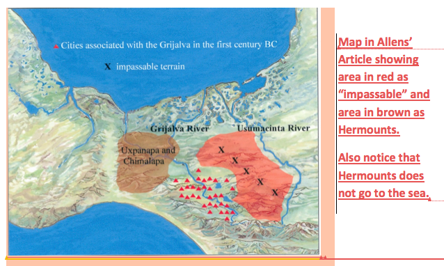
Located within Allen’s Article is the following map which shows the area between the Grijalva River and the Usumacinta to be “impassable” and therefore, according to the Allens, impossible for the Nephites to have come from the Usumacinta to the west coast area. If that were true, then how could the Nephites have gone from Santa Rosa on the Grijalva through that “impassable” area to populate and control the entire Peten, Yucatan, and Belize areas?
I submit, therefore, that if city Bountiful was located at or near Dzibanche, Yucatan, then the Grijalva River could not have been river Sidon. Either one or the other is the wrong location or, more probably, both are mistaken.
The wilderness of Hermounts could not have been the same as the Jaredite’s “land southward for a wilderness, to get game” because:
Point one: It was west-sea Bountiful, not Hermounts, that was identified as the location that was “filled with all manner of wild animals of every kind, a part of which had come from the land northward [through Desolation] for food.”
Point two: West-sea land Bountiful, according to the Book of Mormon, was located on the west seashore and Hermounts was not located on any seashore.
Hermounts was not “Bountiful.” Hermounts wilderness was not filled with “all manner of wild animals of every kind,” nor “covered with animals of the forest;” Rather, Hermounts was “infested” with “ravenous beasts.”
The only scripture mentioning Hermounts is located in Alma 2:37, 38 which states: Yea, they were met on every hand, and slain and driven, until they were scattered on the west, and on the north, until they had reached [The Nephites chased the Lamanites that 2nd day as far as the entrance into] the wilderness, which was called Hermounts; and it was that part of the wilderness, [not the whole wilderness but only a certain part of the wilderness] which was infested by wild and ravenous beasts. [Not “animals of the forest”, as Ether said, and not “all manner of wild animals of every kind” as Alma said. Note also that the Nephites did not follow the wounded into the wilderness of Hermounts, presumably because it was infested with ravenous beasts in 87 BC.]
Verse 38 confirms the above stating: “…many died in the wilderness of their wounds [the Nephites did not kill any Lamanites in the wilderness of Hermounts], and were devoured by those beasts and also the vultures of the air; and their bones have been found [some time after the battle], and have been heaped up on the earth”.
The definition of “infested” includes synonyms like “diseased,” “contaminated,” “polluted,” “infected,” and “plague-ridden.” The definition of Ravenous Beasts includes terms like “famished,” starving,” “predatory,””voracious,” and “very hungry.” I do not believe it reasonable to believe that the term “infested by wild and ravenous beasts” is synonymous with the terms “animals of the forest” or “all manner of wild animals of every kind”. While some of these “ravenous beasts” could have been included in the above descriptions, the authors of the Book of Mormon clearly distinguished between the area which was located in the west sea land Bountiful and the area that was “part of an inland wilderness” close to Zarahemla that was “infested by wild and ravenous beasts.”
I wonder how a wilderness infested with wild and ravenous beasts could possibly be considered “Bountiful” especially when Hermounts was also not located near a sea. Remember Alma 22:31 states that the “land on the southward [from the line] was called Bountiful, it [Bountiful and not Hermounts] being the wilderness which is filled [not infested] with all manner of wild animals of every kind, a part of which had come from the land northward for food.”
Why had some animals come from the land northward for food? Because there was no rain in the land northward, including Desolation. The animals traveled into the land Bountiful, south of the line, because there was rain and food there. Why were there a lot of other animals of “every kind” in Bountiful? Because Bountiful was located in an area between the Pacific Ocean on the west and the Sierra Madre Mountains on the east; And from about the line at Horcones, southward to at least the border of Guatemala and probably on south to Esquintla. This area, historically, is an area where, even when there is little rain in other areas, there is abundant moisture in this bountiful and most productive Pacific corridor, especially along the Piedmont.”
I submit that it is an erroneous assumption to believe that Hermounts is synonymous with Bountiful. Since Bountiful being synonymous with Hermounts is fundamental to the Grijalva being the river Sidon, then this part of the theory is inaccurate, and therefore, perhaps the Grijalva was not the river Sidon.
Point two
Only 3 areas in the Book of Mormon are referred to as Bountiful and they are all located adjacent to a sea. Allen’s proposed Hermounts is not located adjacent to a sea (pages 468 & 568) and therefore, this is another reason why Hermounts cannot be the Bountiful that was filled wit“all manner of wild animals of every kind, a part of which had come from the land northward for food:”
(1). The old world land Bountiful is described in 1 Nephi 17:5 “And we did come to the land which called Bountiful, because of its much fruit……we were exceedingly rejoiced when we came to the seashore; and we called the place Bountiful, because of its much fruit”.
(2). The east-sea land and city Bountiful (from 71 BC to about 30 BC) were separate from the land of Zarahemla and were located east of the land of Zarahemla bordering upon the east sea area and north of Mulek. City Bountiful was located not more than 10 miles north from Mulek (See my article Why City Bountiful was not located in the Yucatan, Peten or northern Belize at BMAF.org). Some of the scriptures that support these above conclusions are:
(About 67 BC) Alma 51:32 states,”…Teancum and his men did pitch their tents in the borders of the [east-sea] land Bountiful; and Amalickiah did pitch his tents in the borders [of the city Bountiful] on the beach by the seashore…” [Teancum killed Amalickiah that night and the next day the Lamanites retreated back to Mulek and remained there until Moroni returned with his armies from the west sea area;]
(About 64 BC) Alma 52:22, 23, 27-28 states…”on the morrow when…Teancum saw the armies of the Lamanites coming after him [from Mulek] he began to retreat down by the seashore northward…the Lamanites did pursue Teancum until they came near the city Bountiful, and then they were met by Lehi and a small army, which had been left to protect the city Bountiful….they fled in much confusion, lest perhaps they should not obtain the city Mulek before Lehi should overtake them…”[Therefore, one could travel from Mulek to Bountiful and back in less than one day. Clearly Mulek and the land and city Bountiful were located very near the east sea and within a distance of less than one half day from each other, about 5 miles or so, and certainly not 30 or 40 miles inland].
(3). The west-sea land Bountiful was also separate from the land of Zarahemla but it was located on the west sea coast and south of the line between Desolation and Bountiful which line was located just south of city Desolation and city “Lib”. This line between Desolation and Bountiful started on the west sea and ran a distance of one day to a day and a half journey eastward. (See my articles entitled, Why city Desolation could not have been located at San Lorenzo; and Why city Lib could not have been located at La Venta. Both articles are located at BMAF.org). Some of the scriptures supporting these conclusions are:
(About 85 BC) Alma 22:32 states “…it was only the distance of a day and a half’s journey for a Nephite, on the line Bountiful and the land Desolation, from the east to the west sea…” Desolation and Bountiful must border the west sea and the line between them must run from the west sea eastward about “a day and half’s journey”. Also remember that none of the Nephite cities on the east sea coast had been established yet, except perhaps Antionum, (land and city of the Zoramites). Therefore, there had not been designated an east sea Bountiful or city Bountiful until Moroni chased all the Lamanites (not Maya) out of the east sea area in the year 72 BC and then sent Nephites to the east sea area to build many new cities (see Alma 50).
(About 85 BC] Alma 22:31 states “...the land on the northward [of the line] was called Desolation and the land on the southward [of the line] was called Bountiful, it [Bountiful] being the wilderness which is filled [not infested] with all manner of wild animals of every kind a part of which had come from the land northward for food. It was this west sea Bountiful where King Lib hunted for wild animals and not in Hermounts.The term “land on the northward” is not referring to all of the greater land northward but only a small part of the “land northward called Desolation. The term “on the southward” is not referring to all of the greater land southward. Clearly all of the land southward was not the wilderness that “is filled with all manner of wild animals of every kind”. These “wild animals of every kind” were limited to that part of the greater land southward called land Bountiful that was south of the line. Apparently some of the animals came from the land northward (during the drought at the time of the serpent plague) through land Desolation (not across the Coatzacoalcos River) into the west sea land Bountiful where there was rain.
There should be no doubt but that each of the 3 lands Bountiful, identified in the Book of Mormon, were located adjacent to a sea.
Hermounts was not located by the sea; was not part of land Bountiful; did not contain animals of every kind as did Bountiful; was not the area where many animals came to from the land northward; and was not the area where King Lib hunted for animals of the forest. Therefore, city Zarahemla was probably not located on the Grijalva River.
ASSUMPTION NO. (5)
The 2nd day of battle between the Amlicites and Nephites in 87 BC took no more than one day to complete. Therefore, Hermounts was too far (100 air miles) from Santa Rosa (Zarahemla) to be reached in less than one half of one day. Either one or both proposed locations are wrong according to the Book of Mormon.
I have pondered this question many times. A “careful reading of the Book of Mormon” requires that the 2nd day’s battle took place in only one day. This included both armies leaving early in the morning to see who could get to city of Zarahemla first. They met at the crossing of river Sidon perhaps about the middle of the day and the battle commenced with the Lamanites pinning the Nephites in the river Sidon. Struggling for a short time, Alma finally killed Amlici and then cleared the bank so his soldiers could climb out of the water. Once the Nephite army got up on the west bank, the Amlicite/Lamanite armies fled towards the west and then north with the Nephites chasing them and killing most of them. The Nephites continued chasing them “with their might” that same day “until” they came to that part of the wilderness that was west and north called Hermounts. The Nephites did not go into Hermounts but the wounded Lamanites did. It is only at this point in the narrative that there is any indication of a break in the action.
Therefore, one can reasonably conclude that the wilderness of Hermounts cannot be farther than 3 or 4 hours west and north from the crossing of river Sidon which was located near Zarahemla. I submit that this distance could not have been more than 12 miles or so and probably more like 6 to 8 miles because of the long day of marching, fighting and then fleeing while wounded. The scriptures supporting this conclusion are as follows:
(About 87 BC) Alma 2:15. … the Amlicites came upon the hill Amnihu, which was east of the river Sidon, which ran by the land of Zarahemla, and there they began to make war with the Nephites. [Notice the war was not with the Nephite army yet. Apparently the Amlicites desired to get the Nephite army out of Zarahemla so that the Lamanite army descending from Nephi on the south through Minon could possess Zarahemla].
16. Now Alma, being the chief judge and the governor of the people of Nephi, therefore he went up with his people. Yea, with his captains and chief captains, yea, at the head of his armies, against the Amlicites to battle.
17. And they began to slay the Amlicites upon the hill east of Sidon. And the Amlicites did contend with the Nephites with great strength, insomuch that many of the Nephites did fall before the Amlicites. [This is the start of the first day’s battle].
18. Nevertheless the Lord did strengthen the hand of the Nephites, that they slew the Amlicites with great slaughter, that they began to flee before them.
19. ..The Nephites did pursue the Amlicites all that day and did slay them with much slaughter, insomuch that there were slain of the Amlicites twelve thousand five hundred thirty and two souls; and there were slain of the Nephites six thousand five hundred sixty and two souls.
20. And... When Alma could pursue the Amlicites no longer he caused that his people should pitch their tents in the Valley of Gideon...for the night.
21. And Alma sent spies to follow the remnant of the Amlicites....
22.
23. And... on the morrow they returned into the camp of the Nephites being greatly astonished and struck with much fear, saying: [Therefore, the maximum distance between Minon and Gideon could not have exceeded ½ night’s march, not over 5 to 10 miles].
24. Behold, we followed the camp of the Amlicites, and to our great astonishment, in the land of Minon, above the land of Zarahemla, in the course of the land of Nephi, we saw a numerous host of the Lamanites; and behold, the Amlicites have joined them [Minon and Nephi were south of Zarahemla and Minon was up in elevation from Zarahemla and therefore , in the foothills of the narrow strip of mountainous wilderness];
25. And they are upon our brethren in that land; and they are fleeing before them with their flocks, and their wives, and their children, towards our city; and except we make haste they obtain possession of our city, and our fathers, and our wives, and our children be slain. [They believed that if they hurried they could reach Zarahemla ahead of the Lamanite/Amlicite armies in one day. Therefore, Gideon and Minon could not have been more than 20 to 25 miles from Zarahemla.]
26. ... and the people of Nephi took their tents and departed out of the valley of Gideon towards their city, which was the city of Zarahemla.
27. And behold, as they were crossing the river Sidon, [sometime in the early afternoon] the Lamanites and the Amlicites, being as numerous almost, as it were, as the sands of the sea, came upon them to destroy them.
28. And...Alma fought with Amlici....
29.
30.
31. …and slew Amlici with the sword.
32.
33. But Alma with his guards contended with the guards of the King of the Lamanites until he slew and drove them back
34. And thus he cleared...the bank, which was on the west of the river Sidon, throwing the bodies of the Lamanites who had been slain into the waters of Sidon, that thereby his people might have room to cross and contend with the Lamanites and the Amlicites on the west side of the river Sidon.
35. And...when they had all crossed the river Sidon that the Lamanites and the Amlicites began to flee before them, notwithstanding they were so numerous they could not be numbered.
36. And they fled before the Nephites towards the wilderness which was west and north, away beyond the borders of the land [near city of Zarahemla], and the Nephites did pursue them [that same afternoon] with their might and did slay them.
37. Yea...until [meaning they continued that same afternoon] they were scattered on the west and on the north, until they reached the wilderness, which was called Hermounts. [The battle that second day did not stop until the remainder of the Lamanites and Amlicites had entered Hermounts].
Notice how the Nephite armies on the first day (see verse 20) pursued the Amlicites “until” they could pursue them no longer because it was night. I submit that verses 36 and 37 show that the Nephites pursued them “with their might” that second day “until” they could pursue them no longer because the remnant Amlicites/Lamanites had entered Hermounts which was “infested with wild and ravenous beasts.”
I submit that there was a very close relationship between Zarahemla and the locations of Gideon, Minon, the crossing of the river Sidon, Melek, Ammonihah and Sidom and Hermounts as demonstrated in my article, Footprint of Zarahemla, located at BMAF.org, as required by the Book of Mormon. I now believe the distances on my map, shown hereafter, should be several miles shorter in each case. The shorter ranges of distances as stated on the map below are probably the more accurate.
There is no distance stated on the map for Hermounts, however, I now believe, as stated above, that the distance between the crossing of Sidon where the battle began that second day, and the wilderness of Hermounts could not have been over 12 miles or so.
The objection to this conclusion, of course, is that the Lamanites/Amlicites “…fled before the Nephites towards the wilderness which was west and north, away beyond the borders of the land and the Nephites did pursue them with their might, and did slay them”. I believe it is more compelling that the total battle on the 2nd day was limited to one day and that the term “beyond the borders of the land” must refer to beyond the borders of the lesser land or farmlands and populated lands around the city Zarahemla. Below is a satellite map showing terrain and distances in the area:
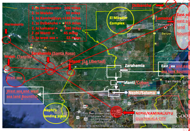
Google map of Book of Mormon lands. (Allen = red and circles. Hauck/Andersen= white and squares. Yellow circle = areas common to both. Yellow lines = Boundaries of Guatemala and Belize).
According to the Allens the distances are about: According to Hauck the distances are about:
1. Z. To Hermounts = 100 air miles Z. to Hermounts = 8 ground miles
2. Z. to Melek= 90 air miles zz Z. to Melek =(within Zarahemla) 25 ground miles
3. Z. to Dzibanche= 315 air miles Dzibanche is not a Nephite city
4. Z. to Kaminaljuyu= 160 air miles Z. to the Salama valley = 70 air miles
5. Z. to Manti= 45 air miles Z. to Manti = 45 air miles
6. Z. to Lamanai= 280 air miles Lamanai is not a Nephite city
7. Z. to west sea= 55 air miles Z.to west sea 120 air miles
8. Z. to east sea = 300 air miles Z. to east sea (Bountiful)= 90 air miles
The distance between Santa Rosa (Zarahemla) in the Grijalva basin and Allen’s proposed Wilderness of Hermounts is about 100 miles by air. The terrain between these two locations is very mountainous and difficult to traverse. I submit that the army of Alma did not chase the Lamanite/Amlicites from near Santa Rosa, Mexico, 100 miles to the Uxpanapa/Chimalapa wilderness across the very rugged Sierra Madre Mountains in less than one half day.
There is certainly room for disagreement here, however, I believe it preferable to take the Book of Mormon at its precise wording which is that the battle was “pursued with their might” on the second day and it did not cease until the wounded Lamanites/Amlicites had entered the wilderness of Hermounts.
I believe it must be concluded that, according to the Book of Mormon, Hermounts could not have been located more than 10 to 12 miles west and north from the city of Zarahemla. Therefore, if Hermounts was the Uxpanapa-Chimalapa wilderness then Santa Rosa could not have been Zarahemla and the Grijalva River was probably not the river Sidon.
ERRONEOUS ASSUMPTION NO. (6)
Melek was not located 90 miles from Zarahemla. It was not located west of any wilderness. It was not located by the west sea.
At the beginning of the 10th year of the judges Alma departed Zarahemla and “…from thence...took his journey over into the land of Melek on the west of the river Sidon, on the west by [not in or beyond] the borders of the wilderness” (Alma 8:3-5). He went towards the west from Sidon (at least from some point near Zarahemla) until he came to the borders of a wilderness (perhaps mountainous) area. Notice he did not go into the wilderness nor did he cross the wilderness. He clearly stayed within the borders of the land of Zarahemla, at least that part of the land that the Nephites maintained political, social, and religious influence at that time (about 81 BC).
This wilderness area could have been part of the narrow strip of wilderness that was just to the south of Zarahemla and above Minon, or it could also have included another wilderness area on the west side of Melek. It is more reasonable and logical that this was a west wilderness that went from the narrow strip of mountainous wilderness northerly past Ammonihah. Ammonihah was located mostly north of Melek and was also in the borders of the land of Zarahemla, but not in or beyond the western wilderness (Alma 16:2 and Alma 8:6).
How far west of Sidon and Zarahemla was Melek located?
About 82 BC Alma began his missionary journey to Melek from Zarahemla. Alma 8:3 states “...Alma departed from thence and took his journey over into the land of Melek, on the west of the river Sidon...” “Thence” used here clearly referred to his home at Zarahemla. Therefore, Melek should be westerly from Zarahemla. Because he went from Zarahemla, already on the west side of Sidon, and went “over” into the land of Melek, “on the west of river Sidon,” it seems possible that Alma could have crossed a different branch of the Sidon, otherwise why say on the west of Sidon?
It seems clear that Alma was trying to establish the church in all the major cities close to Zarahemla and, therefore, Melek was not a great distance from Zarahemla but something like the distance to Gideon. As Gideon was the closest major city south-eastward of Zarahemla (having been built by Gideon about 5 years earlier), Melek was likely the closest major city westward of Zarahemla. This was 7 years before the Ammonites were resettled there from Jershon (Jershon was located near the east sea area and down from Manti) and about 8 years before Moroni colonized the east sea area after cleansing the entire east wilderness of Lamanites and sending them all back to their own lands south of the narrow strip of wilderness: Alma 50:7 confirms: “…they went forth and drove all the Lamanites [not Maya] who were in the east wilderness into their own lands which were south of the land of Zarahemla”
It must be recognized that Melek was never attacked and that it was perhaps the safest place for the relocation of the people of Ammon from Jershon. Once the people of Ammon were relocated there (74 BC) Melek became a large city (of at least 10,000 Ammonites in addition to the Nephites). Melek was a righteous city where 2,060 stripling righteous warriors were reared, and later sent to the western battle front that extended from Manti to Cumeni to the west coast “south” area (Alma 52:11 & 53:22).
The Nephites had covenanted to protect the Ammonites (Alma 27:23-24), and therefore, it is more probable that they would not have been relocated in, or beyond, the west or south wilderness where they would have been hard to defend, but would have relocated them in a very strategic political, religious, and militarily defensive location that was also close to Zarahemla within not more than 30 miles.
The Ammonites also pledged “...on condition that they will give us a portion of their substance to assist us that we may maintain our armies....” (Alma 27:24). Therefore, Melek must have been close enough for them to help provide for the Nephite armies with produce that could have been relatively easy to transport to Zarahemla. Author Richardson Benedict Gill agrees with studies that prove that the maximum distance foods could be reasonably transported by humans walking to a major city/state would be about 18 to 30 miles or the “radius of one day’s journey” (The Great Mayan Droughts, Gill 2000, page 77).
It is also probable that Melek was located in a large and favorable agricultural area as it had to support a population, including Ammonites, of about 15,000 to 20,000 inhabitants and supply goods for the Nephite army as well. It is unlikely that this would have been in the wilderness or mountainous area, although it seems to have included at least “by” the wilderness side. The people came to hear Alma for “...the people came to him throughout all the borders of the land which was by [not in or beyond] the wilderness side….” (Alma 8:5).
The Lamanite armies clearly had to travel west of Melek, in the wilderness on the west, in order to attack Ammonihah from the “wilderness side,” supporting the belief that Melek was close to Zarahemla (Alma 16:2 and 25:2) and east of a wilderness on the west of Melek. It seems likely that Melek, like Gideon, was as close as 15 miles but not over 30 miles from Zarahemla. If Melek was located at or near Tonala (90 miles from Santa Rosa) near the west coast, then the Lamanite army that destroyed Ammonihah would have traveled right by Melek. Why travel another 3 days farther north to attack Ammonihah when they could have obliterated Melek so easily if it was located at Tonala?
Therefore, I do not believe that Melek could have been located 90 miles from Zarahemla. It could not have been located west of the rugged and high Sierra Madre Mountains, and it could not have been located near the west coast. To locate Melek at or near Tonala does not conform to what “a careful reading of what the Book of Mormon says.” I submit, therefore, that the proposed locations of Melek on the west coast and Santa Rosa on the Grijalva are both probably incorrect.
If Dzibanche (in the Yucatan) was city Bountiful and if the Pacific Ocean, near Izapa, was the west sea then the Grijalva River at Santa Rosa could not have been the river Sidon because it was not located in the “center of the land” of the Nephites.
Having established that the narrow strip of mountainous wilderness was the area of the Sierra Cuchumatanes and Sierra de la Minas in Guatemala, (or perhaps Sierra de Santa Cruz)(and I believe there is no other realistic possibility) then the general area for the location of the city of Zarahemla relative to the narrow strip of wilderness and relative to the east and west seas might be ascertained. We should be able to determine a probable distance from the narrow strip of wilderness either on the Grijalva or the Usumacinta river systems (including major tributaries). Both of these rivers begin in the highlands of Guatemala near Huehuetenango and run northerly toward the Gulf of Mexico. Large tributaries to the Usumacinta begin near Coban, Guatemala. There are no tributaries to the Grijalva that are located near Coban. While the exact location of Zarahemla cannot be determined yet, what can be determined is where Zarahemla is probably not located.
Zarahemla was the political, economic and religious center of the Nephite sphere of influence at least from the first year of the reign of Mosiah 1 (about 200 BC) for about 500 years. Zarahemla was located in “the center of our land” (Helaman 1:24, 27) and was in “the heart of our country” (Alma 60:19). It was the “capital city” and near the “capital parts of the land” (Helaman 1:27). It was also located north from and yet “by” the narrow strip of mountainous wilderness (Alma 22:27). Zarahemla was located north and down from Manti (Alma 56:25) and Manti was located about midway between the east and west seas. Jershon was located near the east sea and down from the headwaters of Sidon which were located southward and up in elevation from and yet near Manti (Alma 56:25 & Alma 43:22 & 27:22-26).
The Grijalva basin is not near the center of the land between the east and west seas and it is not near the center of the narrow strip of wilderness where Manti had to have been located. The Grijalva basin is also not near the “capital parts of the land including the many east sea cities. Therefore, Santa Rosa on the Grijalva was probably not the city of Zarahemla.
Zarahemla would also have been located easterly from the landing place of Lehi (Alma 22:28) and westerly from the cities of Moroni and Lehi, both of which were just north of the eastern end of the narrow strip of wilderness near the Gulf of Honduras (Alma 50:10-15).
This means that Zarahemla should have been located just northerly of the narrow strip of wilderness down in the Usumacinta basin and in the center of the land between the east and west seas. Zarahemla would not have been farther than 50 miles or so south from the narrow strip of wilderness where Manti was located. Since the Usumacinta basin, north of the confluence with the Passion River, is a better agricultural area than the Grijalva Basin; and since the Usumacinta basin had better prospects of sustaining larger populations; and since it is more in the center of the land between the east and west seas; and since it is closer to the “capital parts of the land” including the many east sea cities; and since there is a major salt source close by (Deciphering the Geography of the Book of Mormon, Hauck 1988 at pgs 140-153), then it seems much more likely that Zarahemla would have been located somewhere along the Usumacinta River Basin or one of its major tributaries and not in the Grijalva basin.
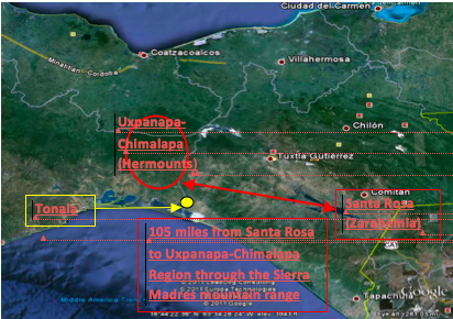
Allens’ Article, mistakenly states that it is “less than 50 miles” from Santa Rosa to the Uxpanapa-Chimlapa Region The actual quote is: “The distance due west from Santa Rosa on the Grijalva to Uxpanapa-Chimalapa is less than fifty miles—a very realistic distance for warring armies to cover in connection with the time available and the terrain of the area”.
The correct distance by air is more than 100 miles from Santa Rosa due west to the closest point of the Uxpanapa/Chimalapa wilderness as shown on the actual maps below. I submit that 100 miles of difficult terrain in the Sierra Madres Mountains was not a “realistic distance for the warring armies to cover in connection with the time available and the terrain of the area”. I also submit that the “time available” was certainly less than a half a day.
Notice the location of the Uxpanapa-Chimalapa Region as described in the following Satellite map of the region.
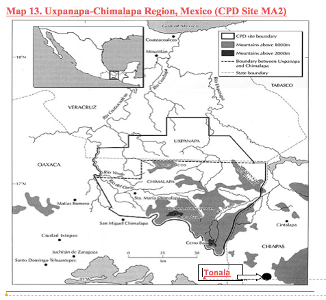
Now notice the actual location on Map No. 13 (CDP Site MA2) of Mexico maps below
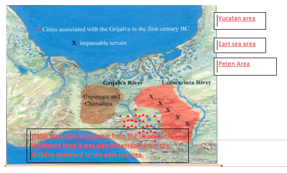
The following map from Allen’s Article shows the entire area east of the Grijalva as “impassable” from the Usumacinta to just east of the Grijalva River. If that were true then that same area would have been impassable for the Nephites, living at Santa Rosa, to have traveled to the Yucatan or the Peten or Belize to establish many cities in those locations. It seems even more improbable that the church headquarters would have changed from Santa Rosa to Dzibanche, Yucatan 315 air miles away and across the “impassable” Lacadon wilderness. I submit that all of the cities east and north of that” impassable area” would have been outside the “capital parts” of the land of Zarahemla (if at Santa Rosa) and outside the political, social, economic, and religious sphere of influence of the city of Santa Rosa. Since there were many cities in the east sea area, including Jershon where the Ammonites were located under of the protection of the Nephites, then I further submit that the city of Zarahemla on the Grijalva River must be in the wrong location, being much too far and remote from the east sea cities.
La Libertad (proposed Manti in Exploring), contrary to what the distorted maps show at pages 773 and 678, is not located southward from Santa Rosa as required by the Book of Mormon. La Libertad is located almost due east, (see Google map at page 16 above) although it is within the required 50 miles or so distance from Santa Rosa. It seems to me that the Book of Mormon requires the relationship of Zarahemla, Minon, Manti, and the city of Nephi to be almost north/south of each other and not mostly east as is the relationship of Santa Rosa to La Libertad and then to Kaminaljuyu. Since Manti should be located mostly south of Zarahemla then La Libertad is probably not Manti and Santa Rosa is probably not Zarahemla and of course, the Grijalva is probably not river Sidon.
There is strong evidence that the City of Coban, located in the only pass through the middle of the narrow strip of mountainous wilderness, was the city of Manti. Even today it is a major crossroads and commercial hub in the center of the country. Archaeologist Richard Hauck is confident this is Manti and he has discovered many Pre-classic defensive trenches and defensive locations that assure him (and Garth Norman concurs) that Coban is probably the city of Manti (Deciphering the Geography of the Book of Mormon, Salt Lake City, Deseret Book Company, 1988). I submit that if Coban is Manti then the Grijalva River cannot be the Sidon.
The Book of Mormon requires Minon to be directly in the path from Zarahemla to Manti to Nephi. Nephi must be located mostly southward from Zarahemla. Therefore, Minon cannot be located eastward or northward as is shown on page 678 of Exploring, (see map below).
1. Since one of the premises for claiming that the river Sidon was the Grijalva was that there were “no cities along the Usumacinta River from 300 BC to AD 250;” and since that is an untrue premise, then the Usumacinta River is not precluded from being the Sidon and one must begin to question the validity of the Grijalva as being the river Sidon.
2. Since another premise for supporting Allens’ geography is that the “east wilderness of Zarahemla” included all the Peten, northern Belize and part of the Yucatan; and since that is also an untrue premise, then one must begin to question other presumptions like how could city Bountiful possibly have been located in Yucatan north of the massive Mayan populations in Peten and Belize? And how could the Nephites at Santa Rosa have controlled more than a million Maya in the Peten? Maybe the Grijalva River was not the river Sidon.
3. Since Kaminaljuyu could not have been the city/land of Nephi; and since there is no other proposed nor logical site, between Kaminaljuyu and La Libertad, that qualifies as Nephi; and since Nephi cannot be located within the narrow strip of wilderness but must be located south of but near said wilderness, then I conclude that Santa Rosa on the Grijalva could not have been Zarahemla, there being no qualifying city of Nephi southerly from Santa Rosa and La Libertad.
4. Since Melek must have been located within 30 miles westward from Zarahemla and yet east of the west wilderness; and since there is no evidence of such a qualifying Pre-classic site having been located west of Santa Rosa, then Santa Rosa could not have been Zarahemla and the Grijalva River was probably not the river Sidon.
5. Since Zarahemla must have been located in the center of the Nephite lands between the east sea and the west sea; and since Santa Rosa and La Libertad are both located much closer to the west sea than the east sea, then both of these cities are not located in the middle of nor in the center of the Nephite lands. Therefore, they were probably not the cities of Zarahemla and Manti.
6. Since the claim has been made that city Bountiful was located at or near Dzibanche, Yucatan, then I submit that if that is true then Zarahemla could not have been located 315 miles away on the Grijalva River. Not only does this emphasize the conclusion that Santa Rosa was not in the center of the Nephite lands but Nephites at Zarahemla must have been able to have controlled all of the lands between Dzibanche and the west coast. I submit the impossibility of such a situation. I also submit that there is no evidence that any other nation, people, religion, or culture, like the Nephite culture, ever interfered with, converted, or assimilated the more than one million Maya in the Peten into the Nephite sphere of influence. Such preposterous claims that Dzibanche was city Bountiful and that the church headquarters was moved there should make one pause and reconsider all of Allens’s geographical claims.
7. Since Hermounts could not have been located more than 4 or 5 hours away from Zarahemla, then Hermounts could not have been the Uxpanapa-Chimalapa Region and therefore, Santa Rosa as Zarahemla is in the wrong place and the Grijalva River is probably not the river Sidon.
8. Since Hermounts was not located by a sea and west land Bountiful was; and since it was the west-sea land Bountiful on the west sea that was filled with all manner of animals where King Lib hunted and not Hermounts, then the major premise for locating Zarahemla on the Grijalva is invalid and the probability that the Grijalva River is not the Sidon is greatly increased.
9. Since Minon must have been located “in the path” (southward) toward city Nephi and since Exploring shows Minon to be east and north from Santa Rosa instead of south, as required by the Book of Mormon then either Minon or Zarahemla is incorrectly located or probably both are.
While I am personally convinced that the Grijalva River is probably not the river Sidon, I submit that one thing is “unequivocally” true: The Grijalva River is not “unequivocally” the river Sidon.