


Mapping Book of Mormon Geography 101
Mapping Book of Mormon Geography 101
by Lawrence Poulsen
Recently there have been a number of new discoveries in the Americas that have brought new information about cultures existing during the Book of Mormon time periods. Before these findings can be correlated with the Book of Mormon it is necessary to decide where the Nephites, Lamanites and Jaredites were located geographically.
In his review of Richard Hauck's book on Book of Mormon Geography, John Clark makes the following statement:
It has been my experience that most members of the Church, when confronted with Book of Mormon geography, worry about the wrong things. Almost invariably the first question that arises is whether the geography fits the archaeology of the proposed area. This should be our second question, the first being whether the geography fits the facts of the Book of Mormon-a question we all can answer without being versed in American archaeology. Only after a given geography reconciles all of the significant geographic details given in the Book of Mormon does the question of archaeological and historical detail merit attention. The Book of Mormon must be the final and most important arbiter in deciding the correctness of a given geography; otherwise we will be forever hostage to the shifting sands of expert opinion.
He then goes on to give a set of criteria, which he considers useful in evaluating the text of the Book of Mormon in relation to its geography. His choice of criteria leads him to a map similar to that proposed by Sorenson.
In this thread we will attempt to establish a set of criteria understandable by those just beginning to develop their own view of Book of Mormon Geography. We will start by listing the tools available to the beginner and then go on to establish definitions for the various geographical terms found in the text of the Book of Mormon.
A number of years ago Delorme released a program that allowed the user to view any location on earth in both 2D and 3D maps generated from satellite photographs.
Using this program, I was able to compare the text of the Book of Mormon with the actual geography from my armchair in my computer room without the expense of traveling all over the world in search of areas whose geography matched the textual descriptions. The program was taken off the market shortly after I purchased it and this option was not available to the armchair geographer until the recent release of Google's Google earth.
Want to know more about a specific location? Dive right in -- Google Earth combines satellite imagery, maps and the power of Google Search to put the world's geographic information at your fingertips.
So pull up your armchair, download the program, its free, get out your copies of the Book of Mormon and the 1828 edition of Webster's Dictionary and develop your own view of Book of Mormon Geography. As Clark says don’t "be forever hostage to the shifting sands of expert opinion.”
Oh, you don’t have a copy of the 1828 edition of Webster?, well here is a link to an online searchable version:
http://65.66.134.201/cgi-bin/webster/webst...r_texts_web1828
Why the dictionary? Because the English language has evolved since Joseph Smith completed the translation in 1830 and our culture has also changed from an agrarian frontier culture to an urban industrial culture and we need to check to be sure we understand the geographical and directional terms used by Joseph Smith in the translation of the plates to the English language. Because of our familiarity with the Bible language, we have little trouble understanding the spiritual concepts found in the Book of Mormon, but modern concepts of geography are in many ways different from those held by the common man in Joseph Smith's day.
Consider the following:
spoke and used it. For this reason, it is incumbent on our part to understand his culture and the differences from ours when looking for meaning in the text of he Book of Mormon. Spiritually, it is usually very easy because his culture was firmly based on the Bible, as is the modern Mormon culture in our day. However when trying to understand non- spiritual aspects of the text such as the surrounding non-Nephite culture, the Nephite and Lamanite attitude toward war, and geography, we need to exercise caution. With reference to the geography described in the Book of Mormon, we should not apply our modern cultures’ concepts to the interpretation of geographical terms and directions found in the text.
For example, our culture thinks of directions based on a compass with our maps oriented towards North. Pre-Columbian cultures thought of directions with relation to themselves and their orientation to the sun and the world around them. They oriented their maps to the east and included directions such as "up" to designate higher elevations and "down" to indicate lower elevations. East was always where the sun rose and not a fixed direction based on a magnetic compass or a GPS satellite unit. All other directions were relative to the sun's rising, location in the heavens, and setting. This may sound imprecise but remember, they were more concerned with where they were and less so about where everything else was. So as we contemplate a search for the original hill Cumorah, let us remember that Mormon was not so greatly concerned about where it was, thus the poor descriptions of its location, but what it could do for his position in defense of his people against the Lamanites
Don’t be lazy. It may take a little thought and perseverance but you too can do it. After all you don’t have to leave your armchair or your computer screen.
Seriously, if you want to gain an understanding of Book of Mormon geography, you have to do some geographical investigation on your own.
For example:
Look up a scripture in the Book of Mormon that describes a geographical feature. Then write down all the possible ways that scripture could be interpreted in terms of geography and directions. If you only list one possibility, you are relying too much on expert opinion and not thinking it out for your self.
Remember that when Oliver Cowdery wanted to translate and failed he was given the following instruction:
|
D&C 9:8 |
Use the 1828 Webster to check your interpretation of the information found in the text and then get out your maps and look for an area or areas in the Americas that fits each of your interpretations. There may be more than one so keep track of all of them so you can determine if they converge with other locations and information.
Don’t be discouraged if it starts to look complicated, it will get simpler the more you learn.
Any ethnohistoric reconstruction I know of attempts to fill in the knowledge gaps with reasonable inferences from cultures or situations that are plausibly parallel. The problem is that the simplistic methodology of creating lists of "parallels" has so muddied the methodological waters that if nothing else, convergence is a term that allows for the preservation of the good without the unfortunate bad baggage of the poor methodologies.
Parallels, in and of themselves, are next to useless. Sometimes the items paralleled are clearly parallel, but the parallels could easily be due to independent invention. One such is the "parallel" of using adobe in the Old and New Worlds. That is certainly parallel - but meaningless. There is nothing inherently unique about sun-dried mud.
Other problems in parallels are that many times "parallels" are created by the way they are described. Things that really have no relationship to one another at all can be made to appear "parallel" if worded correctly. That doesn't make them useful - it makes them deceptive.
The concept of a convergence is much more useful because it understands that there is no single point of comparison that really shows anything. What is required is multiple points of simultaneous and interconnect comparisons. The more you have multiple parallels that are unique and interconnected in non-random ways, the more likely that there really is a connection.
However, even with those kinds of convergences there is a lot required before one can say that two otherwise disconnected cultures share time and space in a meaningful way. My favorite example is an Indonesian (Balinese) Garuda carving I have on my desk. The Garuda is a man-eagle who carries Arjun on his back. He has a man's body but bird wings. Most fascinating to me is that he wears a bird mask that has teeth. In addition, at the back of the toothed beak are two large backward curving teeth. Around the connection of the beak to the face is a beard-fringe. This is visually identical to the buccal mask on Mesoamerican Quetzalcoatl figures.
This is a highly arbitrary connection that cannot rely on nature (what bird has not only teeth, but that kind of dentition?). Nevertheless, it is insufficient to demonstrate connection because I cannot currently connect the images in time. Without knowing that there is a time period when they coexist I can't even begin to posit a relationship.
That is where convergences begin to make our case. In the case of the Garuda I have some convergences, but not enough. Enough to be curious and warrant investigation, but insufficient for a conclusion. I need more.
In the case of the Book of Mormon we require similar convergences. They must be similarly arbitrary, consisting of elements that would not normally be seen in that combination. In addition, however, there are further requirements of time and space. There are so many areas in which the text must converge with the real world that when the convergences in each of those areas continue to amount, there is evidence that there is a connection.
That was the basic thrust of my FAIR presentation. There are a large number of non-arbitrary ways in which the text converges with a time and place. Obviously, some are stronger than others, but the continued mass of data that continue to converge on the same place, timeframe, and culture makes it more difficult to dismiss the case as arbitrary.
I asked Brant to insert this brief essay because the purpose for understanding Book of Mormon geography should be to gain better understanding of an important factor, which impacted the Nephites and their interactions with the Lamanites. Its purpose is not to produce a testimony of its truth but to add to and enhance the testimony we already have.
Convergence between geography and the Book of Mormon story as it emerges from the writings of Nephi and his family and the abridgment of Nephite history provided by Mormon is necessary in order for any attempt to define Book of Mormon geography to be useful and/or convincing.
Brant’s statement:
Brant:
The concept of a convergence is much more useful because it understands that there is no single point of comparison {Substitute that geographic feature or location} that really shows anything. What is required is multiple points of simultaneous and interconnect comparisons. The more you have multiple parallels {again substitute geographic feature or location} that are unique and interconnected in non-random ways, the more likely that there really is a connection.
Ground rules and Cautions
Language of translation
Joseph Smith’s culture
Science and geography
Geographic features that change rapidly
Geographic features that change slowly
Artifacts and ruins
Joseph Smith's education, at the time he translated the plates, was in all probability similar to any other youth living on the western frontier. His family had a copy of the Bible and history indicates that he was quite familiar with its content and was able to read it by himself. There is no indication that he or his family owned an extensive library but this does not preclude the possibility that they had other books, possibly those used by local schoolteachers. Although his family may not have been able to afford their own copy of Webster's 1828 dictionary, there is little doubt that he spoke and understood the language, which is reflected in that dictionary.
As reported on the title page of the Book of Mormon, translated from words written by Moroni, the purpose of the book and the matter of the translation were:
Wherefore, it is an abridgment of the record of the people of Nephi, and also of the Lamanites--Written to the Lamanites, who are a remnant of the house of Israel; and also to Jew and Gentile--Written by way of commandment, and also by the spirit of prophecy and of revelation--Written and sealed up, and hid up unto the Lord, that they might not be destroyed--To come forth by the gift and power of God unto the interpretation thereof--Sealed by the hand of Moroni, and hid up unto the Lord, to come forth in due time by way of the Gentile--The interpretation thereof by the gift of God.
To fulfill this purpose the language used in the translation would have to be that of the common people or in other words the language of his peers as reflected in the dictionaries of his day. The interpretation was to be by the gift and power of God and not by the learned men of his day or our day. Even though Joseph Smith may have been limited in knowledge and may not have had an extensive vocabulary outside of that found in the Bible, the Holy Ghost would have ensured that he chose the correct words and usage of his times.
Unfortunately, our culture and the meaning of words has changed over the last 150 years so we must be cautious of imposing modern meanings and words onto the language used by Joseph Smith in his translation of the sacred records.
I will talk more about the culture of the western frontier in Joseph' day when we consider the topic of directions. But for now here is a homework assignment.
At the University of Texas, where I taught and did research until I retired, there is a faculty lounge call "Forty Acres.” In western movies and novels one often finds the authors referring to "The south forty.” Your assignment is to consider these terms, which originated in the western frontier culture of the 19th century and what is their significance with relationship to that culture's view of geography.
Geography is a part of science and includes more than just maps. It is concerned with the relationship between man and his surroundings. Maps are only useful if they enhance or qualify our understanding of the relationship between man, his culture and the environment. Even though it is convenient to propose theories about Book of Mormon geography that invoke major changes in the geography of the American continents, in order to justify a map of our favorite location for the Book of Mormon culture, there is no geological indication that such changes have taken place. Evidence for rapid changes in the surface of the land, such as changes in the course of rivers, new volcanoes, buried cities and minor changes in the location of the seashore relative to the land mass are plentiful but any major rapid shift in the level of the land mass would have been felt around the world and be easily detected in the geological record. Major changes of this nature occur very slowly. When considering locations for the Book of Mormon culture we should be sure it fits into the known areas and time frames where pre-Columbian cultures with the attributes of the Nephites and Lamanites have been shown to exist. This does not preclude the possibility of locating them in an area where we have as yet no information about past cultures but those areas are getting fewer and fewer.
Finally a word about artifacts and ruins. Any attempt to make the geography fit the existence of particular kinds of artifacts or to equate the location of Book of Mormon cities with the locations of particularly fascinating ruins should be highly discouraged. If the map, based only on the text, suggests such a correlation, it might lead to a convergence as more data about Book of Mormon culture and the culture of the area of the ruins and its time frame are brought into play. It should not, however, be the object of the proposed geography to attempt to show that the ruins are part of the Book of Mormon culture.
One of the major problems of Book of Mormon geographers is the failure to establish ground rules before starting to sort out the many descriptions and references to geography found in the Book of Mormon. Another is the failure to establish the meanings of geographical terms such as sea, up, down and the cardinal directions as used in Joseph Smith's time and culture and/or in pre-Columbian cultures of the Americas. These criteria should be carefully thought out, written down and followed. If not, contradictions will be introduced into the model as a result of introducing new assumptions as you go along.
The following list includes most of, but not all of my assumptions, and the ground rules I feel are important:
From my website.
Getting Things straight
1. Joseph Smith translated the Book of Mormon by divine power and it is the most correct book of scripture that we presently have. This however, does not say it does not contain errors and/or ambiguities in grammar. Both Mormon and Moroni expressed their concern about possible errors. This does not, however, give us license to resolve problems with our interpretation of geography by claiming that they were in error or that Joseph Smith mistranslated that concept.
2. He translated it into the English language based on what he spoke and the use of words and directions with which he was familiar. This is not necessarily the same as what we are accustomed to in our urban culture of today. However, it is a true and correct translation. We must, therefore assume that all directions were translated correctly and did not result from a misunderstanding by Joseph Smith of the Book of Mormon culture in relation to the agrarian culture of upper New York State in the early 1800s.
3. The Book of Mormon is a lineage history, an abridgment of many records recorded (with great difficulty) on a limited number of gold plates and therefore many descriptions of activities described and battles may be more abbreviated and shortened than what we might expect from a contemporary description of similar events. Because of the difficulty in engraving on the plates we must accept the probability that Mormon only included that, which was important and useful to the future reader of his words.
4. We must accept geographical descriptions as carrying more weight in determining relative locations than distances calculated by assuming travel distances based on calculations of the time it took to carry out different and varied activities described in the Book of Mormon. There should be agreement with the type of geography and the nature of the activity, but the size or the distance covered may be greater or less than our assumptions would suggest. However, all areas described should be in the right place with respect to what is said in the text. This may require us to reexamine our preconceived assumptions and their effect on our interpretation of the scriptural text.
5. And finally, we must take great care in attempting to fit our map to areas based on the existence of ruins and our assumptions about their identity to book of Mormon locations.
6. We must, however, base our assumptions on the known data concerning the cultures of Mesoamerica, the times these cultures existed and the geographic areas they occupied. The Jaredite culture must exist at a time with literate cultures known to have existed no earlier than 3000 B.C. and which essentially disappeared shortly before the birth of Christ. The Olmec culture is generally accepted to have existed during this time. We could, of course, assume a very limited area where little or no data is available and propose anything that pleases. This is inconsistent with population descriptions and statements in the Book of Mormon about the extent to which the lands were occupied. It is unreasonable to think that Joseph Smith would have inaccurately translated these concepts. The Olmec culture occupied the lowland areas on the Atlantic coast from Veracruz on the west to Villahermosa on the east. Although it is tempting to equate the Jaredites with the Olmec culture, care should be taken in doing so. Recent evidence has shown that cultures similar to the Olmecs and in the same time period have been found in the area near Tampico far from the Olmec heartland. On the other hand, the Nephite culture ended before 600 A.D. and cannot be equated with either the Aztec or Inca cultures which did not arise until after 1000 A.D. The Nephite culture is difficult to identify, because it coexisted with the Lamanite culture which, as reported in the Book of Mormon, was always more numerous than the Nephites and did not disappear at the same time as the Nephite culture. In fact it may have flourished after the destruction of their archrivals, the Nephites.
These are my criteria; you need to establish your own set.
Charity sent the following information (homework) to me by PM. Since it is highly pertinent to our understanding of geographic culture in the time of Joseph Smith, I obtained permission to post it here as part of the main thread.
Charity:
Various versions of free land acts, such as the Homestead Act of 1862 gave individuals or heads of households quarter-sections of land, which were approximately 160 acres. Farmers would divide up their 160 acres into sections, and designate them by directions, n, e, w, s. These did not have to be necessarily 40 acres exactly.
Also, the term "forty" per the 1828 Webster’s could mean an indefinite number.
The land areas were surveyed into large tracts determined by government surveyors. Out here in Oregon, all the surveys start from the intersection of the Willamette Meridian and Willamette Baseline. The Land Act of 1850 occasioned the placing of the marker, at first just a cedar stake, which has since been replaced by a metal marker.
We are now approaching that aspect of Book of Mormon Geography that has produced a fair amount of controversy. It is not the purpose of this exercise to resolve these controversies, however, I will try to point out the tools available to each of you that you may come to your own conclusions. I will of course at times inject by own bias. After all that is one prerogative of the teacher.
Before actually considering the meanings of the geographic terms found in the text of the Book of Mormon, please consider the following.
In the following,
D&C 1:24
Behold, I am God and have spoken it; these commandments are of me, and were given unto my servants in their weakness, after the manner of their language, that they might come to understanding.
we are given to understand that God, because of men's weakness, gives His revelations to His servants in the manner of their language so that they will understand and be able to transmit his message to us.
In the following:
D&C 1:29
And after having received the record of the Nephites, yea, even my servant Joseph Smith, Jun., might have power to translate through the mercy of God, by the power of God, the Book of Mormon.
we learn that this applies to the translation of the Book of Mormon.
Years ago I attended a General Priesthood meeting in Salt Lake City where a professor of communication was asked to talk on the manner in which we communicate with each other. The only thing that has stuck with me from his talk was his statement, which I can only paraphrase as follows:
When I speak to you, I speak from the background of my experience (and culture) When you listen to me you understand based on the background of your experience (and culture). Communication only occurs when we have a common background and experience.
When reading the Book of Mormon, most of us have little trouble understanding the spiritual messages because we tend to have a common background based on the Bible and a culture founded on Christian principles. When it comes to understanding non-religious concepts found in the Book of Mormon such as geography, we are faced with the fact that we do not have a common background, with respect to geography, with the culture and writers of the Book of Mormon peoples.
When we are faced with this problem in communication between two people, both speakers have a responsibility to at least attempt to acquire some knowledge about each other’s background and experience and stick to topics where there is a common background and experience until understanding creates new areas of common experience.
In the case of the Book of Mormon, we do not have the option of expecting the writers of the Book of Mormon to understand and relate to our background and experience, although they certainly tried to do so through revelation and the power of the Holy Ghost. It is incumbent on us as individuals to seek after knowledge and understanding of their culture and background and not try to interpret their geographic descriptions based on our knowledge and background about geography.
Fortunately for us, as noted above, Joseph Smith was chosen to translate the Book of Mormon into the English language for our understanding and did so by the mercy and power of God.
Unfortunately for us, the translation was done into Joseph Smith's understanding of the English language and culture of his day and this has changed significantly in many ways since that time.
Fortunately we have available dictionaries published during Joseph Smith's lifetime, which reflect the culture and language of his day and provide us a way to learn about and become acquainted with the language used to translate the Book of Mormon.
Your next exercise is to look up the following words in the 1828 Webster and ponder how they might differ in meaning from the meaning given to them in our modern urban culture. Don’t just look at the first meaning given. Also check some of the other words that use the word in its definition. This will give you more of a feeling of how the word was used in Joseph Smith's time and culture.
North, South, East, West, up, down, hill, sea, lake, mountain, wilderness, northward, eastward, southward, and westward.
For those of you who are too lazy to look them up yourselves, I will publish them with my comments in the next installment.
Larry Poulsen
Definitions
Let's start with wilderness:
From 1828 Webster
WILDERNESS, n. [from wild.]
1. A desert; a tract of land or region uncultivated and uninhabited by human beings, whether a forest or a wide barren plain. In the United States, it is applied only to a forest. In Scripture, it is applied frequently to the deserts of Arabia. The Israelites wandered in the wilderness forty years.
DESOLATE, a.
1. Destitute or deprived of inhabitants; desert; uninhabited; denoting either stripped of inhabitants, or never having been inhabited; as a desolate isle; a desolate wilderness.
In the United States at this time the word wilderness was never applied to an arid location but denoted an uninhabited area. In the Book of Mormon in Alma we find a description of a wilderness, which separates the Land of Zarahemla (Nephites) to the north from the Land of Nephi-Lehi (Lamanites) to the south.
Alma 22:27 And it came to pass that the king sent a (a)proclamation throughout all the land, amongst all his people who were in all his land, who were in all the regions round about, which was bordering even to the sea, on the east and on the (b)west, and which was divided from the land of (c)Zarahemla by a narrow strip of wilderness, which ran from the sea east even to the sea west, and round about on the borders of the seashore, and the borders of the wilderness which was on the north by the land of Zarahemla, through the borders of (d)Manti, by the head of the (e)River Sidon, running from the east towards the west and thus were the Lamanites and the Nephites divided.
It is described as a "narrow strip" and runs from the east sea to the west sea. It contains the headwaters of the river Sidon and therefore must be at a higher elevation than the Land of Zarahemla. Other scriptures indicate that it was necessary to go "up" to reach the head of the Sidon. These requirements suggest a narrow strip of mountains, sparsely or uninhabited which formed a natural barrier between the Nephite and Lamanite lands.
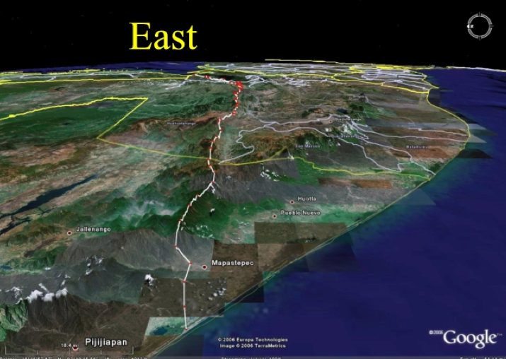
One possible candidate for this strip of wilderness is found along the border between Mexico and Guatemala, which has served as a natural barrier between cultures since before the Spanish conquest.
Don’t be lazy. It may take a little thought and perseverance but you too can do it. After all you don’t have to leave your armchair or your computer screen.
Seriously, if you want to gain an understanding of Book of Mormon geography, you have to do some geographical investigation on your own.
For example:
Look up a scripture in the Book of Mormon that describes a geographical feature. Then write down all the possible ways that scripture could be interpreted in terms of geography and directions. If you only list one possibility, you are relying too much on expert opinion and not thinking it out for your self.
Remember that when Oliver Cowdery wanted to translate and failed he was given the following instruction:
D&C 9:8
But, behold, I say unto you, that you must study it out in your mind; then you must ask me if it be right, and if it is right I will cause that your bosom shall burn within you; therefore, you shall feel that it is right.
Use the 1828 Webster to check your interpretation of the information found in the text and then get out your maps and look for an area or areas in the Americas that fits each of your interpretations. There may be more than one so keep track of all of them so you can determine if they converge with other locations and information.
Don’t be discouraged if it starts to look complicated, it will get simpler the more you learn.
Any ethnohistoric reconstruction I know of attempts to fill in the knowledge gaps with reasonable inferences from cultures or situations that are plausibly parallel. The problem is that the simplistic methodology of creating lists of "parallels" has so muddied the methodological waters that if nothing else, convergence is a term that allows for the preservation of the good without the unfortunate bad baggage of the poor methodologies.
Parallels, in and of themselves, are next to useless. Sometimes the items paralleled are clearly parallel, but the parallels could easily be due to independent invention. One such is the "parallel" of using adobe in the Old and New Worlds. That is certainly parallel - but meaningless. There is nothing inherently unique about sun-dried mud.
Other problems in parallels are that many times "parallels" are created by the way they are described. Things that really have no relationship to one another at all can be made to appear "parallel" if worded correctly. That doesn't make them useful - it makes them deceptive.
The concept of a convergence is much more useful because it understands that there is no single point of comparison that really shows anything. What is required is multiple points of simultaneous and interconnect comparisons. The more you have multiple parallels that are unique and interconnected in non-random ways, the more likely that there really is a connection.
However, even with those kinds of convergences there is a lot required before one can say that two otherwise disconnected cultures share time and space in a meaningful way. My favorite example is an Indonesian (Balinese) Garuda carving I have on my desk. The Garuda is a man-eagle who carries Arjun on his back. He has a man's body but bird wings. Most fascinating to me is that he wears a bird mask that has teeth. In addition, at the back of the toothed beak are two large backward curving teeth. Around the connection of the beak to the face is a beard-fringe. This is visually identical to the buccal mask on Mesoamerican Quetzalcoatl figures.
This is a highly arbitrary connection that cannot rely on nature (what bird has not only teeth, but that kind of dentition?). Nevertheless, it is insufficient to demonstrate connection because I cannot currently connect the images in time. Without knowing that there is a time period when they coexist I can't even begin to posit a relationship.
That is where convergences begin to make our case. In the case of the Garuda I have some convergences, but not enough. Enough to be curious and warrant investigation, but insufficient for a conclusion. I need more.
In the case of the Book of Mormon we require similar convergences. They must be similarly arbitrary, consisting of elements that would not normally be seen in that combination. In addition, however, there are further requirements of time and space. There are so many areas in which the text must converge with the real world that when the convergences in each of those areas continue to amount, there is evidence that there is a connection.
That was the basic thrust of my FAIR presentation. There are a large number of non-arbitrary ways in which the text converges with a time and place. Obviously, some are stronger than others, but the continued mass of data that continue to converge on the same place, timeframe, and culture makes it more difficult to dismiss the case as arbitrary.
Posted 18 September 2006 - 11:22 AM
Thanks Brant.
I asked Brant to insert this brief essay because the purpose for understanding Book of Mormon geography should be to gain better understanding of an important factor, which impacted the Nephites and their interactions with the Lamanites. Its purpose is not to produce a testimony of its truth but to add to and enhance the testimony we already have.
Convergence between geography and the Book of Mormon story as it emerges from the writings of Nephi and his family and the abridgment of Nephite history provided by Mormon is necessary in order for any attempt to define Book of Mormon geography to be useful and/or convincing.
Brant’s statement:
Brant:
The concept of a convergence is much more useful because it understands that there is no single point of comparison {Substitute that geographic feature or location} that really shows anything. What is required is multiple points of simultaneous and interconnect comparisons. The more you have multiple parallels {again substitute geographic feature or location} that are unique and interconnected in non-random ways, the more likely that there really is a connection.
applies to Book of Mormon geography and should always be remembered when reading and interpreting the textual information about geography found in the Book of Mormon.
Larry Poulsen
Posted 19 September 2006 - 03:42 PM
Ground rules and Cautions
Language of translation
Joseph Smith’s culture
Science and geography
Geographic features that change rapidly
Geographic features that change slowly
Artifacts and ruins
Joseph Smith's education, at the time he translated the plates, was in all probability similar to any other youth living on the western frontier. His family had a copy of the Bible and history indicates that he was quite familiar with its content and was able to read it by himself. There is no indication that he or his family owned an extensive library but this does not preclude the possibility that they had other books, possibly those used by local schoolteachers. Although his family may not have been able to afford their own copy of Webster's 1828 dictionary, there is little doubt that he spoke and understood the language, which is reflected in that dictionary.
As reported on the title page of the Book of Mormon, translated from words written by Moroni, the purpose of the book and the matter of the translation were:
Wherefore, it is an abridgment of the record of the people of Nephi, and also of the Lamanites--Written to the Lamanites, who are a remnant of the house of Israel; and also to Jew and Gentile--Written by way of commandment, and also by the spirit of prophecy and of revelation--Written and sealed up, and hid up unto the Lord, that they might not be destroyed--To come forth by the gift and power of God unto the interpretation thereof--Sealed by the hand of Moroni, and hid up unto the Lord, to come forth in due time by way of the Gentile--The interpretation thereof by the gift of God.
To fulfill this purpose the language used in the translation would have to be that of the common people or in other words the language of his peers as reflected in the dictionaries of his day. The interpretation was to be by the gift and power of God and not by the learned men of his day or our day. Even though Joseph Smith may have been limited in knowledge and may not have had an extensive vocabulary outside of that found in the Bible, the Holy Ghost would have ensured that he chose the correct words and usage of his times.
Unfortunately, our culture and the meaning of words has changed over the last 150 years so we must be cautious of imposing modern meanings and words onto the language used by Joseph Smith in his translation of the sacred records.
I will talk more about the culture of the western frontier in Joseph' day when we consider the topic of directions. But for now here is a homework assignment.
At the University of Texas, where I taught and did research until I retired, there is a faculty lounge call "Forty Acres.” In western movies and novels one often finds the authors referring to "The south forty.” Your assignment is to consider these terms, which originated in the western frontier culture of the 19th century and what is their significance with relationship to that culture's view of geography.
Geography is a part of science and includes more than just maps. It is concerned with the relationship between man and his surroundings. Maps are only useful if they enhance or qualify our understanding of the relationship between man, his culture and the environment. Even though it is convenient to propose theories about Book of Mormon geography that invoke major changes in the geography of the American continents, in order to justify a map of our favorite location for the Book of Mormon culture, there is no geological indication that such changes have taken place. Evidence for rapid changes in the surface of the land, such as changes in the course of rivers, new volcanoes, buried cities and minor changes in the location of the seashore relative to the land mass are plentiful but any major rapid shift in the level of the land mass would have been felt around the world and be easily detected in the geological record. Major changes of this nature occur very slowly. When considering locations for the Book of Mormon culture we should be sure it fits into the known areas and time frames where pre-Columbian cultures with the attributes of the Nephites and Lamanites have been shown to exist. This does not preclude the possibility of locating them in an area where we have as yet no information about past cultures but those areas are getting fewer and fewer.
Finally a word about artifacts and ruins. Any attempt to make the geography fit the existence of particular kinds of artifacts or to equate the location of Book of Mormon cities with the locations of particularly fascinating ruins should be highly discouraged. If the map, based only on the text, suggests such a correlation, it might lead to a convergence as more data about Book of Mormon culture and the culture of the area of the ruins and its time frame are brought into play. It should not, however, be the object of the proposed geography to attempt to show that the ruins are part of the Book of Mormon culture
More to come, we just got through chapter two. We have at least four more to go.
Do your homework. Report back what you find if you would like to do so, otherwise I will see you in the discussion section.
Posted 23 September 2006 - 12:17 PM
We are still in chapter 2. One of the major problems of Book of Mormon geographers is the failure to establish ground rules before starting to sort out the many descriptions and references to geography found in the Book of Mormon. Another is the failure to establish the meanings of geographical terms such as sea, up, down and the cardinal directions as used in Joseph Smith's time and culture and/or in pre-Columbian cultures of the Americas. These criteria should be carefully thought out, written down and followed. If not, contradictions will be introduced into the model as a result of introducing new assumptions as you go along.
The following list includes most of, but not all of my assumptions, and the ground rules I feel are important:
From my website.
Getting Things straight
1. Joseph Smith translated the Book of Mormon by divine power and it is the most correct book of scripture that we presently have. This however, does not say it does not contain errors and/or ambiguities in grammar. Both Mormon and Moroni expressed their concern about possible errors. This does not, however, give us license to resolve problems with our interpretation of geography by claiming that they were in error or that Joseph Smith mistranslated that concept.
2. He translated it into the English language based on what he spoke and the use of words and directions with which he was familiar. This is not necessarily the same as what we are accustomed to in our urban culture of today. However, it is a true and correct translation. We must, therefore assume that all directions were translated correctly and did not result from a misunderstanding by Joseph Smith of the Book of Mormon culture in relation to the agrarian culture of upper New York State in the early 1800s.
3. The Book of Mormon is a lineage history, an abridgment of many records recorded (with great difficulty) on a limited number of gold plates and therefore many descriptions of activities described and battles may be more abbreviated and shortened than what we might expect from a contemporary description of similar events. Because of the difficulty in engraving on the plates we must accept the probability that Mormon only included that, which was important and useful to the future reader of his words.
4. We must accept geographical descriptions as carrying more weight in determining relative locations than distances calculated by assuming travel distances based on calculations of the time it took to carry out different and varied activities described in the Book of Mormon. There should be agreement with the type of geography and the nature of the activity, but the size or the distance covered may be greater or less than our assumptions would suggest. However, all areas described should be in the right place with respect to what is said in the text. This may require us to reexamine our preconceived assumptions and their effect on our interpretation of the scriptural text.
5. And finally, we must take great care in attempting to fit our map to areas based on the existence of ruins and our assumptions about their identity to book of Mormon locations.
6. We must, however, base our assumptions on the known data concerning the cultures of Mesoamerica, the times these cultures existed and the geographic areas they occupied. The Jaredite culture must exist at a time with literate cultures known to have existed no earlier than 3000 B.C. and which essentially disappeared shortly before the birth of Christ. The Olmec culture is generally accepted to have existed during this time. We could, of course, assume a very limited area where little or no data is available and propose anything that pleases. This is inconsistent with population descriptions and statements in the Book of Mormon about the extent to which the lands were occupied. It is unreasonable to think that Joseph Smith would have inaccurately translated these concepts. The Olmec culture occupied the lowland areas on the Atlantic coast from Veracruz on the west to Villahermosa on the east. Although it is tempting to equate the Jaredites with the Olmec culture, care should be taken in doing so. Recent evidence has shown that cultures similar to the Olmecs and in the same time period have been found in the area near Tampico far from the Olmec heartland. On the other hand, the Nephite culture ended before 600 A.D. and cannot be equated with either the Aztec or Inca cultures which did not arise until after 1000 A.D. The Nephite culture is difficult to identify, because it coexisted with the Lamanite culture which, as reported in the Book of Mormon, was always more numerous than the Nephites and did not disappear at the same time as the Nephite culture. In fact it may have flourished after the destruction of their archrivals, the Nephites.
These are my criteria; you need to establish your own set.
We will discuss the meaning of geographic terms in the next installment.
Remember your homework assignment. I have not seen any thoughts on this question here {Where are all the pundits?} or in the discussion thread.
Larry Poulsen
Posted 23 September 2006 - 02:24 PM
Charity sent the following information (homework) to me by PM. Since it is highly pertinent to our understanding of geographic culture in the time of Joseph Smith, I obtained permission to post it here as part of the main thread.
Charity:
Various versions of free land acts, such as the Homestead Act of 1862 gave individuals or heads of households quarter-sections of land, which were approximately 160 acres. Farmers would divide up their 160 acres into sections, and designate them by directions, n, e, w, s. These did not have to be necessarily 40 acres exactly.
Also, the term "forty" per the 1828 Webster’s could mean an indefinite number.
The land areas were surveyed into large tracts determined by government surveyors. Out here in Oregon, all the surveys start from the intersection of the Willamette Meridian and Willamette Baseline. The Land Act of 1850 occasioned the placing of the marker, at first just a cedar stake, which has since been replaced by a metal marker.
Thanks, Charity, for your input.
Now, which section is the "south forty"?
Larry Poulsen
Posted 29 September 2006 - 09:45 PM
We are now approaching that aspect of Book of Mormon Geography that has produced a fair amount of controversy. It is not the purpose of this exercise to resolve these controversies, however, I will try to point out the tools available to each of you that you may come to your own conclusions. I will of course at times inject by own bias. After all that is one prerogative of the teacher.
Before actually considering the meanings of the geographic terms found in the text of the Book of Mormon, please consider the following.
In the following,
D&C 1:24
Behold, I am God and have spoken it; these commandments are of me, and were given unto my servants in their weakness, after the manner of their language, that they might come to understanding.
we are given to understand that God, because of men's weakness, gives His revelations to His servants in the manner of their language so that they will understand and be able to transmit his message to us.
In the following:
D&C 1:29
And after having received the record of the Nephites, yea, even my servant Joseph Smith, Jun., might have power to translate through the mercy of God, by the power of God, the Book of Mormon.
we learn that this applies to the translation of the Book of Mormon.
Years ago I attended a General Priesthood meeting in Salt Lake City where a professor of communication was asked to talk on the manner in which we communicate with each other. The only thing that has stuck with me from his talk was his statement, which I can only paraphrase as follows:
When I speak to you, I speak from the background of my experience (and culture) When you listen to me you understand based on the background of your experience (and culture). Communication only occurs when we have a common background and experience.
When reading the Book of Mormon, most of us have little trouble understanding the spiritual messages because we tend to have a common background based on the Bible and a culture founded on Christian principles. When it comes to understanding non-religious concepts found in the Book of Mormon such as geography, we are faced with the fact that we do not have a common background, with respect to geography, with the culture and writers of the Book of Mormon peoples.
When we are faced with this problem in communication between two people, both speakers have a responsibility to at least attempt to acquire some knowledge about each other’s background and experience and stick to topics where there is a common background and experience until understanding creates new areas of common experience.
In the case of the Book of Mormon, we do not have the option of expecting the writers of the Book of Mormon to understand and relate to our background and experience, although they certainly tried to do so through revelation and the power of the Holy Ghost. It is incumbent on us as individuals to seek after knowledge and understanding of their culture and background and not try to interpret their geographic descriptions based on our knowledge and background about geography.
Fortunately for us, as noted above, Joseph Smith was chosen to translate the Book of Mormon into the English language for our understanding and did so by the mercy and power of God.
Unfortunately for us, the translation was done into Joseph Smith's understanding of the English language and culture of his day and this has changed significantly in many ways since that time.
Fortunately we have available dictionaries published during Joseph Smith's lifetime, which reflect the culture and language of his day and provide us a way to learn about and become acquainted with the language used to translate the Book of Mormon.
Your next exercise is to look up the following words in the 1828 Webster and ponder how they might differ in meaning from the meaning given to them in our modern urban culture. Don’t just look at the first meaning given. Also check some of the other words that use the word in its definition. This will give you more of a feeling of how the word was used in Joseph Smith's time and culture.
North, South, East, West, up, down, hill, sea, lake, mountain, wilderness, northward, eastward, southward, and westward.
For those of you who are too lazy to look them up yourselves, I will publish them with my comments in the next installment.
Larry Poulsen
Definitions
Let's start with wilderness:
From 1828 Webster
WILDERNESS, n. [from wild.]
1. A desert; a tract of land or region uncultivated and uninhabited by human beings, whether a forest or a wide barren plain. In the United States, it is applied only to a forest. In Scripture, it is applied frequently to the deserts of Arabia. The Israelites wandered in the wilderness forty years.
DESOLATE, a.
1. Destitute or deprived of inhabitants; desert; uninhabited; denoting either stripped of inhabitants, or never having been inhabited; as a desolate isle; a desolate wilderness.
In the United States at this time the word wilderness was never applied to an arid location but denoted an uninhabited area. In the Book of Mormon in Alma we find a description of a wilderness, which separates the Land of Zarahemla (Nephites) to the north from the Land of Nephi-Lehi (Lamanites) to the south.
Alma 22:27 And it came to pass that the king sent a (a)proclamation throughout all the land, amongst all his people who were in all his land, who were in all the regions round about, which was bordering even to the sea, on the east and on the (b)west, and which was divided from the land of (c)Zarahemla by a narrow strip of wilderness, which ran from the sea east even to the sea west, and round about on the borders of the seashore, and the borders of the wilderness which was on the north by the land of Zarahemla, through the borders of (d)Manti, by the head of the (e)River Sidon, running from the east towards the west and thus were the Lamanites and the Nephites divided.
It is described as a "narrow strip" and runs from the east sea to the west sea. It contains the headwaters of the river Sidon and therefore must be at a higher elevation than the Land of Zarahemla. Other scriptures indicate that it was necessary to go "up" to reach the head of the Sidon. These requirements suggest a narrow strip of mountains, sparsely or uninhabited which formed a natural barrier between the Nephite and Lamanite lands.
One possible candidate for this strip of wilderness is found along the border between Mexico and Guatemala, which has served as a natural barrier between cultures since before the Spanish conquest.Don’t be lazy. It may take a little thought and perseverance but you too can do it. After all you don’t have to leave your armchair or your computer screen.
More to come but you have enough info to get started.
Larry Poulsen
Posted 17 September 2006 - 12:53 PM
Seriously, if you want to gain an understanding of Book of Mormon geography, you have to do some geographical investigation on your own.
For example:
Look up a scripture in the Book of Mormon that describes a geographical feature. Then write down all the possible ways that scripture could be interpreted in terms of geography and directions. If you only list one possibility, you are relying too much on expert opinion and not thinking it out for your self.
Remember that when Oliver Cowdery wanted to translate and failed he was given the following instruction:
D&C 9:8
But, behold, I say unto you, that you must study it out in your mind; then you must ask me if it be right, and if it is right I will cause that your bosom shall burn within you; therefore, you shall feel that it is right.
Use the 1828 Webster to check your interpretation of the information found in the text and then get out your maps and look for an area or areas in the Americas that fits each of your interpretations. There may be more than one so keep track of all of them so you can determine if they converge with other locations and information.
Don’t be discouraged if it starts to look complicated, it will get simpler the more you learn.
One of the ways you can progress is to ask questions. I will try to answer some of them as we go along.
So I will expect to see a regular report on your Homework. I won’t correct it but maybe someone else will try to correct it for you.
Larry Poulsen
Posted 17 September 2006 - 10:27 PM
I would be particularly interested in a short essay on the difference between convergence and parallels.
Any ethnohistoric reconstruction I know of attempts to fill in the knowledge gaps with reasonable inferences from cultures or situations that are plausibly parallel. The problem is that the simplistic methodology of creating lists of "parallels" has so muddied the methodological waters that if nothing else, convergence is a term that allows for the preservation of the good without the unfortunate bad baggage of the poor methodologies.
Parallels, in and of themselves, are next to useless. Sometimes the items paralleled are clearly parallel, but the parallels could easily be due to independent invention. One such is the "parallel" of using adobe in the Old and New Worlds. That is certainly parallel - but meaningless. There is nothing inherently unique about sun-dried mud.
Other problems in parallels are that many times "parallels" are created by the way they are described. Things that really have no relationship to one another at all can be made to appear "parallel" if worded correctly. That doesn't make them useful - it makes them deceptive.
The concept of a convergence is much more useful because it understands that there is no single point of comparison that really shows anything. What is required is multiple points of simultaneous and interconnect comparisons. The more you have multiple parallels that are unique and interconnected in non-random ways, the more likely that there really is a connection.
However, even with those kinds of convergences there is a lot required before one can say that two otherwise disconnected cultures share time and space in a meaningful way. My favorite example is an Indonesian (Balinese) Garuda carving I have on my desk. The Garuda is a man-eagle who carries Arjun on his back. He has a man's body but bird wings. Most fascinating to me is that he wears a bird mask that has teeth. In addition, at the back of the toothed beak are two large backward curving teeth. Around the connection of the beak to the face is a beard-fringe. This is visually identical to the buccal mask on Mesoamerican Quetzalcoatl figures.
This is a highly arbitrary connection that cannot rely on nature (what bird has not only teeth, but that kind of dentition?). Nevertheless, it is insufficient to demonstrate connection because I cannot currently connect the images in time. Without knowing that there is a time period when they coexist I can't even begin to posit a relationship.
That is where convergences begin to make our case. In the case of the Garuda I have some convergences, but not enough. Enough to be curious and warrant investigation, but insufficient for a conclusion. I need more.
In the case of the Book of Mormon we require similar convergences. They must be similarly arbitrary, consisting of elements that would not normally be seen in that combination. In addition, however, there are further requirements of time and space. There are so many areas in which the text must converge with the real world that when the convergences in each of those areas continue to amount, there is evidence that there is a connection.
That was the basic thrust of my FAIR presentation. There are a large number of non-arbitrary ways in which the text converges with a time and place. Obviously, some are stronger than others, but the continued mass of data that continue to converge on the same place, timeframe, and culture makes it more difficult to dismiss the case as arbitrary.
Posted 18 September 2006 - 11:22 AM
Thanks Brant.
I asked Brant to insert this brief essay because the purpose for understanding Book of Mormon geography should be to gain better understanding of an important factor, which impacted the Nephites and their interactions with the Lamanites. Its purpose is not to produce a testimony of its truth but to add to and enhance the testimony we already have.
Convergence between geography and the Book of Mormon story as it emerges from the writings of Nephi and his family and the abridgment of Nephite history provided by Mormon is necessary in order for any attempt to define Book of Mormon geography to be useful and/or convincing.
Brant’s statement:
Brant:
The concept of a convergence is much more useful because it understands that there is no single point of comparison {Substitute that geographic feature or location} that really shows anything. What is required is multiple points of simultaneous and interconnect comparisons. The more you have multiple parallels {again substitute geographic feature or location} that are unique and interconnected in non-random ways, the more likely that there really is a connection.
applies to Book of Mormon geography and should always be remembered when reading and interpreting the textual information about geography found in the Book of Mormon.
Larry Poulsen
Posted 19 September 2006 - 03:42 PM
Ground rules and Cautions
Language of translation
Joseph Smith’s culture
Science and geography
Geographic features that change rapidly
Geographic features that change slowly
Artifacts and ruins
Joseph Smith's education, at the time he translated the plates, was in all probability similar to any other youth living on the western frontier. His family had a copy of the Bible and history indicates that he was quite familiar with its content and was able to read it by himself. There is no indication that he or his family owned an extensive library but this does not preclude the possibility that they had other books, possibly those used by local schoolteachers. Although his family may not have been able to afford their own copy of Webster's 1828 dictionary, there is little doubt that he spoke and understood the language, which is reflected in that dictionary.
As reported on the title page of the Book of Mormon, translated from words written by Moroni, the purpose of the book and the matter of the translation were:
Wherefore, it is an abridgment of the record of the people of Nephi, and also of the Lamanites--Written to the Lamanites, who are a remnant of the house of Israel; and also to Jew and Gentile--Written by way of commandment, and also by the spirit of prophecy and of revelation--Written and sealed up, and hid up unto the Lord, that they might not be destroyed--To come forth by the gift and power of God unto the interpretation thereof--Sealed by the hand of Moroni, and hid up unto the Lord, to come forth in due time by way of the Gentile--The interpretation thereof by the gift of God.
To fulfill this purpose the language used in the translation would have to be that of the common people or in other words the language of his peers as reflected in the dictionaries of his day. The interpretation was to be by the gift and power of God and not by the learned men of his day or our day. Even though Joseph Smith may have been limited in knowledge and may not have had an extensive vocabulary outside of that found in the Bible, the Holy Ghost would have ensured that he chose the correct words and usage of his times.
Unfortunately, our culture and the meaning of words has changed over the last 150 years so we must be cautious of imposing modern meanings and words onto the language used by Joseph Smith in his translation of the sacred records.
I will talk more about the culture of the western frontier in Joseph' day when we consider the topic of directions. But for now here is a homework assignment.
At the University of Texas, where I taught and did research until I retired, there is a faculty lounge call "Forty Acres.” In western movies and novels one often finds the authors referring to "The south forty.” Your assignment is to consider these terms, which originated in the western frontier culture of the 19th century and what is their significance with relationship to that culture's view of geography.
Geography is a part of science and includes more than just maps. It is concerned with the relationship between man and his surroundings. Maps are only useful if they enhance or qualify our understanding of the relationship between man, his culture and the environment. Even though it is convenient to propose theories about Book of Mormon geography that invoke major changes in the geography of the American continents, in order to justify a map of our favorite location for the Book of Mormon culture, there is no geological indication that such changes have taken place. Evidence for rapid changes in the surface of the land, such as changes in the course of rivers, new volcanoes, buried cities and minor changes in the location of the seashore relative to the land mass are plentiful but any major rapid shift in the level of the land mass would have been felt around the world and be easily detected in the geological record. Major changes of this nature occur very slowly. When considering locations for the Book of Mormon culture we should be sure it fits into the known areas and time frames where pre-Columbian cultures with the attributes of the Nephites and Lamanites have been shown to exist. This does not preclude the possibility of locating them in an area where we have as yet no information about past cultures but those areas are getting fewer and fewer.
Finally a word about artifacts and ruins. Any attempt to make the geography fit the existence of particular kinds of artifacts or to equate the location of Book of Mormon cities with the locations of particularly fascinating ruins should be highly discouraged. If the map, based only on the text, suggests such a correlation, it might lead to a convergence as more data about Book of Mormon culture and the culture of the area of the ruins and its time frame are brought into play. It should not, however, be the object of the proposed geography to attempt to show that the ruins are part of the Book of Mormon culture
More to come, we just got through chapter two. We have at least four more to go.
Do your homework. Report back what you find if you would like to do so, otherwise I will see you in the discussion section.
Posted 23 September 2006 - 12:17 PM
We are still in chapter 2. One of the major problems of Book of Mormon geographers is the failure to establish ground rules before starting to sort out the many descriptions and references to geography found in the Book of Mormon. Another is the failure to establish the meanings of geographical terms such as sea, up, down and the cardinal directions as used in Joseph Smith's time and culture and/or in pre-Columbian cultures of the Americas. These criteria should be carefully thought out, written down and followed. If not, contradictions will be introduced into the model as a result of introducing new assumptions as you go along.
The following list includes most of, but not all of my assumptions, and the ground rules I feel are important:
From my website.
Getting Things straight
1. Joseph Smith translated the Book of Mormon by divine power and it is the most correct book of scripture that we presently have. This however, does not say it does not contain errors and/or ambiguities in grammar. Both Mormon and Moroni expressed their concern about possible errors. This does not, however, give us license to resolve problems with our interpretation of geography by claiming that they were in error or that Joseph Smith mistranslated that concept.
2. He translated it into the English language based on what he spoke and the use of words and directions with which he was familiar. This is not necessarily the same as what we are accustomed to in our urban culture of today. However, it is a true and correct translation. We must, therefore assume that all directions were translated correctly and did not result from a misunderstanding by Joseph Smith of the Book of Mormon culture in relation to the agrarian culture of upper New York State in the early 1800s.
3. The Book of Mormon is a lineage history, an abridgment of many records recorded (with great difficulty) on a limited number of gold plates and therefore many descriptions of activities described and battles may be more abbreviated and shortened than what we might expect from a contemporary description of similar events. Because of the difficulty in engraving on the plates we must accept the probability that Mormon only included that, which was important and useful to the future reader of his words.
4. We must accept geographical descriptions as carrying more weight in determining relative locations than distances calculated by assuming travel distances based on calculations of the time it took to carry out different and varied activities described in the Book of Mormon. There should be agreement with the type of geography and the nature of the activity, but the size or the distance covered may be greater or less than our assumptions would suggest. However, all areas described should be in the right place with respect to what is said in the text. This may require us to reexamine our preconceived assumptions and their effect on our interpretation of the scriptural text.
5. And finally, we must take great care in attempting to fit our map to areas based on the existence of ruins and our assumptions about their identity to book of Mormon locations.
6. We must, however, base our assumptions on the known data concerning the cultures of Mesoamerica, the times these cultures existed and the geographic areas they occupied. The Jaredite culture must exist at a time with literate cultures known to have existed no earlier than 3000 B.C. and which essentially disappeared shortly before the birth of Christ. The Olmec culture is generally accepted to have existed during this time. We could, of course, assume a very limited area where little or no data is available and propose anything that pleases. This is inconsistent with population descriptions and statements in the Book of Mormon about the extent to which the lands were occupied. It is unreasonable to think that Joseph Smith would have inaccurately translated these concepts. The Olmec culture occupied the lowland areas on the Atlantic coast from Veracruz on the west to Villahermosa on the east. Although it is tempting to equate the Jaredites with the Olmec culture, care should be taken in doing so. Recent evidence has shown that cultures similar to the Olmecs and in the same time period have been found in the area near Tampico far from the Olmec heartland. On the other hand, the Nephite culture ended before 600 A.D. and cannot be equated with either the Aztec or Inca cultures which did not arise until after 1000 A.D. The Nephite culture is difficult to identify, because it coexisted with the Lamanite culture which, as reported in the Book of Mormon, was always more numerous than the Nephites and did not disappear at the same time as the Nephite culture. In fact it may have flourished after the destruction of their archrivals, the Nephites.
These are my criteria; you need to establish your own set.
We will discuss the meaning of geographic terms in the next installment.
Remember your homework assignment. I have not seen any thoughts on this question here {Where are all the pundits?} or in the discussion thread.
Larry Poulsen
Posted 23 September 2006 - 02:24 PM
Charity sent the following information (homework) to me by PM. Since it is highly pertinent to our understanding of geographic culture in the time of Joseph Smith, I obtained permission to post it here as part of the main thread.
Charity:
Various versions of free land acts, such as the Homestead Act of 1862 gave individuals or heads of households quarter-sections of land, which were approximately 160 acres. Farmers would divide up their 160 acres into sections, and designate them by directions, n, e, w, s. These did not have to be necessarily 40 acres exactly.
Also, the term "forty" per the 1828 Webster’s could mean an indefinite number.
The land areas were surveyed into large tracts determined by government surveyors. Out here in Oregon, all the surveys start from the intersection of the Willamette Meridian and Willamette Baseline. The Land Act of 1850 occasioned the placing of the marker, at first just a cedar stake, which has since been replaced by a metal marker.
Thanks, Charity, for your input.
Now, which section is the "south forty"?
Larry Poulsen
Posted 29 September 2006 - 09:45 PM
We are now approaching that aspect of Book of Mormon Geography that has produced a fair amount of controversy. It is not the purpose of this exercise to resolve these controversies, however, I will try to point out the tools available to each of you that you may come to your own conclusions. I will of course at times inject by own bias. After all that is one prerogative of the teacher.
Before actually considering the meanings of the geographic terms found in the text of the Book of Mormon, please consider the following.
In the following,
D&C 1:24
Behold, I am God and have spoken it; these commandments are of me, and were given unto my servants in their weakness, after the manner of their language, that they might come to understanding.
we are given to understand that God, because of men's weakness, gives His revelations to His servants in the manner of their language so that they will understand and be able to transmit his message to us.
In the following:
D&C 1:29
And after having received the record of the Nephites, yea, even my servant Joseph Smith, Jun., might have power to translate through the mercy of God, by the power of God, the Book of Mormon.
we learn that this applies to the translation of the Book of Mormon.
Years ago I attended a General Priesthood meeting in Salt Lake City where a professor of communication was asked to talk on the manner in which we communicate with each other. The only thing that has stuck with me from his talk was his statement, which I can only paraphrase as follows:
When I speak to you, I speak from the background of my experience (and culture) When you listen to me you understand based on the background of your experience (and culture). Communication only occurs when we have a common background and experience.
When reading the Book of Mormon, most of us have little trouble understanding the spiritual messages because we tend to have a common background based on the Bible and a culture founded on Christian principles. When it comes to understanding non-religious concepts found in the Book of Mormon such as geography, we are faced with the fact that we do not have a common background, with respect to geography, with the culture and writers of the Book of Mormon peoples.
When we are faced with this problem in communication between two people, both speakers have a responsibility to at least attempt to acquire some knowledge about each other’s background and experience and stick to topics where there is a common background and experience until understanding creates new areas of common experience.
In the case of the Book of Mormon, we do not have the option of expecting the writers of the Book of Mormon to understand and relate to our background and experience, although they certainly tried to do so through revelation and the power of the Holy Ghost. It is incumbent on us as individuals to seek after knowledge and understanding of their culture and background and not try to interpret their geographic descriptions based on our knowledge and background about geography.
Fortunately for us, as noted above, Joseph Smith was chosen to translate the Book of Mormon into the English language for our understanding and did so by the mercy and power of God.
Unfortunately for us, the translation was done into Joseph Smith's understanding of the English language and culture of his day and this has changed significantly in many ways since that time.
Fortunately we have available dictionaries published during Joseph Smith's lifetime, which reflect the culture and language of his day and provide us a way to learn about and become acquainted with the language used to translate the Book of Mormon.
Your next exercise is to look up the following words in the 1828 Webster and ponder how they might differ in meaning from the meaning given to them in our modern urban culture. Don’t just look at the first meaning given. Also check some of the other words that use the word in its definition. This will give you more of a feeling of how the word was used in Joseph Smith's time and culture.
North, South, East, West, up, down, hill, sea, lake, mountain, wilderness, northward, eastward, southward, and westward.
For those of you who are too lazy to look them up yourselves, I will publish them with my comments in the next installment.
Larry Poulsen
Definitions
Let's start with wilderness:
From 1828 Webster
WILDERNESS, n. [from wild.]
1. A desert; a tract of land or region uncultivated and uninhabited by human beings, whether a forest or a wide barren plain. In the United States, it is applied only to a forest. In Scripture, it is applied frequently to the deserts of Arabia. The Israelites wandered in the wilderness forty years.
DESOLATE, a.
1. Destitute or deprived of inhabitants; desert; uninhabited; denoting either stripped of inhabitants, or never having been inhabited; as a desolate isle; a desolate wilderness.
In the United States at this time the word wilderness was never applied to an arid location but denoted an uninhabited area. In the Book of Mormon in Alma we find a description of a wilderness, which separates the Land of Zarahemla (Nephites) to the north from the Land of Nephi-Lehi (Lamanites) to the south.
Alma 22:27 And it came to pass that the king sent a (a)proclamation throughout all the land, amongst all his people who were in all his land, who were in all the regions round about, which was bordering even to the sea, on the east and on the (b)west, and which was divided from the land of (c)Zarahemla by a narrow strip of wilderness, which ran from the sea east even to the sea west, and round about on the borders of the seashore, and the borders of the wilderness which was on the north by the land of Zarahemla, through the borders of (d)Manti, by the head of the (e)River Sidon, running from the east towards the west and thus were the Lamanites and the Nephites divided.
It is described as a "narrow strip" and runs from the east sea to the west sea. It contains the headwaters of the river Sidon and therefore must be at a higher elevation than the Land of Zarahemla. Other scriptures indicate that it was necessary to go "up" to reach the head of the Sidon. These requirements suggest a narrow strip of mountains, sparsely or uninhabited which formed a natural barrier between the Nephite and Lamanite lands.
One possible candidate for this strip of wilderness is found along the border between Mexico and Guatemala, which has served as a natural barrier between cultures since before the Spanish conquest.
This is my primary choice. There may be others but you can look for yourselves.
More definitions to come.
Larry Poulsen
More definitions
Sea, lake and ocean
SEA, n. see. [This word, like lake, signifies primarily a seat, set or lay, a repository, a bason.]
2. A large body of water, nearly enclosed by land, as the Baltic or the Mediterranean; as the sea of Azof. Seas are properly branches of the ocean, and upon the same level. Large bodies of water inland, and situated above the level of the ocean, are lakes. The appellation of sea, given to the Caspian lake, is an exception, and not very correct. So the lake of Galilee is called a sea, from the Greek.
3. The ocean; as, to go to sea. The fleet is at sea, or on the high seas.
LAKE, n. [L. lacus. A lake is a stand of water, from the root of lay. Hence L. lagena, Eng. flagon.]
1. A large and extensive collection of water contained in a cavity or hollow of the earth. It differs from a pond in size, the latter being a collection of small extent; but sometimes a collection of water is called a pond or a lake indifferently. North America contains some of the largest lakes on the globe, particularly the lakes Ontario, Erie, Huron, Michigan and Superior.
OCEAN, n. o'shun. [L. oceanus; Gr.; Heb. to encompass, whence a circle. This is probably an error. The word seems to have for its origin greatness or extent.]
1. The vast body of water which covers more than three fifths of the surface of the globe, called also the sea, or great sea. It is customary to speak of the ocean as if divided into three parts, the Atlantic ocean, the Pacific ocean, and the Indian ocean; but the ocean is one mass or body, partially separated by the continents of Europe, Asia and Africa on one side, and by America on the other.
2. An immense expanse; as the boundless ocean of eternity; oceans of duration and space.
Keven Barney’s meanings in Hebrew:
"Sea" is *yam*.
"Ocean" is probably *tehom rabbah*, literally "a great
quantity of waters."
In classical Hebrew I'm not aware of a clear
distinction between "lake" and "sea"; a "lake" would
similarly be *yam*. (For instance, the "Sea of
Galilee" is also called "Lake Gennesaret.")
The meaning of these words in Hebrew as opposed to the meaning understood by Joseph Smith's contemporaries brings up the question of whether it is legitimate to substitute lake for the word sea in the Book of Mormon. An example of the use of lake in the Book of Mormon is found in:
Alma 14:14
Now it came to pass that when the bodies of those who had been cast into the fire were consumed, and also the records which were cast in with them, the chief judge of the land came and stood before Alma and Amulek, as they were bound; and he smote them with his hand upon their cheeks, and said unto them: After what ye have seen, will ye preach again unto this people, that they shall be cast into a lake of fire and brimstone?
In the Book of Mormon, lake appears only in the phrase "a lake of fire and brimstone" and nowhere else.
If the underlying text did not distinguish between lake and sea as in the Hebrew language, then it is surprising that Joseph Smith did not use both lake and sea to randomly translate this concept into the English language.
If, however, we accept that the translation was done by divine power and for our understanding today, then his exclusive use of sea would indicate that whatever word Nephi and Mormon used, it referred to a sea rather than a lake. However you can decide for yourselves on this one. Just remember the Book of Mormon was translated to be understandable by the common reader not for students of classical Hebrew.
Interestingly enough, is the manner in which Hebrew expresses the concept of ocean. It is described as "a great quantity of water" exactly as Nephi describes it in
1Nephi 17:5
And we did come to the land which we called (a)Bountiful, because of its much fruit and also wild honey; and all these things were prepared of the Lord that we might not perish. And we beheld the sea, which we called Irreantum, which, being interpreted is many waters.
When I was on my mission in Mexico, I had a companion who was a native speaker of the Nahuatl language. I asked him how the natives would say ocean? His response was "alarge place filled with water.” Apparently, like the Hebrews they had no word for ocean.
Compass directions:
These have been pretty thoroughly discussed in the discussion section, so I will only summarize and post the data from the Book of Mormon text.
The following table shows the distribution and use of directional elements in the text of the Book of Mormon.
North 37
Land North 4
Land on the North 0
In the North 4
In the land North 3
On the North 11
On the land North 0
Northward 45
Land Northward 30
Land on the Northward 1
In the Northward 0
In the land Northward 7
On the Northward 3
On the land Northward 1
South 36
Land South 4
Land on the South 1
In The South 3
In the land South 3
On the South 15
On the land South 0
Southward 20
Land Southward 14
Land on the Southward 1
In the Southward 0
In the land Southward 4
On the Southward 2
On the Land Southward 1
East 47
Land East 0
Land on the East 0
In the East 4
In the land East 0
On the East 17
On the land East 0
Eastward 3
Land Eastward 0
Land on the Eastward 0
In the Eastward 0
In the land Eastward 0
On the eastward 0
On the land Eastward 0
West 41
Land West 0
Land on the West 0
In the west 2
In the land West 0
On the West 18
On the land west 0
Westward 0
Land Westward 0
Land on the Westward 0
In the Westward 0
In the land Westward 0
On the Westward 0
On the land Westward 0
As you can see, there are more references to directions containing the elements of north and south than to those containing east and west. There are no references to westward and only three to eastward.
Based on the following vectorial distribution of directions expected from the Mesoamerican concept of directions:
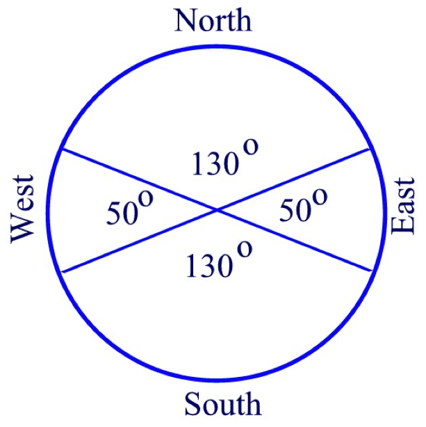
The calculated distributions are northern quarter 39%, eastern quarter 19%, western quarter 16 %, southern quarter 27%. The theoretical distribution is 37%, 13%, 13%, and 37% respectively. Not a perfect match but much better than the 25% for all quarters expected from our modern concept of equal distribution to the four quarters based on the compass rose.
Although this supports a Mesoamerican location for the Book of Mormon culture it does not prove it. Any location from about latitude 30 degrees north to 30 degrees south would have a similar distribution for cultures that used the solstice positions of sunrise. However, as one approaches latitudes of 45 degrees the angle between the winter and the summer sunset at the solstice approaches 90 degrees and a 25% distribution for each quarter.
Your final tool
If one draws the above vectorial distribution pattern on a transparent plastic sheet, one can move it over a map and center it on rivers running south to north. Only those rivers that show seas, or large bodies of water in all four quarters or at a minimum in the eastern and western quarters are viable candidates for the river Sidon and thus the central parts of the Nephite lands.
Larry Poulsen
Now that you have all the basic tools you need to study the geographic texts of the Book of Mormon and build your own concept of Book of Mormon geography, it is time to look at methods.
In order to build a consistent picture of any geography from textual descriptions, it is necessary to already have or choose an anchor point. This geographic feature serves as the anchor around which all other geographic features mentioned in the text are placed. The text must contain descriptive information sufficient to identify a location on modern maps, which fits the description in the text.
Both Jerusalem and the Red Sea are old world locations mentioned in the Book of Mormon. Since Jerusalem is the point of departure for Lehi and his family, it is the obvious choice for an anchor point for their travels in the old world from Jerusalem to the seashore at Bountiful. It has a continuous historical context from the time Lehi left Jerusalem up to our day and there is no problem locating it on modern maps. Using Jerusalem and the geography of the surrounding area a reasonable description of this part of the journey has been proposed. It fits both the culture and the geography as described in the text of the Book of Mormon.
When we consider the new world of the Americas we are faced with the problem that there are no geographical features mentioned in the text that have a continuous historical context going back to the time of Lehi and his family's arrival in the new world. The only connection we have is the final burial place of the plates. Although we know where Joseph Smith found them, there is no textual information connecting that place with any other geographical feature mentioned in the Book of Mormon. During the 35 years that Moroni wandered before burying the plates, he could have traveled from almost any place in the Americas to the hill in New York where he buried the plates and later delivered them to Joseph Smith. It is unlikely that he remained in the same area where the last battles were fought since in his own words, he was fleeing from the Lamanites who obviously still controlled that area.
Since Joseph Smith and the early saints were of the opinion that Zarahemla was located somewhere in Central America or southern Mexico then if we identify the hill in New York with the Hill Cumorah of the Book of Mormon, which the early Latter-day Saints did, we are faced with the problem of resolving the numerous travel times mentioned in the text between locations near Zarahemla and the Land of Cumorah. There is, however, no problem with accepting that Moroni could have traveled from there to New York in 35 years. Since there are many other geographic features mentioned in the text that are not plagued by this problem, it is reasonable to put the location of the Book of Mormon Hill Cumorah on the back burner until we have a better idea of where we think the Book Mormon culture took place. We can then try to identify possible locations for this feature.
Not having good evidence to identify the Book of Mormon Cumorah as an anchor we must choose another. Possibilities are
The narrow neck
The narrow strip of wilderness
The east sea
The west sea
and
The river Sidon.
If we base our choice on the number of times the feature is mentioned and the amount of geographical information available in the text then the order of preference is as follows
1. The river Sidon
2. The east sea and west sea
3. The narrow neck
4. The narrow strip of wilderness
No other feature is mentioned with as much geographic information as for the river Sidon. Although the seas are mentioned numerous times, the only information about them is their direction with respect to the principle parts of the land of Zarahemla. The narrow neck, both seas and the narrow strip of wilderness are all mentioned with their geographical relationship to the Head of the river Sidon. If we choose the river Sidon as anchor, then the relationship between these features and the river Sidon as described in the text will serve to ensure we have chosen a river on modern maps with a high probability of being the same as the river Sidon described in the text of the Book of Mormon. Any rivers that do not place these features in the correct relationship to the Sidon are poor candidates and will result in a high probability that the chosen location is wrong.
One final caveat. Although there have been many proposed internal maps of Book of Mormon geography, most of them fail to correlate
well with real geography. Geological, archeological and anthropological data all agree that, other than minor changes due to volcanic activity and earthquakes, the geography of the Americas has seen little change since well before the arrival of Book of Mormon peoples on the American continent. In order to create a rational concept of Book of Mormon geography requires a constant back and forth examination of the text and the geography using the best maps available to us today
You now have sufficient basic tools and information to study the scriptural references in the text, compare it to your map and draw your own conclusions about where the Book of Mormon took place.
For those who wish to know my results using these tools and methods you may visit my Web page titled "Lawrence Poulsen's Book of Mormon Geography". If you don’t already know the URL, PM me and I will send it to you.
Speaking to Oliver Cowdery in
D&C 9:7 the Lord says the following:
7 Behold, you have not understood; you have supposed that I would give it unto you, when you took no thought save it was to ask me.
Oliver was admonished by the Lord concerning why he was unable to translate the Book of Mormon plates. This is sound advice for all of us when it comes to Book of Mormon geography. We might rephrase it as follows:
Behold, you have not understood; you have supposed that I would give it to mine apostles and prophets and they would give it unto thee when you took no thought save it was to ask their opinion.
We have four sources to consider when addressing the topic of Book of Mormon geography. They are:
First and foremost is the English text of the Book of Mormon given to us by the gift and power of God. It contains the words of the Book of Mormon Prophets, first hand witnesses to the geography and sustained as canonized scripture.
Second are the words and statements of Joseph Smith who was instructed directly by Moroni son of Mormon and one of the Nephite prophets.
Third are statements of general authorities and other Church leaders expressing their understanding of the topic.
And forth, not to be ignored are the scientific findings of archeologists, geologists, anthropologists and linguists.
It is to be expected that among these sources, there will be some disagreement but if we study it out as admonished in the above scripture, most of them will disappear and will lead to a better understanding of the topic as a whole.
As a starting point for the study of Book of Mormon geography, I would like to submit the following brief description of some of the methodology involved.
In order to build a consistent picture of any geography from textual descriptions, it is necessary to already have or choose an anchor point. This geographic feature serves as the anchor around which all other geographic features mentioned in the text are placed. The text must contain descriptive information sufficient to identify a location on modern maps, which fits the description in the text.
Both Jerusalem and the Red Sea are old world locations mentioned in the Book of Mormon. Since Jerusalem is the point of departure for Lehi and his family, it is the obvious choice for an anchor point for their travels in the old world from Jerusalem to the seashore at Bountiful. It has a continuous historical context from the time Lehi left Jerusalem up to our day and there is no problem locating it on modern maps. Using Jerusalem and the geography of the surrounding area a reasonable description of this part of the journey has been proposed. It fits both the culture and the geography as described in the text of the Book of Mormon.
When we consider the new world of the Americas we are faced with the problem that there are no geographical features mentioned in the text that have a continuous historical context going back to the time of Lehi and his family's arrival in the new world. The only connection we have is the final burial place of the plates. Although we know where Joseph Smith found them, there is no textual information connecting that place with any other geographical feature mentioned in the Book of Mormon. During the 35 years that Moroni wandered before burying the plates, he could have traveled from almost any place in the Americas to the hill in New York where he buried the plates and later delivered them to Joseph Smith. It is unlikely that he remained in the same area where the last battles were fought since in his own words, he was fleeing from the Lamanites who obviously still controlled that area.
Since Joseph Smith and the early saints were of the opinion that Zarahemla was located somewhere in Central America or southern Mexico then if we identify the hill in New York with the Hill Cumorah of the Book of Mormon, which the early Latter-day Saints did, we are faced with the problem of resolving the numerous travel times mentioned in the text between locations near Zarahemla and the Land of Cumorah. There is, however, no problem with accepting that Moroni could have traveled from there to New York in 35 years. Since there are many other geographic features mentioned in the text that are not plagued by this problem, it is reasonable to put the location of the Book of Mormon Hill Cumorah on the back burner until we have a better idea of where we think the Book of Mormon culture took place. We can then try to identify possible locations for this feature.
Not having good evidence to identify the Book of Mormon Cumorah as an anchor we must choose another. Possibilities are
The narrow neck
The narrow strip of wilderness
The east sea
The west sea
and
The river Sidon.
If we base our choice on the number of times the feature is mentioned and the amount of geographical information available in the text then the order of preference is as follows
1. The river Sidon
2. The east sea and west sea
3. The narrow neck
4. The narrow strip of wilderness
No other feature is mentioned with as much geographic information as for the river Sidon. Although the seas are mentioned numerous times, the only information about them is their direction with respect to the principle parts of the land of Zarahemla. The narrow neck, both seas and the narrow strip of wilderness are all mentioned with their geographical relationship to the Head of the river Sidon. If we choose the river Sidon as anchor, then the relationship between these features and the river Sidon as described in the text will serve to ensure we have chosen a river on modern maps with a high probability of being the same as the river Sidon described in the text of the Book of Mormon. Any rivers that do not place these features in the correct relationship to the Sidon are poor candidates and will result in a high probability that the chosen location is wrong.
Once we have chosen an anchor point and built an internal map using and correlating all of the more than 500 instances of geographical information found in the text, then it is time to test our hypothesis against the real world geography. Using the scientific method involving the following series of cyclical processes
Hypothesize a location
Test it against the internal map
Modify the hypothesis or propose a new hypothetical location.
we can begin our search for the location of the Nephite, Jaredite and Lamanite cultures of the Book of Mormon.
One final caveat. Although there have been many proposed internal maps of Book of Mormon geography, most of them fail to correlate well with real geography. Geological, archeological and anthropological data all agree that, other than minor changes due to volcanic activity and earthquakes, the geography of the Americas has seen little change since well before the arrival of Book of Mormon peoples on the American continent. In order to create a rational concept of Book of Mormon geography requires a constant back and forth examination of the text and the geography using the best two and three-dimensional maps available to us today.
Larry P