


FOOTPRINT OF ZARAHEMLA Article Two
FOOTPRINT of ZARAHEMLA, Article Two
The Narrow Strip of Wilderness: How close to Zarahemla was it?
Joe V. Andersen January 10, 2008
INTRODUCTION
This is the second article of the Footprint of Zarahemla. It will demonstrate the relationship that Zarahemla and the landing place of Lehi had to the most provable geographical feature in all the Americas: the Narrow Strip of mountainous Wilderness (hereafter NSW). This article will be dealing only with the NSW and should not be confused with other geographical features such as the narrow neck of land, the small neck of land, or the narrow pass/passage that led by the west sea. There is sufficient information in the Book of Mormon to objectively show a definable relationship among the following:
1. The Narrow Strip of Wilderness, and why it was mountainous,
2. The landing place of Lehi;
3. The east, west, north and, south seas,
4. Zarahemla and Manti and how close to the NSW were they located.
I believe that there is also sufficient evidence to geographically locate the NSW, the general area of the landing place of Lehi, and the east, west, north and south seas. It will be shown why the east sea cannot be the Gulf of Mexico, and why Zarahemla could not have been located more than 50 or 60 miles from the NSW, and certainly not 200 miles away at or near Palenque, Mexico, as show by Garth Norman on his map (2005).
I. THE NARROW STRIP OF MOUNTAINOUS WILDERNESS
The most prominent, definable, and important geographical description contained in the Book of Mormon, and even more important than the illusive “narrow neck” of land, is the NSW. Some authors, like Keith Christensen, do not believe that the NSW was a mountainous area but merely an uninhabited valley area (Foretold and Found, 2007, page 57). The Book of Mormon states the following about the NSW and it clearly describes it as mountainous:
1. It was relatively narrow except perhaps the western portion because Alma states: “and round
about” always when referring to the western end of the NSW (Alma 22:27).
2. It was oriented in length from the east sea westerly to the west sea (Alma 22:27).
3. The NSW was a defensive line that Moroni used (about 72 BC) “... fortifying the line between the Nephites and the Lamanites; between the land of Zarahemla and the land of Nephi from the west sea, running by the head of the river Sidon....” (Alma 50:11). “The Lamanites were ...hemmed in...on the south that they should have no more possession on the north….” (Alma22:33). North here clearly meant north of the NSW (Alma 22:33-34).
4. It ran in a “...straight course from the east sea to the west [sea].” (Alma 50:8). West here included the west sea (Alma 50:11).
5. On each side of the NSW and on the east and west ends thereof were located many cities where a written language system was used from at least 130 BC to at least AD 350, (Book of Mormon, Omni through Mormon). These included Zarahemla Melek and Ammonihah on the north; Nephi, Shilom and Shemlon on the south; Lehi, City Bountiful, and Moroni on or near the east coast; and Judea and Antiparah on or near the west sea coast.5. The NSW must have been a mountainous area because:
1. The headwaters of the river Sidon were located in the middle of it and above Manti.
2. Manti was located on the northern side of the NSW, and yet was within it (Alma 22:27, 29).
3. Manti was up in elevation from Zarahemla (Alma 56:25).
4. About 12 BC, before Zarahemla was abandoned, Helaman clearly describes the NSW to be a mountainous area: Helaman 11:25 “And they (Nephite dissenters) did commit murder and plunder; and they would retreat back into the mountains and into the wilderness…. 28 ... they [the Nephites] sent an army of strong men into the wilderness and upon the mountains to search out this band of robbers, and to destroy them”
5. Helaman 11:31 “And they were again obliged to return out of the wilderness and out of the mountains unto their own lands, because of the exceeding greatness of the numbers of those robbers who infested the mountains and the wilderness.”
6. To get to Zarahemla from Cumeni, which was west of Manti, one had to go down,
indicating a mountainous area between Zarahemla and Cumeni (Alma 57:15).
7. Cumeni was up from Zarahemla and west of Manti toward the west sea. Therefore, when Helaman took his 2,000 sons past Antiparah toward the city that was by the west sea they had to have gone down toward the seashore.
8. One principal route went from Zarahemla up through Minon then up through Manti, then through the NSW to go down to Nephi, which was always up from Zarahemla (Alma 2:24 but down from the head of river Sidon.
6. In the 18th year AD, the Nephites, and many converted Lamanites, had abandoned Zarahemla and many other Nephite cities. The Gadianton robbers, including the Zoramites and Lamanites, were so numerous and wicked they threatened the entire nation of the Nephites. The following quotations give more proof that the NSW was a mountainous area, which was infested by the Gadianton robbers and the wicked Lamanites:
3 Nephi 3:17 “…at the time the robbers should come down out of the wilderness
against them.”
3 Nephi 3:20 “…let us go up upon the mountains and into the wilderness that we
might fall upon the robbers…”
3 Nephi 4:1 “…and began to come down and to sally forth from the hills, and out of
the mountains, and the wilderness, and their strongholds…to take possession of all the
lands which had been deserted by the Nephites, and the cities which had been left
desolate”
7. Other scriptures indicating the NSW to be a mountainous area are Omni 1:13 and Mosiah 11:13. These two scriptures state the following: “…And they departed out of the land [of Nephi] into the wilderness …[up] to the hill north of Shilom…through the wilderness until they came down into the land which is called the land of Zarahemla.”
It should be noted here that the city of Nephi was even closer to the NSW than Zarahemla because from the hill north of Shilom, the cities of Nephi and Shilom could be seen and reconnoitered (Mosiah 7:5-16).
9. In 127 BC, Ammon and his brethren went from Zarahemla up through the NSW and then down to the land of Nephi; Mosiah 7:4-6 states “…sixteen of their strong men might go up to the land of Lehi-Nephi to inquire concerning their brethren. “…they came to a hill which is north of the land of Shilom and there they pitched their tents. And Ammon took three of his brethren…and they went down into the land of Nephi.”
10. The cities of Manti, Cumeni, Zeezrom, were located “up” in elevation and within the NSW. Cumeni and Zeezrum were located to the south and west of Zarahemla (Alma 56:14, 25). Apparently they were located in the wilderness area that was west and “round about” implying that the wilderness on the west end of the NSW was not as narrow as the rest of it.
11. The NSW went from the east sea westerly through the borders of Manti and the headwaters of Sidon “...even to the sea west and round about on the borders of the seashore, and the borders of the wilderness which was on the north by the land of Zarahemla” (Alma 22:27).
Therefore, I believe it a valid conclusion from the above that not only was the NSW mountainous but that the lesser land of Zarahemla, including the city of Zarahemla was located "by (meaning near) the NSW certainly not 200 miles away, as shown on Norman‟s map.
Many Book of Mormon Mesoamerican authors recognize that this Narrow Strip of Wilderness was in fact the narrow chain of mountainous, including the Cuchumatanes, that link the east sea (gulf of Honduras) with the west sea (Pacific Ocean). This was the military dividing line between the Lamanites and the Nephites from about the first year of the reign of the Judges for at least 50 years, about 29 BC when the Lamanites became more righteous than the Nephites. Richard Hauck, Joseph Allen, Garth Norman, and John Lund all agree with this conclusion. A “Google Earth” photograph of this area is very convincing. It shows the only fault line (the Chixoy Fault Line) that traverses the North American continent from the east to the west; from the Pacific Ocean to the Atlantic Ocean (including the Caribbean Sea).
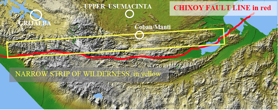
This formation is the only such geologic formation in all the Americas forming a chain of mountains, that runs from east to west, from sea to sea, that is narrow and rugged, and that could have been a viable defensive line that captain Moroni could have used to protect the Nephites on the north from the Lamanites on the south. It is the most clearly identifiable geographical feature mentioned in the Book of Mormon.
In addition, according to John Sorenson, referring to Mesoamerica, there is not another area in all the Americas where there is evidence of the use of a written language during the Book of Mormon time period (See Images of Ancient America, John L. Sorenson, 1998, page 160).
The entire area surrounding this chain of mountains contains many pre-classic and early classic ruins (Book of Mormon time period) such as Kaminaljuyú, Copán, Izapa, El Baúl, Cancuén, Nine Hills, El Portón, Abaj Takalik, Las Tunas, Izapa, La Libertad, Chiapa de Corzo, Pijijiapan, Uaxactún, amongmany others. Many of these locations contain evidence of a written language in late pre-Classic times.
II. THE LANDING PLACE OF LEHI
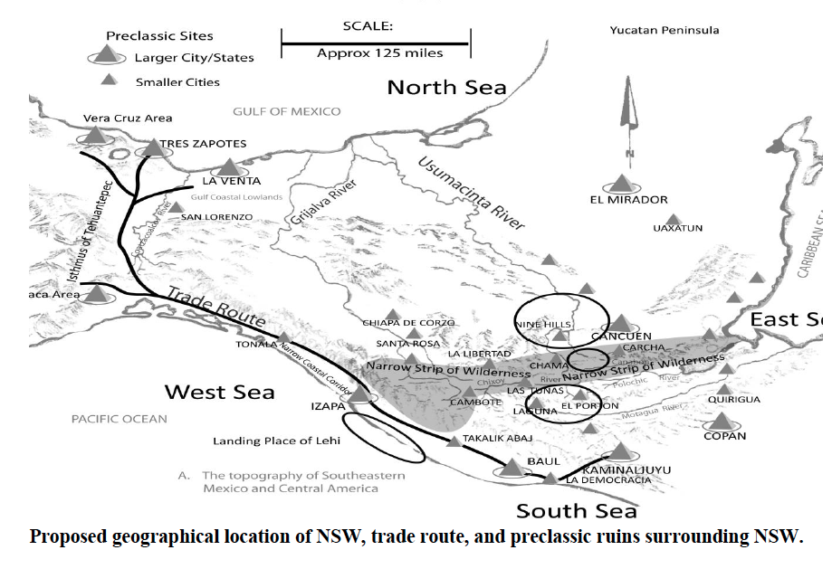
The foregoing map shows some pre-Classic and early Classic sites surrounding the NSW. It shows the respective locations of the seas north, south, east, and west relative to the NSW. It shows the general area westerly of the NSW where Lehi landed. It shows the probable location of the Pacific coast trade route from Kaminaljuyú, Guatemala, to Veracruz and Oaxaca, Mexico. It also shows where archaeologist Dr. Richard Hauck considers the area just north of the NSW near Nine Hills to be the
lesser land Zarahemla and the area just south of the NSW near El Portón and Laguna to be the lesser land of Nephi, both areas are located near the center between the east and west seas.
Helaman 6:10 states that the Lord “...did bring Mulek into the land north, and Lehi into the land
south.” A careful reading of this chapter clearly shows that the terms "land north" and "land south” had reference to the NSW and should not be confused with the Jaredite land northward. Omni 1:13 states: the Mulekites “...were brought by the hand of the Lord across the great waters, into the land where Mosiah discovered them [Zarahemla]; and they had dwelt there from that time forth.” The lands of Zarahemla and Lehi were both in the greater land southward, and therefore, Lehi was brought by the Lord to their final landing, or place of settling, southerly of the NSW, and Mulek was brought by the lord to north of the NSW.
Mormon clarifies the location of the landing place of Lehi as it relates to the NSW in Alma 22:28 stating:
“...Lamanites ...were spread through the wilderness on the west, in the land of Nephi: yea, and
also on the west of the land of Zarahemla, in the borders by the seashore, and on the west in the
land of Nephi in the place of their [Lamanites’] fathers’ first inheritance, and thus bordering
along by the seashore.”
Undeniably this describes Lehi's landing place. It was south of the NSW and west of the land of Nephi. The wilderness where the Lamanites were "spread" was in the western part of the NSW. Because it was narrow and because they landed westerly of this wilderness then the landing place of Lehi could not have been south of the city or lesser land of Nephi.
It is now without controversy that at the time that Lehi landed on the west coast of Mesoamerica there existed extensive civilizations in Mesoamerica and that there was extensive trading among the many Mayan city/states and between the Maya and the Olmec cultures.
When the Nephites landed about 588 BC somewhere near Izapa, Mexico, as will be shown hereafter, there were hundreds of thousands of people living all over Mesoamerica. There was also an ancient Pacific Coast trade route that went from present day Guatemala city, Guatemala, (Kaminaljuyú) to present day Veracruz and Oaxaca, Mexico, areas (Hauck, page 12). That route could have gone approximately as follows (see map above):
From Kaminaljuyú area, with its population of over 30,000 people;
Down to the Pacific west coast to La Democracia, with its population of several thousand;
Northward inland but following the coast to El Baúl, with its several thousand;
To Abaj Takalik with its many thousands;
To Izapa city/state with its many thousands (Lehi landed near this area);
Then to other cities along the Pacific coast to the Isthmus of Tehuantepec, and then to the many
large city/states in the area including Oaxaca, La Venta, Tres Zapotes, and San Lorenzo among
many others with their many thousands.
What a problem this must have created for Nephi with his small group of eight or nine men, eight or nine women, and 20 to 40 children under the age of 11. Not only did he have problems with the rebellious Laman and Lemuel but he had to keep his followers from losing their Jewish and Christian beliefs and succumbing to the influences of the surrounding native populations. It seems likely that Laman and Lemuel quickly mixed with the local natives and soon became a very real threat to the existence of the Nephites. Nephi had to take his people to an area where he could protect them; and to an area that was isolated from so many cultural and religious distractions so that he would have time to multiply, prosper, and expand his colony. I do not believe he would have gone to Kaminaljuyu (a city/state of about 30,000 inhabitants) as they would have either killed the Nephites or made them assimilate. He certainly did not become king of Kaminaljuyu and build a Jewish temple there as described in the Book of Mormon. I believe he went inland to a beautiful, isolated, and defensible valley snuggled just south of the center of the NSW: the Salamá Valley. Dr. Hauck has convincingly shown at least 30 criteria why the Salamá area should be Nephi (BMAF.org presentation Oct.2009).
There can be no doubt that when the Nephites left their landing place (about two or three years after arriving) and moved inland to the city of Nephi, that the land of their fathers‟ first inheritance then belonged to the Lamanites. This landing place of the “Lamanites‟ fathers‟ first inheritance” was west of the land of Nephi, not south. The landing place of Lehi could not have been south of the lesser land or city of Nephi but could only have been west and, of course, along the west seashore.
Therefore, the landing place of Lehi cannot be 150 miles south and east of the city of Nephi as stated by John Sorenson on page 37 of his book, An Ancient American Setting for the Book of Mormon. It cannot be at Usulután, El Salvador, as per Norman's 2005, map located at Mesoamerica and Book of Mormon Lands, because Usulután is south and east of his proposed location of Nephi at Kaminaljuyú . The probable location of the landing place of Lehi, therefore, must have been west of the land of Nephi and westerly and southerly of the NSW in the area near the pre-Classic site of Izapa, Mexico, as shown by both Allen in Exploring the Lands of the Book of Mormon (Allen 1989, page 268) and Hauck in Deciphering the Geography of the Book of Mormon (Hauck 1988, page 8).
III. The EAST, WEST, SOUTH, and NORTH SEAS
The east sea cannot be the Gulf of Mexico
I believe it necessary to discuss the way the Book of Mormon uses the term “sea” because some say that it can be any large body of water. While it is true some lakes are called seas, eg., Salton Sea, Sea of Galilee, Dead Sea, the Book of Mormon always uses the term in reference to an ocean or “the great waters,” Omni 16, or the “great deep” Ether 7:27. Other examples include:
I Nephi 18:7 “...put forth into the sea...and...driven...towards the promised land.”
I Nephi 17:5-6 “...we beheld the sea, which we called Irreantum, which, being interpreted, is
many waters. 6....we did pitch our tents by the seashore...”
Ether 6:4-6 “...set forth into the sea...they were tossed upon the waves of the
sea...buried in the depths of the sea.”
Ether 2:13 “...even to that great sea that divideth the land...and they dwelt in tents upon the
seashore...”
Therefore, when the Book of Mormon speaks about “...on the west...in the place of their fathers' first inheritance, and thus bordering along by the seashore (Alma 22:28)” or, “And also many Lamanites on the east by the seashore, whither the Nephites had driven them... (Alma 22:29),” it is talking about the seashore of an ocean, and not a lake or river.
Clearly the east sea (sea or gulf connected to an ocean) was east of Manti and east and maybe
slightly south of Zarahemla. As stated above it was also east of Nephi. Both the greater land of
Zarahemla and the greater land of Nephi paralleled the NSW from the east sea to the west sea (Alma
22:27; 50:1). Therefore, the east sea cannot be north of Zarahemla; it cannot be north of the NSW; and
it cannot be north of Nephi.
There is a reference to a north sea being north of Zarahemla. Helaman, living and writing from Zarahemla in the year 46 BC, states in Helaman 3:8, that the Nephites “... did go forth from the land southward to the land northward, and did spread insomuch that they began to cover the face of the whole earth, from the sea south to the sea north, from the sea west to the sea east.”
I cannot imagine Helaman stating that there was a sea north and there not be one. I cannot believe that Helaman meant that the sea north would be the same as the sea east. Therefore, from Zarahemla and the NSW the sea east would be eastward to the Gulf of Honduras. The sea north would be the Gulf of Mexico. The sea west would be the Pacific Ocean near to Izapa, Mexico. The sea south would be the Pacific Ocean south of Zarahemla near the area of Puerto Quetzal, Guatemala.
There are only three Book of Mormon references that can be cited that could remotely be construed as placing the sea east at the same location as the sea north.
1. Alma 22:32 states “...it was only the distance of a day and a half's journey for a Nephite [20 to 30 miles], on the line Bountiful and the land Desolation, from the east to the west sea....” It does not say “east sea,” though some authors believe that “east” here implies an east sea. They also believe that because it must be an isthmus and because the only isthmus in the area is Tehuantepec, that therefore, the east sea must also be the north sea or the Gulf of Mexico. However, the Book of
Mormon clearly states that the defensive line ran in an east to west direction and ended at the west sea. The defensive line did not run north to south (as does the Isthmus of Tehuantepec a distance of 125 miles) Therefore, it cannot be inferred that east meant the sea that was north unless one unjustifiably concludes that the authors of Book of Mormon did not know which way was east.
2. In Alma 22:33, Mormon was writing and informs us that the greater land of Zarahemla, about 80 BC, was inhabited sufficiently “... from the east [sea ] (Alma 22:29) unto the west sea...and thus...the Nephites had hemmed in the Lamanites on the south….” (South of the NSW). This is clearly a different line than the line between Bountiful and Desolation. Verse 34 states, “...therefore the Lamanites could have no more possessions only in the land of Nephi and wilderness round about….” At this time period, about 83 BC, the land of Nephi included everything south, and perhaps round about on the western end, of the NSW. The “east” in verse 33 probably does imply the east sea (Alma 22:29) and it would be same east sea where the NSW ends east of Manti. Certainly it does not refer to the north. If one were to infer that this east sea was the same as the north sea (north of Isthmus of Tehuantepec) then the isthmus, being the dividing line between the land of Zarahemla and the Land of Nephi would mean that everything east of the isthmus would be the land of Nephi, and Zarahemla would be everything west. This is an impossibility because the Lamanites had to have been located south of the NSW and the Nephites had to have been located to the north of the NSW.
3. Helaman 4:5-7 is the only other reference where there is a remote implication of an east sea being north of Zarahemla:
5. ...In the fifty and seventh year of the reign of the judges they [Lamanites] succeeded in obtaining possession of the land of Zarahemla; yea, and also all the lands, even unto the land which was near the land Bountiful [near the west sea].
6. And the Nephites and the armies of Moronihah were driven even into the land of Bountiful [near the west sea];
7. And there they did fortify against the Lamanites, from the west sea even unto the east; it being a day's journey for a Nephite, on the line which they had fortified and stationed their armies to defend their north country. [North here probably meant north from thedefensive line]. (emphasis and notations added)
Again, it does not say “east sea,” but it does say that the line of Moronihah's defense went in an east direction from the west sea, the distance of one day for a Nephite. Not a night. Not 24 hours. It was a reasonable distance that could be fortified with armies to defend the “north country.” It is submitted that this line of defense could not have been over 20 miles or so, and, therefore, could not have been the Isthmus of Tehuantepec, which is over 125 miles across. Clearly Moronihah stationed his armies on the entire line of defense perhaps as far as 20 miles. Also the line had to go from west to the east and not north to south as does the Isthmus of Tehuantepec. It is also submitted that the direction "north‟ in verse 7 was probably determined, not from Zarahemla, but from the location on the line which the Nephites had fortified. This “north country” would undoubtedly have included where the hill Cumorah/Ramah was located, including the entire Isthmus of Tehuantepec.
Therefore, “east” in this scripture cannot be read to be the sea north of Tehuantepec. In fact “east” should not reasonably imply a sea of any kind, but must be something else that helped Moronihah to be able to stretch his armies from the west sea to the east 20-plus miles to what? Maybe it was a large mountain. Certainly that would be much more probable than the “north sea” becoming the east sea 125 miles away. Mormon, a prophet, knew his cardinal directions and would not have said north if he meant east. I do not believe that Moronihah placed soldiers all along the 125 mile Tehuantepec Isthmus.
Therefore, it must be concluded that the east sea cannot be the “north sea,” and the east sea cannot be the Gulf of Mexico as stated by Garth Norman and John L. Sorenson.
IV. ZARAHEMLA COULD NOT HAVE BEEN 200 MILES FROM MANTI
Having established the NSW as the area of the Sierra Cuchumatanes in Guatemala, (and I believe there is no other realistic possibility) the general location of the city of Zarahemla relative to the NSW might be ascertained, not its exact geographical location but a probable distance from the NSW either on the Grijalva or the Usumacinta river systems (including major tributaries). Both of these rivers begin in the highlands of Guatemala near Huehuetenango and eventually both ran northerly toward the Gulf of Mexico. Large tributaries to the Usumacinta begin near Coban, Guatemala. While the exact location of Zarahemla cannot be determined yet, what can be determined is where Zarahemla could not have been located.
Zarahemla was the political, economic and religious center of the Nephite sphere of influence at least from the first year of the reign of the judges for about 120 years to the time of Christ's crucifixion. Zarahemla was located in “the center of our land” (Helaman 1:24, 27) and was in “the heart of our country” (Alma 60:19). It was the “capital city” and near the “capital parts of the land” (Helaman 1:27). Why would one look to Palenque, Mexico, located over 200 miles from the NSW as the location for Zarahemla? To do so would certainly not locate it in the center or heart or capital part of the Nephite empire, which was located “by” (near) the NSW.
Alma 22:27, referring to the NSW, states, “...and the borders of the wilderness which was on the north by the [lesser] land of Zarahemla....” It is unreasonable, and against the clear intent of this scripture to suggest that Zarahemla was some 200 miles north of the NSW.
Beginning the 9th year of the reign of the judges, Alma gave up the governance and judgeship of the Nephites to Nephihah, and the military command to Zoram. Alma then began a series of missionary journeys to the cities surrounding Zarahemla. After he returned from Sidom (25 to 40 miles northerly of Zarahemla) at the end of the 10th year, Alma and Amulek continued their ministry in other cities “round about , among all...the Nephites” (Alma 16:15). This implies that these cities “round about” were also located not a great distance from Zarahemla. This included the city of Manti.
In the beginning of 77 BC, as Alma was continuing his ministry from Gideon southwesterly to Manti, he met the sons of Mosiah. They had left the 10,000+ Ammonites in the NSW near Manti to await the decision of the people of Zarahemla as to their relocation (Alma 17:1; 27:14). Clearly Gideon was near Manti. Gideon was only a half nights march (5 miles) from Minon, and Minon (being located up from Zarahemla in the foothills of the NSW) was close to Manti and on the path from Zarahemla to Nephi. Both Gideon and Minon could not have been over 20 miles from Zarahemla (See Article I of Footprint of Zarahemla). It is unreasonable to believe that Gideon was 150 miles north of Manti, or that Zarahemla was 200 miles north of Manti, as shown in Norman's Map. Such distances are not consistent with the intent and descriptions contained in the Book of Mormon.
It is also unreasonable to believe that the Lamanites, so frequently coming down into the land of Zarahemla to battle, would have come down from the NSW, and then have traveled 150 miles farther northward (along the Usumacinta passing all those Mayan city/states), to have a battle at Zarahemla near Palenque. Clearly if one places Zarahemla 200 miles north of Manti, then Zarahemla would not have been in the “center” or “heart” of the Nephite population between the east and west seas.
Therefore, the placement of Zarahemla at or near Palenque in the Gulf coast region is in error. If Zarahemla were at or near Palenque, then there could be no other lands or cities north or northward because that would place them in the Grijalva-Usumacinta delta. All the cities and lands northward would have to have been directly east (or perhaps west), and thus be inconsistent with the Book of Mormon. If Zarahemla were near Palenque, then of necessity Ammonihah would have to have been 30 to 60 miles north to northwest and that would place Ammonihah right near the Gulf coast.
The obvious conclusion to me is that Zarahemla must have been located near the NSW, somewhere near the middle between the east and west seas. It would have been easterly from the landing place of Lehi and westerly from the cities of Moroni and Lehi, both of which were just north of the eastern end of the NSW (Alma 50:10-15).
This means that Zarahemla would have been located just northerly of the NSW, down in the Grijalva basin or northerly down in the Usumacinta basin. In either case, Zarahemla would not have been farther than 50 to 60 miles from the NSW, and not over 40 to 50 miles from Manti.
Since the Usumacinta basin near Nine Hills is a better agricultural area and had better prospects of sustaining larger populations; and since it is more in the center of the land between the east and west seas; and since there is a major salt source close by (Hauck, page140-153), it seems more likely that Zarahemla would have been located somewhere along the upper Usumacinta or one if its major tributaries.
The Grijalva basin is not near the center of the land and not near the center of the NSW where Manti had to have been located. In the area near the center of the NSW is a location of strategic military and commercial importance. There is a pass through the NSW where ancient trails connected Kaminaljuyú, a major city/state that thrived about 100 BC, with the city states along the Usumacinta and in the Yucatán. This pass is near Cobán, Guatemala, and even today the Coban area is a major crossroads and commercial area in the center of the country. Archaeologist Richard Hauck is confident this was Manti and he has discovered many Pre-classic defensive trenches and defensive locations that assure him that the Cobán area was where Manti was located (Deciphering the Geography of the Book of Mormon, Salt Lake City, Deseret Book Company, 1988).
Garth Norman also agrees that Cobán must have been Manti (See his map, 2005). If Cobán was Manti then Zarahemla must have been located not more than 60 miles or so northerly there from and, therefore, Zarahemla could not have been located at or near Palenque, Mexico.
Topic/Type: