


FOOTPRINT OF ZARAHEMLA Article One
FOOTPRINT of ZARAHEMLA
by Joe V. Andersen
January 10, 2008
Misinformation about Book of Mormon Geography
Materials, concepts, maps or conclusions presented at our forums or appearing on this website or
emailed to BMAF members and guests is the sole responsibility of the contribiuting author(s) and does
not necessarily imply that members of the Board of Directors or members of BMAF agree with all or
any part of the subject matter and is not sponsored in any way by the Church of Jesus Christ of Latter-day Saints
At the BMAF Book of Mormon Seminar in October of 2006, in Salt Lake City, Archaeologist Garth Norman presented an interesting paper, and issued a challenge for anyone to dispute any of his proposed locations of Book of Mormon city/lands as he has described in his map of the Geography of the Book of Mormon published in 2005.
At the moment of his issuing the challenge, I was staring in disbelief at the placement on his map of Ammonihah at or near Tikal, Guatemala, which is over 150 miles east of his placement of Zarahemla at or near Palenque, Mexico. This is impossible because the Book of Mormon definitely places Ammonihah west and north of Zarahemla, not east, and certainly not 150 miles (Alma 8:3-6). His placement of Zarahemla at or near Palenque, Mexico, is also impossible because that would put Ammonihah near or in the Gulf of Mexico. The Book of Mormon clearly puts Ammonihah 3 days north of Melek which was just west of Zarahemla and the river Sidon (Alma 8:3, 6).
While researching a response to his challenge, I discovered that there are many books and maps written on the geography and proposed locations of the cities/lands of the Book of Mormon, and most seem to be at odds with each other. Students and readers of these books and maps must be confused, and wonder which author is consistent with the text, wording, descriptions, directions, and intent as stated in the Book of Mormon. I hope to resolve this question at least to some degree.
It soon became clear that there is an objective standard or model within the Book of Mormon to determine the correctness and consistency of the placement of at least the principal cities/lands immediately surrounding and relative to Zarahemla, regardless of where one places Zarahemla on a geographical map. The objective of this article is to describe this objective standard with reference only to the Book of Mormon and its internal geography so that anyone can compare any proposed placements of these principal city/lands of the Book of Mormon. The objective of the second article is to show all the parameters stated in the Book of Mormon about the narrow strip of wilderness, hereinafter NSW, and then to document why many authors and scholars believe it to be the Cuchumatanes and Sierra de la Minas mountains in Guatemala, and why this is the only viable location for the NSW.
A thorough reading of Alma chapters 2 through 15, relating to the Amlicite-Nephite war and the ministry of Alma the younger, gives a consistent, clear and relatively precise footprint of the geographic relationship between the City of Zarahemla and the cities/lands of Gideon, Minon, Crossing of Sidon, Melek, Ammonihah, Sidom, Noah, Hermounts, and Manti. Of course the paths or roads leading to these locations were not straight, are not precisely measurable, and are not yet specifically identifiable, nonetheless, give or take a few miles and/or a few degrees one way or another, any placement of these cities/lands relative to Zarahemla and to each other outside the parameters stated in this Footprint (or model) will produce erroneous results and violate the express wording, descriptions, and intent of the Book of Mormon.
I call this standard the Footprint of Zarahemla, hereinafter referred to as Footprint. In the diagram of the Footprint, shown below, the distances stated are approximately to scale; however, the narrow strip of wilderness (NSW), the west wilderness, and the east and west seas are not.
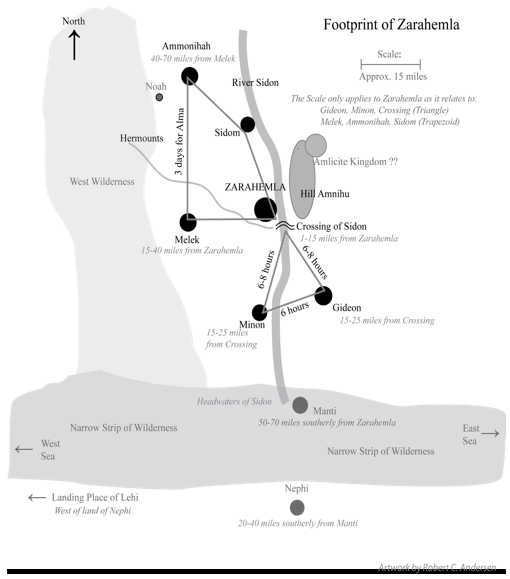
The first chapter of the Footprint shows the relationship between Zarahemla and the Crossing of the river Sidon, Gideon, and Minon, which relationships form almost an equilateral triangle. It also shows the relationship of Zarahemla to Hermounts and Manti. It shows why Gideon and Minon cannot be more than 35 miles from Zarahemla and why Manti cannot be more than 70 miles from Zarahemla.
The second chapter of the Footprint describes the relationship of Zarahemla to Melek, Ammonihah, Noah, and Sidom, which relationship forms another triangle, or perhaps a trapezoid, and it shows why Ammonihah cannot be more than 60 to 90 miles from Zarahemla and why Ammonihah cannot be east of Zarahemla. It also shows where several authors have not followed the wording, descriptions, directions, and intent of the Book of Mormon as to the locations of these city/lands relative to where each author proposes Zarahemla to be located.
The second article of the Footprint shows how the Book of Mormon describes the NSW as mountainous and where it is located in Guatemala. It also shows why it is the only possible geographical area in the western hemisphere that fits all the parameters stated in the Book of Mormon.
It is not intended by these articles to demean or denigrate the good work that authors of Book of Mormon geography have performed. It is intended to create a tool or template based only upon the wording, descriptions, directions, and intent given in the Book of Mormon that can be used to help locate these various named cities and lands and not get caught up in the excitement of guessing and speculating which great ancient ruin might be a specific city or land of the Book of Mormon.
It is my sincere desire to follow the descriptions and intent stated in the Book of Mormon. I have no axe to grind, position to defend, or books to sell. I have never written or published anything before. I do not excuse what I have written but sincerely desire it to be correct, and will respect and request anyone to add to or explain where I have not followed the Book of Mormon. If these articles stimulate honest inquiry and discussions about the geography of the Book of Mormon I will feel rewarded.
I wish to emphasize that no one's testimony of the Book of Mormon should be based upon the geography or physical evidences of it but only upon a spiritual confirmation of the truthfulness of the Book of Mormon, which mine is. However, the study of the geography of the Book of Mormon is fascinating. Even the Prophet Joseph Smith was caught up in it as will be discussed.
The first two chapters will deal in the abstract without reference to any geographical location. The term “lesser land of” will be used to denote populated areas surrounding a city. The term “greater land of” will be used to describe the larger lands from the east sea to the west sea (Richard Hauck, Deciphering the Geography of the Book of Mormon, 1987, page 27). Highlights and additions to quotes are mine.
A summary as to what the Book of Mormon says about Zarahemla will help understand its relationship with the city/lands of Gideon, Minon, the Crossing of Sidon, Melek, Ammonihah, Sidom, Noah, Hermounts, and Manti at the time of the Amlicite insurrection (ca. 87 BC) and shortly thereafter.
1. Zarahemla was in “the heart of our country” (Alma 60:19) and was the “center of our land” (Helaman 1:24, 27). Zarahemla was the “capital city” and near the “capital parts of the land” (Helaman 1:27).
2. Zarahemla was located north of and “by” the Narrow Strip of Wilderness (hereafter NSW) (Alma 22:27).
3. Zarahemla was located in the lowlands, being lower in elevation and to the north of Minon. Minon was lower, to the north of, and near the center of the NSW where the city of Manti and the headwaters of Sidon were located. Manti was located southerly from Zarahemla on the pathway to the city of Nephi (Alma 2:24, Alma 22:27, Alma 17:1).
4. Zarahemla was located on the west side of the river Sidon (Alma 2:15). The river Sidon flowed from its headwaters near Manti in a northerly direction past Zarahemla (Alma 22:27).
5. Zarahemla was where Alma the younger lived in ca. 83 BC (also 10th year of the reign of the judges). It was from here that he started and concluded his ministry among the Nephites and where he lived when his recorded time on earth ended at the beginning of the 19th year of the reign of the judges, indicating that his writings and directions were probably from Zarahemla.
6. Zarahemla was the geopolitical, religious, and military center of the Nephite sphere of influence from at least ca.130 BC to at least ca. AD 200 (Alma 60:19 and Hel.1:27).
7. Manti was located on the path to Zarahemla from Nephi and was located approximately midway between the east sea and the west sea in the NSW. Therefore, Manti was located in a southerly direction from Zarahemla (Alma 22:27).
8. Between Zarahemla and the east sea were located the cities of Aaron, Nephihah, Antionum, Jershon, and Moroni (Alma 50:11-14; 31:3).
9. Between Zarahemla and the west sea were located the cities of Melek, Cumeni, Antiparah, and the unnamed city near the west sea (Alma 8:3; 56:14; 52:11-13).
10. Zarahemla was where the Mulekites were directed by the Lord to settle after first landing on coast of the north sea. They then traveled up the river Sidon (southerly) to their “second landing” at Zarahemla (ca. 580 BC) where they remained thereafter (Omni 12:16; Alma 22:30).
The Lord led King Mosiah and the faithful Nephites to Zarahemla about 180 BC to 200 BC, and the Mulekites and Nephites merged. Notwithstanding the Mulekites were much more numerous than the Nephites, Mosiah was accepted as the King of both groups. Apparently there were many Mulekites that were not happy with this Nephite “invasion” because, about 90 years later in the year 87 BC, there was a major revolution in Zarahemla. The Amlicites (rebellious Nephites/Mulekites) desired to have their own king and apparently entered into an alliance with the Lamanites, as will be shown.
A careful reading of the battle between the 20,000+ dissident Amlicites against the 30,000+ Nephites in the fifth year of the reign of the judges (ca. 87 BC) will help understand the geographical relationships of the Crossing of Sidon, Gideon, Minon, and Hermounts relative to Zarahemla (Alma 2:15-37):
15. And it came to pass that the Amlicites came upon the hill Amnihu, which was east of the river Sidon, which ran by the land of Zarahemla, and there they began to make war with the Nephites. (Note, the war was not with the Nephite army yet, apparently the Amlicites desired to get the Nephite army out of Zarahemla.)
16. Now Alma, being the chief judge and the governor of the people of Nephi, therefore he went up with his people. Yea, with his captains and chief captains, yea, at the head of his armies, against the Amlicites to battle.
17. And they began to slay the Amlicites upon the hill east of Sidon. And the Amlicites did contend with the Nephites with great strength, insomuch that many of the Nephites did fall before the Amlicites.
18. Nevertheless the Lord did strengthen the hand of the Nephites, that they slew the Amlicites with great slaughter, that they began to flee before them.
19. ...The Nephites did pursue the Amlicites all that day and did slay them with much slaughter, insomuch that there were slain of the Amlicites twelve thousand five hundred thirty and two souls; and there were slain of the Nephites six thousand five hundred sixty and two souls.
20. And... When Alma could pursue the Amlicites no longer he caused that his people should pitch their tents in the Valley of Gideon...for the night.
21. And Alma sent spies to follow the remnant of the Amlicites....
22.
23. And... on the morrow they returned into the camp of the Nephites being greatly astonished and struck with much fear, saying:
24. Behold, we followed the camp of the Amlicites, and to our great astonishment, in the land of Minon, above the land of Zarahemla, in the course of the land of Nephi, we saw a numerous host of the Lamanites; and behold, the Amlicites have joined them;
25. And they are upon our brethren in that land; and they are fleeing before them with their flocks, and their wives, and their children, towards our city; and except we make haste they obtain possession of our city, and our fathers, and our wives, and our children be slain.
26. ... and the people of Nephi took their tents and departed out of the valley of Gideon towards their city, which was the city of Zarahemla.
27. And behold, as they were crossing the river Sidon, the Lamanites and the Amlicites, being as numerous almost, as it were, as the sands of the sea, came upon them to destroy them.
28. And...Alma fought with Amlici....
29.
30.
31. …and slew Amlici with the sword.
32.
33. But Alma with his guards contended with the guards of the King of the Lamanites until he slew and drove them back
34. And thus he cleared...the bank, which was on the west of the river Sidon, throwing the bodies of the Lamanites who had been slain into the waters of Sidon, that thereby his people might have room to cross and contend with the Lamanites and the Amlicites on the west side of the river Sidon.
35. And...when they had all crossed the river Sidon that the Lamanites and the Amlicites began to flee before them, notwithstanding they were so numerous they could not be numbered.
36. And they fled before the Nephites towards the wilderness which was west and north, away beyond the borders of the land, and the Nephites did pursue them with their might and did slay them.
37. Yea...until they were scattered on the west and on the north, until they reached the wilderness, which was called Hermounts.
Alma 3:1 ...after they had finished burying their dead they all returned to their lands, and to their houses, and their wives, and their children. (Emphasis and commentary added)
It appears that because the Amlicites started the fight on the hill Amnihu against the Nephites (not the army but against the Nephites living in that area) that the Amlicites forced Alma to take his army across the river Sidon eastward to Amnihu to protect his people in that area. It seems likely that this was a decoy to get Alma out of Zarahemla so that the descending Lamanites could take Zarahemla while the Nephite army followed after the Amlicites.
Analyzing the above scriptures we can objectively locate the city/lands of Minon, Gideon, and the Crossing of Sidon relative to Zarahemla.
I. THE CROSSING OF SIDON (1 to 15 miles south of Zarahemla)
The Crossing of Sidon (hereafter Crossing) had to have been south of the city of Zarahemla between a mile or so but not over 15 miles. It was certainly not directly east of the city as will be shown.
The first day of the war between the Amlicites and the Nephites commenced at or near the Crossing and on the first evening Alma camped in the valley of Gideon which was south and east of the Crossing, as will be shown hereafter. When the Nephite spies returned early the next morning they told Alma “...except we make haste they obtain possession of our city (Zarahemla), and our fathers, and our wives, and our children be slain...” and then later it says “...after they had finished burying their dead they all returned to their lands, and to their houses, and their wives, and their children” (Alma 2:25 and Alma 3:1). Therefore, the Nephites were able to repel the Amlicite/Lamanite armies at the Crossing before they got into the city of Zarahemla.
As the huge battle progressed that afternoon at the Crossing, the Lamanite/Amlicite armies fled west and north (Alma 2:36). Had the Crossing been directly east of Zarahemla, the enemy would have been forced through the middle of the city as it fled in a westerly direction. This clearly did not happen. Because the Lamanite/Amlicite armies met the Nephite army at the Crossing, they never reached the city of Zarahemla. The Nephite lands, houses, wives, and children were still there. The people and cattle killed and the lands trampled upon could only have been those around Minon and perhaps the outer agricultural areas south of Zarahemla. Therefore the Crossing must have been south of city of Zarahemla.
We also learn from these scriptures that the Nephite army could have reached Zarahemla within one day, perhaps 20 to 35 miles from Gideon. As we will learn in the next section, we know that the Crossing was not over 25 miles from Gideon, so therefore, the Crossing could not have been over 15 miles from Zarahemla, and it was probably much closer.
II. THE CROSSING TO GIDEON (15 to 25 miles [6 to 8 hours] south and east)
The first day of the war ended when the Nephites stopped at the valley of Gideon that first night. On that same day 12,532 Amlicites were slain, either on the hill or as they were fleeing in a southeasterly direction towards the valley of Gideon. Alma lost 6,562 men, and when that evening came Alma rested and camped for the night (Alma 2:19-20). How far did Alma and his army travel that first day? It was surely not over 25 miles considering the terrain and the fighting, first on the hill Amnihu and later while following and fighting the fleeing Amlicites.
Nonetheless, the distance between the Crossing and Gideon must be the same as the distance between the Crossing and Minon, and cannot be over 25 miles (see section IV below). This is the first leg of the triangle from the Crossing to Gideon of approximately 20 miles in a southeasterly direction. It had to have been southeasterly because Minon was in a southerly direction from Zarahemla and in a westerly direction from Gideon.
III. GIDEON TO MINON (10 to 20 miles [6 hours] in a westerly direction)
While the Nephites were camping that first night, the Amlicites (without fighting) traveled until about midnight before they could rest when they joined with the Lamanite army at Minon, Their objective was to reach the city of Zarahemla ahead of Alma (Alma 2:24). How far did the tired and beaten Amlicite remnant army travel by about midnight from Gideon to Minon? A very reasonable distance would be 10 to not over 20 miles in about 6 hours, especially considering that they had fought all day and probably had to care for many wounded. We know it was about midnight because the Nephite spies had to return to the valley of Gideon by early the next morning. This is the second leg of the triangle. We can determine the direction of this second leg (westerly) after we determine the distance and direction of the third leg. This is because once we know the distance and direction of one leg of an equilateral triangle we can determine the directions and distances of the other legs.
IV. MINON TO THE CROSSING (15 to 25 miles [6 to 8 hours] in a northerly direction)
It is a safe assumption that the next morning both the Lamanite/Amlicite armies and the Nephite army traveled about the same distance, because they traveled at about the same speed, and arrived at the Crossing at about the same time. Actually the Lamanite/Amlicite armies arrived slightly ahead of the Nephites because the Nephites were pinned in the river for a while (Alma 2:27-34). A tremendous battle raged that afternoon starting at the west bank of the river Sidon. How far did these two armies travel the morning of the second day to the Crossing? A reasonable estimate would be not over 25 miles in probably about 6 to 8 hours. This is the last leg of the triangle. Because the distance between each of these locations is about the same, this relationship forms an almost equilateral triangle, each leg of which should not be over 25 miles, give or take a few miles.
Because Minon was up in elevation from Zarahemla and on the path to the city of Nephi, and because Nephi was south of the NSW and south of Zarahemla, then Minon had to have been mostly south of Zarahemla and mostly south of the Crossing. This means that Gideon must have been south and east of the Crossing, and, therefore, Minon must be mostly west of Gideon. This is also consistent with Alma 17:1 where Alma was traveling from Gideon in a southwesterly direction toward Manti, which was located in the NSW near the headwaters of the river Sidon and on the path to Nephi.
The conclusion is inescapable that the relationship between Minon, Gideon, and the Crossing forms an almost equilateral triangle with the distance between each location not over 25 miles (6 to 8 hours) as shown in the Footprint. The distance between Minon and Gideon was probably not over 15 miles because it was only a 6-hour march at night.
As that terrible battle at the Crossing of Sidon progressed, the Lamanites and remnant Amlicites fled west and then north until they left the borders of Zarahemla into the wilderness of Hermounts with the Nephite army pursuing them all the way. “...they [Lamanites and Amlicites] fled before the Nephites towards the wilderness which was west and north, away beyond the borders of the land...yea they were...slain and driven, until they were scattered on the west, and on the north, until they reached the wilderness, which was called Hermounts....” (Alma 2:35-38). Therefore, Hermounts must be west and north from the Crossing and somewhere between Melek and Ammonihah and probably west thereof because they fled “away beyond the borders of the land....” Melek and Ammonihah were in the borders of the land of Zarahemla (Alma 25:2).
VI. MANTI to ZARAHEMLA (50 to 70 miles in a southerly direction from Zarahemla)
Although there is no specific reference to the distance between Zarahemla and Manti, the following corroborate that Manti was not over 50 to 70 miles in a southerly direction from Zarahemla:
1. Manti was part of the defensive line within the NSW that separated Zarahemla from Nephi (Alma 22:27).
2. Manti was south and west of Gideon, and therefore, in a southerly direction from Minon. Minon was 15 to 35 miles in a southerly direction from Zarahemla in the foothills of the NSW (Alma 2:24). The NSW was narrow and Manti was in the northern edge thereof. Therefore, Manti should not have been more than 15 to 30 miles in a southerly direction from Minon. This seems consistent with Alma 17:1 where Alma was going to Manti on his ministry from Gideon when he met the sons of Mosiah who had just left the Ammonites near Manti to await the decision of the Nephites as to their locating in the land of Jershon, which was located easterly from both Manti and Zarahemla (Alma 27:14-16; 27:22; 31:3).
3. Manti was west of the east end of the NSW where the cities of Moroni, Jershon, and Antionum were located (Alma 50:13; 27:22-23). Zarahemla was west of the east sea where Antionum was located (Alma 31:3). Antionum was adjacent to and just south of Jershon (Alma 31:3). Therefore, because Antionum and Jershon and Moroni were close to each other, and Antionum was east of Zarahemla and Moroni was east of Manti, then Manti and Zarahemla likewise were not far apart. Remember both the lands of Nephi and Zarahemla were parallel and adjacent to the narrow strip of mountainous wilderness which ran in a straight course. .
4. Manti was on the northern edge of the NSW and Zarahemla was “by” the NSW (Alma 22; 27).
5. Manti was not near either the east or west sea and Zarahemla was also not near either sea (Alma 22:27).
6. The headwaters of the river Sidon were high up in elevation near the land of Manti and the Sidon flowed in a northerly direction to the north sea, past Zarahemla on the east side thereof (Alma 22:27, and Alma 2:15).
7. Zarahemla was located close by the northern edge of the NSW: “...the borders of the [narrow strip of] wilderness which was on the north by the land of Zarahemla, through the borders of Manti, by the head of the river Sidon....” (Alma 22:27).
8. Zarahemla was immediately down from Manti and other cities nearby. In 66 BC, the Lamanites had captured several cities in the NSW, including Manti, and their capacity to defend these cities was limited. In Alma 56:25 it says, referencing the Lamanite army at Manti: “Neither durst they march down against the city of Zarahemla; neither durst they cross the head of Sidon, over to the city of Nephihah.” This indicates that both Zarahemla and Nephihah were in close proximity to Manti and were considered and dismissed as targets of attacks. The word “over” here seems to indicate that it is used mostly when referencing a crossing. Richard Hauck suggests that this is the most common usage of the term “over” and probably means crossing over water.
9. Manti could not have been more than a two-day march (40 to 70 miles) from Zarahemla, because in one day, during the battle for Manti in ca. 63 BC, Helaman and his 2000 stripling warriors decoyed the Lamanite army stationed in Manti. In Alma 58:23-25 it states:
23. And...We took our course, after having traveled much in the [narrow strip of] wilderness towards the land of Zarahemla.
24. And when the Lamanites saw that they were marching towards the land of Zarahemla, they were exceedingly afraid...therefore they began to retreat into the wilderness again (apparently they had left the NSW and then recognized they were headed toward Zarahemla).
25. And...it was night and they did pitch their tents....”(Alma 58:23-25).
This happened in one day. It seems likely that the reference to the “land of” refers to the lesser land of or city of Zarahemla because that is where the strength of the Nephites was located.
It seems clear from the above references that Zarahemla was within about two days striking distance north from Manti and, therefore, the distance between these two cities could not have been over 50 to 70 miles. In Alma 22:27 where it says the land of Zarahemla was by the borders of the NSW it certainly means that the land of Zarahemla in ca. 91 BC was not the greater land of Zarahemla because the Nephites had not yet expanded their borders to the east sea. This expansion did not occur until Moroni chased the Lamanites out of the east sea area and established the cities of Moroni, Lehi, etc., commencing about the year 76 BC (Alma 28:1) to about 72 BC (Alma 50:7-10). This reference in Alma 22:27, ca .91 BC, surely describes the lesser land of Zarahemla including the city and lands immediately surrounding the city of Zarahemla
CHAPTER TWO
Location of the cities of Melek, Ammonihah, Sidom and Noah with reference to ZARAHEMLA.
This is accomplished by following the first missionary journey of Alma after he left the judgeship and governance of the Nephites to Nephihah, and the control of the military to Zoram in the beginning of the 9th year of the reign of the judges (ca. 83 BC). Three years had passed since the battles between the dissident Amlicites and the Nephites in which Alma was injured, apparently seriously (Alma 3:22).
Alma began a two year missionary journey at the beginning of the 9th year of the judges. Alma 5:1 states: “...Alma began to deliver the word of God unto the people, first in the land of Zarahemla, and from thence throughout all the land.” Note that the “land of Zarahemla” here refers to the city of Zarahemla and local adjacent areas and not the greater land of Zarahemla. Frequently the Book of Mormon states “land or city of” (Alma 56:14). In Alma 25:2 it appears that the “borders of the land of Zarahemla” included Ammonihah and Melek.
Towards the end of that year (four years after the Amlicite battle) Alma went to the land of Gideon (which was then a city about 20 to 35 miles south and east from Zarahemla) and established the church there. And then “...yea, he returned to his own house at Zarahemla to rest himself from the labors which he had performed” (Alma 8:1).
I. ZARAHEMLA TO MELEK (15 to 40 miles west)
At the beginning of the 10th year of the judges Alma departed Zarahemla and “...took his journey over into the land of Melek on the west of the river Sidon, on the west by the borders of the wilderness” (emphasis added) (Alma 8:3-5). He went towards the west from Sidon (at least from some point near Zarahemla) until he came to the borders of a wilderness (perhaps mountainous) area. Note he did not go into the wilderness nor did he cross the wilderness. He clearly stayed within the borders of the land of Zarahemla.
This wilderness area could have been part of the Narrow Strip of Wilderness (hereafter NSW ) that was just to the south of Zarahemla and above Minon, or it could also include another wilderness area on the west side of Melek. It is more reasonable and logical that this was a west wilderness that went from the NSW northerly, including Hermounts, and past Ammonihah. Ammonihah was located mostly north of Melek and was also in the borders of, but not in the western wilderness (Alma 16:2 and Alma 8:6).
Clearly Alma began his missionary journey from Zarahemla. Alma 8:3 states “...Alma departed from thence and took his journey over into the land of Melek, on the west of the river Sidon...” Therefore, Melek should be westerly from Zarahemla. “Thence” here clearly referred to his home at Zarahemla.
It also seems clear that Alma was trying to establish the church in all the major cities close to Zarahemla and, therefore, Melek was not a great distance from Zarahemla but something like the distance to Gideon. As Gideon was the closest major city eastward of Zarahemla, Melek was likely the closest major city westward of Zarahemla. This was 7 years before the Ammonites resettled there.
It must be recognized that Melek was never attacked and that it was perhaps the safest place for the relocation of the people of Ammon from Jershon. Once the people of Ammon were relocated there (in the 17th year of the reign of the judges) Melek became a large city (of at least 10,000 Ammonites in addition to the Nephites). Melek was a righteous city where 2,060 stripling righteous warriors were reared, and later sent to the western battlefront that extended from Manti to Cumeni to the west coast area.
The Nephites had covenanted to protect the Ammonites (Alma 27:23-24), and therefore, it is more probable that they would not have relocated them in the west or south wilderness where they would have been hard to defend, but would have relocated them in a very strategic political, religious, and militarily defensive location.
The Ammonites also pledged “...on condition that they will give us a portion of their substance to assist us that we may maintain our armies....” (Alma 27:24). Therefore, Melek must have been close enough for them to help provide for the Nephite armies with produce that could have been relatively easy to transport to Zarahemla. Author Richardson Benedict Gill agrees with studies that prove that the maximum distance foods could be reasonably transported by humans walking to a major city/state would be about 18 to 30 miles or the “radius of one day’s journey” (The Great Mayan Droughts, Gill 2000, page 77).
It is also probable that Melek was located in a large and favorable agricultural area as it had to support a population, including Ammonites, of about 15,000 to 20,000 inhabitants and supply goods for the Nephite army in Zarahemla as well. It is unlikely that this would have been in the wilderness or mountainous area, although it seems to have included at least the wilderness side. The people came to hear Alma for “...the people came to him throughout all the borders of the land which was by the wilderness side….” (Alma 8:5) (Emphasis added)
It seems reasonable and scripturally accurate that Melek was probably protected by mountains or wilderness on the south and west and by Zarahemla on the east. The Lamanite armies clearly had to travel west of Melek, in the wilderness on the west, in order to attack Ammonihah, supporting the belief that Melek was close to Zarahemla (Alma 16:2 and 25:2).
It seems likely that Melek, like Gideon, was as close as 15 miles but not over 40 miles from Zarahemla. It could only have been west of Zarahemla and perhaps slightly south but not more than 15 miles. (That is if “west of Sidon” began at the crossing of Sidon, since the Crossing could not have been over 15 miles south of Zarahemla. See chapter One)
This forms the first leg of the approximate right triangle from Zarahemla, or the crossing of Sidon, west to Melek, a distance from Zarahemla of about 25 miles.
II. MELEK TO AMMONIHAH (60 to 80 miles north)
Alma 8:6 states: “So that when he had finished his work at Melek he departed thence and traveled three days' journey on the north of the land of Melek; and he came to a city which was called Ammonihah.” (Emphasis added)
Ammonihah was three days journey for Alma “north” of Melek. Thus Ammonihah must have been about three times farther from Melek than Gideon was from Zarahemla, and yet it was considered to be in the “borders of the land of Zarahemla” (Alma 25:2). Clearly Ammonihah and Noah were far enough from Zarahemla that the Nephites did not have time to mount a defense, in the 11th year before the city was destroyed in one day by the Lamanites (Alma 16:10). It is also probable that the Lamanite army came upon the city of Ammonihah from the west wilderness as it states in Alma 16:1-3:
1. ...until the fifth day of the second month of the eleventh year, there was a cry of war heard throughout the land.
2. For behold, the armies of the Lamanites had come in upon the wilderness side, into the borders of the land, even into the city of Ammonihah...
3. ...before the Nephites could raise a sufficient army to drive them out of the land, they had destroyed the people who were in the city of Ammonihah and also some around the borders of Noah, and taken others captive into the [west] wilderness. (Emphasis added)
This wilderness seems to have been west and then south from Ammonihah and it was probably the same wilderness that was west of Melek. It was likely the same wilderness that was west and north of the Crossing near Zarahemla called Hermounts. This scripture also indicates that Noah must have been close to Ammonihah and was probably near the west wilderness and probably south of Ammonihah.
This seems apparent since the attacking Lamanites crossed the NSW passing Melek on the west because if they would have passed on the east they would have first passed near Minon and then between Melek and Zarahemla, and the Nephites would have been alerted.
Ammonihah was a city that was in the borders of Zarahemla and a city the Lord told Alma to work in. It was a major city and part of the political and military responsibility of Zarahemla (Alma 8:12). Alma could walk to Ammonihah in three days from Melek going mostly north. This places Ammonihah not more than 60 to 90 miles west and north of Zarahemla. Probably the lower miles would apply because of Alma's age, health, and that he was not in a hurry, at least initially.
This forms the second leg of the triangle/trapezoid placing Ammonihah about 60 miles north of Melek.
III. AMMONIHAH TO SIDOM (20 to 30 miles south and east)
Alma was in Melek several months and about six months in Ammonihah (Alma 14:23 and 10:6). He and Amulek suffered greatly from starvation, incarceration, ridicule, and persecution. They were also subjected to watch men, women, and children who believed them, be burned and tortured to death. Surely they would have been most anxious to return to Zarahemla and rest like Alma had done when he finished his labors in Gideon (Alma 15:18).
After the walls of the jail in Ammonihah had fallen, the Lord told Alma and Amulek to go to Sidom and there they administered to those who had believed them and fled from Ammonihah. It is unlikely that these people would have fled away from their center of protection, Zarahemla, or that Alma would have traveled farther away from his home after suffering such an ordeal as he had in Ammonihah.
Therefore, Sidom must have been located on a route toward Zarahemla and possibly near the river Sidon (see John L. Sorensen, An Ancient Setting for the Book of Mormon, 1985, page 241). Sidom was probably not near a wilderness area (Alma 15:1, 14). It must have been located a sufficient distance from Ammonihah to afford protection against the people of Ammonihah and close enough for Zarahemla to protect it. A reasonable distance should be 20 to 30 miles from Ammonihah, south and east toward Zarahemla, and, therefore, about 30 to 60 miles from Zarahemla.
IV. SIDOM TO ZARAHEMLA (30 to 60 miles south or southeasterly)
After comforting the people at Sidom for about a month, Alma and Amulek returned to Zarahemla to Alma's home, and there he administered to Amulek at the end of the 10th year of the reign of the judges (Alma 15:18-19). This completes the trapezoid coming from Ammonihah south and east toward Sidom and then southerly one to two days to Zarahemla.
This completes the objective guide to these locations and is a reliable Footprint with which to compare proposed geographical placements of the cities/lands of Gideon, Minon, Melek, Ammonihah, Sidom, Noah, Hermounts, and Manti relative to Zarahemla, no matter where one desires to place Zarahemla on a geographical map.
CONCLUSIONS AND COMPARISONS
It is this writer’s opinion that of all the writers of Book of Mormon geography, archaeologist Richard Hauck, in general, is the most consistent with directions, distances, and descriptions given in the Book of Mormon (see page 141 in his book Deciphering the Geography of the Book of Mormon,1988). However, I think that his placement of Melek west and south of Zarahemla and west of Manti (see page 66) in the NSW is in error. Melek should be westerly of Zarahemla and not of Manti as shown in the Footprint. That would place Ammonihah properly west and north of Zarahemla instead of west. Richard Hauck agrees with this conclusion (Personal communication).
Sorensen seems to be somewhat consistent in the placement of these cities/lands relative to his location for Zarahemla. However, he makes a major error when he uses a “Nephite north” (about 45 degrees west of north) instead of cardinal north. He then misplaces Melek north and west instead of west; and 75 miles from Zarahemla in the wilderness instead of within 30 miles and east of the wilderness.
Give or take a few miles and movement of directions a few degrees one way or another, any deviation from this Footprint of the spatial relationship to Zarahemla of the above named city/lands would be in error because it would violate the wording, descriptions, directions, and intent of the Book of Mormon.
Before citing a few probable errors by various authors, I wish to acknowledge the tremendous work that Garth Norman has performed over many years. At Izapa where he mapped the site and made the wonderful drawings of the Izapa stelae including the oft-mentioned Tree of Life Stone or Stela No. 5.
Also, I acknowledge the great work of other authors and archaeologists; however, I believe many have not been consistent in following the directions and intent of the Book of Mormon as to the probable locations of the herein named city/lands and their relationship to their proposed location of Zarahemla.
In comparing and contrasting this Footprint with several authors of Book of Mormon geography, it seems clear to me that they are mistaken in the following particulars:
1. Ammonihah cannot be east of Zarahemla at Tikal, Guatemala.
2. Ammonihah cannot be 150 miles from Zarahemla.
3. Ammonihah cannot be south of Zarahemla.
4. Ammonihah must be west and north of Zarahemla. Therefore, Ammonihah cannot be located at or near Tikal, Guatemala, which is located about 150 miles almost due east of his proposed Zarahemla site at or near Palenque, Mexico.
5. Melek cannot be east of Zarahemla. It must be west.
6. Melek cannot be south of Zarahemla. It must be west
7. Melek cannot be 120 miles from Zarahemla. It cannot be over 35 miles.
8. Minon (Menon) cannot be 60 plus miles from Zarahemla. It cannot be more than 35 miles (less than one day).
9. Gideon cannot be 70 plus miles from Zarahemla. It cannot be more than 35 miles (one day).
10. Minon (Menon) cannot be south and east of Zarahemla. It must be mostly south and perhaps a little west.
11. Noah cannot be east and south of Zarahemla but must be west and north.
12. Noah cannot be 150 miles from Zarahemla. It cannot be more than 90 miles.
13. Sidom cannot be south and east but must be north and maybe a little west of Zarahemla.
1. Ammonihah cannot be directly west of Zarahemla. It must be west and north and is not over 60 to 90 miles away.
2. The west wilderness cannot be east of Melek. It must be west. Melek cannot be on or near the west seacoast.
3. Ammonihah cannot be 150 miles from Zarahemla.
4. Minon cannot be north and east of Zarahemla, but must be mostly south.
5. Gideon and Minon cannot be 60 miles from Zarahemla. They cannot be over 35 miles.
6. Noah cannot be due west of Zarahemla, but must be west and north.
As to Jerry L Ainsworth (Page 132, Lives and Travels of Mormon and Moroni, 2000):
1. Melek cannot be 250 miles from Zarahemla.
2. Melek cannot be north and west of Zarahemla. It can only be west, maybe slightly south, and not over 40 miles from Zarahemla.
3. City Bountiful cannot be at Palenque because Bountiful must be on the east coast half day north from Mulek which is over 250 miles east of Palenque.
As to Robert A. Pate (Page 1, Mapping the Book of Mormon, 2002):
2. Ammonihah cannot be north and east of Zarahemla. Ammonihah must be north and west of Zarahemla.
3. Melek cannot be east of Zarahemla it must be west.
4. Zarahemla cannot be near the west or the south sea but must be inland in the middle of the country between east and the west seas.
5. Mulek cannot be near the west sea but must be near the east sea (Alma 51:26).
1. Zarahemla cannot be near the Gulf of Honduras coast as shown by Christensen and it cannot be within 20 miles thereof as that would place Ammonihah in the Gulf of Honduras.
2. Mulek cannot be west of Zarahemla it must be easterly (Alma 51:26).
3. City Bountiful cannot be west of Zarahemla it must be east.
There are many more authors and proposed maps that could be cited as not being in conformity with the intent, descriptions, and directions stated in the Book of Mormon as to these lands and cities.
One wonders how so many scholars can read the same Book of Mormon and come to so many different conclusions as to the locations of Ammonihah, Noah, Melek, Gideon, Sidom, Minon, Hermounts, Manti, and the river Sidon relative to Zarahemla.
It seems as if some Book of Mormon scholars believe that Mormon and the other Book of Mormon authors did not know cardinal directions. When the Book of Mormon authors wrote east, they meant east and not west or maybe north. Apparently some modern archeologists and scholars have found large ancient ruins that possibly date to the desired time period and just plugged in these sites as Book of Mormon cities without regard to the directions and descriptions given in the Book of Mormon.
It is inconceivable that Mormon and all the Book of Mormon authors did not know the sun rose in the east. These prophets knew the cardinal directions. Clearly Nephi knew “south-southeast” and “nearly” east when he was traveling down the Arabian Peninsula. These were clearly accurate geographical cardinal directions. He had the Liahona there and he had it in Mesoamerica. Surely the Lord and his prophets knew the cardinal directions and when they said east they meant east and not north. Authors in agreement with this proposition include Richard Hauck, Joseph Allen, and John L. Lund.
If we are ever to find the locations of any of these cities/lands of the Book of Mormon we must adhere to and be consistent with the precise wording, directions, and spatial relationships as contained in the Book of Mormon. I believe that this Footprint could serve as a study guide for helping to locate and identify some of these locations. At the least it will serve the student of the Book of Mormon so that he or she can compare anyone's proposed geographical placement of any of the above-mentioned city/lands and determine whether or not the author is consistent with the internal geography of the Book of Mormon as these cities/lands relate to Zarahemla. The next article will apply this Footprint to a specific proposed geographical location in Guatemala.