


Why city “Lib” was not located at La Venta or anywhere on the Gulf Coast of Mexico
on the Gulf Coast of Mexico
by Joe V. Andersen
November 2010
This article will show why city of “Lib” (built new by King Lib about 900 BC) could not have been located at the 1200 BC site of La Venta which was located near the Gulf Coast on an island and within a swampy delta. This article will also show why the city of “Lib,” according to the Book of Mormon, was located by the west sea, and just north of west sea land Bountiful and why it might have been located at the same place as city Desolation.
When did King Lib live according to the Book of Mormon?
The last great battle of the Jaredites took place about 250-300 BC.
Rather than rely on biblical sources to date Jaredite events, it seems much more logical, efficient and credible to rely upon the Book of Mormon and start at the end of the Jaredite war about the time when Corriantumr died in Zarahemla and trace the generations backward in time to the time of King Lib.
This date of about 250-300 BC for the last battle of the Jaredites can be derived from the Book of Mormon as follows:
The 43 scouts of Limhi discovered the remains of the Jaredites in the year 121 BC. Mosiah 8:8 states: “…having discovered a land which was covered with [dry] bones of men, and of beasts, and was also covered with ruins of buildings of every kind having discovered a land which had been peopled with a people who were as numerous as the hosts of Israel. Mosiah 8:11…they have brought swords. The hilts thereof have perished, and the blades thereof were cankered with rust;”
How long does it take for iron to rust in a tropical climate when the iron is on the surface of the ground? Remember the hilts of the swords were completely rusted out. I have seen 1/16 inch iron plate completely rusted out in Arizona over a period of 30 to 40 years when it was on the ground and also exposed to moisture. I have seen steel cankered with rust in that same time period. I have also seen graveyards of cattle bones disappear completely over that same time period whether by decay, covering up with dust and or vegetation, or carried away by animals. I personally believe that those dry bones and rusted swords that covered the ground when observed by Limhi’s scouts would not have been so visible much longer than 100 years following the last battle. Therefore, I believe that the last battle of the Jaredites occurred more likely about 225 BC (121 plus about 104). Some scholars place the battle at around 350 BC. The Allens place the date at 250 BC (See Allens’ book Exploring the Lands of the Book of Mormon, 2010 2nd edition, page 119). Therefore, an average date of 250-300 BC seems to be a reasonable estimate, give or take 50 years or so
It also appears that this is confirmed by the fact that King Mosiah 1 migrated to Zarahemla from Nephi about the year 200 BC and Coriantumr had already lived eight moons and died at Zarahemla some years prior to Mosiah’s arrival, corroborating that the last battle of the Jaredites probably occurred not sooner than about 25 years or so before Mosiah’s arrival at Zarahemla. (Coriantumr had to have lived at Zarahemla because the Lord brought Mulek (about 550 or so BC) “ across the great waters, into the land where Mosiah discovered them; and they had dwelt there from that time forth.” This also means that the land of Moron could not have been occupied by Mulekites because it was continuously occupied by Jaredites. The Mulekites dwelt continuously at Zarahemla until Mosiah discovered them.)
I agree with Doug Christensen, that it is reasonable that the last battle of the Jaredites occurred about 300 BC, give or take 50 years or so.. I believe that the later Jaredite generation time periods would have been more “normal” and in line with other Book of Mormon time periods, meaning an average 40 year generations rather that 50 year would be more likely. Thus 12 generations from 300 BC to the time when King Lib lived at Moron would place King Lib living about 800 to 900 BC. The Allens agree that King Lib lived about 900 BC (Allen, page 119 ). It is clear that King Lib built the new city “Lib” during his reign and, therefore, the city of Lib had to have been built not earlier than 800 and 900 BC.
Why city of “Lib” was not located near the Gulf of Mexico or at La Venta
1. City of Lib was built new about 300 years after La Venta
Because the building of the “new” city of “Lib” by King Lib occurred between 800 and 900 BC means that the city of Lib was built over 300 years after the city of La Venta (1200 BC) and more in line with the ancient cities along the Tehuantepec coastal area north of the west sea Bountiful area. This would exclude the older inhabited area of Oaxaca but could have included places like Tzutzuculi, La Perseverancia, Tiltepec, or perhaps even Juchitan.
Because the city of “Lib” was built new about 300 years after La Venta was established means that La Venta must be precluded as a possibility of being the location of city “Lib”.
2. Scriptural requirements for the location of city of “Lib”
also preclude it being located at La Venta.
The following Book of Mormon scriptures setting forth the requirements for the location of the city of “Lib” will be in black and I will add comments and highlights in red:
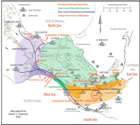
Alma 22:32 …it was only the distance of a day and a half’s journey for a Nephite, on the line Bountiful and the land Desolation, from the east to the west sea… [Bountiful and Desolation bordered on the west sea. There was a definite line between lands Bountiful and Desolation and that line started on the west sea and went easterly a day and a half. The Allens suggest 12 miles from Paredon to the Sierra Madre Mountains as this line, at page 412].
Alma 22:31 …The land on the northward [from the line] was called Desolation, and the land on the southward from the line] was called Bountiful, it [Bountiful] being the wilderness which is filled with all manner of wild animals of every kind, a part of which had come from the land northward [through Desolation] for food. [The term “land on the northward” is not referring to the greater land northward and the term “on the southward” is not referring to the greater land southward. Clearly all of the land southward was not the wilderness that “is filled with all manner of wild animals of every kind”. These “wild animals of every kind” were limited to the land Bountiful that was south of the line. Apparently some of the animals came from the land northward through land Desolation into the land Bountiful].
Ether 9:30 “…There began to be a great dearth upon the land…for there was no rain upon the face of the earth. [This is referring to the land northward including Desolation, otherwise there would have been no need to go into the land Bountiful”.]
31. …Their flocks began to flee before the poisonous serpents, towards [this is directional and not “in” yet] the land southward, which was called by the Nephites Zarahemla. [Why? Because there was rain in the land Bountiful along the west sea coast. From Esquintla, Guatemala to Tonala, Mexico and west of the Sierra Madre Mountains is one of the most productive areas with the highest rainfall. Even today when other areas have no rain this area, because of the high mountains, gets a lot more moisture.
32. …nevertheless, there were some [flocks or animals] which fled into [now they entered into] the land southward [bountiful]. [How far the animals went into the land southward we cannot tell but in order to get into the land southward they had to go through Bountiful, so therefore, when they “fled into the land southward” they went into Bountiful and not Hermounts].
Ether 10: 19 …in the days of Lib the poisonous serpents were destroyed. Wherefore they did go into the land southward [Bountiful], to hunt food for the people of the land for the land [Bountiful] was covered with animals of the forest. And Lib himself became a great hunter.
[Remember the “land on the southward” was called Bountiful. This could not have been Hermounts because Hermounts was uninhabited and infested, not with animal of all kinds of the forest, but with wild and ferocious beasts].
20. And they [the Jaredites loyal to King Lib] built a great city by [not in] the narrow neck of land [leading into the land southward], by [not in] the place where the sea divides the land. [Because the land southward was preserved for securing game means that the city of “Lib” was located north of the line in the land Desolation].
21. And they did preserve the land southward [bountiful] for a wilderness to get game. And the whole face of the land northward was covered with inhabitants.
22. …and they did buy and sell and traffic one with another that they might get gain.
So why did they build city “Lib” where they built the city Lib? To preserve the land Bountiful for themselves and keep others with whom they were trafficking for profit out of their “private and commercial hunting ground”. I submit that if this hunting area would have been in Hermounts, then anyone could have gone into those mountains (the mountains of Tehuantepec) from several areas and it would have been most difficult to defend. Further it would have been impossible for the people living in the coastal island city of La Venta (some 50 miles away) to have been able to defend anything except, perhaps, fishing in the Gulf.
By locating Lib “by” (not in) the narrow neck leading into the land southward, by the place where the sea divides the land and near the defensive wall at Horcones (which means large picket fence), the area southward would have been relatively easy to defend from hunters coming from the northward (because of the narrowness of the passage dividing Desolation from Bountiful) or from the eastward ( because of the very high and rugged Sierra Madre Mountains).
It seems to me that the reason why the oldest of all the early pre-classic cultures lived in the area of the west sea coast from Oaxaca down past La Democracia in Guatemala was because this lush area had more rain more consistently than any other area. This area even today (except for a small area between Juchitan and Tonala) is scarcely dry even in the dry season. Some scholars suggest that even the Olmecs could have come from the older Monte Alto culture which had settled along the Pacific Coast, (see Guatemala: From Violent History to Democratic Peace, by Raquel B. Tejeda, October 2009.)
3. More evidence that city of Lib was on or near the pacific coast and not on the Gulf Coast
Logic, reason and military expediency require that the city of Lib could not have been located on an island in the middle of a swampy area on the Gulf coast. Let’s look at other evidence and reason to see if it could have been reasonable to have located city of “Lib” at la Venta by answering the following questions (questions in black and responses in red):
1. What was the purpose of establishing a new city by King Lib? To facilitate securing food from the land southward (Bountiful) and to protect and preserve the land south of the “line” for this purpose.
2. Where was king Lib living or ruling from when he became a great hunter and when he established this new city? He was living in Moron which was located near (not in) Desolation and Desolation was located near the “west” sea (the Pacific) within the general area of the Isthmus of Tehuantepec. Therefore, according to the Book of Mormon, Moron had to have been “up” from Desolation but not “in” the land Desolation.
3. Why would King Lib, if he were living near Desolation near the Pacific Coast, build a new city at La Venta on the other side of the Isthmus on an island and in a swampy area? I do not believe he did.
4. If, as Ted Stoddard maintains, the “only reasonable route into the land southward” was along the Pacific Coast, then why would king Lib build his new city on the Gulf Coast in an area most inaccessible to the land southward?
5. City of “Lib” was also built “by”, (not in), the “narrow neck of land”. If “Lib” was at La Venta, where was the narrow neck of land? If the “narrow neck of land” was the whole of the isthmus then La Venta was part of it and “within” the narrow neck of land rather than “by it”. If it was not in the narrow neck of land then which side of the narrow neck of land was La Venta located?, This question , of course, invites the further question of just where were the boundaries of this “definable?” narrow neck of land? Where in the Book of Mormon does it say that the “narrow neck of land” went from a sea to a sea? (It doesn’t).
6. If La Venta was city of “Lib” then where did king Lib go from La Venta into the land southward for animal food? Was it Hermounts about 50 miles southward or was it eastward into the Tabasco area? (I submit neither).
7. If King Lib lived in or near the valley of Oaxaca then why would he travel 200 miles and cross the huge Coatzacualcos River to La Venta and then 50 miles or more to Hermounts to hunt for food and then return via La Venta and back to Moron a round trip of about 500 miles? (I do not believe he did).
8. One of the reasons for establishing the city of Lib was to protect and preserve the land southward to get game. How could the placement of the city of Lib at La Venta in any way have helped to preserve the land southward for a wilderness to get game, when the major access into the land southward was along the Pacific corridor? How could the island city of La Venta have been any help in preserving the land southward?
9. From whom was king Lib protecting and preserving the land southward? (I submit that there were other people in the area who would have desired to hunt in that area and some of them might have been enemies of King Lib. Remember the whole of the land northward was covered with inhabitants. It seems to me that for much of the Jaredite period there were at least two kingdoms, one of which was centered at Moron and the other apparently somewhat northward from there and the northern kingdom could have included La Venta.)
10. “Lib” was built “by” (of course this reaffirms that “by” does not means “in”) the place where the sea (not a river and not a lake) divides the land. If La Venta was Lib then where was the place where the “sea divides the land”? [This cannot be where a river divides the land nor where the land divides the seas but where the sea (singular) and only one sea divided the land. Which sea was it that divided the land?] (See map attached) (Also see discussion below).
Where was the place where the “sea divides the land”?
The term “sea” in the Book of Mormon is never confused with “river” or “lake” and always refers to a very large body of water implying an ocean or perhaps salt water. When the term “water” is used as when Mormon said “nearly surrounded by water” or “land of many waters” it very well could have included rivers, lakes and seas. Therefore, when Mormon used the term “by the place where the sea divides the land”, he was clearly referring to one ocean dividing the land and not a river dividing the land. When the dead bodies were thrown into the river Sidon, Alma says that the river carried the bodies out into the sea corroborating that the terms “sea” and “river” were not mingled.
The Allens, among others, propose that the River Coatzacoalcos and the Gulf of Mexico together form the “obvious” place where the “sea divides the land” (at pages 669,462, &276). (Apparently I miss-interpreted what the Allens meant). I received the following Email on 11-18-10 wherein Dr. Allen clarified, stating:
We thank you for calling our attention to this paragraph because we DO NOT believe that the Gulf of Mexico and the Coatzacoalcos River together form the “place where the sea divides the land.” The word “obvious” in this paragraph is not intended to proclaim that the Coatzacoalcos River and the Gulf of Mexico together are the obvious location of the “place where the sea divides the land.” We were trying to convey the concept that the descriptions outlined in Ether 10:20 “obviously” refer to a gulf and an isthmus.
In summary, we do not believe that the Coatzacoalcos River is part of the Gulf of Mexico…. We would appreciate it if you would make it clear that we believe that the “place where the sea divides the land” is only the Gulf of Mexico as reflected on our maps in figures 11-5, 19-12, 23-23, 26-1, 26-3, 26-22, as well as in other statements in Exploring the Lands of the Book of Mormon.
I appreciate Dr. Allen’s clarification and comments, however, with all due respect, that only makes it more improbable that city Desolation or city Lib could have been located on the Gulf of Mexico coastal area. If the Coatzacoalcos River could be construed to be part of the Gulf Sea, then one might be justified in claiming that city Desolation might have been located on a river 30 miles inland and throwing dead bodies into the river would be the same as throwing them into the sea.
I do not believe the Book of Mormon allows for such a construction. I do not believe the Nephites would have carried “great numbers” of Lamanites, killed at the city Desolation (San Lorenzo), some 30 miles, and dumped them into the Gulf “sea” especially when they could have carried them a mile or so to the Coatzacualcos.River.
Dr. Richard Hauck describes the term “the place where the sea divides the land” this way:
The term “divide”, means to split an entity into two or more parts. Now if one were to say, ‘the place where the land divides the sea’, one would accurately describe an isthmus. This is because the land or isthmus actually splits apart or divides the flanking sea shores. However, using the opposite term, “the place where the sea divides the land,” can only be indicative of two land surfaces split apart or divided by a sea.
I do not see how anyone living during Book of Mormon times, without the aid of some aerial survey, could have determined that it was the Gulf of Mexico that was dividing the land. Any one standing on the beach of the Gulf of Mexico could not have determined that the coast was anything but straight for as far as the eye could have seen. In fact if one were to choose which ocean Ether 10:20 was talking about it would have been more understandable to have chosen the Gulf of Tehuantepec because this Gulf more deeply cuts into the land than the Gulf of Mexico. I do not believe It was either gulf that divided the land.
Looking at a map of the western coast of Central America there is a series of long “narrow” lagoons and estuaries formed by the Pacific Ocean that separate the mainland of the Pacific coastal corridor from a long and narrow land tied to the mainland in a few places. This is the area where the Pacific Ocean divides the mainland from itself and extends (about75 miles) from the southern coast of Tehuantepec to just past the Tonala, Mexico area. This is a much preferable location for the place where the sea divides the land. It is also more logical to believe that Hagoth built his ships and launched them from one of these lagoons
It just happens that this is also the area where there is a great deal of evidence of many pre-classic cities and of a defensive area including a man made wall (also pre-classic ,at Horcones). This defensive area extends from the Pacific coast to the Sierra Madres Mountains to the east, forming an ancient defensive area about 20 miles across. This is the area believed by Dr Richard Hauck and me to be the following:
1. The “line” between Desolation and Bountiful on the west sea; Alma 22:32.
2. The area of the demarcation line of the treaty of AD 350; Mormon Mormon 2:28-29.
3. The area where Hagoth built and launched his ships into the west sea; Alma 63:5.
4. The place where Teancum headed the people of Morianton “by the sea on the west”: Alma 50:34.
5. The place where Moronihah defended, ”… the line [one day’s distance from the west sea] which they had fortified and stationed their armies to defend their north country:” Helaman 4:7.
It makes no rational sense to me that La Venta, much less San Lorenzo, could have been the city of Lib.
As stated above, if we are going to guess at the time periods of the genealogies and or generations of the Jaredites, then much better to start from the end of the Jaredites about 300 BC as shown in the Book of Mormon, give or take 50 years or so, and then go back the approximately 12 “generations” to king Lib. This would place the date of the city “Lib” not earlier than 1000 BC and not later than 700 BC. This would preclude both La Venta and San Lorenzo from being the city of Lib because both were in existence by 1200 BC. It also confirms that city Lib and city Desolation were much more likely built on the pacific side of the Tehuantepec area. Again this would exclude the more ancient area of Oaxaca. The area around the valley of Oaxaca (if that was Moron) would have been within the land northward and outside the land of Desolation, except to the extent that land Desolation was a small part of the greater land northward.
La Venta on the Gulf coast could not have been effective in protecting and preserving the “hunting grounds” of King Lib even if those hunting grounds were located in Hermounts. La Venta could only have helped to protect and preserve fishing in the Gulf.
I further submit that the description of the location of city Lib is almost the same as the description of the city of Desolation and if they were not the same city then they would at least have been sister cities but of a different time period inasmuch as city Desolation was built or rebuilt about AD 350 and Lib was built new about 800- 900 BC. Both of them were located “by” but not “in” the narrow pass (neck of land) leading into the land southward, meaning that both cities were located north of the “line” between bountiful and Desolation and certainly not near the Gulf of Mexico. Both cities were also located by the “place where the sea divides the land” on the Pacific side of Tehuantepec.
A final note regarding the “line”, the “treaty line”, “line bountiful/desolation”, and the west sea.
It is interesting to place all the scriptures dealing with the “line” between Desolation and west sea Bountiful together in the Book of Mormon sequence. To me it makes it very clear that all of the following scriptures are talking about the same “line” and area on or very near the Pacific Coast.
There was also an east sea land bountiful where City Bountiful was located but the following scriptures are not talking about the east sea land bountiful because they are always referencing the “line”, or the “line bountiful/desolation, or the west sea.
(About 85 BC) Alma 22:32 states “…it was only the distance of a day and a half’s journey for a Nephite, on the line Bountiful and the land Desolation, from the east to the west sea…” Desolation and Bountiful must border the west sea and the line between them must run from the west sea eastward. Also remember that none of the Nephite cities on the east sea coast except perhaps, Antionum, land and city of the Zoramites, had been established yet. Therefore, there had not been designated an east sea land bountiful or city bountiful until Moroni chased the Lamanites out of the east sea area in the year 72 BC and then sent Nephites to the east sea to build many new cities (see Alma 50).
(About 85 BC} Alma 22:31 states “...the land on the northward [of the line] was called Desolation, and the land on the southward [of the line] was called Bountiful, it being the wilderness which is filled with all manner of wild animals of every kind a part of which had come from the land northward for food.
It was this west sea Bountiful where King Lib hunted for wild animals and not in Hermounts. Notice also that the term “Land on the northward” is used differently that the term “the land northward”
(BC Alma 50:34) talking about Teancum heading the people of Morianton, states “…they did not head them until they had come to [not in] the borders of the land Desolation; and there they did head them, by [not in] the narrow pass which led by the [west] sea into the land northward, yea by the sea on the west
…” They were headed by the west sea within the narrow pass leading into the land southward and very near but south of the “line” between Desolation and Bountiful). They were headed in the west sea land Bountiful. I do not see how the armies of Teancum and Morianton could have traveled through the most inaccessible part of the Peten and Yucatan and Tabasco areas crossing the Usumacinta delta and the Coatzacualcos River to arrive at Desolation (San Lorenzo) each army traveling a different route. Each army would have had to have also passed through the humongous area of the Mirador basin with its hundreds of thousands of people. Ted Stoddard maintains that the “only reasonable route” to the land northward was through the west sea area and then through the Isthmus of Tehuantepec.
(About 55 BC) Alma 63:5 states “…Hagoth, he being an exceedingly curious man, therefore he went forth and built him an exceedingly large ship, on [in] the borders of the land Bountiful, by [not in] the land Desolation, and launched it forth into the west sea, by [not in] the narrow neck [same as pass or passage] which led into the land northward”. (He launched the ships from west sea land Bountiful and very close to but south of the “line”. I submit that if Hagoth launched his ships into the Pacific Ocean then the land bountiful and the land and city of Desolation and the line between them must also be located by that same west sea and not on the Gulf of Mexico.)
(About 35 BC) Helaman 4:5-8 talking about when dissident Nephites stirred up the Lamanites and they came down to Zarahemla and “…they succeeded in obtaining possession of the land of Zarahemla; yea, and also all the lands, even unto [notice the term “unto” does not mean” in”] the land which was near the land Bountiful. 6. And the Nephites and the armies of Moronihah [son of Moroni] were driven even into [now they go into] the land Bountiful. 7. And there they did fortify against the Lamanites, from the west sea [land Bountiful must be on the west sea] even unto the east (this is not the east sea); it being a day’s journey for a Nephite, on the line which they had fortified and stationed their armies to defend their north country. [They stationed their army all across this 20 miles or so line from the east to the west sea] 8. And thus the dissenters of the Nephites, with the help of a numerous army of the Lamanites, had obtained all the possession of the Nephites which was in the land southward….” They clearly located by the west sea. Either there was a second “line” that was just southerly from the “Line Desolation/Bountiful” and within the west sea land Bountiful, or this was the same “line” and the army was stationed right on it because the Lamanites now controlled all of the Nephite lands southward. Clearly they were protecting their “new” north country because since about 55 BC many large groups of Nephites had been migrating into the lands northward. Certainly from the “line” to the “north” would have been the land northward towards where the hill Cumorah was located.
(About AD 16) 3 Nephi 3; is talking of when the Nephites desired to go up after the Gadianton Robbers who resided in all the mountains and wilderness, however, Lachoneus, instead had them abandon all their cities and places of residence in the areas surrounding Zarahemla. Tens of thousands moved all their food, livestock etc. and moved to the area of the “line” Bountiful/Desolation. “…the land which was appointed was the land of Zarahemla, and the land which was between the land Zarahemla and the land Bountiful, yea, to [not beyond] the line which was between the land Bountiful and the land Desolation. …Lachoneus did cause that they should gather themselves together in the land southward, because of the great curse which was upon the land northward.”
Clearly they settled in that part of the greater land of Zarahemla that was called Bountiful from the “Line” and southward as needed because they settled in one place. An excellent candidate for this location is the huge and once heavily populated area called La Perseverancia located just southward from the “line”. (The description of this site and its population is according to Gareth Lowe; Izapa: An introduction to the Ruins and Monuments, 1982).
(About AD 327) Mormon2:5 & 6 talking about after the Nephites were chased out of Zarahemla and Angola for the last time with their families and possessions to the west sea bountiful area at the land of Joshua. “5. And they did also drive us forth out of the land of David. 6. And we marched forth and came to the land of Joshua, which was in the borders west by the seashore”. I submit that “west by the seashore cannot mean anywhere on the Gulf of Mexico. Even though Joshua was located substantially southward of Desolation, it was probably located at the southern extremes of the west sea land bountiful and, therefore, I have included it here. Clearly the cities of David and Angola were located between Zarahemla and the west coast where Joshua was located and, therefore, these three cities could not have been located on or near the Gulf coast of Mexico.
(About AD 350) Mormon 2:29 states “And the Lamanites did give unto us the land northward, yea, even to [not in] the narrow passage which led into the land southward. And we did give unto the Lamanites all the land southward” [of the “treaty line” between Desolation and Bountiful including the narrow passage leading into the land southward].
(About AD 360) Mormon 3:5 states “[Mormon caused that they should]…gather themselves together at the land Desolation, to a city [Desolation] which was in the borders, by [not in] the narrow pass which led into the land southward.”
To me the term “at the land Desolation, to the city [Desolation]” means that the land Desolation was not synonymous with the greater land northward but was a small subdivision thereof. Many times in the Book of Mormon the term “Land of” means the land immediately surrounding the named city.
(About 900 BC) Ether10:19-21 states.”…they did go into the land southward, to hunt food for the people of the land…and they built a great city by [not in] the narrow neck of land, [leading into the land southward] by the place where the sea divides the land. …they did preserve the land southward for a wilderness, to get game”. City of Lib was located within the narrow pass that led into the land northward and very close to the “line” from whence began the narrow pass that led into the land southward. Lib was also located near the area where the sea (singular) divided the land (as explained above).
In my opinion there is nothing in these scriptures giving any reasonable credibility to the belief that the cities of Desolation and Lib could have been located anywhere near the Gulf Coast of Mexico. I submit that none of the named Nephite Book of Mormon cities, except some of those mentioned in Ether, (excluding Lib and Desolation and Cumorah) could have been located near the Gulf Coast. More on this topic will be discussed in a later article.
Also it seems to me that because the land of Desolation “came into the land which had been peopled and destroyed” (the land northward) that the land Desolation was but a small part of the land Northward. This seems to be confirmed by the fact that the first and last capital of the Jaredites at Moron was not located in Desolation but near it. Where was the place where the land Desolation became the land northward? I submit that it was the narrow pass within the Isthmus of Tehuantepec. See map above.