


Book of Mormon Geography and the Book of Ether
The book of Ether gives us several geographical pointers that we can use in helping to identify the Book of Mormon’s hill Ramah/Cumorah and hill Shim. Using these pointers in conjunction with three-dimensional imagery from Google Earth, Dr. Poulsen has identified the territory of the Misantla basin in Veracruz, Mexico, as a possible candidate for Ramah/Cumorah and Shim. Book of Mormon readers and scholars are invited to evaluate the Misantla proposal—especially if they will master the Google Earth software well enough to verify the validity of Dr. Poulsen’s proposal.
By the time we get to the book of Ether while reading the Book of Mormon, our eyes are tired, and we seem to skip over many of the small details and make unwarranted assumptions. This is particularly true of those details related to our understanding of the geographical setting of the Jaredite culture. Although only a few verses in Ether contain geographical information, these verses are of extreme importance to our understanding of the relationships between the Jaredite and the Nephite-Lamanite cultures.
As has been emphasized by many students of Book of Mormon geography, the Book of Mormon is not a geography textbook. Most of the information about geography is evident only after careful examination of the textual context. This is especially true of the book of Ether. Although Mormon made an abridgement of the Nephite records, Moroni’s account of the Jaredites is more of an abstract with commentary rather than an abridgment.
Moroni begins his abstract of the twenty-four plates of Ether as follows:
And now I, Moroni, proceed to give an account of those ancient inhabitants who were destroyed by the hand of the Lord upon the face of this north country.
And I take mine account from the twenty and four plates which were found by the people of Limhi, which is called the Book of Ether.
And as I suppose that the first part of this record, which speaks concerning the creation of the world, and also of Adam, and an account from that time even to the great tower, and whatsoever things transpired among the children of men until that time, is had among the Jews—
Therefore I do not write those things which transpired from the days of Adam until that time; but they are had upon the plates; and whoso findeth them, the same will have power that he may get the full account.
But behold, I give not the full account, but a part of the account I give, from the tower down until they were destroyed. (Ether 1:1–5; emphasis added)
Moroni casually tells us that this is a record of the inhabitants of “this north Country” who were destroyed. He also informs us that it is a limited account that covers only the period beginning at the Tower of Babel and finishing with the last battle. Moroni reiterates this limitation by saying, “And the Lord spake unto Ether, and said unto him: Go forth. And he went forth, and beheld that the words of the Lord had all been fulfilled; and he finished his record; (and the hundredth part I have not written) and he hid them in a manner that the people of Limhi did find them” (Ether 15:33).
To interpret the meaning of the phrase “in this north country,” we must examine where Moroni was located while working on the material contained in the twenty-four plates of Ether.
Having finished the record of his father, Moroni informs us in Mormon 8:1 that he still has more to write but that he has room on the plates to write only what his father has commanded him to write. He then says:
Therefore I will write and hide up the records in the earth; and whither I go it mattereth not.
Behold, my father hath made this record, and he hath written the intent thereof. And behold, I would write it also if I had room upon the plates, but I have not; and ore I have none, for I am alone. My father hath been slain in battle, and all my kinsfolk, and I have not friends nor whither to go; and how long the Lord will suffer that I may live I know not.
Behold, four hundred years have passed away since the coming of our Lord and Savior. (Mormon 8:4–6)
Verse 6 tells us that fifteen years have passed since the battle at Ramah/Cumorah. Very likely, Moroni would not have remained long in that Lamanite-controlled vicinity out of fear of being caught and killed. Between AD 385 and AD 421, Moroni traveled from Ramah/Cumorah to Cumorah/New York where the plates were buried and hidden up for Joseph Smith to find. After the battle at the hill Ramah/Cumorah, we can reasonably conclude that Moroni at any given time could be found somewhere between Ramah/Cumorah and Cumorah/New York as he journeyed toward the place where Joseph Smith was destined to receive the plates. Based on this conclusion, “this north country,” the land of the Jaredites, was in all likelihood somewhere north of the land Ramah/Cumorah.
Our next bit of information is found in the ninth chapter of Ether:
And the Lord warned Omer in a dream that he should depart out of the land; wherefore Omer departed out of the land with his family, and traveled many days, and came over and passed by the hill of Shim, and came over by the place where the Nephites were destroyed, and from thence eastward, and came to a place which was called Ablom, by the seashore, and there he pitched his tent, and also his sons and his daughters, and all his household, save it were Jared and his family. (Ether 9:3)
Omer departed out of the land of his inheritance, probably near the center of the land of the Jaredites, traveled many days in an unspecified direction, passed by the hill Shim and then the hill Ramah/Cumorah, and then traveled eastward to the seashore where he took up residence. Omer’s goal is the seashore, and it is Moroni who informs us of the name Shim and the nature of the hills relative to the last battles of the Jaredites and Nephites, neither of which has yet taken place. Apparently, the land of Omer’s first inheritance was many days removed from the land of Cumorah and somewhere to the north and west of that land. Moroni does not give us enough information to know whether the land of Ramah/Cumorah was another part of the land of the Jaredites or merely under Jaredite control, but if it was either of these, then the lands of the Jaredites comprised an extensive territory. However, communication must have occurred between these two areas because when conditions changed in Omer’s land of inheritance, he was notified and restored to his throne.
The westward location of the land of the Jaredites is confirmed by the scripture that records Ether’s account of the first phase of the battles between Coriantumr and Shiz:
And it came to pass that Shiz did pursue Coriantumr eastward, even to the borders by the seashore, and there he gave battle unto Shiz for the space of three days. (Ether 14:26)
Three more locations are described in the story of the culminating battles between Coriantumr and Shiz.
And it came to pass that he came to the waters of Ripliancum, which, by interpretation, is large, or to exceed all; wherefore, when they came to these waters they pitched their tents; and Shiz also pitched his tents near unto them; and therefore on the morrow they did come to battle.
And it came to pass that they fought an exceedingly sore battle, in which Coriantumr was wounded again, and he fainted with the loss of blood.
And it came to pass that the armies of Coriantumr did press upon the armies of Shiz that they beat them, that they caused them to flee before them; and they did flee southward, and did pitch their tents in a place which was called Ogath.
And it came to pass that the army of Coriantumr did pitch their tents by the hill Ramah; and it was that same hill where my father Mormon did hide up the records unto the Lord, which were sacred. (Ether 15:8–11)
The word Ripliancum is interpreted by Moroni as “large, or to exceed all,” and Moroni informs us that the hill Ramah is the same location as the hill Cumorah where Mormon hid the Nephite records—in other words, the site of the last battle of the Nephites where the Nephite culture was destroyed.
We can interpret the meaning of Ripliancum in two ways. First, possibly this is the name given to the sea bordering on the seashore mentioned in the above verses. Second, however, although we have no way of knowing whether Ripliancum is singular or plural; the use of waters suggests that this location has multiple forms of water, some of which are large and others that are larger than those known to Moroni or the Jaredites. Either or both meanings are possible.
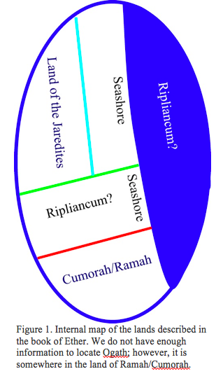
Do we have enough information to build an internal map of the locations described in the Book of Ether? So far we have the information in the following list:
1. The Jaredites were principally located west of the seashore. Except for the possibility that the sea is called Ripliancum, no name is given to the sea in question.
2. Ramah/Cumorah is west of a seashore.
3. The waters of Ripliancum are north of the land of Ramah/Cumorah.
4. Ripliancum is interpreted by Moroni as large, or to exceed all.
5. The land of the Jaredites where Omer had his kingdom is many days removed from the land of Ramah/Cumorah.
6. The land of the Jaredites is in the north country somewhere along the route Moroni traveled to get to Cumorah/New York.
7. Although multiple seashores are possible, based on the hypothesis that the Book of Mormon lands are somewhere in Mesoamerica, we can reasonably assume a single extended seashore.
Based on this information, the internal map shown in figure 1 was constructed.
Using this internal map, we can hypothesize a real-world location for the land of Ramah/Cumorah and the adjoining land of the Jaredites. Our first step is to select an anchor point and then test the validity of surrounding real-world geographic features in relationship to the anchor point based on our internal map. In other words, do the real-world features in our hypothetical location fit the constraints imposed by our internal map? Based on the list above, two candidates are possible for an anchor point. One is the seashore, and the other is the hill Shim-hill Ramah/Cumorah pair of mountains. Because seashores can be very extended, the obvious choice is the pair of mountains. The need to have them in close proximity and still isolated from each other places somewhat stringent geographic conditions that should result in a minimum of possibilities in the real world.
Using the criteria listed above, the Google Earth three-dimensional mapping program, and the hypothesis that Book of Mormon lands are located in Mesoamerica, I made a search of the eastern seashores of the Caribbean Sea and the Gulf of Mexico. Four possible locations were found at the following locations:
1. Belize proposal: East seashore on the southern coast of Belize, lat 16.986, lon 88.488, 2,000–3,000 feet high,
2. Vigia proposal: Northern seashore of the Gulf of Mexico, lat 18.436, lon 98.183, 2,500 feet high.
3. Misantla proposal: Eastern seashore of the Gulf of Mexico, lat 20.057, lon 96.870, 2,000 feet high.
4. Tepetzintla proposal: Eastern seashore of the Gulf of Mexico, lat 21.257, lon 97.879, 3,600 feet high.
The Belize proposal consists of two peaks in a small mountain range in Belize and was not investigated further.
The Vigia proposal and the Tepetzintla proposal have both been previously suggested as possible locations for the land of Ramah/Cumorah. They both have a location called “Maize Mountain” and a nearby hill that qualifies as Ramah/Cumorah. The Vigia proposal was suggested initially by David Palmer on the basis that the name of the eastern hill, Cintepec, means “Maize Mountain” in Nahuatl and that the word shim is almost the same as the Mayan word for corn—ixim, pronounced eesheem. I suggested the Tepetzintla proposal by using a similar rationale because the town near the mountain is called Tepetzintla, which also translates to “Maize Mountain.” The Misantla proposal has not previously been described or suggested as the land of Ramah/Cumorah and was, therefore, selected for further investigation.
To evaluate these possibilities, we need a geographic description of the land of Ramah/Cumorah and surrounding areas based only on the text found in the Book of Mormon. A search of the text provides the following verses that contain geographic information related to the land of Ramah/Cumorah:
And about the time that Ammaron hid up the records unto the Lord, he came unto me, (I being about ten years of age, and I began to be learned somewhat after the manner of the learning of my people) and Ammaron said unto me: I perceive that thou art a sober child, and art quick to observe;
Therefore, when ye are about twenty and four years old I would that ye should remember the things that ye have observed concerning this people; and when ye are of that age go to the land Antum, unto a hill which shall be called Shim; and there have I deposited unto the Lord all the sacred engravings concerning this people.
And behold, ye shall take the plates of Nephi unto yourself, and the remainder shall ye leave in the place where they are; and ye shall engrave on the plates of Nephi all the things that ye have observed concerning this people.
And I, Mormon, being a descendant of Nephi, (and my father’s name was Mormon) I remembered the things which Ammaron commanded me.
And it came to pass that I, being eleven years old, was carried by my father into the land southward, even to the land of Zarahemla. (Mormon 1:2–6; emphasis added)
And the three hundred and forty and ninth year had passed away. And in the three hundred and fiftieth year we made a treaty with the Lamanites and the robbers of Gadianton, in which we did get the lands of our inheritance divided.
And the Lamanites did give unto us the land northward, yea, even to the narrow passage which led into the land southward. And we did give unto the Lamanites all the land southward. (Mormon 2:28–29; emphasis added)
And now I finish my record concerning the destruction of my people, the Nephites. And it came to pass that we did march forth before the Lamanites.
And I, Mormon, wrote an epistle unto the king of the Lamanites, and desired of him that he would grant unto us that we might gather together our people unto the land of Cumorah, by a hill which was called Cumorah, and there we could give them battle.
And it came to pass that the king of the Lamanites did grant unto me the thing which I desired.
And it came to pass that we did march forth to the land of Cumorah, and we did pitch our tents round about the hill Cumorah; and it was in a land of many waters, rivers, and fountains; and here we had hope to gain advantage over the Lamanites. (Mormon 6:1–4; emphasis added)
And now I, Moroni, proceed with my record. Therefore, behold, it came to pass that because of the secret combinations of Akish and his friends, behold, they did overthrow the kingdom of Omer.
Nevertheless, the Lord was merciful unto Omer, and also to his sons and to his daughters who did not seek his destruction.
And the Lord warned Omer in a dream that he should depart out of the land; wherefore Omer departed out of the land with his family, and traveled many days, and came over and passed by the hill of Shim, and came over by the place where the Nephites were destroyed, and from thence eastward, and came to a place which was called Ablom, by the seashore, and there he pitched his tent, and also his sons and his daughters, and all his household, save it were Jared and his family. (Ether 9:1–3; emphasis added)
And when Coriantumr saw that he was about to fall he fled again before the people of Shiz.
And it came to pass that he came to the waters of Ripliancum, which, by interpretation, is large, or to exceed all; wherefore, when they came to these waters they pitched their tents; and Shiz also pitched his tents near unto them; and therefore on the morrow they did come to battle.
And it came to pass that they fought an exceedingly sore battle, in which Coriantumr was wounded again, and he fainted with the loss of blood.
And it came to pass that the armies of Coriantumr did press upon the armies of Shiz that they beat them, that they caused them to flee before them; and they did flee southward, and did pitch their tents in a place which was called Ogath.
And it came to pass that the army of Coriantumr did pitch their tents by the hill Ramah; and it was that same hill where my father Mormon did hide up the records unto the Lord, which were sacred. (Ether 15:7–11; emphasis added)
The following list, extracted from the words bolded in the above scriptures, describes the land of Ramah/Cumorah and can be compared to the proposed candidates:
2. It is located in the land northward in a place where Mormon resided as a child.
3. It is not part of the land of Zarahemla.
4. The hill Shim and the hill Ramah/Cumorah are located near each other in this locality.
5 The land of Omer’s first inheritance and center of Jaredite lands is many days’ journey from this land.
6. It is south of the borders of the waters of Ripliancum.
7. The hill Ramah/Cumorah is east of the hill Shim.
The area around location two, the Vigia proposal, has been extensively described by Palmer, Sorenson, and Joseph and Blake Allen. With the exception of requirement six (the anomalous directional relationship between the proposed hill Shim and Ramah/Cumorah), it is a reasonable fit to the data.
Location four, the Tepetzintla proposal, appears to meet requirements two through four, but we do not have enough information to evaluate fully the remaining requirements. It appears to be too far north to qualify as the land of Moroni’s youth.
Even less easily found information about location number one, the Belize proposal, is available, and it was not investigated further.
Although location number three, the Misantla proposal, has never been proposed as the land of Ramah/Cumorah, extensive information is available for this area. The majority of this information is available only in Spanish, and this may be one of the reasons for its remaining in obscurity. Fortunately, the Viceroy of Mexico, shortly after the Spanish conquest, required that a report be submitted answering fifty questions about all locations still inhabited by Mesoamerican language groups. These reports are called relaciones and are filed in the various archives throughout Mexico and in the Royal Archives in Spain.
Information about location three, the Misantla proposal, is found in the Relacion de Misantla prepared by Diego Perez de Arteaga and presumably was never submitted to the Royal Archives. It was eventually sold, along with other “relaciones” from Veracruz, to the University of Texas at Austin for $10,000.
After acquiring copies of the Relacion de Misantla, David Ramirez Lavoignet prepared a revision of the relacion and, after adding extensive notes to bring it up to date, published it in 1962.
Using the information in Lavoignet’s publication and that obtained from modern three-dimensional mapping programs in Google Earth, I made an evaluation of the Misantla proposal by comparing it with the seven textual requirements for the land of Ramah/Cumorah with the following results:
Beginning on page 70, the hydrographics of Misantla are described as follows: “Unos de los aspectos mas prominentes de la region de Misantla, es la abundancia de agua, pues es un distrito, humedo por naturaleza, donde jamas han existidos los problemas dificiles de otros lugares.
“En todo su jurisdiccion abunden manantiales, lagunas, y arroyos.Los grandes rios forman una verdadera red hydrographica, y es notable que aun en los cerros, se encuentran pequeños fuentes.”
A rough translation is the following: “One of the aspects most prominent of the region is the abundance of water; yes, it is a district, humid by nature, where never have existed the difficult problems of other places.
“In the entire jurisdiction, there are abundant springs, lagoons, and streams. The great rivers form a true hydrographic net, and it is notable that even in the hills, little fountains are found.”
Lavoignetcontinues by describing the sources and effects that this abundance of water has on the area and its inhabitants.
2. It is located in the land northward in a place where Mormon resided as a child.
Misantla is located about two hundred miles northwest of the northern end of the Isthmus of Tehuantepec, the generally accepted narrow neck of land that separated the land northward from the land southward in the Book of Mormon.
It is about four hundred miles northwest of the Grijalva River valley and Santa Rosa, proposed by Sorenson and others as the city of Zarahemla.
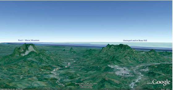
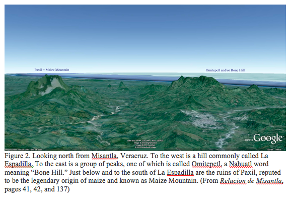
4. The hill Shim and the hill Ramah/Cumorah are located near each other in this locality. See figure 2.
5 The land of Omer’s first inheritance and center of Jaredite lands is many days’ journey from this land.
According to the text, the land of the Jaredites includes territory that is located inland in highlands west of the seashore. The highlands begin about a hundred miles inland from the gulf and extend hundreds of miles to the west.
6. It is south of the borders of the waters of Ripliancum.
Figure 3 is a hydrographic map of the Misantla basin. The area of multiple rivers and streams extends north to the Rio Remolino-Tecolutla and is described by Padre Motolinia during his travels through the area shortly after the Spanish conquest as “aunque quisieramos volver por otro camino, no podiamos, porque despues que entramos en aquella tierra, habia llovido mucho, y habian crecido los rios, que eran muchas y muy grandes: . . . Uno de estos rios es el que los espanoles llamaron Almeria (Nautla), el cual es un rio muy poderoso.”
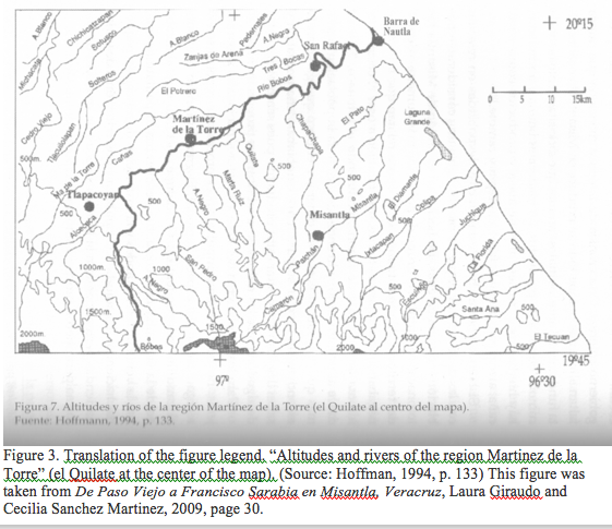
Figure 3. Translation of the figure legend. “Altitudes and rivers of the region Martinez de la Torre” (el Quilate at the center of the map). (Source: Hoffman, 1994, p. 133) This figure was taken from De Paso Viejo a Francisco Sarabia en Misantla, Veracruz, Laura Giraudo and Cecilia Sanchez Martinez, 2009, page 30.
See figure 2. The area surrounding the city of Misantla appears to fit the textual requirements in the Book of Mormon for the land of Ramah/Cumorah in every particular. It is in proper orientation with the eastern seashore and is supported by the traditional names for the peaks. Palmer and others assure us that the word shim is related to the word for maize or corn in the Mayan language. Brian Stross (personal communication) equates shim with iksi, the word for shelled corn in Mixe Zoque, and the Popul Vuh equates Paxil with Maize Mountain, the primeval source of maize.
It is interesting to speculate about why Moroni, speaking of the hill Shim, introduced it as “a hill which shall be called Shim.” Could it be because this hill as a repository of records would end up in legend as the place where the gods gave corn to man? As is well known, corn is indigenous to the Americas and has the unique characteristic that it cannot survive and propagate without the assistance of man. Could it have been this hill that contained the records of how the Jaredites obtained this gift from God that has so benefited not only ancient Americans but also the modern world? Think about it as you eat your corn flakes each morning.
When we consider the very important role that corn played in the cultures of ancient America and corn’s role as described in the Book of Mormon as an important crop grown in the land of Zarahemla, this correlation with the textual description of the geography strongly supports the proposal that the Misantla basin is an excellent candidate for the land of Ramah/Cumorah in the Book of Mormon.