


Book of Mormon Trifecta
Book of Mormon Trifecta
by Kirk Magleby
presented Saturday, October 18, 2014 at the 12th annual BMAF conference
In his blog Book of Mormon Resources, Kirk describes his presentation:
I presented a methodology for solving the Book of Mormon geography problem using the 2009 Yale edition to answer the question What does the text say?; the Oxford English Dictionary (OED) to answer the question What did this word or phrase mean in Early Modern English? and Google Earth to build and test correlation models. Assumptions provide an interpretive framework for textual exegesis. Criteria based on those assumptions itemize points any viable correlation should exhibit for a Book of Mormon place. I demonstrated the methodology with 16 assumptions about the text and 30 criteria for the narrow (small) neck of land. I tested two correlations 1) the Sorenson/Norman/Allen model where the narrow (small) neck of land is the Isthmus of Tehuantepec and 2) the Hauck/Andersen/Magleby model where the narrow (small) neck of land is Barra San Marcos on the coast of Chiapas near Tonala. The Isthmus of Tehuantepec correlation satisfies 10 of 30 textual + lexical criteria for a success rate of 33%. The Barra San Marcos correlation satisfies 30 of 30 criteria for 100%. I managed my allotted time poorly, so did not present any of the other 300+ criteria that have been developed to date or the 7 tests any viable correlation should pass. I was unable to go over the geographic features in the text whose correlations have proven convincing enough to make them candidates for consensus. I likewise had to skip 7 independent corroborations of the narrow (small) neck of land - Barra San Marcos correlation. I concluded with the idea that the Yale Edition, the OED and Google Earth enable reproducible results, and science advances based on reproducible results. This gives me hope we can solve the Book of Mormon geography conundrum soon. My 9 page lecture notes are here. My 91 slide powerpoint that partially illustrates the notes is here. The numbers in the upper right hand corner of each powerpoint slide correlate with the points and sub-points in the lecture notes.
The Book of Mormon went on sale to the public on March 26, 1830. As of today, It has now been available for: 67,412 days, 9,630 weeks, 2,214 months and 184 years. Isn’t it about time we figured out where the Book of Mormon narrative took place? I can’t think of anything that would do more to advance the cause of the Book of Mormon around the world.
The problem comes from widely divergent interpretations of the text. For example, John L. Sorenson interprets the entire passage of Alma 62:23-37 as occurring in a single 24 hour day. This reading allows him to cluster many lands and cities very tightly together. It also justifies his correlation of an east sea coast only about 1/3 the length of a west sea shoreline.
John L. Sorenson and most others make the assumption that the narrow neck of land = isthmus. Many people read Alma 22:32-33 and make the conjectural addition that “east” means “east sea”. This supports their assumption that narrow neck = isthmus. John L. Sorenson and many others read Ether 9:3 as referring to the east sea. This justifies the Gulf of Campeche as the east sea. John L. Sorenson reads Helaman 3:8 and suppresses the existence of the sea north and the sea south. He decides these two seas are “metaphorical” because they don’t fit his model. Rod Meldrum interprets Alma 43:32 such that Manti was down in elevation from the land of Jershon, making the river Sidon flow from north to south. This logical fallacy of taking a passage out of context results in a false attribution.
Many not of our faith are now taking the Book of Mormon seriously.
a. Oxford University Press, 2002
b. University of Illinois Press, 2003 (1920 LDS edition)
c. Doubleday Edition, 2004 (1981 LDS edition)
d. Penguin Classics Edition, 2008 (1840 Nauvoo edition)
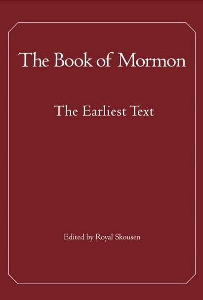
e. Yale University Press, 2009
f. Oxford University Press, 2009
g. Oxford University Press, 2010
h. Princeton University Press, 2012
6. We will solve the Book of Mormon geography problem when we take the text seriously enough to use the best tools available.
a. Yale edition (critical text) Assumptions
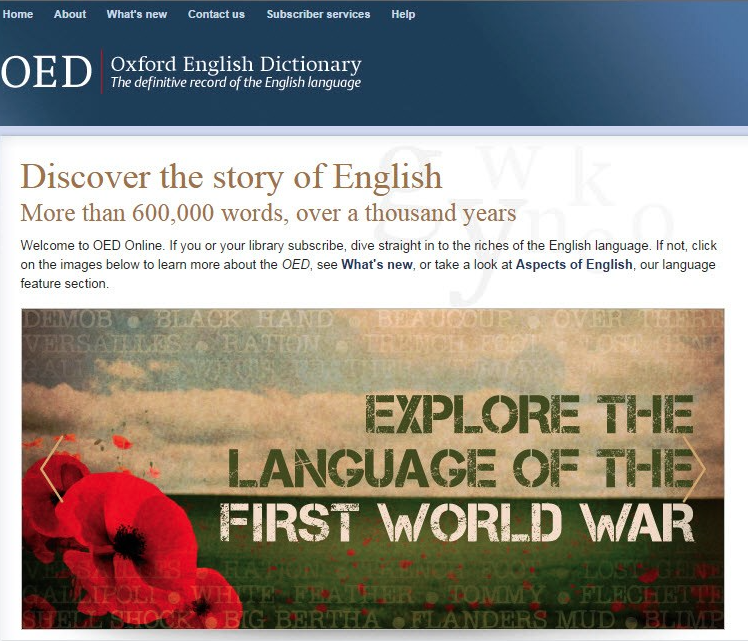
b. Oxford English Dictionary (OED) Criteria
c. Google Earth (GIS) Models & Tests
d. Archaeological Analyses Validation
7. The Yale edition answers the question What does the text say?
a. Alma 51:26 city of Nephihah sb city of Moroni
b. Alma 21:2 Amalekites (18 occurrences) sb Amlicites
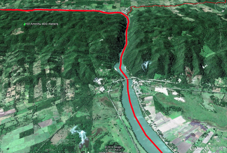
c. Alma 2:15 Amlicites came upon the hill Amnihu sb came up upon the hill Amnihu
d. Alma 24:5 land of Midian sb land of Middoni
8. In the course of his 25 year research odyssey, Royal Skousen came to 2 very important conclusions.
a. The translation process was under divine “tight control.”
b. The target language for the text was Early Modern English (1470 – 1700).
9. While Royal Skousen was a lone voice in the wilderness, many conveniently ignored him. Stanford Carmack is now a second witness of both divine tight control and Early Modern English.
10. So, we need to ask the question What did this word or phrase mean in Early Modern English? The OED answers the question What does the text mean?
a. A neck of land could be an isthmus, but generally it was a peninsula.
b. Narrow meant slender or constricted, with width much smaller than length.
c. Between meant “by twin” or “by twain.” A is separate from, adjacent to twins B & C.
d. Waters referred to the wave action of the sea, the rolling action of a river, or medicinal springs. Psalms 23:2 is almost always interpreted as a quiet stream.
e. The head of a river was the confluence of two or more tributary streams.
11. With the best edition of the text + the EModE meanings of the words and phrases, we can formulate assumptions – an interpretive framework.
a. The text is primary because it is closest to the divine. It trumps speculation by Joseph Smith or his associates, native American ethnohistory, current archaeological opinion, etc.
b. The language of the text is Early Modern English with its epicenter about 1560, pre-dating even the King James Version (1611).
i. Yea clauses explicate the subject in the previous clause.
c. Take the text at face value.
i. Up, down describe relative elevation.
ii. Directional cardinality.
d. Interpret the text consistently.
i. Same interpretive standards in the Old World & the New.
ii. All toponyms are physical.
iii. Avoid double defining a single toponym.
iv. Singular instances still apply.
v. A Nephite = member of the polity, any citizen or soldier
vi. Do not over emphasize one feature.
e. Analyze the text with precision in historical context.
i. Avoid forced readings.
ii. Avoid atextual assumptions.
iii. Avoid conjectural additions.
iv. Avoid false attributions.
v. Do not base conclusions on lacunae.
f. Account for all contextualized referents – no selective suppression, no proof texting.
g. Correlate space and time.
i. Alma 22 describes the geo-political situation ca. 90 B.C.
ii. The parallel text in Alma 50 describes the geo-political situation ca. 72 B.C.
h. Wilderness is territory beyond political control.
i. Neither Nephites nor Lamanites exercised exclusive sovereignty over their territory in the way a modern state does. These were strings of settlements with intervening wilderness.
j. Both Nephites and Lamanites were capable of projecting power and maintaining supply lines across space hundreds of kilometers distant from their respective capitals.
k. Follow the rivers.
l. Accept correlations that achieve viable consensus.
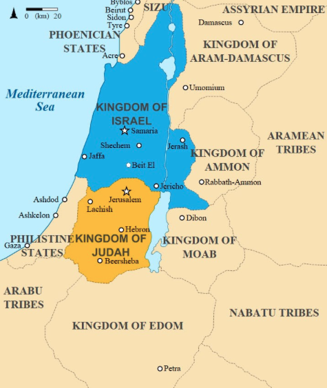
i. Old World
1. Jerusalem = Jerusalem
2. River Laman & Valley of Lemuel = Saudi Arabia along Gulf of Aqaba
3. Shazer = Saudi Arabia along Red Sea
4. Camp of Broken Bow = Saudi Arabia further south along Red Sea
5. Nahom = NHM, Yemen
6. Bountiful = Wadi Khayrfawt & Wadi Sayq, Oman
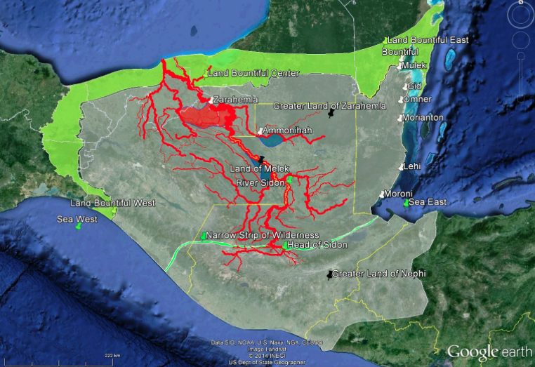
ii. Nephi = highland Guatemala
iii. Zarahemla is lower in elevation than Nephi
iv. River Sidon flowed generally south to north
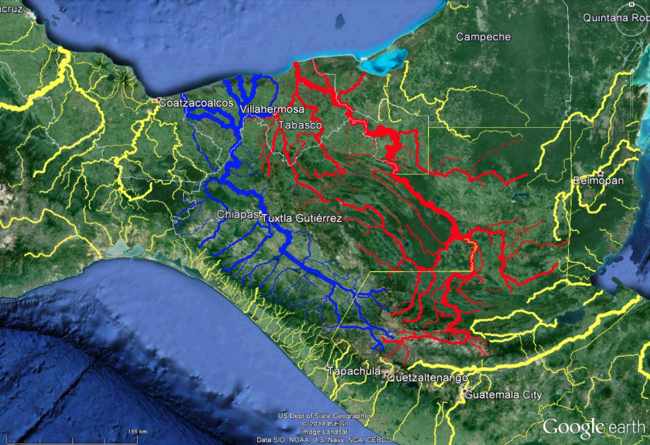
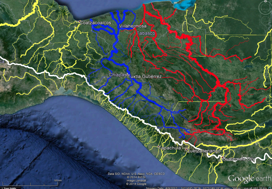
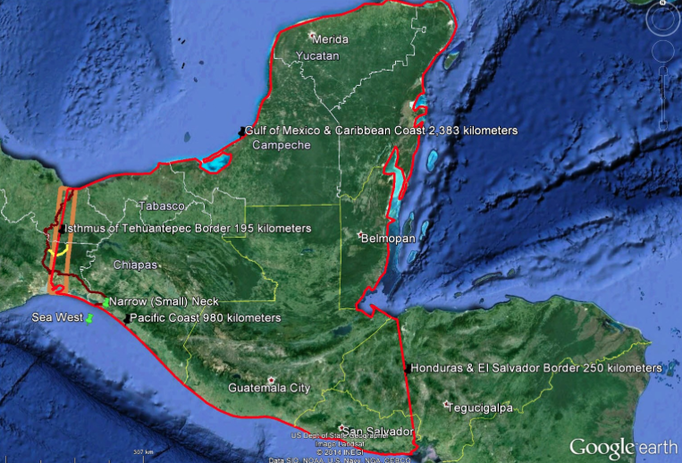
v. Cumorah = Tuxtla Mountains in southern Veracruz
vi. West sea = Pacific coast of Chiapas
vii. Land southward = Chiapas + Tabasco & points south
viii. Land northward = Most of Veracruz + Most of Oaxaca & points north
ix. Jaredite/Olmec relationship
m. Allow for multiple meanings in cases with textual support.
i. Bountiful
ii. Desolation
iii. Greater Nephi
iv. Greater Zarahemla
n. Lehi-Nephi was a politically correct term used only temporarily in the text.
o. Favor data-driven empiricism over subjectivity.
p. Deduce standards and limits from the text and external sources.
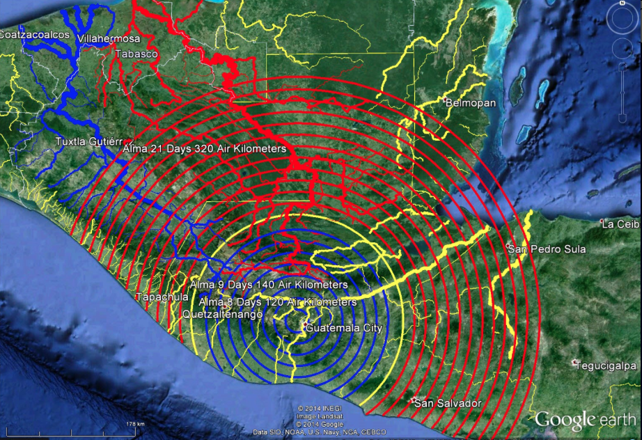
i. The standard Nephite unit of distance measure “one day’s journey” was approximately 15 air kilometers in length.
ii. A geographic feature called “narrow” or “small” did not exceed 20 kilometers in width and was highly likely not to exceed 5 kilometers in width.
iii. The term “near” meant two geographic features within 5 kilometers of each other. Features 5 – 8 kilometers proximate were “not far.” Features more than 400 kilometers distant were “far” from each other.
iv. The term “by” meant two geographic features likely to be contiguous with less than 25 kilometers separating them and a clear margin or littoral present.
q. The goal is not the absence of ambiguity which is unattainable given the nature of the text. The goal is best fit to the text.
12. With textual + lexical (OED) evidence, we can build criteria. Criteria for the narrow (small) neck of land:
a. Coastal feature Ether 10:20.
b. By a significant Olmec site Ether 10:20.
c. Length greatly exceeds width (OED on “narrow”).
d. By an inlet – outlet of the sea Ether 10:20.
e. Associated with one and only one sea, the west sea Alma 22:32, Alma 63:5. This means the narrow neck of land was a peninsula, not an isthmus.
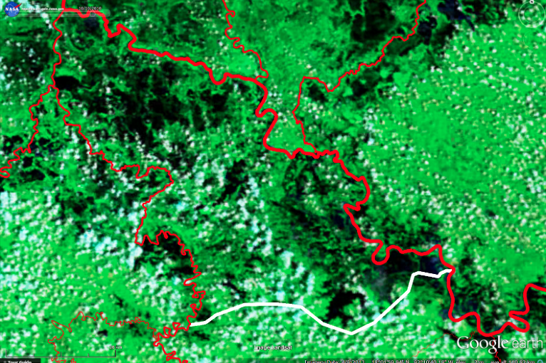
f. By the Bountiful/Desolation boundary line with Bountiful on the south, Desolation on the north Alma 22:32.
i. Line approximately 22.5 kilometers long (standard Nephite unit of distance measure).
ii. Line runs east to west.
iii. Line terminates at the west sea.
iv. Line located at a point where the terrain helps control movement from southward to northward.
v. Line is the west coast boundary of lands southward/northward.
g. By a deep water port on the Bountiful side of the Bountiful/Desolation boundary line Alma 63:5.
h. Neck separate from, but adjacent to the twin lands northward/southward (OED on “between”, OED on “led into”).
i. Land oriented northward/southward Alma 22:32.
j. Neck is one travel corridor, not the exclusive travel corridor from southward to northward Alma 63:5.
i. Close to a second travel corridor, the narrow pass Alma 50:34, 52:9, Mormon 3:5.
ii. Also close to a third travel corridor, the narrow passage Mormon 2:29
k. Neck is in the land southward Alma 63:5.
l. Neck forms part of a perimeter of water nearly (80% +) surrounding the land southward Alma 22:32.
m. Land southward by the neck contains habitat suitable for a game preserve Ether 10:21.
n. Width will not exceed 60 kilometers, much more likely to be less than 5 kilometers (all textual instances of the words “narrow” and “small,” OED on “narrow”).
o. We will find 16 geographic features clustered in close proximity
i. Narrow (small) neck of land Alma 22:32, Alma 63:5, Ether 10:20
ii. City of Lib Ether 10:20
iii. West sea Alma 63:5
iv. West sea, eastern extension Alma 50:34
v. Bountiful/Desolation boundary line (1.5 day’s journey) Alma 22:32, 3 Nephi 3:23
vi. Narrow pass Alma 50:34, 52:9, Mormon 3:5
vii. Narrow passage Mormon 2:29
viii. City of Desolation Mormon 3:5-7
ix. Bountiful defensive line (1 day’s journey) Helaman 4:7
x. Hagoth’s port Alma 63:5
xi. Land Bountiful (west sea portion) Alma 22:32
xii. Land Desolation (southern portion) Alma 22:32
xiii. Land which was near the land Bountiful Helaman 4:5
xiv. Land which was between the land of Zarahemla and the land Bountiful 3 Nephi 3:23
xv. Place where the sea divides the land Ether 10:20
xvi. Teancum/Morianton battlefield Alma 50:34-35
p. The location of the narrow (small) neck region will help explain the enigmatic passage in Mormon 4:4 based on Mormon 3:6.
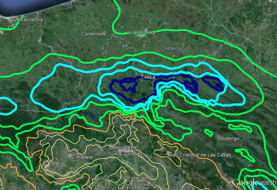
q. The Bountiful/Desolation ecological boundary will be visible in satellite imagery rendered in Google Earth.
r. The land southward/northward political boundary may be preserved on modern maps.
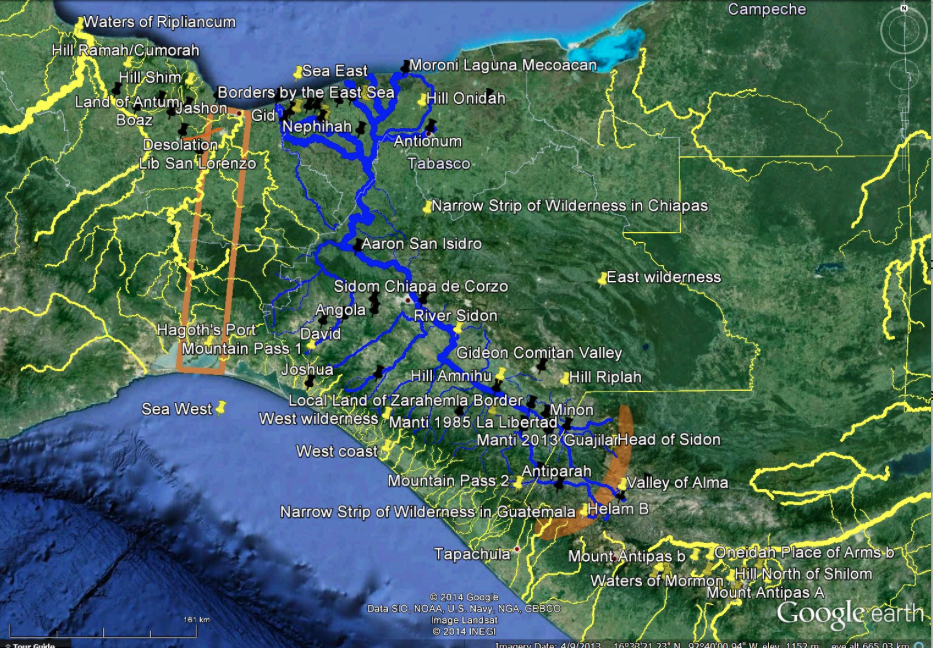
13. We now turn to Google Earth. This powerful and ubiquitous Geographic Information System (GIS) allows us to model correlations and test those models against our criteria. Google Earth answers the questions:
a. Distance?
b. Surface area?
c. Elevation?
d. Rivers?
i. Wetlands?
ii. Drainage basins?
e. Continental divides?
f. Mountains?
i. Mountain peaks visible on the horizon?
ii. Cliffs?
g. Climate?
i. Annual precipitation?
ii. Annual average humidity?
iii. Annual average temperature?
iv. Changes from the rainy season to the dry season?
h. Land use?
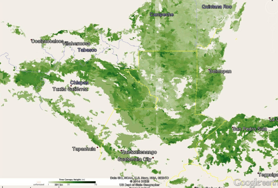
i. Tree canopy height?
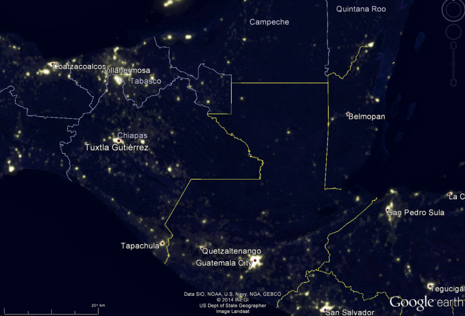
j. Contemporary population density?
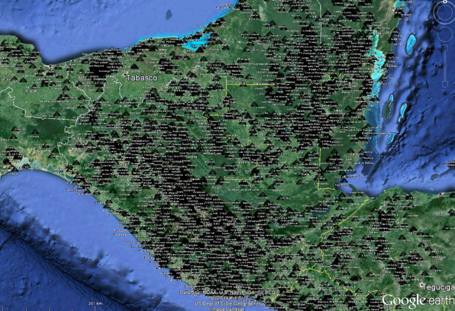
k. Known archaeological site locations?
i. Trade routes?
ii. Ancient roads?
l. Travel corridors?
i. Modern roads?
ii. Modern railroads?
m. Modern place names?
n. Known mineral deposits?
o. Known earthquake epicenters?
p. Volcanoes?
q. Ports?
r. Beaches?
i. Width of sand or rock?
ii. Mangroves?
14. Using Google Earth, we test two leading candidates for the narrow (small) neck of land, the Isthmus of Tehuantepec (IOT) and Barra San Marcos (BSM):
a. Coastal feature Ether 10:20. IOT No, bi-coastal. BSM Yes.
b. By a significant Olmec site Ether 10:20. IOT Yes, Olmec heartland. BSM Yes, Tzutzuculi.
c. Length greatly exceeds width (OED on “narrow”). IOT No. BSM Yes.
d. By an inlet – outlet of the sea Ether 10:20. IOT Yes. BSM Yes.
e. Associated with one and only one sea, the west sea Alma 22:32, Alma 63:5. This means the narrow neck of land was a peninsula, not an isthmus. IOT No. BSM Yes.
f. By the Bountiful/Desolation boundary line with Bountiful on the south, Desolation on the north Alma 22:32. IOT No (Using the Coatzacoalcos as the line). BSM Yes.
i. Line approximately 22.5 kilometers long (standard Nephite unit of distance measure). IOT No. BSM Yes.
ii. Line runs east to west. IOT No. BSM Yes.
iii. Line terminates at the west sea. IOT No. BSM Yes.
iv. Line located at a point where the terrain helps control movement from southward to northward. IOT No. BSM Yes.
v. Line is the west coast boundary of lands southward/northward. IOT No. BSM Yes.
g. By a deep water port on the Bountiful side of the Bountiful/Desolation boundary line Alma 63:5. IOT Yes. BSM Yes.
h. Neck separate from, but adjacent to the twin lands northward/southward (OED on “between”, OED on “led into”). IOT No. BSM Yes.
i. Land oriented northward/southward Alma 22:32. IOT No. BSM Yes.
j. Neck is one travel corridor, not the exclusive travel corridor from southward to northward Alma 63:5. IOT No. BSM Yes.
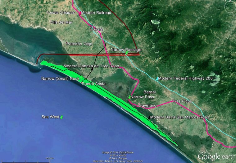
i. Close to a second travel corridor, the narrow pass Alma 50:34, 52:9, Mormon 3:5. IOT Yes (Using the Tehuantepec Ridge as the pass). BSM Yes.
ii. Also close to a third travel corridor, the narrow passage Mormon 2:29 IOT No. BSM Yes.
k. Neck is in the land southward Alma 63:5. IOT No. BSM Yes.
l. Neck forms part of a perimeter of water nearly (80% +) surrounding the land southward Alma 22:32. IOT Yes. BSM Yes.
m. Land southward by the neck contains habitat suitable for a game preserve Ether 10:21. IOT Yes. BSM Yes.
n. Width will not exceed 60 kilometers, much more likely to be less than 5 kilometers (all textual instances of the words “narrow” and “small,” OED on “narrow”). IOT No. BSM Yes.
o. We will find 16 geographic features clustered in close proximity

i. Narrow (small) neck of land Alma 22:32, Alma 63:5, Ether 10:20 IOT Yes. BSM Yes.
ii. City of Lib Ether 10:20 IOT Yes. BSM Yes.
iii. West sea Alma 63:5 IOT Yes. BSM Yes.
iv. West sea, eastern extension Alma 50:34 IOT No. BSM Yes.
v. Bountiful/Desolation boundary line (1.5 day’s journey) Alma 22:32, 3 Nephi 3:23 IOT Yes. BSM Yes.
vi. Narrow pass Alma 50:34, 52:9, Mormon 3:5 IOT Yes. BSM Yes.
vii. Narrow passage Mormon 2:29 IOT No. BSM Yes.
viii. City of Desolation Mormon 3:5-7 IOT Yes. BSM Yes.
ix. Bountiful defensive line (1 day’s journey) Helaman 4:7 IOT No. BSM Yes.
x. Hagoth’s port Alma 63:5 IOT Yes. BSM Yes.
xi. Land Bountiful (west sea portion) Alma 22:32 IOT Yes. BSM Yes.
xii. Land Desolation (southern portion) Alma 22:32 IOT Yes. BSM Yes.
xiii. Land which was near the land Bountiful Helaman 4:5 IOT Yes. BSM Yes.
xiv. Land which was between the land of Zarahemla and the land Bountiful 3 Nephi 3:23 IOT No (following Sorenson). BSM Yes.
xv. Place where the sea divides the land Ether 10:20 IOT Yes. BSM Yes.
xvi. Teancum/Morianton battlefield Alma 50:34-35. IOT Yes. BSM Yes.
p. The location of the narrow (small) neck region will help explain the enigmatic passage in Mormon 4:4 based on Mormon 3:6. IOT No. BSM Yes.
q. The Bountiful/Desolation ecological boundary will be visible in satellite imagery rendered in Google Earth. IOT Yes. BSM Yes.
r. The land southward/northward political boundary may be preserved on modern maps. IOT No. BSM Yes.
15. Netting out duplicates, we have identified 30 discrete criteria for the narrow (small) neck. More could be added if we were to include criteria for the narrow pass, city of Desolation, and the other 16 features closely associated with the narrow (small) neck. The Isthmus of Tehuantepec meets 10 of the criteria, fails on 20. Barra San Marcos meets all 30 criteria with flying colors.
16. We have identified over 300 textual + lexical criteria for Book of Mormon places. Many more await identification. Our proposed correlation fits these 300+ criteria 100%.
17. Here are 7 tests any viable Book of Mormon text to map correlation should pass:
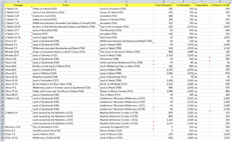
a. The text documents 37 vertical rises (up) and 41 vertical drops (down). Show all 78 elevation differentials.
b. The text documents four different ways Nephite lands could be bifurcated into roughly equal halves. Calculate and compare midpoints or surface areas for all four.
c. Nephite lands during the golden era Alma 50:23 were bounded by the narrow strip of wilderness on the south and the greater land of Zarahemla/land Bountiful border on the north. Demonstrate external corroboration for these cultural boundaries.
d. Three abrupt ecological boundaries are described in the text. Show all three in satellite imagery rendered in Google Earth.
e. The text documents 39 discrete from and to locations where the directional azimuth between them is “north,” “northward,” “northern” or “northernmost.” Show all 39 azimuths within the north quadrant (315 degrees NW to 45 degrees NE). Ditto 36 “south,” “southward” or “south-southeast” location pair azimuths within the south quadrant (225 degrees SW to 135 degrees SE). Ditto 30 “east” location pair azimuths within the east quadrant (45 degrees NE to 135 degrees SE). Ditto 28 “west” location pair azimuths within the west quadrant (315 degrees NW to 225 degrees SW).
f. The text documents 22 instances where the term “day” or a variant is used in a travel context. Deduce an approximate value for the Nephite standard unit of distance measure “one day’s travel” in the Old World (assuming camel caravans) and in the New (assuming pedestrian travel). Show that all relative distances in the text using the word “day” conform to the standard. Deduce likely distance limits for the textual terms “near,” and “far.” Show that all 39 uses of these terms in a spatial context in the text fall within the limits. Deduce a likely distance limit for the textual term “by.” Show that all 88 discrete uses of this term in a spatial context in the text fall within the limit. Since the term “by” is always associated with a margin or littoral, clearly identify the edge feature.
g. We know the Kingdom of Judah, called “land of Jerusalem” in the Book of Mormon, had a land area of approximately 3,762 square kilometers in the 930 B.C. to 586 B.C. era. We know 22 ancient Greek city states had a mean land area of approximately 3,566 square kilometers. 110 Italian Renaissance city states, many of which date to Roman times, had a mean land area of 2,738 square kilometers. 40 ancient English counties, dating to Anglo Saxon times, had a mean land area of 3,214 square kilometers. A number of Maya polities (El Peru, Tikal, Petexbatun State, Hix Wix Kingdom, Piedras Negras, Yaxchilan) were between 1,250 and 2,500 square kilometers in size. The Book of Mormon documents 31 local “lands” with some contextual detail. Show that the mean surface area of these 31 lands falls in the 1,000 to 5,000 square kilometer range deduced from ancient and historical examples of local and regional political entities.
18. The Yale edition is our definitive text. The OED is our definitive lexical resource for Early Modern English. Google Earth is our repository for models and our test bench. Based on the assumptions listed above and the 300+ criteria identified to date, these correlations fit the text 100% and are candidates for consensus:
a. These four entities were explicitly continental – they extended from sea east to sea west:
i. Greater land of Nephi (by ca. 90 B.C.)
ii. Greater land of Zarahemla (after ca. 72 B.C.)
iii. Narrow strip of wilderness
iv. Land Bountiful
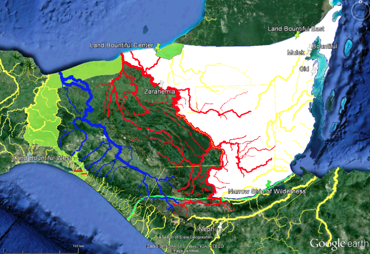
b. The river Sidon was the Chixoy/Salinas/Usumacinta.
c. The head of Sidon was the confluence of the Salama with the Chixoy – Negro.
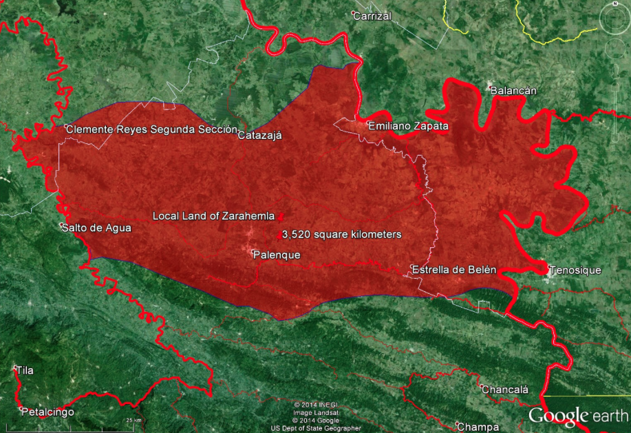
d. The city of Zarahemla in the local land of Zarahemla was downstream on the river Sidon, closer to its mouth than to its head.
e. The land of Melek adjoined the river Sidon with the local land of Zarahemla to its north and the land of Manti to its south.
f. The city and land of Ammonihah were east, not west of river Sidon.
g. In the Melek – Ammonihah region, river Sidon flowed slightly W of NW.
h. The Nephite east coast was the Caribbean coast of Guatemala & Belize.
i. The narrow strip of wilderness was the Polochic Fault along the Caribbean tectonic plate.
19. We don’t have time to present the massive evidence supporting these 9 key correlations. See bookofmormonresources.blogspot.com for 125 articles and counting since August, 2011. We will, though, present more of the evidence supporting the narrow (small) neck of land – Barra San Marcos correlation, contra the Isthmus of Tehuantepec.
a. As we have already seen, Barra San Marcos satisfies 30 of 30 textual & lexical criteria. Tehuantepec only satisfies 10 of 30.
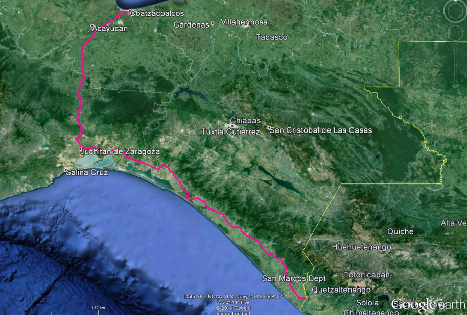
b. We looked at 53 recognized isthmuses around the world, mean width 20.2 kilometers. Tehuantepec at 216 kilometers is the widest isthmus in our sample and it may be the widest on the planet depending on whose definition one accepts for the word “isthmus.”
c. There is another “neck” documented in the text that occurs in a spatial context. It is in 2 Nephi 18:8 quoting Isaiah 8:8. We derived a likely size for this neck: about 2 kilometers wide.
d. We looked at every occurrence of the words “narrow” and “small” in a spatial context in the text and derived a likely width. We concluded any feature exceeding 20 kilometers in width is completely out of the question. The Nephites would not have called it “narrow” or “small” with 5 kilometers a much more likely upper limit.
e. Wandering around in Google Earth, we examined 115 necks of land of the hundreds named during or shortly after the Early Modern English era. 2 of the 115 are tiny isthmuses with widths of .09 and .11 kilometers. 113 are peninsulas. The largest is 19.75 kilometers wide. The mean width is 2.0 kilometers. 9 of the necks have diminutive names such as “narrow” or “little” implying small size. They average .55 km in width. 13 of the necks have augmentative names such as “great,” “broad,” “long” or “big” implying large size. They average 3.88 km in width. 101 of the 115 have exposure to either an estuary or the sea. 3 are called “narrow neck.” They have widths of .09, .11 and 1 kilometer. In summary, based on known necks of land named during the Early Modern English era, we would expect:
i. A peninsula. Barra San Marcos is a peninsula.
ii. A width of about 2.0 kilometers. Barra San Marcos is 2.0 kilometers wide.
iii. Exposure to estuaries and/or salt water. Barra San Marcos fronts the Pacific ocean seaward and saltwater lagoons landward.
8 of the 115 necks of land in our sample have physical characteristics (long, narrow coastal sandbar) very similar to Barra San Marcos.
f. We looked at how the 3 references to “narrow (small) neck of land” are translated in Spanish, Portuguese, French and Italian editions of the Book of Mormon.
i. Spanish: narrow tongue of land.
ii. Portuguese: narrow strip of land.
iii. French: narrow strip & narrow tongue of land.
iv. Italian: narrow tongue of land, narrow isthmus, narrow strip of land.
We might have solved the Book of Mormon map puzzle years ago had we been reading one of these editions.
g. We then examined the OED for the meaning of “neck of land.”
i. In 1527 an English author described the southern part of Nithsdale in Scotland as a “narrow and strait neck.” This part of Nithsdale is 5 kilometers wide.
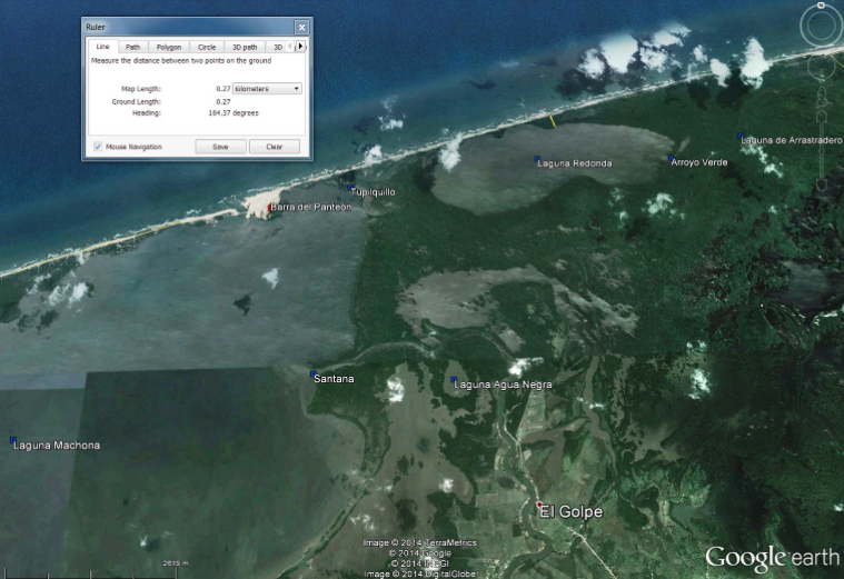
ii. In 1676 an English author described Barra del Panteon on the coast of Tabasco as a “small neck of land.” It ranges from .27 to 2.0 kilometers wide. Barra del Panteon has physical characteristics very similar to Barra San Marcos.
h. Finally, we examined the OED for the meaning of “narrow.” We concluded that geographic features smaller than 5 kilometers wide were routinely called “narrow” in Early Modern English. Features from 5 – 56 kilometers wide were called narrow when compared with large land masses (Scotland, Russia, the Western Hemisphere.) Any geographic feature exceeding 60 kilometers in width would probably not have been called “narrow” in Early Modern English.
i. The small peninsula surrounding Messina, Italy was called a narrow tongue or neck of land by an English author in 1673. It is .40 kilometers wide.
ii. The sandbar surrounding the harbor of Cartagena, Colombia was called a narrow neck of land by an English author in 1630. It is .59 kilometers wide.
iii. The Ards Peninsula in Ireland was called a narrow neck of land by an English author in 1610. It is 4.79 kilometers wide.
20. With the Yale Edition, the OED, and Google Earth, these results are all reproducible by anyone on earth who takes an interest. Science advances based on reproducible results. That gives me hope we can solve the Book of Mormon geography conundrum soon.